las aguas ocultas de valparaíso
TRANSCRIPT
5/10/2018 Las aguas ocultas de Valparaíso - slidepdf.com
http://slidepdf.com/reader/full/las-aguas-ocultas-de-valparaiso 1/6
Las aguas ocultas de Valparaíso1
Marcelo Araya Profesor, Ponticia Universidad Católica de Valparaíso
The hidden waters of Valparaiso1
Marcelo Araya Professor, Ponticia Universidad Católica de Valparaíso
La topografía obliga a modicar la trama urbana regular y genera variaciones tales
como los pliegues que conducen los cursos de agua. Valparaíso se entiende en sus
grietas, en la relación entre los cerros, las aguas y el mar. Es así como sus habitan-
tes se ajustan a la geografía y se benecian de ella.
quebradas como espacios originarios de valparaíso / “Valparaíso está entero
miniado” me dijo hace algunos años un habitante del quinto sector dePlaya Ancha. El diccionario etimológico dene la palabra miniado refe-
rida a los textos miniaturizados de la Edad Media, manuscritos de letrasiluminadas que se nombraron miniadas por ser pintadas con color minio,la pintura de minio que proviene probablemente de la voz celta mein (metal de oro). La lengua, que retorna siempre por caminos recónditos,le conere al poblador la razón del origen del vocablo. El minios u oro delas minas, las galerías por debajo de la tierra. Valparaíso está enteramente miniado o minado: son los caminos delagua o las galerías subterráneas que forman parte del gran sistema dequebradas abovedadas de la ciudad, que nacieron cuando comenzó la ocu-pación de los cerros por los habitantes y se encontraron con la dicultadde subir por el cauce. La quebrada es el ámbito urbano originario de Val-paraíso, el primero que se pobló y donde primero se encaramaron lascasas (Urbina, 2002). En un principio la ocupación se hizo por veredas ohuellas en los márgenes de la quebrada —aún hoy se pueden encontraren su curso superior— y con el tiempo, considerando que gran parte del
año la quebrada no tiene agua, se comenzó a utilizar su fondo y poste-riormente cubrirlo, dejando siempre espacio por donde escurra el agua.Se establece así la bóveda que genera un suelo articial, se allana el plie-gue y la arruga íntima se transforma, en la medida que es posible, enpública. La quebrada natural es íntima y se des-intima cuando se cubrecon una losa. Así se abovedaron las quebradas, lo que dio origen a plazasa pie de cerro en Valparaíso. (Álvarez, 2001)Las quebradas son una abertura natural que, a medida que la ciudad
crece, se vuelven subterráneas, llevan el agua pero no se la ve, se intuyepero se ignora.
Esta ciudad más que ninguna se soterra. Sólo cuando el molo de abrigono contiene al mar y cuando los colectores de las quebradas colapsan escuando los ciudadanos comienzan a entender las antiguas estructurasdel paisaje.
la grieta / Para conocer Valparaíso se dice normalmente: “Vamos a
ir por la calle del borde, Errázuriz, luego subiremos a Avenida Alemania y
así veremos los cerros, para luego bajar a dar una vuelta en lancha por la
bahía”. Estos son todos ejes que, en semicírculos, muestran el largode la ciudad en directa relación con el mar, con su borde. Es siempreuna mirada desde fuera.
Para el porteño2 la relación que tiene con la ciudad es otra, la dehabitar el pliegue. Una mirada desde dentro, comprometido con latrama urbana, ese trazado particular que sigue las huellas d iseñadashace siglos por la erosión del agua lluvia, el mar abrasivo, los ani-males, las personas.
The topography forces the modication of the regular urban weave and generates
variations, such as the folds leading the waterways. Valparaiso is understood in its
crevices, in the relationships between the hills, the waters and the sea. It is in this way
that its inhabitants adapt to the geography and benet from it.
Palabras clave: Urbanismo-Chile, topografía, morfología urbana, vialidad, hidrografía, tipos humanos. Key words: Chilean-Urbanism, topography, urban morphology, road works, hydrography, human types.
40 Lecturas Readings73
crevices as originary spaces of valparaiso / “Valparaiso is completely minimized
a habitant of the fth sector of Playa Ancha once said to me a few yearago. The etymological dictionary denes the word minimized in referenc
to the miniaturized texts of the Middle Ages, manuscripts of illuminateletters that were named minimized for being painted in the color miniumthe color minuim probably coming from the Celtic mein (gold metal). Language, which always returns by recondite paths, confers to the settler threason for the origin of the word. The minuims or gold of the mines, thgalleries underneath the earth.Valparaiso is entirely minimized or mined: refers to the waterways or th
underground galleries that form part of the great system of vaulted gorge
of the city, which were created when the hills were initially settled bythe inhabitants and were confronted with the difculty of ascending vithe channel. The crevice is the original urban realm of Valparaiso, therst that was occupied and where the rst houses were raised (Urbina2002). To begin with, the occupation took place on the sidewalks or onthe paths at the rims of the crevices —still today their upper section canbe found— and with time, considering that the crevice had no wate
great part of the year, its bottom started to be utilized, but always leavinenough space for water to ow. Thus, the vault is established, generating an articial oor, the folds are smoothed and the intimate wrinklbecomes, in the extent that is possible, into public. The natural crevice iintimate and becomes not-intimate when it is covered with a slab. Therefore, the crevices were vaulted and gave origin to the squares at the foothills in Valparaiso. (Álvarez, 2001)The crevices are a natural opening that in the extent that the city grow
they become underground, taking the waters, but are unseen, one perceives them but they are ignored.
This city, more than any other, is buried. Only when the sea waldoes not contain the sea and when the collectors of the crevices collapse, is when the citizens begin to understand the old structures othe landscape.
the crevice / To know Valparaiso normally it is said: “Lets go on the edg
street, Errázuriz, then go up to Avenida Alemania and thus we’ll see the hills, to
then go back down for a bay ride on a boat”. These are all of the axis that insemicircles, illustrate the length of the city in direct relationship withthe sea, with its edge. It’s always a view from the outside.For the porteño 2 the relation that it has with the city is another one, i
is to inhabit the fold. A view from the inside which embraces the urba weave, that particular trace that follows the paths designed centurieago by the erosion of rain water, the abrasive sea, the animals, people.
5/10/2018 Las aguas ocultas de Valparaíso - slidepdf.com
http://slidepdf.com/reader/full/las-aguas-ocultas-de-valparaiso 2/6
1 La planimetría presentada en
este artículo fue realizada por los
titulantes de Diseño de Objetos de
la Ponticia Universidad Católica
de Valparaíso, Sandra Ureta Marín y
Pedro Garretón Izquierdo.
2 Porteño es nacido en Valparaíso.
1 La planimetría presentada en
este artículo fue realizada por los
titulantes de Diseño de Objetos de
la Ponticia Universidad Católica
de Valparaíso, Sandra Ureta Marín y
Pedro Garretón Izquierdo.
2 Porteño is native of Valparaíso.
73Lecturas Readings
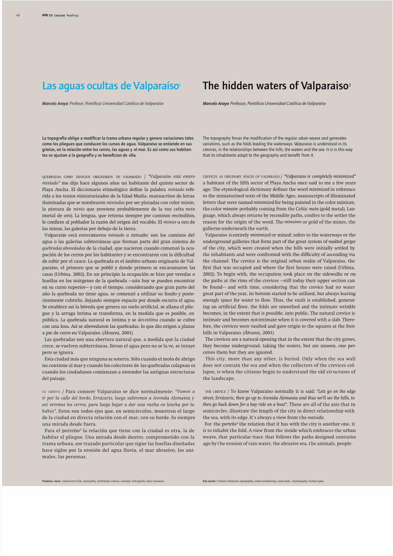
01 Bóvedas. Croquis del autor
01 Vaults. Author’s sketches
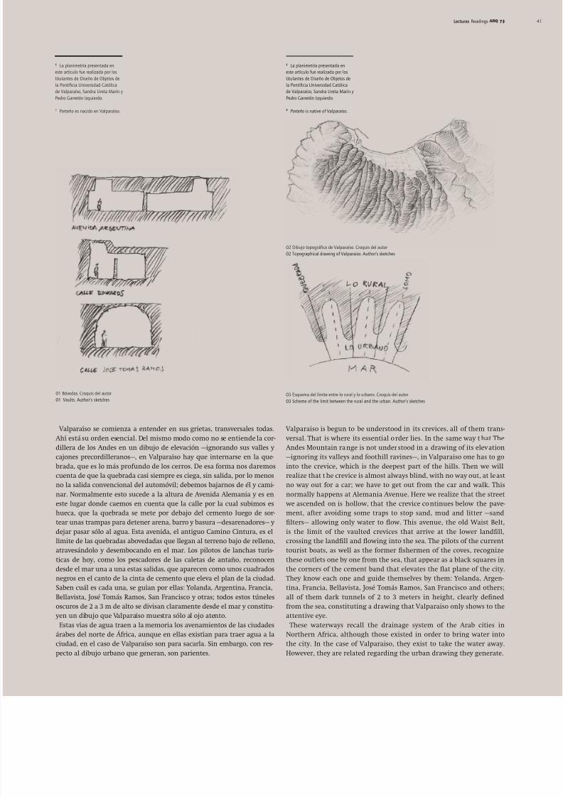
Valparaíso se comienza a entender en sus grietas, transversales todas. Ahí está su orden esencial. Del mismo modo como no se entiende la cor-dillera de los Andes en un dibujo de elevación —ignorando sus valles ycajones precordilleranos—, en Valparaíso hay que internarse en la que- brada, que es lo más profundo de los cerros. De esa forma nos daremoscuenta de que la quebrada casi siempre es ciega, sin salida, por lo menosno la salida convencional del automóvil; debemos bajarnos de él y cami-nar. Normalmente esto sucede a la altura de Avenida Alemania y es eneste lugar donde caemos en cuenta que la calle por la cual subimos eshueca, que la quebrada se mete por debajo del cemento luego de sor-tear unas trampas para detener arena, barro y basura —desarenadores— ydejar pasar sólo al agua. Esta avenida, el antiguo Camino Cintura, es ellímite de las quebradas abovedadas que llegan al terreno bajo de relleno,atravesándolo y desembocando en el mar. Los pilotos de lanchas turís-
ticas de hoy, como los pescadores de las caletas de antaño, reconocendesde el mar una a una estas salidas, que aparecen como unos cuadradosnegros en el canto de la cinta de cemento que eleva el plan de la ciudad.Saben cuál es cada una, se guían por ellas: Yolanda, Argentina, Francia,Bellavista, José Tomás Ramos, San Francisco y otras; todos estos túnelesoscuros de 2 a 3 m de alto se divisan claramente desde el mar y constitu- yen un dibujo que Valparaíso muestra sólo al ojo atento.
Estas vías de agua traen a la memoria los avenamientos de las ciudadesárabes del norte de África, aunque en ellas existían para traer agua a laciudad, en el caso de Valparaíso son para sacarla. Sin embargo, con res-pecto al dibujo urbano que generan, son parientes.
02 Dibujo topográco de Valparaíso. Croquis del autor
02 Topographical drawing of Valparaiso. Author’s sketches
03 Esquema del límite entre lo rural y lo urbano. Croquis del autor
03 Scheme of the limit between the rural and the urban. Author’s sketches
Valparaiso is begun to be understood in its crevices, all of them trans- versal. That is where its essential order lies. In the same way that The Andes Mountain range is not understood in a drawing of its elevation—ignoring its valleys and foothill ravines—, in Valparaiso one has to gointo the crevice, which is the deepest part of the hills. Then we willrealize that the crevice is almost always blind, with no way out, at leastno way out for a car; we have to get out from the car and walk. Thisnormally happens at Alemania Avenue. Here we realize that the street we ascended on is hollow, that the crevice continues below the pave-ment, after avoiding some traps to stop sand, mud and litter —sandlters— allowing only water to ow. This avenue, the old Waist Belt,is the limit of the vaulted crevices that arrive at the lower landll,crossing the landll and owing into the sea. The pilots of the currenttourist boats, as well as the former shermen of the coves, recognize
these outlets one by one from the sea, that appear as a black squares inthe corners of the cement band that elevates the at plane of the city.They know each one and guide themselves by them: Yolanda, Argen-tina, Francia, Bellavista, José Tomás Ramos, San Francisco and others;all of them dark tunnels of 2 to 3 meters in height, clearly denedfrom the sea, constituting a drawing that Valparaiso only shows to theattentive eye.
These waterways recall the drainage system of the Arab cities inNorthern Africa, although those existed in order to bring water intothe city. In the case of Valparaiso, they exist to take the water away.However, they are related regarding the urban drawing they generate.
5/10/2018 Las aguas ocultas de Valparaíso - slidepdf.com
http://slidepdf.com/reader/full/las-aguas-ocultas-de-valparaiso 3/6
7342 Lecturas Readings42
El método árabe de extracción de agua era ubicar en la tierra una zonahúmeda, establecer su dirección y construir un túnel subterráneo de cerá-
mica, pequeño primero y mayor después, que a través de la porosidad del barro cocido iba sudando agua. Así se podía captar el suciente líquidopara abastecer una ciudad. Madrid, que pertenece al sistema hispano-árabe, cuenta con una estructura compleja de vías de agua subterráneas(Oliver, 1996). Estas vías debían tener respiraderos cada ciertos metrospara asegurar su buen funcionamiento, el que era controlado por un cela-
dor de aguas, quien caminaba uniendo en línea los respiraderos. Con estogeneró una huella, que luego se hizo camino, coincidente con la galeríacaptadora de agua a 3 ó 4 m bajo tierra. La vía de agua demarcó las calles,por tanto, la trama de la ciudad.En Valparaíso sucedió que la vía de agua —la quebrada— siempre exis-
tió, pero a nes del s. xix las calles que iban por el fondo de quebrada secubrieron con una bóveda de piedra y hormigón, para separar el tránsitodel hombre del tránsito del agua, desde el plan hasta la cota de los 100m. Es el mismo principio: una vía de paso sobre una vía de agua donde la
última determina la primera. Esto diferencia a Valparaíso de la mayoríade las ciudades hispanoamericanas construidas en terreno llano, dondeel ordenamiento urbano se genera a partir de la división administrativadel suelo. En ellas el agua de las acequias debió saber ser incorporada acada uno de los solares. Por tanto la trama urbana generó el dibujo deltrazado del agua.Lo dicho anteriormente sobre la quebrada se reere principalmente a la
primera franja, la que se despliega desde el borde del mar hasta Avenida Alemania que, construida aproximadamente sobre la cota 100 msnm —elantiguo Camino Cintura— en una obra ejecutada en la década de 1870,une los cerros desde Avda. Francia —antigua quebrada de Jaime— hastaPlaya Ancha. En dicha avenida se encuentra la cadena de desarenadores.
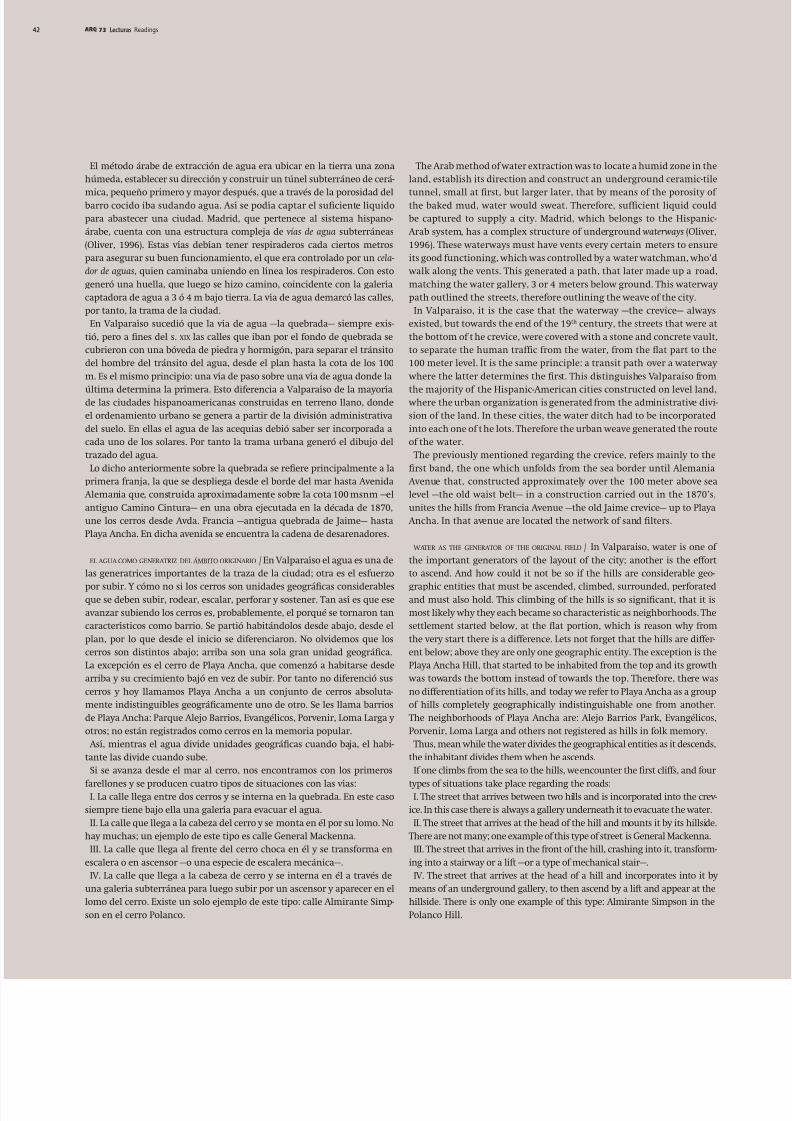
el agua como generatriz del ámbito originario / En Valparaíso el agua es una delas generatrices importantes de la traza de la ciudad; otra es el esfuerzo
por subir. Y cómo no si los cerros son unidades geográcas considerablesque se deben subir, rodear, escalar, perforar y sostener. Tan así es que eseavanzar subiendo los cerros es, probablemente, el porqué se tornaron tancaracterísticos como barrio. Se partió habitándolos desde abajo, desde elplan, por lo que desde el inicio se diferenciaron. No olvidemos que loscerros son distintos abajo; arriba son una sola gran unidad geográca.La excepción es el cerro de Playa Ancha, que comenzó a habitarse desdearriba y su crecimiento bajó en vez de subir. Por tanto no diferenció suscerros y hoy llamamos Playa Ancha a un conjunto de cerros absoluta-mente indistinguibles geográcamente uno de otro. Se les llama barriosde Playa Ancha: Parque Alejo Barrios, Evangélicos, Porvenir, Loma Larga yotros; no están registrados como cerros en la memoria popular.Así, mientras el agua divide unidades geográcas cuando baja, el habi-
tante las divide cuando sube.Si se avanza desde el mar al cerro, nos encontramos con los primeros
farellones y se producen cuatro tipos de situaciones con las vías:I. La calle llega entre dos cerros y se interna en la quebrada. En este caso
siempre tiene bajo ella una galería para evacuar el agua.II. La calle que llega a la cabeza del cerro y se monta en él por su lomo. No
hay muchas; un ejemplo de este tipo es calle General Mackenna.III. La calle que llega al frente del cerro choca en él y se transforma en
escalera o en ascensor —o una especie de escalera mecánica—.IV. La calle que llega a la cabeza de cerro y se interna en él a través de
una galería subterránea para luego subir por un ascensor y aparecer en ellomo del cerro. Existe un solo ejemplo de este tipo: calle Almirante Simp-son en el cerro Polanco.
The Arab method of water extraction was to locate a humid zone in thland, establish its direction and construct an underground ceramic-til
tunnel, small at rst, but larger later, that by means of the porosity othe baked mud, water would sweat. Therefore, sufcient liquid couldbe captured to supply a city. Madrid, which belongs to the Hispanic Arab system, has a complex structure of underground waterways (Oliver1996). These waterways must have vents every certain meters to ensurits good functioning, which was controlled by a water watchman, who’ walk along the vents. This generated a path, that later made up a roadmatching the water gallery, 3 or 4 meters below ground. This waterwapath outlined the streets, therefore outlining the weave of the city.In Valparaiso, it is the case that the waterway —the crevice— alway
existed, but towards the end of the 19th century, the streets that were athe bottom of t he crevice, were covered with a stone and concrete vaulto separate the human trafc from the water, from the at part to th100 meter level. It is the same principle: a transit path over a waterwa where the latter determines the rst. This distinguishes Valparaiso from
the majority of the Hispanic-American cities constructed on level land where the urban organization is generated from the administrative divsion of the land. In these cities, the water ditch had to be incorporatedinto each one of the lots. Therefore the urban weave generated the routof the water.The previously mentioned regarding the crevice, refers mainly to the
rst band, the one which unfolds from the sea border until Alemania Avenue that, constructed approximately over the 100 meter above selevel —the old waist belt— in a construction carried out in the 1870’sunites the hills from Francia Avenue —the old Jaime crevice— up to Playa Ancha. In that avenue are located the network of sand lters.
water as the generator of the original field / In Valparaiso, water is one othe important generators of the layout of the city; another is the efforto ascend. And how could it not be so if the hills are considerable geo
graphic entities that must be ascended, climbed, surrounded, perforatedand must also hold. This climbing of the hills is so signicant, that it imost likely why they each became so characteristic as neighborhoods. Thsettlement started below, at the at portion, which is reason why fromthe very start there is a difference. Lets not forget that the hills are different below; above they are only one geographic entity. The exception is thPlaya Ancha Hill, that started to be inhabited from the top and its growt was towards the bottom instead of towards the top. Therefore, there wano differentiation of its hills, and today we refer to Playa Ancha as a groupof hills completely geographically indistinguishable one from anotherThe neighborhoods of Playa Ancha are: Alejo Barrios Park, EvangélicosPorvenir, Loma Larga and others not registered as hills in folk memory.Thus, mean while the water divides the geographical entities as it descends
the inhabitant divides them when he ascends.If one climbs from the sea to the hills, we encounter the rst cliffs, and four
types of situations take place regarding the roads:I. The street that arrives between two hills and is incorporated into the crev
ice. In this case there is always a gallery underneath it to evacuate the water.II. The street that arrives at the head of the hill and mounts it by its hillside
There are not many; one example of this type of street is General Mackenna.III. The street that arrives in the front of the hill, crashing into it, transform
ing into a stairway or a lift —or a type of mechanical stair—.IV. The street that arrives at the head of a hill and incorporates into it b
means of an underground gallery, to then ascend by a lift and appear at thehillside. There is only one example of this type: Almirante Simpson in thePolanco Hill.
5/10/2018 Las aguas ocultas de Valparaíso - slidepdf.com
http://slidepdf.com/reader/full/las-aguas-ocultas-de-valparaiso 4/6
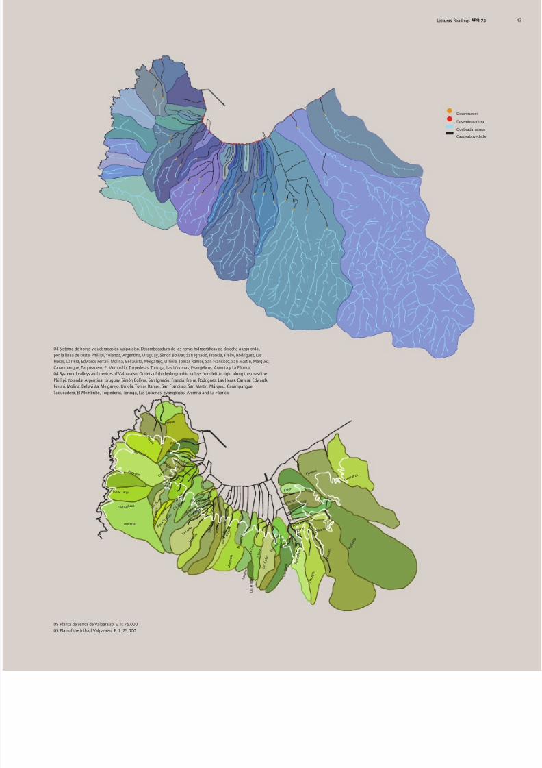
04 Sistema de hoyas y quebradas de Valparaíso. Desembocadura de las hoyas hidrográcas de derecha a izquierda ,
por la línea de costa: Phillipi, Yolanda, Argentina, Uruguay, Simón Bolívar, San Ignacio, Francia, Freire, Rodríguez, Las
Heras, Carrera, Edwards Ferrari, Molina, Bellavista, Melgarejo, Urriola, Tomás Ramos, San Francisco, San Martín, Márquez,
Carampangue, Taqueadero, El Membrillo, Torpederas, Tortuga, Las Lúcumas, Evangélicos, Animita y La Fábrica.
04 System of valleys and crevices of Valparaiso. Outlets of the hydrographic valleys from left to right along the coastline:
Phillipi, Yolanda, Argentina, Uruguay, Simón Bolívar, San Ignacio, Francia, Freire, Rodríguez, Las Heras, Carrera, Edwards
Ferrari, Molina, Bellavista, Melgarejo, Urriola, Tomás Ramos, San Francisco, San Martín, Márquez, Carampangue,
Taqueadero, El Membrillo, Torpederas, Tortuga, Las Lúcumas, Evangélicos, Animita and La Fábrica.
Desarenador
Desembocadura
Quebrada natural
Cauce abovedado
05 Planta de cerros de Valparaíso. E. 1: 75.000
05 Plan of the hills of Valparaiso. E. 1: 75.000
P a r q u e
Artilleria
P l a y a A n c h a
S t a
. T e r e
s a
M i r a m a r
P o r v e n i r
Animitas
Loma Lar ga
E vangélicos
P o l a n c
o R e c
r e o
L a r r a i n
L e c h e r
o s
B a r o n
C o n c e
p c i ó n
C o r d
i l l e r a
C á r c e
l P a n t e ó n
L a L o m a
B e
l l a v
i s t
a S a n
J u a n
Y u n g a y
J i m e n
e z
M i r a f
o r e s
A l e g r e
F l o
r i d a
M a r i p
o s a
M o n j a s
L a C
r u z
T o r o
S t o D o m i n g o
Ar r a y a n
R e i n a
V i c t o r
i a
C h
a p a r r o
L o s P i
n o s
P e r d i c e s
M e s i l l a
C a r r e t a
s
A g u a
P o t a b l
e
J a r c
i a s
P l a c e r e s
E s p e r a n
z a
O ´ H
i g g i n
s
R a m a d i t a
s M e r c e d
L a V i r g e n
E l L i t r e
L a s C
a ñ a s
S t
a .
E l e
n a
R o d e l i l l o
D e l i c i a s
R o c u a n t
L a t o r r e
M o l i n o
S n
F r a n c
i s c o
L a s P i e d r a s
73Lecturas Readings

5/10/2018 Las aguas ocultas de Valparaíso - slidepdf.com
http://slidepdf.com/reader/full/las-aguas-ocultas-de-valparaiso 5/6
73 Lecturas Readings4444
Todas las vías de la ciudad que llegan al cerro corresponden a variacio-nes de estos cuatro ejemplos.
Las calles que suben por el lomo o los ascensores y escaleras, que luegose transforman en calles largas por el centro del cerro, continúan ascen-diendo siempre por el lomo. En cambio, la calle que sube por el fondo dequebrada normalmente se interrumpe en la cota 100 m, en la Avenida Alemania. En este punto la calle, que no es más que una cubierta sobrela quebrada, deja de serlo para dar paso a la quebrada natural. Aquí pasaalgo singular, porque a los lados de la quebrada suben caminos de tierra.Estos caminos se transforman en huellas después y no abandonarán lacañada hasta que esta desaparezca. Desde la cota 100 hasta los 200 m máso menos es un camino de tierra normal, luego una vereda peatonal hastalos 250 ó 300 m. Desde ahí hacia arriba es una huella de pezuña de ciriaco3,caballo y pie de hombre. Después de esta aún siguen pequeñas huellas vernáculas, caminos de perros cimarrones —salvajes o alzados— conejos yroedores. Siempre esas huellas saldrán a la parte alta de los cerros y, conel tiempo, harán el camino de vuelta para convertirse progresivamente
en huellas mayores, veredas, caminos de tierra, pasajes y calles.En este ámbito se genera una intimidad con el paisaje que, aunque
urbana, tiene mucha relación con la retroalimentación rural. La leñapara cocinar y la leña de venta proviene en gran medida de extraccionesilegales del bosque de eucaliptos o espino que rodea la ciudad desde los300 m hacia arriba. Los troncos son arrastrados por caballos o burroshasta el punto donde son desmenuzados y trozados a la medida de loshornos de las panaderías o los calefactores domésticos.
los espacios de la quebrada y sus tipos humanos / Sobre la línea de los desare-nadores aparece nuevamente la quebrada íntima no cubierta. En estasegunda franja se establecen las diferencias del habitante relacionadasal lugar del cerro donde reside: el habitante del fondo de quebrada —elquebradeño— y el que vive en el lomo —el lomero—.Estos dos casos corresponden a dos paisajes formados principalmente
por el agua, ya sea en su condición de elemento pluvio-erosionante —queconstruye la grieta transversal— o como masa de agua de mar abrasivaen los diferentes estratos glaciares, que construye las terrazas longitudi-nales a 50, 100 y 140 msnm (Álvarez, 1963).En las huellas menores abundan los huaches 4, que suministran carne de
conejo o liebre para las tomas de terreno que rodean la ciudad y que seubican desde el último punto donde llega el suministro de agua potable—300 m— hasta donde comienza el bosque —350 a 400 m—.En este rango de cotas es donde también brotan pequeños manantiales
o aguas de vertiente que logran mantenerse en los meses más secos del verano. En los lugares donde aparecen se construyen pozos que se pro-tegen de animales y basura. Estos pequeños surtidores de agua relativa-mente limpia se ocupan para abrevar animales, regar huertas y chacras y, ocasionalmente, para uso doméstico, ya sea para la propia familia oincorporando también a los vecinos más próximos. El dueño de los pozos
es el quebradeño, personaje que habita la quebrada desde Avenida Alema-nia hacia arriba. Su característica principal es que es de índole más ruralque el resto de los porteños, cuenta con animales de carga y de consumo,cabras, caballos y un cerdo quizás, plantíos básicos, huerta pequeña, sacaleña del bosque cercano y cuenta con agua propia; la quebrada lo pro-tege. Puede suponerse que su padre o abuelo, que llegó a Valparaíso aprincipios de siglo, eligió este lugar más verde y con presencia de agua,que le recordaba los valles interiores de los cuales provenía. Más que la vista al mar le interesó plantar árboles de pradera. Así, los álamos carac-terísticos del campo chileno aparecen aquí entre las esclerólas endémi-cas boldo, peumo, litre y arrayán.
All the streets of the city arriving at hills corresponds to variations of thesfour examples.
The streets that climbs on the hillside, or the lifts and stairways, thathen become long streets on the center of the hills, continue ascendinalways on the hillside. In turn, Alemania Avenue normally interruptthe street that ascends from the bottom of the crevice on the 100 m leve At this point, the street, that wasn’t more than a cover over the crevicestops being a cover and gives way to the natural crevice. Here somethinunique happens, because at the sides of the crevice dirt-paths ascendThese paths later transform into footpaths and don’t abandon t he gorguntil it disappears. From the 100m level until the 200 m more or lessit is a normal dirt road, then a pedestrian way until the 250 m or 300m. From there on upwards, it is a path of pezuña de ciriaco3, horses andfootpath. After these, small vernacular paths still continue, as well apaths of runway dogs —wild or erce— rabbits and rodents. These pathalways come out at the top of the hills, and with time they return, con verting progressively into larger paths, sidewalks, dirt roads, passage
and streets.In this realm, an intimacy with the landscape is generated that, even
though urban, has a lot of relation with rural feedbacks. The rewoodfor cooking and the rewood for sale come mostly from illegal extractions of the eucalyptus or hawthorn forests that surround the city at th300 m level upwards. Horses or donkeys drag the trunks until the plac where they are crumbled and broken down in sizes according to thfurnaces of the bakeries or the domestic heating machines. the spaces of the crevice and its human types / Over the line of the sand-lter
appears once again the intimate un-covered crevice. In this second bandthe differences of the inhabitants are established in relation to the placin the hills where they reside: the inhabitant of the bottom of the crevic—the quebradeño— and the ones who live on the hillside —el lomero—.These two cases correspond to two landscapes formed mainly by water
be it in its condition of rain erosive element —that constitutes the trans versal gorge— or as abrasive water mass in the different glacial stratasthat constitutes the longitudinal terraces at 50, 100 and 140 meters abovsea level (Álvarez, 1963).In the smaller paths abound the huaches 4, providing rabbit or hare mea
for the land takings that surround the city and that are located from thlast point where drinkable water is available —300 m— until where thforest begins —350 to 400 m—. In these levels is where slope-springs or small rivers appear, whichmanage to remain wet in the driest months of the summer. In the place where these appear, wells are built to protect them from animals antrash. These small, relatively clean water fountains are used to feed animals, to water kitchen gardens and small farms, as well as occasionallyfor domestic use, be it for the family themselves or for the closest neighbors. The owner of the well is the quebradeño, a person who inhabits th
crevice from Alemania Avenue upwards. His main characteristic is thahe’s more rural natured than the rest of the porteños, he has load-bearingand consumption animals, goats, horses and perhaps even pigs, he hasbasic plantations, a small kitchen garden, gets rewood from the foresnearby and has his own water; the crevice protects him. It can be assumedthat his father or grandfather, who chose Valparaiso at the beginning othe century, selected this greener place with water available, because ireminded him of the interior country valleys from where he came fromMore than the view to the sea, he was interested in planting meadowtrees. As such, poplars, characteristic of the Chilean countryside, appeahere amongst the sclerophyll endemic boldo, peumo, litre and arrayán.
5/10/2018 Las aguas ocultas de Valparaíso - slidepdf.com
http://slidepdf.com/reader/full/las-aguas-ocultas-de-valparaiso 6/6
S a n t o D o m i n g o
S a n F r a n c i s c o
L o s P i n o s
B a r ó n
E s p e r a n z a
P l a c e r e s
L e c h e r o s
R e c r e o
L a r r a í n
R o c u a n t
R a m a d i t a s
R o d e l i l l o
S a n t a H e l e n a
L a C r u z
L a t o r r e
M a r i p o s a
Y u n g a y
M o n j a s
J a r c i a s
P o l a n c o
M o l i n o
R o d r i g u e z
D e l i c i a s
O ` H i g g i n s L
a V i r g e n
M e r c e d
L a s C a ñ a s
E l L i t r e
F l o r i d a
B e l l a v i s t a
P a n t e ó n
S a n J u a n
J i m é n e z
C á r c e l
R e i n a V i c t o r i a
M i r a o r e s
L a L o m a
C o n c e p c i ó n
A l e g r e
C o r d i l e r a
A g u a P o t a b l e
C h a p a r r o
T o r o
P e r d i c e s
M e s i l l a
C a r r e t a s
A r r a y á n
A r t i l e r í a
P l a y a A n c h a
73Lecturas Readings
Vecino del quebradeño, a no más de 100 m arriba, vive el habitante dela loma, el lomero. Este es un ciudadano más público, que mira la bahíadesde la altura, controla los tránsitos desde el centro del cerro, los micro- buses suben por su calle, no tiene agua pero sabe cómo conseguirla yprerió la conectividad a la posibilidad de riego. Su calle es innita, naceen el borde del mar y se prolonga indenidamente hacia la parte altade la ciudad, lo que en denitiva lo conecta con el mundo. Esta mismarelación lo hace comerciante; es dueño del almacén del cerro que casisiempre está ubicado en la intersección de la calle central con algunatransversal al lomo. La sede social o el comité —si se trata de habitantesde una toma— se ubica generalmente en este espacio del cerro.Si visualizáramos la relación entre ambos personajes diríamos que
la ocupación espacial del terreno en que se establecen es al modo de
un engranaje, en que lo urbano avanza subiendo por la loma del cerro—administración vecinal, calles pavimentadas y agua potable—, pero seretrae en la quebrada. De la misma manera lo rural, que es lo que rodeala ciudad, avanza en sentido opuesto bajando por la quebrada e introdu-ciéndose en lo urbano.Lo interesante es la convivencia e interacción entre estas diferentes
tipologías que, a diferencia de lo que probablemente sucedería en unterreno plano en que se polarizarían estableciendo una barrera sólidaentre ambas, producto de la pendiente el paso de una a otra es abso-lutamente gradual, tanto que la mayoría de ellos no se reconocen a símismos en ninguno de los dos ámbitos. Así uno de los aspectos culturales más importantes y signicativosde Valparaíso está oculto a simple vista y se encuentra desde Avenida Alemania hacia arriba; es donde tiene lugar esta singular manera deestablecer el límite a partir de la pendiente, entre lo construido y lo
agreste.
Bibliografía
Álvarez, Leonardo. Geología del área Valparaíso-Viña del Mar. Instituto de
Investigaciones Geológicas, Santiago, 1963. / Álvarez, Luis. “Origen de los
espacios públicos en Valparaíso”. Revista de Urbanismo, N° 4. Universidad de
Chile, Santiago, 2001 / Oliver, Jaime. Historia del nombre de Madrid. Agencia
Española de Cooperación Internacional, Madrid, 1996. / Urbina, Ximena. Los
conventillos de Valparaíso, 1880 – 1920. Fisonomía y percepción de una vivienda popu-
lar urbana. Ediciones Universitarias de Valparaíso, Valparaíso, 2002.
3 Burro de baja alzada utilizado
para el transporte de carga.
4 Pequeños lazos corredizos de
acero que se ponen en las huellas
de paso de la presa para atraparlo
del cuello
3 Low height donkeys used for load
transport.
4 Small sliding steel loops that are
put in the tracks of the prey to catch
them by the neck.
Neighbor to the quebradeño, at not more than the 100 m level, lives theinhabitant of the hillside, the lomero. This is a more public citizen thatlooks to the bay from the heights, controls the trafc from the center of the hill, the buses ascend via his streets, doesn’t have water but knowshow to get it and preferred connectivity than the possibility of irrigation.His street is innite, being born at the edge with the sea and extendsindenitely towards the upper part of the city, this being what reallyconnects him to the world. This same relation makes him a retailer; heis the owner of the store of the hill, which is almost always located at theintersection of the central street with the one transversal to the hillside.The community center, or the committee —if related to inhabitants of aland taking— is generally located in this space of the hill.If we visualize the relationship amongst both personalities we would
say that the spatial occupation of the land in which they settle is by way of a gear, in which the urban advances ascending on the hillside—neighborhood administration, paved streets and drinking water—, butcontracts in the crevice. In the same way, the rural, which is what sur-rounds the city, advances in the opposite direction descending onto thecrevice and introducing itself in the urban. What is of interest is the coexistence and interaction between these dif-ferent typologies that, different to what would normally happen in a atland in which polarization would take place establishing a solid barrierbetween both, here as a consequence of the slope, the passage from oneto another is completely gradual, so much so that the majority of themdon’t recognize themselves in any of the two realms.Thus, one of the more important cultural and signicant aspects of
Valparaiso is hidden at a rst glance and is found from Alemania Avenueupwards; this is where takes place this singular manner of establishing
the limit, arising the slope, between the constructed and the rustic.
Bibliography
Álvarez, Leonardo. Geología del área Valparaíso-Viña del Mar. Instituto de
Investigaciones Geológicas, Santiago, 1963. / Álvarez, Luis. “Origen de los
espacios públicos en Valparaíso”. Revista de Urbanismo, No4. Universidad de
Chile, Santiago, 2001 / Oliver, Jaime. Historia del nombre de Madrid. Agencia
Española de Cooperación Internacional, Madrid, 1996. / Urbina, Ximena. Los
conventillos de Valparaíso, 1880 – 1920. Fisonomía y percepción de una vivienda popu-
lar urbana. Ediciones Universitarias de Valparaíso, Valparaiso, 2002.
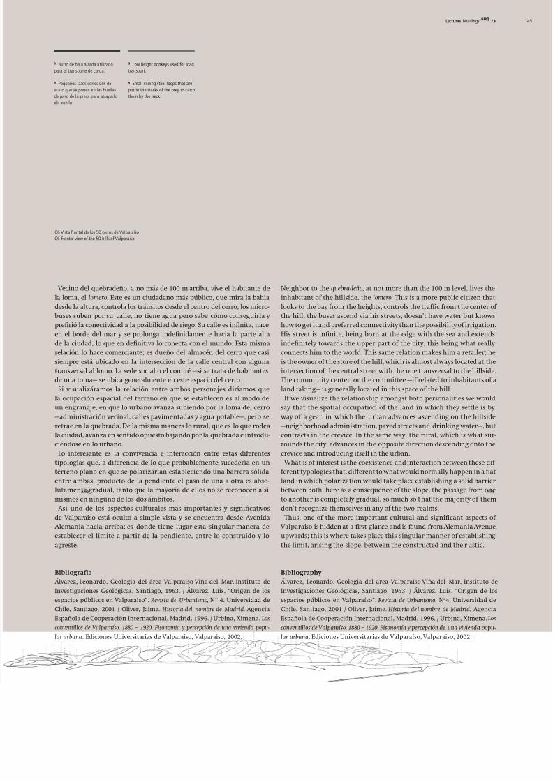
06 Vista frontal de los 50 cerros de Valparaíso
06 Frontal view of the 50 hills of Valparaiso