informe del taller regional del pacÍfico … · inmediatamente después de un taller de...
TRANSCRIPT
/...
A fin de minimizar los impactos ambientales de los procesos de la Secretaría, y para contribuir con la iniciativa del Secretario
General en favor de un sistema de Naciones Unidas sin consecuencias respecto del clima, se ha impreso un número limitado de
ejemplares del presente documento. Se ruega a los delegados que lleven sus propios ejemplares a las reuniones y eviten solicitar
otros.
CBD
Distr.
GENERAL
UNEP/CBD/RW/EBSA/ETTP/1/4
23 de junio de 2013**
ORIGINAL: ESPANOL Y INGLÉS
TALLER REGIONAL DEL PACÍFICO ORIENTAL
TROPICAL Y TEMPLADO PARA FACILITAR LA
DESCRIPCIÓN DE ÁREAS MARINAS DE
IMPORTANCIA ECOLÓGICA O BIOLÓGICA
Islas Galápagos, Ecuador, 28 al 31 de agosto de 2012
INFORME DEL TALLER REGIONAL DEL PACÍFICO ORIENTAL TROPICAL Y
TEMPLADO PARA FACILITAR LA DESCRIPCIÓN DE ÁREAS MARINAS DE
IMPORTANCIA ECOLÓGICA O BIOLÓGICA1, 2
INTRODUCCIÓN
1. En su décima reunión, la Conferencia de las Partes en el Convenio sobre la Diversidad Biológica
pidió al Secretario Ejecutivo que trabajara conjuntamente con las Partes y otros Gobiernos, y con
organizaciones competentes e iniciativas regionales tales como la Organización de las Naciones Unidas
para la Agricultura y la Alimentación (FAO), convenciones y planes de acción regionales sobre mares y,
según proceda, organizaciones regionales de gestión de la pesca (RFMOs) para organizar, incluido el
establecimiento de los términos de referencia, una serie de talleres regionales con el principal objetivo de
facilitar la descripción de áreas marinas de importancia ecológica o biológica por medio de la aplicación
de criterios científicos del anexo I de la decisión IX/20, además de otros criterios científicos pertinentes,
compatibles y complementarios acordados a nivel nacional e intergubernamental, y la orientación
científica sobre la identificación de áreas marinas fuera de la jurisdicción nacional que cumplan los
criterios científicos del anexo I a la decisión IX/20 (párrafo 36 de la decisión X/29).
2. En la misma decisión (párrafo 41), la Conferencia de las Partes pidió al Secretario Ejecutivo que
proporcionara los datos e información de carácter científico y técnico y los resultados cotejados a través
de los talleres mencionados anteriormente a las Partes participantes, otros Gobiernos, organismos
intergubernamentales y el Órgano Subsidiario de Asesoramiento Científico, Técnico y Tecnológico
(SBSTTA) para que los utilicen según sus competencias.
3. La Conferencia de las Partes, en su décima reunión pidió además, al Secretario Ejecutivo que, en
colaboración las Partes y otros gobiernos, la Organización de las Naciones Unidas para la Agricultura y la
Alimentación (FAO), la División de Asuntos Oceánicos y del Derecho del Mar de las Naciones Unidas, la
1 El material en algunos anexos se encuentra en inglés o español. 2 Las denominaciones empleadas y la forma en que se presentan los datos en este anexo no
suponen la expresión de opinión alguna de la Secretaría, sea cual fuere, con respecto a la
situación jurídica de ningún país, territorio, ciudad o zona o sus autoridades, ni con respecto a la
delimitación de sus fronteras o límites.
** Publicado nuevamente el 23 de Junio con cambios técnicos en las páginas 109 a 129.
UNEP/CBD/RW/EBSA/ETTP/1/4
Página 2
/...
Comisión Oceanográfica Intergubernamental (COI) de la Organización de las Naciones Unidas para la
Educación, la Ciencia y la Cultura (UNESCO), en particular el Sistema de Información Biogeográfica de
los Océanos (OBIS), y otros organismos competentes, el Programa de las Naciones Unidas para el Medio
Ambiente - Centro Mundial de Vigilancia de la Conservación (PNUMA-WCMC) y la Iniciativa Mundial
sobre la Diversidad Biológica de los Océanos (GOBI), establezca un repositorio de información y
experiencia científica y técnica relacionada con la aplicación de criterios científicos sobre la
identificación de zonas de importancia ecológica o biológica indicados en el anexo I de la decisión IX/20,
así como otros criterios científicos pertinentes, compatibles y complementarios convenidos a nivel
nacional e intergubernamental, que comparta la información y la armonice con iniciativas similares, y que
desarrolle un mecanismo de intercambio de información con iniciativas similares, tales como la labor de
la FAO sobre ecosistemas marinos vulnerables (párrafo 39, decisión X/29).
4. La Conferencia de las Partes también pidió al SBSTTA que elaborara informes basados en una
evaluación científica y técnica de la información de los talleres, brindando detalles de áreas que cumplen
los criterios establecidos en el anexo I de la decisión IX/20 para su consideración y ratificación de manera
transparente, con miras a incluir los informes ratificados en el repositorio que se indica en el párrafo 39 de
la decisión X/29 y presentarlos ante la Asamblea General de las Naciones Unidas, especialmente su
Grupo de trabajo especial oficioso de composición abierta, además de organismos internacionales, las
Partes y otros Gobiernos (párrafo 42 de la decisión X/29).
5. De conformidad con los pedidos mencionados anteriormente y con el apoyo financiero del
Gobierno de Japón, el Secretario Ejecutivo convocó el Taller del Pacífico Oriental Tropical y Templado
para facilitar la descripción de áreas marinas de importancia ecológica o biológica (EBSA por sus siglas
en inglés), en colaboración con la Secretaría de la Comisión Permanente del Pacífico Sur (CPPS). Este
taller tuvo lugar en las Islas Galápagos, Ecuador, del 28 al 31 de agosto de 2012. Se realizó
inmediatamente después de un taller de capacitación sobre áreas marinas de importancia ecológica o
biológica (EBSA), convocado por la Secretaría del Convenio sobre la Diversidad Biológica en
colaboración con la Iniciativa Mundial sobre la Diversidad Biológica Oceánica (27 de agosto en
Galápagos, Ecuador).
6. El apoyo técnico fue contratado por la Secretaría del Convenio sobre la Diversidad Biológica, con
el apoyo financiero del Gobierno de Japón, a través del Fondo Japonés para la Biodiversidad, para la
recolección, compilación, análisis, síntesis y mapeo de la información científica relevante para facilitar las
discusiones del taller y para facilitar la descripción de áreas marinas de importancia ecológica y biológica.
Los resultados de esta preparación técnica se pusieron a disposición en el documento
UNEP/CBD/RW/EBSA/ETTP/1/2.
7. El taller contó con la asistencia de expertos de Chile, Colombia, Costa Rica, Ecuador, El Salvador,
Francia, Guatemala, Honduras, México, Nicaragua, Panamá, Perú, National Oceanic and Atmospheric
Administration (NOAA), la Organización Regional de ordenamiento pesquero del Pacífico Sur
(SPRFMO por sus siglas en inglés), la Secretaría de la Comisión Permanente del Pacífico Sur (CPPS),
Corredor Marino del Pacífico Este Tropical (CMAR), Global Ocean Biodiversity Initiative (GOBI),
IUCN-WCPA, BirdLife International, Dirección Parque Nacional Galápagos, Instituto de Fomento
Pesquero Chile/CPPS, , Pontificia Universidad Católica de Valparaíso/CPPS, Universidad Católica del
Norte de Chile/CPPS, Universidad de Duke (Equipo de soporte técnico), Conservation International-
Ecuador, Tag-A-GiantFund – The Ocean Foundation/ GOBI, Universidad de Concepción Chile/CPPS, y
WWF. La lista completa de participantes se encuentra en el anexo I.
TEMA 1. APERTURA DEL TALLER
8. Representando a la Secretaría General de la CPPS, el Sr. Marcelo Nilo dio la bienvenida a los
participantes, remarcando los hitos y acciones recientes de la CPPS, como son los 60 años de vida
institucional y la aprobación de la nueva estructura organizacional con una nueva visión, misión y
objetivos estratégicos. El Sr. Nilo se refirió al documento “Compromiso de Galápagos para el Siglo XXI”

UNEP/CBD/RW/EBSA/ETTP/1/4
Página 3
/...
acordado y firmado por los Ministros de Relaciones Exteriores de los países de la CPPS (Colombia,
Ecuador, Perú y Chile). Entre los compromisos de este documento se encuentra la implementación del
Plan Estratégico para la Diversidad Biológica 2011-2020 del CBD, en particular, a alcanzar las Metas de
Aichi relacionadas con los recursos pesqueros, ecosistemas vulnerables y áreas marinas protegidas, a fin
de asegurar que los ecosistemas costeros y marinos continúen suministrando servicios esenciales para el
bienestar de las poblaciones de la región. El Sr. Nilo subrayó además la voluntad de los países de la CPPS
de actuar de forma coordinada con la comunidad internacional de acuerdo con el derecho internacional en
la conservación de los ecosistemas marinos y biodiversidad fuera de la jurisdicción nacional de sus
miembros.
9. En nombre del Secretario Ejecutivo Braulio Dias, el Sr. David Cooper, Oficial Principal de
Asuntos Científicos, Técnicos y Tecnológicos de la Secretaría del CDB, pronunció el discurso de
apertura. Agradeció a la Secretaría de la CPPS por su gran colaboración en la organización del taller y a la
Dirección del Parque Nacional Galápagos por ser anfitriones de este taller. El Sr. Cooper mencionó que
los líderes mundiales reconocieron el importante papel de la biodiversidad para asegurar el desarrollo
sostenible, durante la Conferencia de Rio+20, en donde también tomaron nota de las Metas de Aichi,
incluyendo la meta 6 sobre el manejo de pesca sostenible, y la meta 11 sobre áreas protegidas incluyendo
las áreas marinas, metas reconocidas también como importantes por los cancilleres de los países de la
CPPS. El Sr. Cooper se refirió a la decisión X/29, y al proceso de EBSAs. Para concluir, les deseó a los
participantes éxito en sus discusiones para que éstas sean útiles a los esfuerzos de esta región para la
conservación y utilización sostenible de la biodiversidad marina.
10. El Sr. Gustavo Iturralde, en nombre del Gobierno y del Ministerio del Ambiente de Ecuador, a
través de la Direccion del Parque Nacional Galápagos y la Subsecretaría de Gestión Marina y Costera, dio
la bienvenida a los participantes. En su discurso, el Sr. Iturralde mencionó que principalmente
nuestros países son países marinos y dependen de los océanos y la salud de los ecosistemas y los bienes y
servicios que proveen; agregó también que los temas marinos adquieren cada vez mayor relevancia a
nivel mundial como se puede observar en las Metas de Aichi y en el documento de Rio+20.
11. El Sr. Kruger Loor, de la Secretaría Técnica del Mar de Ecuador dio también la bienvenida a los
participantes, mencionando que este taller se sintoniza con los procesos de la Secretaría, la cual tiene
como misión liderar los ámbitos de coordinación y articulación intersectorial dentro de los espacios
oceánicos y el territorio marino costero.
TEMA 2. ELECCIÓN DE LOS COPRESIDENTES DEL TALLER, ADOPCIÓN
DEL PROGRAMA Y ORGANIZACIÓN DE LOS TRABAJOS
12. Después de una breve presentación del Sr. David Cooper de la Secretaría del CDB, sobre el
programa del taller, la Sra. Elva Escobar (México) y el Sr. Patricio Bernal (GOBI), fueron elegidos como
copresidentes, basado en propuestas de Ecuador y Chile, las cuales fueron secundadas por los expertos de
Costa Rica y Guatemala.
13. Se les invitó a los participantes a considerar el programa provisional
(UNEP/CBD/RW/EBSA/ETTP/1/1) y la organización propuesta de los trabajos que figura en el anexo II
de las anotaciones al programa provisional (UNEP/CBD/RW/EBSA/ETTP/1/1/Add.1), los cuales fueron
adoptados sin enmiendas.
14. El taller se organizó en sesiones plenarias y sesiones de grupos más pequeños. Los copresidentes
designaron relatores para los grupos pequeños, tal como se describe abajo, basándose en los
conocimientos y experiencia de los participantes del taller y en consulta con la Secretaría del Convenio y
la Secretaría del CPPS:
Tema 3: Sr. Benedicto Lucas (Guatemala), Sr. Eduardo Klein (GOBI);
Temas 4/5: Sra. Susana Cárdenas Alayza (Perú), Sr. Daniel Palacios (NOAA);

UNEP/CBD/RW/EBSA/ETTP/1/4
Página 4
/...
Tema 6: Sr. Gustavo Iturralde (Ecuador), Sr. Fernando Félix (Secretaría de la CPPS), Sra. Marjo
Vierros (UICN).
TEMA 3. ANTECEDENTES, ALCANCE Y DOCUMENTOS FINALES DEL
TALLER3
15. La Sra. Jihyun Lee (Secretaría del CDB) presentó el panorama de los objetivos del taller, así
como los resultados esperados.
16. El Sr. Fernando Félix (Secretaría de la CPPS) presentó un panorama sobre los programas
científicos y los programas de manejo pertinentes, a escala regional.
17. La Sra. Elva Escobar (México) y el Sr. Eduardo Klein (GOBI) hicieron una presentación del
panorama regional de la información biogeográfica sobre hábitats de aguas de mar abierto y aguas
profundas, así como del alcance geográfico del taller.
18. Los resúmenes de las presentaciones anteriores se encuentran en el anexo II.
19. Los participantes del taller intercambiaron y discutieron los posibles problemas, inquietudes y/u
oportunidades en relación al proceso global para describir áreas que cumplen con los criterios de EBSA
en el contexto regional de la conservación de la biodiversidad marina y uso sostenible. Los participantes
tomaron nota de lo siguiente:
a) El taller tiene la tarea de describir áreas que satisfagan los criterios científicos como áreas
marinas de importancia ecológica o biológica (EBSAs), tal como fue adoptado por la Conferencia de las
Partes en su novena reunión en la decisión IX/20, o que satisfagan otros criterios científicos relevantes,
basados en la información disponible. Por lo tanto, no se espera que los expertos del taller discutan
cuestiones de manejo, incluyendo amenazas de las áreas. La descripción de áreas que satisfacen los
criterios EBSA propuestas en el taller, no implica en si, una obligación o compromisos de manejo;
b) La identificación de áreas ecológica y biológicamente significativas, y la elección de
medidas de conservación y manejo es asunto de los Estados y de las organizaciones intergubernamentales
competentes, de acuerdo con normas internacionales, incluyendo la Convención de las Naciones Unidas
sobre el Derecho del Mar (párrafo 26, decisión X/29);
c) La descripción de áreas marina que satisfacen los criterios científicos de EBSAs, puede
brindar información científica útil que puede contribuir al trabajo de los países y/o organizaciones
internacionales/regionales para lograr los objetivos de conservación y uso sostenible de la biodiversidad
marina y costera;
d) El proceso de descripción de EBSAs permite la colaboración y compartir información a
nivel nacional, sub-nacional y regional. La Secretaría de la CPPS, y otras organizaciones regionales o
nacionales pueden facilitar esta colaboración, basándose en los resultados de este taller.
20. Los participantes del taller acordaron el alcance geográfico del taller, tal como se encuentra
indicado en el mapa del anexo VI, tomando en consideración lo siguiente:
Sistemas de clasificación de bioregionalización global de los océanos abiertos y el fondo marino
profundo (Global Open Oceans and Deep Seabed, GOODS), sistema de Ecoregiones Marinas del
Mundo (MEOW), así como Grandes Ecosistemas Marinos (LME);
3 The process of EBSA description is purely science-driven. Therefore, nothing in the outcomes of the present workshop shall be
interpreted to affect or alter rights and obligations under international law of States in the Eastern Tropical and Temperate Pacific
Ocean, nor their positions or views with respect to UN Convention on the Law of the Sea. Además, los resultados del presente taller no deben prejuzgar ni afectar los proyectos que cada Estado pueda tener en la
plataforma continental extendida.

UNEP/CBD/RW/EBSA/ETTP/1/4
Página 5
/...
Zonas marinas dentro de jurisdicción nacional de los países participantes (Chile, Colombia,
Costa Rica, Ecuador, El Salvador, Francia, Guatemala, Honduras, México, Nicaragua, Panamá y
Perú);
Para la frontera occidental, la frontera oriental del taller regional de EBSA del Pacífico Sur
Occidental (Fiji, noviembre 2011);
Para la frontera norte, la parte sur de la Corriente de California y a la información científica en
apoyo a los corredores naturales para mamíferos marinos, peces y aves que son importantes para
su alimentación y para la actividades de reproducción en esta región;
La necesidad de volver a abordar la conectividad funcional de la extensión norte del ecosistema
(dentro de la Provincia Pelágica GOODS del Pacífico Norte Central), en un futuro taller regional
del Pacífico Norte;
Para la frontera sur, el límite jurisdiccional norte del Convenio para la Conservación de los
Recursos Vivos Marinos Antárticos (CCRVMA);
La ventaja de organizar en el futuro un taller en colaboración con la CCRVMA que reúna
especialistas de la zona circumpolar Antártica incluyendo el área dentro de la Provincia Pelágica
de GOODS del frente polar Subantártico y Antártico Polar;
La región biogeográfica de la Patagonia que cuenta con fauna y características únicas y áreas
importantes para alimentación de aves, peces y mamíferos, conectividad con el sistema de la
Corriente de Humboldt, en particular con las comunidades planctónicas; y
Conectividad entre los hábitats costeros y oceánicos. Se definió que estos últimos no se deben
delimitar exclusivamente tomando en cuenta la profundidad del agua. Dada las particularidades
geomorfológicas de la región y las grandes profundidades alcanzadas cerca de la costa, las áreas
descritas deben incluir las aguas jurisdiccionales y extenderse hasta la línea de costa cuando sea
necesario.
TEMA 4. REVISIÓN DE DATOS CIENTÍFICOS, INFORMACIÓN Y MAPAS
PERTINENTES RECOPILADOS Y PRESENTADOS PARA EL
TALLER
21. En el marco de este tema, los participantes tuvieron disponibles dos notas del Secretario
Ejecutivo (UNEP/CBD/RW/EBSA/ETTP/1/2 y UNEP/CBD/RW/EBSA/ETTP/1/3), conteniendo una
recopilación de las ponencias de las Partes, otros Gobiernos y organizaciones, con información científica
para describir áreas que cumplen los criterios científicos para las áreas marinas de importancia ecológica
o biológica en la región del Pacífico Oriental Tropical y Templado, elaborada en respuesta a la
notificación de la Secretaría 2012-073 (Ref. No. SCBD/STTM/JM/JL/JG/79841) con fecha 16 de mayo
de 2012. Los documentos/referencias presentados con anterioridad al taller estuvieron puestos a
disposición de los participantes en el sitio web de la reunión (http://www.cbd.int/doc/?meeting=EBSA-
ETTP-01).
22. La reunión tomó nota de las siguientes presentaciones en la sesión de entrenamiento, antes del
taller, el día 27 de agosto de 2012, para apoyar las discusiones de este tema:
(a) “Revisión de los datos/información/mapas científicos recopilados para facilitar la descripción de
EBSAs en la región del Pacífico Oriental Tropical y Templado” (Sr. Jesse Cleary/Duke
University);
(b) “Uso del modelo de distribución marina en la aplicación del criterio EBSA” (Sr. Fernando Félix,
Secretaría de la CPPS);
UNEP/CBD/RW/EBSA/ETTP/1/4
Página 6
/...
(c) “Uso de datos de rastreo en la aplicación del criterio para EBSAs” (Sr. Ben Lascelles, BirdLife
International).
23. Los resúmenes de las presentaciones anteriores se encuentran en el anexo II.
24. Los participantes apreciaron y tomaron nota del uso de los datos científicos, recopilados en
aproximadamente 80 capas de SIG, para apoyar las discusiones del taller. El equipo técnico que preparó
esta información fue comisionado por la Secretaría del CDB y contó con la contribución científica de
miembros de GOBI y otros grupos/organizaciones científicas; el equipo elaboró copias de los mapas en
versión física y electrónica, disponibles en varios tamaños y varios temas. La recopilación de estos datos
estuvo disponible para los participantes antes y durante el taller. El equipo de soporte técnico también
puso a la disposición un software de SIG de código abierto, para facilitarle a los participantes el manejo
electrónico de las capas SIG basadas en datos que se encuentran disponibles al público.
25. Se invitó a los participantes que entregaron información científica antes del taller, así como a
aquellos que prepararon información durante el taller, y que usaron el formato para describir áreas que
cumplan con los criterios para las EBSAs, brindado por la Secretaría del CDB en la notificación
mencionada anteriormente (Ref. No. SCBD/STTM/JM/JL/JG/79841, publicada el 16 de mayo del 2012),
que hicieran una presentación en plenaria. Hubo presentaciones por parte de Colombia, Costa Rica,
Ecuador, El Salvador, Francia, Guatemala, México, Perú, Pontificia Universidad Católica de Valparaíso y
WWF.
26. Cada presentación para describir las áreas que cumplen con los criterios para las EBSAs, ofreció
un panorama general de las áreas consideradas, una evaluación del área en relación con los criterios
EBSA, información/datos científica disponible, así como información adicional relevante.
TEMA 5. DESCRIPCIÓN DE ÁREAS QUE CUMPLEN LOS CRITERIOS
PARA LAS EBSAS POR MEDIO DE LA APLICACIÓN DE SUS
CRITERIOS CIENTÍFICOS Y OTROS CRITERIOS CIENTÍFICOS
PERTINENTES, COMPATIBLES Y COMPLEMENTARIOS
ACORDADOS A NIVEL NACIONAL E
INTERGUBERNAMENTAL
27. En el marco de este tema, basándose en la recopilación científica presentada en el tema 4 del
programa y en las presentaciones y deliberaciones del taller en sesión plenaria, se invitó a los
participantes a dividirse en dos grupos subregionales más pequeños, para considerar la descripción de
áreas que cumplen los criterios científicos para las EBSAs:
Grupo 1. Subregión Pacífico Oriental Tropical (Facilitador/relator: Sr. Jorge Jiménez y el Sr. José
Enrique Barraza; soporte técnico: el Sr. Eduardo Klein y el Sr. Jesse Cleary);
Grupo 2. Subregión Pacífico Sureste (Facilitador: Sr. Enzo Acuña, y los relatores, el Sr. Vladimir
Murillo y la Sra. Beatriz Ramírez; soporte técnico: el Sr. Daniel Dunn y el Sr. Ben Donnelly).
28. Durante las discusiones en los grupos, los participantes delinearon, en un mapa central, polígonos
de las áreas que cumplen con los criterios EBSAs, marcando además oportunidades para extender o unir
estas áreas y para discutir sobre las áreas por considerar. Este proceso, a pesar de tomar mucho tiempo,
fue muy productivo ya que los expertos tuvieron oportunidad de compenetrarse en profundidad de la
información disponible.
29. Los participantes del taller decidieron lo siguiente, en cuanto a la descripción de áreas que
satisfacen el criterio de EBSA:
Las características únicas y la funcionalidad de un área en particular se debe mantener durante la
evaluación de los criterios de EBSA, aun cuando la conectividad ecológica y oceanográfica son

UNEP/CBD/RW/EBSA/ETTP/1/4
Página 7
/...
consideradas en la descripción de áreas que satisfacen los criterios de EBSA y/o cuando se
fusionen varias áreas de las propuestas antes del taller;
Las áreas consideradas en el taller pero no descritas en esta oportunidad, debido a la falta de
suficiente información científica, o por falta de tiempo para analizarlas, fueron mencionadas por
el taller como importantes para consideraciones futuras (ver anexo V);
Es aceptable encajar áreas pequeñas que satisfagan el criterio de EBSA, en áreas regional más
grandes que también satisfagan el criterio de EBSA;
La descripción del área “Equatorial high productivity zone” realizada por el Taller regional del
Pacífico Sur Occidental (Fiji 22-25 noviembre 2011), fue considerada, particularmente el límite
oriental del polígono, el cual se encuentra dentro del alcance de este taller.
30. Los resultados de las sesiones de los grupos fueron presentados en plenaria para su consideración.
Los participantes del taller revisaron, durante la sesión plenaria, la descripción de las áreas que cumplen
con los criterios EBSA propuestas por los grupos y las consideraron para ser incluidas en la lista final que
de áreas que cumplen con los criterios EBSA.
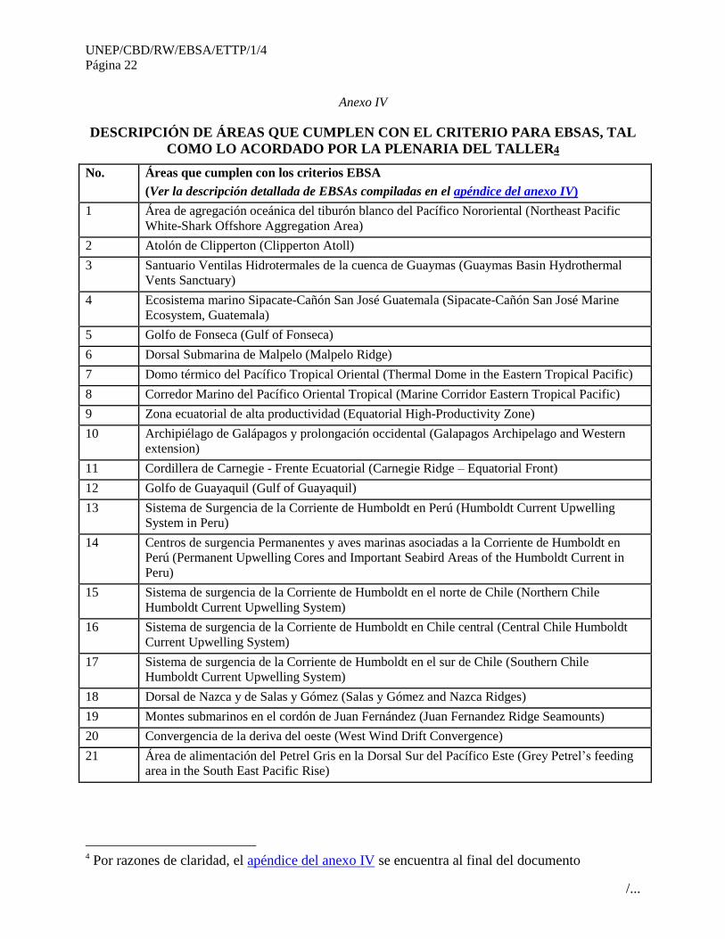
31. Los participantes del taller acordaron en las descripciones de 21 áreas que cumplen con el criterio
para las EBSAs. La descripción detallada, acordado por la plenaria, se encuentra en el anexo IV y en su
apéndice. El mapa de las áreas descritas se encuentra en el anexo V.
32. El taller reconoce que la descripción de áreas que cumplen con los criterios EBSA, fue basada en
el conocimiento de los expertos, disponible en el taller, así como en la información recopilada antes del
taller. Se reconoce que la descripción de estas áreas que cumplen con los criterios para las EBSAs
constituye una primera etapa del proceso establecido por la decisión CBD COP X/29 y se recomendó a la
Secretaría, explorar medios para la organización de talleres en el futuro, para considerar áreas potenciales
que cumplan con el criterio EBSA, conforme se vaya teniendo más información científica y conforme
aumente el conocimiento de los expertos, tal como se describe en el anexo VII.
TEMA 6. IDENTIFICACIÓN DE CARENCIAS, VACIOS DE
CONOCIMIENTOS Y NECESIDADES DE INFORMACION
PARA CONTINUAR DESCRIBIENDO LAS ÁREAS QUE
CUMPLEN LOS CRITERIOS PARA LAS EBSAS, INCLUIDA LA
NECESIDAD DE DESARROLLAR CAPACIDAD CIENTÍFICA Y
UNA PROPUESTA DE COLABORACIÓN CIENTÍFICA EN EL
FUTURO
33. Basándose en la deliberación del taller sobre la descripción de áreas que cumplen los criterios
científicos para las EBSAs, se invitó a los participantes del taller a identificar, en los grupos de trabajo y
durante deliberaciones abiertas en sesión plenaria, las carencias, vacíos de conocimientos y necesidades
de información existentes para continuar describiendo las áreas que cumplen con los criterios para las
EBSAs, incluyendo la necesidad de desarrollar capacidad científica y una propuesta de colaboración
científica en el futuro.
34. Se identificaron las siguientes necesidades:
Entrenamiento en integración de datos y conformación de redes que provean información
climática;
Fortalecimiento de los esfuerzos existentes en las redes de información;
Mejoramiento en el acceso, disponibilidad y colaboración en análisis de datos pesqueros y
monitoreo pesquero;
Entrenamiento en análisis multiespecíficos y de modelación oceánica;
UNEP/CBD/RW/EBSA/ETTP/1/4
Página 8
/...
Fortalecimiento en telemetría y monitoreo satelital de organismos pelágicos;
Mecanismo de financiamiento para continuar los estudios sobre áreas que satisfacen los criterios
de EBSA; fortalecimiento de la capacidad de información de áreas profundas;
Recabar información que otorgue sustento científico para la región mesoamericana en el Pacífico
Oriental, debido a que en la reunión del grupo 1 y la plenaria, por falta de información no se
abordó ninguna área dentro de esta región, principalmente desde el Golfo de Tehauntepec hacia
mar adentro, hasta la zona costera de Papagallo hacia mar adentro; todo en la región
mesoamericana.
35. Los resultados de las discusiones de grupo, las cuales fueron presentadas en plenaria, se
encuentran en el anexo VII.
TEMA 7. OTROS ASUNTOS
36. El Gobierno de Chile, conjuntamente con el apoyo expresado por la Secretaría de CPPS, ofreció
explorar la posibilidad de apoyar la organización de un taller de descripción de áreas que satisfagan los
criterios de EBSA para la región sub-Antártica con el objetivo de colaborar a la concreción del punto 7
del párrafo 23 de este reporte.
TEMA 8. ADOPCIÓN DEL INFORME
37. Los participantes consideraron y adoptaron el reporte del taller, basados en el proyecto de
informe elaborado y presentado por los copresidentes del taller, con algunos cambios.
38. Los participantes acordaron además que información científica y referencias científicas
adicionales pueden ser enviadas a la Secretaría a más tardar dos semanas después de la clausura del taller,
para poder afinar aún más la descripción de áreas que cumplan con los criterios EBSA que figuran en los
anexos IV y V.
TEMA 9. CLAUSURA DE LA REUNIÓN
39. Durante la clausura del taller, los copresidentes agradecieron a los participantes por sus valiosas
contribuciones durante las discusiones del taller. En nombre de la Secretaría General de CPPS, el Sr.
Fernando Félix, agradeció los aportes de los participantes, las cuales van a apoyar las decisiones futuras
sobre este tema, agradeció además a la Secretaría del CDB por el taller. En nombre del Gobierno
anfitrión, el Sr. Gustavo Iturralde, agradeció el trabajo de todos los participantes, mencionando que se
aprendió mucho en el taller y que fue una oportunidad para compartir criterios. Agradeció además a la
Secretaría General de la CPPS y a la Secretaría del CDB por la organización del taller. El Sr. David
Cooper de la Secretaría del CDB agradeció al Gobierno de Ecuador y a la Dirección del Parque Nacional
Galápagos por ser anfitriones del taller. Agradeció también a la Secretaría General de la CPPS por la
organización del taller y al equipo técnico, co-presidentes, relatores e intérpretes que apoyaron al taller.
40. El taller se clausuró a las 4.30 p.m. del viernes 31 de agosto de 2012.

UNEP/CBD/RW/EBSA/ETTP/1/4
Página 9
/...
Anexo I
LISTA DE PARTICIPANTES
PARTES DEL CDB
Chile
Sra. Beatriz Ramírez Miranda
Departamento de Biodiversidad y Áreas Protegidas
Ministerio de Medio Ambiente
Teatinos 258-254 Piso 6to
Santiago, Chile
Correo electrónico: [email protected]
Ecuador
Sr. Kruger Loor
Analista Técnico
Malecón Jaime Chávez Edif. La Aduana 1er piso
Secretaría Técnica del Mar
Manta, Ecuador
Tel.: +593 5 2629 960
Correo electrónico: [email protected]
Colombia
Sr. David Alejandro Alonso Carvajal
Coordinador
Programa de Biodiversidad y Ecosistemas Marinos-
Instituto de Investigaciones Marines y Costeras
Santa Marta, Colombia
Correo electrónico: [email protected]
El Salvador
Sr. José Enrique Barraza Sandoval
Especialista en Ecología Marina
Ministerio de Medio Ambiente y Recursos Naturales
Km 5½ Carretera a Santa Tecla
Calle y Colonia las Mercedes (Instalaciones del ISTA)
San Salvador, El Salvador
Correo electrónico: [email protected]
Web: http://www.marn.gob.sv
Costa Rica
Sr. Jorge Arturo Jiménez Ramón
Director General
Fundación MarViva
Costa Rica
Correo electrónico: [email protected]
Francia
Sr. Philippe Béarez
Muséum National d'Histoire Naturelle
France
Correo electrónico: [email protected], [email protected]
Sr. Gustavo Elías Iturralde Muñoz
Director
Normativas y Proyectos Marino Costeros
Ministerio de Medio Ambiente
Gobierno Zonal de Guayaquil, Piso 8
Av. Francisco de Orellano y Justino Congo
Guayaquil, Ecuador
Correo electrónico: [email protected];
Sra. Angélica Esther Núñez Torres
Técnica de la Dirección de Gestión y Coordinación
Marina y Costera
Subsecretaría de Gestión Marina y Costera
Ministerio de Ambiente
Guayaquil, Ecuador
Correo electrónico: [email protected]
Guatemala
Sr. Manuel Benedicto Lucas López
Subsecretario Ejecutivo
Consejo Nacional de Áreas Protegidas (CONAP)
5 Ave. 6-06 zon 1
Edificio IPM
Ciudad de Guatemala, Guatemala
Tel.: +502 2422 6700
Cel.: +502 4210 5889
Correo electrónico: [email protected];
UNEP/CBD/RW/EBSA/ETTP/1/4
Página 10
/...
Honduras
Sr. Oscar Rene Torres Palacios
Dirección de Biodiversidad
Departamento Marino Costero
Secretaria de Recursos Naturales y Ambiente
Tegucigalpa MDC , Honduras
Tel.: +504 2239 8161
Cel.: +504 9971 2703
Correo electrónico: [email protected];
[email protected]; [email protected]
México
Sra. Elva Escobar
Universidad Nacional Autónoma de México
Instituto de Ciencias del Mar y Limnología
Unidad Académica Ecología y Biodiversidad Acuática
Laboratorio Biodiversidad y Macroecología
A.P. 70-305 Cd. Universitaria
México 04510 D.F. México
Tel.: +52 55 52 622 5841
Fax: + 52 55 56 16 27 45
Correo electrónico: [email protected],
Nicaragua
Sr. Carlos Ramiro Mejía Urbina
Director de Biodiversidad
Ministerio del Ambiente y Recursos Naturales
Km 12½ Carretera Norte Aptdo.: No. 5123
Managua, Nicaragua
Tel.: +505 22 33 1173
Correo electrónico: [email protected]
Web: www.marena.gob.ni
Panamá
Sr. Juan Laurentino Maté Touriño
Asesor Científico para Asuntos Costeros Marinos
Smithsonian Tropical Research Institute
Apartado 0843-03092
Balboa Ancón, Panamá
Correo electrónico: [email protected]
Perú
Sra. Susana Cárdenas Alayza
Centro para la Sostenibilidad Ambiental,
Universidad Peruana Cayetano Heredia
Tel.: +511 626 9402 ext. 1138 , oficina
Perú
Correo electrónico: [email protected]

UNEP/CBD/RW/EBSA/ETTP/1/4
Página 11
/...
ORGANIZACIONES
BirdLife International
Sr. Ben Lascelles
Global Marine Important Bird Area Officer
Science, Policy and Information Division, BirdLife
International
BirdLife International
Wellbrook Court Girton Road
Cambridge CB3 0NA, United Kingdom of Great Britain
and Northern Ireland
Tel.: +44 (0)1223 279 842
Fax: +44 (0) 1223 277 200
E-Mail: [email protected], [email protected]
Web: http://www.birdlife.org
Comisión Permanente del Pacífico Sur (CPPS)
Sr. Héctor Huerta
Coordinador
Plan de Acción del Pacífico Sudeste
Comisión Permanente del Pacífico Sur (CPPS)
Guayaquil, Ecuador
Correo electrónico: [email protected]
Sr. Fernando Félix
Asesor
Southeast Pacific Action Plan
Comisión Permanente del Pacífico Sur (CPPS)
Guayaquil, Ecuador
Tel.: +593 4 22 1202
Fax: +593 4 222 1201
Correo electrónico: [email protected],
Sr. Marcelo Nilo
Director de Asuntos Científicos
Comisión Permanente del Pacífico Sur (CPPS)
Av. Carlos Julio Arosemena Km. 3, Complejo Alban
Borja
Edificio Classic, Piso 2
Guayaquil, Ecuador
Correo electrónico: [email protected]
Web: http://www.cpps-int.org
Conservación Internacional - Ecuador
Sr. Scott Henderson
Conservación Internacional- Ecuador
Islas Galápagos, Puerto Ayora, Ecuador
E-Mail: [email protected]
Web: www.conservation.org.ec
Corredor Marino del Pacífico Este Tropical
Sr. Germán Arturo Corzo Mora
Secretario técnico Mesa Nacional de prioridades de
Conservación
Corredor Marino del Pacífico Este Tropical
Bogotá, Colombia
Correo electrónico: [email protected]
Global Ocean Biodiversity Initiative (GOBI)
Sr. Patricio Bernal
Coordinador – Global Ocean Biodiversity Initiative
(GOBI)
UICN - Unión Internacional para la Conservación de la
Naturaleza
Paris, Francia
Correo electrónico:[email protected]
Sr. Eduardo Klein
Associate Professor
Center for Marine Biodiversity
Universidad Simon Bolivar
Caracas, Venezuela
Correoelectrónico: [email protected]
Mr. George Shillinger
Representative,
Global Ocean Biodiversity Initiative (GOBI) & Life in a
Changing Ocean (LiCO)
Director, Tag-A-Giant Fund, The Ocean Foundation
P.O. Box 52074
Pacific Grove, CA 93950
United States of America
Tel.: + 1 202-549-0987
E-Mail: [email protected]

UNEP/CBD/RW/EBSA/ETTP/1/4
Página 12
/...
Instituto de Fomento Pesquero / CPPS
Sr. Rubén Escribano
Facultad de Ciencias Naturales y Oceanográficas
Universidad de Concepción
Chile
Correo electrónico: [email protected]
Sr. Vladimir Murillo
Reserva Marina Putemún, Castro (Chiloé)
Instituto de Fomento Pesquero
Chile
Correo electrónico: [email protected],
IUCN - International Union for Conservation of
Nature (IUCN) - WCPA
Sra. Marjo Vierros
Adjunct Senior Fellow
United Nations University - Institute of Advanced
Studies
9311 Emerald Drive
Whistler, B.C. V0N 1B9 Canada
Tel.: + 604 938-1512; 604 902 0877
E-Mail: [email protected]
National Oceanic and Atmospheric Administration
(NOAA)
Sr. Daniel Palacios
Environmental Research Division
Pacific Fisheries Environmental Laboratory
Southwest Fisheries Science Center
National Oceanic and Atmospheric Administration
USA
Tel.: +1 831 658 3203
Correo electrónico: [email protected]
Pontificia Universidad Católica de Valparaíso / CPPS
Sr. Eleuterio Yáñez
Facultad de Recursos Naturales
Pontificia Universidad Católica de Valparaíso
Correo electrónico: [email protected]
South Pacific Regional Fisheries Management
Organization
Sr. Juan Rodolfo Serra Behrens
South Pacific Regional Fisheries Management
Organization
Wellington, New Zealand
Correo electrónico: [email protected]
Universidad Católica del Norte de Chile / CPPS
Sr. Enzo Acuña
Facultad de Ciencias del Mar
Departamento de Biología Marina
Universidad Católica del Norte de Chile – Sede
Coquimbo
Correo electrónico: [email protected]
WWF
Sr. Mauricio Gálvez
WWF
San Sebastián 2750/of.503 / Los Condes
Santiago, Chile
Correo electrónico: [email protected]
Sr. Eliecer Cruz
Director Ecorregional Galápagos
Galápagos, Ecuador
Tel.: +593-5 2526053
Correo electrónico: [email protected]
OBSERVADORES LOCALES
Parque Nacional Galápagos
Sr. Javier López Medina
Responsable Monitoreo y Análisis Calidad de Agua
Parque Nacional Galápagos, Ecuador
Tel.: +593 05 2521 189 ext. 136
Correo electrónico: [email protected]
Parque Nacional Galápagos
Sr. Harry Raul Reyes Mackliff
Responsable Manejo Pesquero
Parque Nacional Galápagos, Ecuador
Tel.: +593 05 2527 410 ext. 138
Correo electrónico: [email protected],
UNEP/CBD/RW/EBSA/ETTP/1/4
Página 13
/...
Sr. Eduardo Ramón Espinoza Herrera
Responsable del Departamento de Investigaciones
Marinas Aplicadas
Parque Nacional Galápagos, Ecuador
Tel.: + 593 05-2526 189 ext. 138
Correo electrónico: [email protected]
EQUIPO DE SOPORTE TÉCNICO
Mr. Patrick Halpin
Associate Professor of Marine Geospatial Ecology
Nicholas School of the Environment
Duke University
Corner of Science Drive and Towerview Road
Durham, North Carolina 27708
United States of America
Tel.: +1 919 613 8062
E-Mail: [email protected]
Mr. Jesse Cleary
Research Analyst
Marine Geospatial Ecology Lab, Nicholas School of the
Environment
Duke University
Corner of Science Drive and Towerview Road
Durham, North Carolina 27708
United States of America
E-Mail: [email protected]
Mr. Ben Donnelly
Research Analyst
Marine Geospatial Ecology Lab
Duke University
Corner of Science Drive and Towerview Road
Durham, North Carolina 27708
United States of America
E-Mail: [email protected]
Mr. Daniel Dunn
Research Associate
Marine Geospatial Ecology Lab
Duke University Marine Lab
135 Marine Lab Road
Beaufort, NC 28516
United States of America
Tel.: +1 252 504 7605
E-Mail: [email protected]
SECRETARÍA DEL CONVENIO SOBRE LA DIVERSIDAD BIOLÓGICA
Secretaría del Convenio sobre la Diversidad Biológica
Mr. David Cooper
Principal Officer
Scientific, Technical and Technological Matters
Secretariat of the Convention on Biological Diversity
413, Saint-Jacques Street W. Suite 800
Montreal, Quebec, Canada H2Y 1N9
Tel.: +1 514 287 8709
E-Mail: [email protected]
Web: www.cbd.int
Ms. Jihyun Lee
Environmental Affairs Officer for marine and coastal
biodiversity
Scientific, Technical and Technological Matters
Secretariat of the Convention on Biological Diversity
413, Saint-Jacques Street W. Suite 800
Montreal, Quebec, Canada H2Y 1N9
E-Mail: [email protected]
Web: www.cbd.int
Ms. Gisela Talamas
Programme Assistant
Secretariat of the Convention on Biological Diversity
413, Saint-Jacques Street W. Suite 800
Montreal, Quebec, Canada H2Y 1N9
Tel.: +1 514 287 6690
E-Mail: [email protected]

UNEP/CBD/RW/EBSA/ETTP/1/4
Página 14
/...
Anexo II
RESUMEN DE LAS PRESENTACIONES
Tema 3
Jihyun Lee (CBD Secretariat)
Ms. Jihyun Lee outlined the process for describing ecologically or biologically significant marine areas
(EBSAs), through which COP 10 called for regional EBSA workshops as well as the process through
SBSTTA and COP to which the outcomes of the workshops will be submitted for their consideration and
endorsement. She noted the challenges of the diverse, large-scale data, but reiterated the importance of the
process in relation to the Aichi Biodiversity Targets. She then highlighted the potential benefits of the
EBSA process in further strengthening the region’s efforts toward marine biodiversity conservation goals,
by facilitating scientific collaboration, increasing the awareness, and encouraging countries to apply
necessary conservation measures related to EBSAs. She also briefed on previous regional workshops on
EBSAs and explained the scale of data compilation undertaken.
Fernando Félix (Secretaría CPPS)
El Sr. Fernando Félix presentó la revisión de los programas científicos a escala regional. Mencionó que
la investigación marina en los países del Pacífico oriental ha estado enfocada principalmente a los
recursos pesqueros y oceanografía, predadores superiores y a la gestión de datos y que los grupos
principales de investigación incluyen instituciones nacionales, ONGs y universidades, concentrando el
esfuerzo en las zonas económicas exclusivas.
Señaló que entre las investigaciones relevantes en la región destacan los cruceros de evaluación de
cetáceos y del ecosistema en el Pacífico Oriental Tropical llevado a cabo por SWFSC – NOAA (1986-
2006), así como seguimiento satelital de elefantes marinos, ballenas azules, tortugas marinas, entre
otros, y su relación con variables ambientales. Se destacó también el apoyo de Conservación
Internacional a diferentes instituciones nacionales y ONGs en los cuatro países que conforman el
Corredor Marinos del Pacífico Este Tropical (CMAR) para llevar a cabo investigación sobre tiburones,
rayas y tortugas marinas.
En cuanto al trabajo de las organizaciones TNC y WWF, se mencionó que éstas han desarrollado un
importante trabajo para identificar las ecorregiones marinas del mundo, un sistema jerárquico basado en
configuraciones taxonómicas influenciada por la historia evolutiva, patrones de dispersión y aislamiento
de especies. WWF también ha presentado una propuesta de un área que cumple con los criterios EBSA
para las cordilleras Salas y Gómez y de Nazca en el Pacífico Sudeste. Se señaló que además de estas
organizaciones, existen también en la región, dos organismos regionales pesqueras, la Comisión
Interamericana del Atún Tropical (CIATT) y la Organización Regional para el Manejo Pesquero del
Pacífico Sur. El primero cuenta con un programa de investigación sobre ecología, evaluación de stocks,
captura incidental y descartes. La segunda entró en vigor recientemente (24 agosto 2012).
Para concluir, el Sr. Félix informó sobre las actividades en apoyo a la investigación científica que
realiza la Comisión Permanente del Pacífico Sur (CPPS) en los ámbitos biológicos, climáticos y
socioeconómicos. Entre los programas y proyectos regionales de investigación coordinado por CPPS se
destacan el de corredores y hábitats críticos de mamíferos marinos, la integración de datos científicos a
través de un sistema regional de información y los 15 cruceros regionales conjunto llevados a cabo por
los cuatro países de la región desde 1998.

UNEP/CBD/RW/EBSA/ETTP/1/4
Página 15
/...
Elva Escobar (Mexico) and Eduardo Klein (GOBI)
Ms. Elva Escobar (Mexico) provided a background and global overview of the Global Open Ocean and
Deep Seabed (GOODS) biogeographic classification system. She reviewed how GOODS classification
system can contribute to global commitments toward the ocean management, including World Summit on
Sustainable Development Plan of Implementation, Aichi Targets, and Rio+20 outcomes. She explained
also how the GOODS classification system was developed through relevant expert processes, e.g. Mexico
workshop (2007) and CBD Expert workshop in Azores (2007) and Ottawa (2009). She then provided the
details of GOODS systems to facilitate the workshop discussion on the geographic scope of the workshop.
Following the overall presentation on GOODS, Mr. Eduardo Klein (GOBI) briefed the workshop on
many relevant biogeographic classification systems of the world oceans, including Marine Ecoregions of
the World (MEOW), Global Open Ocean and Deep Seabed (GOODS) classification system, and Large
Marine Ecosystems (LMEs). He also reminded the group of the eastern boundary of the Western South
Pacific regional workshop on EBSA held in Fiji, 22-25 November 2011. He then facilitated the plenary
discussion on finalizing the workshop geographic scope.
Tema 4
Jesse Cleary (Universidad Duke)
Mr. Jesse Cleary provided a presentation on the compilation, synthesis, analysis and mapping of scientific
data available to support the work of the workshop attendees. These data were compiled in a data report
titled "Data to Inform the CBD Workshop to Facilitate the Description of Ecologically or Biologically
Significant Marine Areas in the Eastern Temperate and Tropical Pacific" by a technical support team (the
Marine Geospatial Ecology Lab at Duke University, USA and Universidad Simón Bolívar, Venezuela),
commissioned by the CBD Secretariat. The types of data discussed and presented in the report covered
biogeographic data, biological data and physical data. The data report contains a full list of over 80 layers
of data and maps for each dataset. In addition to the data report document, the data were provided to the
meeting in large format maps, in small format mapbooks, in a GIS database, and as a data package that
was distributed with an open-source GIS software to view the data.
Fernando Félix (Secretaría CPPS)
El Sr. Félix dio una presentación sobre el uso del modelo de distribución marina en la aplicación del
criterio EBSA, los cuales permiten asociar condiciones ambientales particulares a la distribución de
datos para definir el hábitat de especies migratorias o de alta movilidad, identificando áreas de
concentración, reproducción, alimentación, etc., así como de amenazas o conflictos derivados de
actividades humanas.
Como ejemplo, describió el trabajo de modelación de hábitat de cinco especies de ballenas en el
Pacífico oriental usando modelos probabilísticos. El Sr. Félix mencionó que el trabajo se realizó en
implementación del Proyecto PNUMA/España/CPPS “planificación espacial de larga escala para rutas
migratorias y hábitats críticos de mamíferos marinos en el Pacífico oriental”. Los mapas generados
proporcionan una visión general de los hábitats esenciales y rutas migratorias a escala regional para
estas especies.
El Sr. Félix señaló que dos enfoques diferentes fueron utilizados en este trabajo: predicción de densidad
e idoneidad de hábitat. En el primero se utilizó información generada durante cruceros de NOAA de
Estados Unidos entre 1986 y 2005 y modelos aditivos generalizados (GAM) para relacionar el número
de individuos a cinco variables estáticas predictoras (temperatura superficial del mar, salinidad, clorofila
a, profundidad de la capa de mezcla y distancia a la isóbata 200m). Este método fue utilizado para
obtener densidades de tres especies de ballenas: azules, jorobadas y de Bryde.

UNEP/CBD/RW/EBSA/ETTP/1/4
Página 16
/...
En el segundo caso se uso el modelo Maxent, asociando seis variables ambientales a la distribución de
datos (temperatura superficial del mar, salinidad superficial, profundidad, pendiente, clorofila a
superficial y frentes pelágicos persistentes superficiales). Este enfoque es útil cuando no se cuenta con
información de esfuerzo. Mapas fueron generados para ballenas azul, jorobada, Bryde, ballenas francas
del sur y cachalotes, para dos períodos en el año dic-mayo y jun-nov.
Ben Lascelles (BirdLife International)
Mr. Ben Lascelles briefed the workshop on the BirdLife’s Important Bird Areas (IBA) programmethat
has been used to set conservation priorities for over 30 years in terrestrial environments, and have been
used to inform the description of EBSAs.
To date over 10,000 IBAs have been identified globally, this will be supplemented in Oct 2012 by the
launch of afirst inventory of 3000 marine sites. Sites qualify when IBA criteria and thresholds are met.
For seabirds IBAs are identified for; congregations (areas holding >1% global population), threatened
species (IUCN Red Listed), biome and range restricted species. IBA criteria therefore show significant
overlap and congruence with EBSA criteria, particularly in relation to sites of importance for life history
stages and threatened species, and can therefore be used to inform the description of EBSAs. He informed
that workshop that background documents have been submitted to this workshop with further
information.
A range of seabird data has been compiled through generous contributions from seabird scientists and
submitted for consideration by this EBSA workshop. This data has been analyzed to show locations of
breeding colonies and at-sea areas where one or more EBSA criteria can be shown to have been met.
Further information can be found at www.birdlife.org.

UNEP/CBD/RW/EBSA/ETTP/1/4
Página 17
/...
Anexo III
RESUMEN DE LAS DISCUSIONES DEL TALLER SOBRE LA REVISIÓN DE LA
INFORMACIÓN/DATA/MAPAS CIENTÍFICOS RECOPILADOS PAR A EL TALLER
Grupo 1. Pacífico Este Tropical - Región México-Ecuador
El grupo recibió diez propuestas de áreas que satisfacen el criterio de EBSA para esta región.
Adicionalmente cuatro nuevas áreas fueron propuestas durante el desarrollo del taller. En todos los casos
se recibió una presentación de los proponentes y se revisó y discutió la información existente en cada
caso. Esta información fue revisada en el marco de los criterios EBSA de la CBD. Al mismo tiempo
prevaleció la decisión de aceptar sólo aquellas áreas de significancia regional que contarán con la
información técnica que sustentara esa significancia.
Dos áreas (Sipicate y Las Lisas) fueron reunidas en una sola área que extendió sus límites a la plataforma
continental, convirtiéndose en el área Sipacate-Cañon San José Guatemala.
La bahía de Jiquilisco se anexó a la propuesta de golfo de Fonseca.
De las diez propuestas recibidas antes del taller, dos propuestas (Manchón, Cóbanos) no fueron aceptados
por no tener el suficiente sustento técnico para ser consideradas áreas de significancia regional. Algunas
áreas analizadas recibieron recomendaciones específicas que se resumen en las necesidades de
capacidades (Tema 6 de la Agenda).
De las cuatro nuevas áreas propuestas durante el Taller, tres fueron aceptadas: a) Atolón de Clipperton, b)
Área de agregación oceánica del tiburón blanco del Pacífico Nororiental, c) Archipiélago de Galápagos y
prolongación occidental, d) una cuarta área (“golfo de Papagayo”) se recomendó fuera anexada al
adyacente área del “domo térmico del Pacífico Oriental” debido a sus obvias relaciones biológicas,
ecológicas e hidro-dinámicas.
Además, se consideró y complementó la propuesta del Taller regional del Pacífico Sur Occidental (Fiji), y
acordó extender la zona de alta productividad ecuatorial, así como la extensión del área que satisface los
criterios de EBSA.
Diez áreas fueran finalmente recomendadas a la Plenaria (ver Cuadro) por el grupo.
Con las nueve áreas finalmente descritas, el grupo reconoció el valor de varios procesos y fenómenos de
gran significancia biológica y ecológica:
i) Fenómenos de surgencia que ocurren al oeste de las Galápagos, el golfo de Panamá (dentro del
Corredor Marino) y el tomo térmico del Pacifíco Oriental.
ii) Ambientes submarinos, como cordilleras, montes, cañones, y ventilas hidrotermales presentes
dentro del Corredor Marino, el cañón de San José, la Dorsal Malpelo y la cuenca de Guaymas
iii) Sitios de Agregación de poblaciones de aves marinas y especies pelágicas de amplio rango, tales
como ocurre en las áreas del Café/SOFA, el domo térmico, la atolón de Clipperton y la
plataforma del golfo de Fonseca.

UNEP/CBD/RW/EBSA/ETTP/1/4
Página 18
/...
Nombre Elementos de significancia y recomendaciones
1 - Área de agregación oceánica del
tiburón blanco del Pacífico Nororiental
Elementos de significancia:
Sitio de agregación de la población del tiburón blanco del
Pacífico nororiental durante los meses de primavera a otoño
2 - Atolón de Clipperton Elementos de significancia:
Único atolón en el Pacífico oriental, la mayor concentración de
piquero enmascarado en el mundo
3 - Santuario “Ventilas Hidrotermales
de la Cuenca de Guaymas”
Elementos de significancia:
Ambiente de aguas profundas con ventilas hidrotermales sujeto a
sedimentación orgánica. Poblaciones de microrganismos de alta
profundidad.
4 - Ecosistema marino Sipacate-Cañon
San José Guatemala
Elementos de significancia:
Cañón submarino de aguas profundas y alta diversidad de
cetáceos.
5 - Golfo de Fonseca Elementos de significancia:
Sitio de anidación y migración de tortugas carey. Área de
agregación de poblaciones pelágicas de importancia.
6 - Dorsal submarina de Malpelo Elementos de significancia:
Montañas submarinas
Recomendaciones:
Estudios de dinámica de aguas y su influencia en distribución de
microrganismos.
7 - Domo Térmico del Pacífico Oriental
(incluyendo el golfo de Papagayo)
Elementos de significancia:
Alta productividad, agregaciones de ballena azul y tortugas
baulas, ambas en peligro de extinción.
Recomendaciones:
Estudiar el uso del mecanismo de circulación del Domo para
transporte otras especies.
8 - Corredor Marino del Pacífico
Oriental Tropical
Elementos de significancia:
Cadenas montañosas submarinas, sitios de afloramiento de alta
productividad y de agregación de grandes poblaciones pelágicas.
Recomendaciones:
Generar más información sobre ambientes en las dorsales.
9 - Zona ecuatorial de alta
productividad
Elementos de significancia:
Surgencia a lo largo del Ecuador conlleva a una zona con altos
niveles de productividad que son importante para la pesca de atún
y para la captura histórica del cachalote.
10 - Archipiélago de Galápagos y
prolongación occidental
Elementos de significancia:
Sitio de surgencia y de alta productividad localizada, agregación
de poblaciones de especies de alto interés para la conservación,
alto nivel de endemismo.
UNEP/CBD/RW/EBSA/ETTP/1/4
Página 19
/...
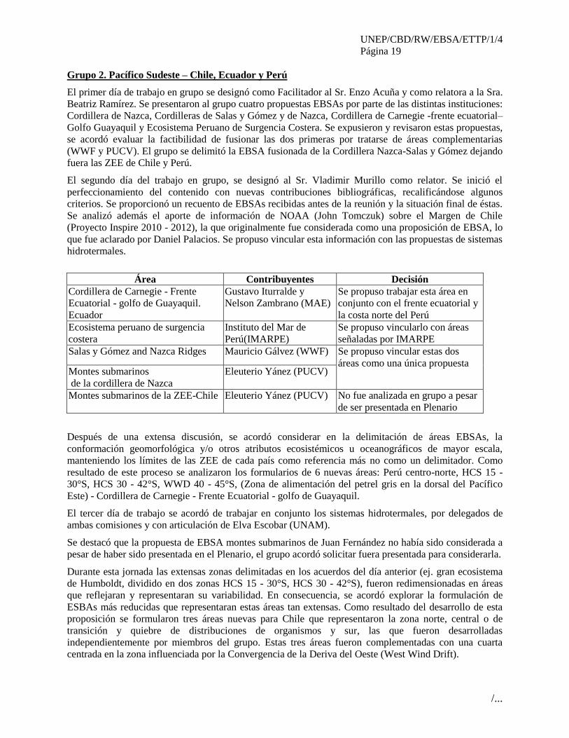
Grupo 2. Pacífico Sudeste – Chile, Ecuador y Perú
El primer día de trabajo en grupo se designó como Facilitador al Sr. Enzo Acuña y como relatora a la Sra.
Beatriz Ramírez. Se presentaron al grupo cuatro propuestas EBSAs por parte de las distintas instituciones:
Cordillera de Nazca, Cordilleras de Salas y Gómez y de Nazca, Cordillera de Carnegie -frente ecuatorial–
Golfo Guayaquil y Ecosistema Peruano de Surgencia Costera. Se expusieron y revisaron estas propuestas,
se acordó evaluar la factibilidad de fusionar las dos primeras por tratarse de áreas complementarias
(WWF y PUCV). El grupo se delimitó la EBSA fusionada de la Cordillera Nazca-Salas y Gómez dejando
fuera las ZEE de Chile y Perú.
El segundo día del trabajo en grupo, se designó al Sr. Vladimir Murillo como relator. Se inició el
perfeccionamiento del contenido con nuevas contribuciones bibliográficas, recalificándose algunos
criterios. Se proporcionó un recuento de EBSAs recibidas antes de la reunión y la situación final de éstas.
Se analizó además el aporte de información de NOAA (John Tomczuk) sobre el Margen de Chile
(Proyecto Inspire 2010 - 2012), la que originalmente fue considerada como una proposición de EBSA, lo
que fue aclarado por Daniel Palacios. Se propuso vincular esta información con las propuestas de sistemas
hidrotermales.
Después de una extensa discusión, se acordó considerar en la delimitación de áreas EBSAs, la
conformación geomorfológica y/o otros atributos ecosistémicos u oceanográficos de mayor escala,
manteniendo los límites de las ZEE de cada país como referencia más no como un delimitador. Como
resultado de este proceso se analizaron los formularios de 6 nuevas áreas: Perú centro-norte, HCS 15 -
30°S, HCS 30 - 42°S, WWD 40 - 45°S, (Zona de alimentación del petrel gris en la dorsal del Pacífico
Este) - Cordillera de Carnegie - Frente Ecuatorial - golfo de Guayaquil.
El tercer día de trabajo se acordó de trabajar en conjunto los sistemas hidrotermales, por delegados de
ambas comisiones y con articulación de Elva Escobar (UNAM).
Se destacó que la propuesta de EBSA montes submarinos de Juan Fernández no había sido considerada a
pesar de haber sido presentada en el Plenario, el grupo acordó solicitar fuera presentada para considerarla.
Durante esta jornada las extensas zonas delimitadas en los acuerdos del día anterior (ej. gran ecosistema
de Humboldt, dividido en dos zonas HCS 15 - 30°S, HCS 30 - 42°S), fueron redimensionadas en áreas
que reflejaran y representaran su variabilidad. En consecuencia, se acordó explorar la formulación de
ESBAs más reducidas que representaran estas áreas tan extensas. Como resultado del desarrollo de esta
proposición se formularon tres áreas nuevas para Chile que representaron la zona norte, central o de
transición y quiebre de distribuciones de organismos y sur, las que fueron desarrolladas
independientemente por miembros del grupo. Estas tres áreas fueron complementadas con una cuarta
centrada en la zona influenciada por la Convergencia de la Deriva del Oeste (West Wind Drift).
Área Contribuyentes Decisión
Cordillera de Carnegie - Frente
Ecuatorial - golfo de Guayaquil.
Ecuador
Gustavo Iturralde y
Nelson Zambrano (MAE)
Se propuso trabajar esta área en
conjunto con el frente ecuatorial y
la costa norte del Perú
Ecosistema peruano de surgencia
costera
Instituto del Mar de
Perú(IMARPE)
Se propuso vincularlo con áreas
señaladas por IMARPE
Salas y Gómez and Nazca Ridges Mauricio Gálvez (WWF) Se propuso vincular estas dos
áreas como una única propuesta Montes submarinos
de la cordillera de Nazca
Eleuterio Yánez (PUCV)
Montes submarinos de la ZEE-Chile Eleuterio Yánez (PUCV) No fue analizada en grupo a pesar
de ser presentada en Plenario
UNEP/CBD/RW/EBSA/ETTP/1/4
Página 20
/...
Se acogió la presentación por Ecuador de una nueva área EBSA que se relacionaba específicamente con
el golfo de Guayaquil.
Perú presentó una EBSA denominada Sistema Peruano de Afloramiento de la Corriente de Humboldt –
con énfasis en seis puntos de afloramiento. Se discutió en la plenaria esta EBSA con un área grande y a
demás con puntos focales dentro de la misma EBSA que causaba confusión, por lo cual se solicitó que
éstas fuesen separadas. Dado esto, Perú dividió su propuesta en dos EBSAs:
1. Sistema peruano de afloramiento de la Corriente de Humboldt/ Peruvian Humboldt Current Upwelling
System
2. Centros de surgencia permanentes y aves marinas asociadas del HCS - Perú / Permanent Upwelling
Cores and Important Seabird Areas of the HCS – Peru.
Otros comentarios
Se dejó constancia que cada país es soberano en la toma de acciones dentro de sus ZEE y se expresó que
desde el punto de vista legal, las determinaciones que se tomen en esta reunión no son vinculantes para
los países miembros.
Se señaló que se está aplicando el enfoque ecosistémico en grandes áreas (e.g. sistema de Humboldt),
para evitar una recepción negativa al interior de los países, por lo que sugiere redimensionar y priorizar
ciertas áreas. También uniformar los criterios para que las EBSAs que sugiera el grupo sean robustas en
su justificación.
Finalmente, el grupo acordó que las áreas propuestas y analizadas en su interior satisfacen los criterios
EBSA.
UNEP/CBD/RW/EBSA/ETTP/1/4
Página 21
/...
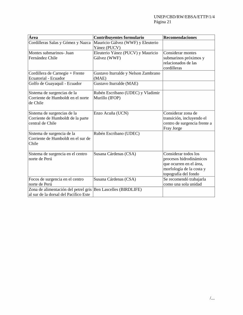
Área Contribuyentes formulario Recomendaciones
Cordilleras Salas y Gómez y Nazca Mauricio Gálvez (WWF) y Eleuterio
Yánez (PUCV)
Montes submarinos- Juan
Fernández Chile
Eleuterio Yánez (PUCV) y Mauricio
Gálvez (WWF)
Considerar montes
submarinos próximos y
relacionados de las
cordilleras
Cordillera de Carnegie + Frente
Ecuatorial - Ecuador
Gustavo Iturralde y Nelson Zambrano
(MAE)
Golfo de Guayaquil - Ecuador Gustavo Iturralde (MAE)
Sistema de surgencias de la
Corriente de Humboldt en el norte
de Chile
Rubén Escribano (UDEC) y Vladimir
Murillo (IFOP)
Sistema de surgencias de la
Corriente de Humboldt de la parte
central de Chile
Enzo Acuña (UCN) Considerar zona de
transición, incluyendo el
centro de surgencia frente a
Fray Jorge
Sistema de surgencia de la
Corriente de Humboldt en el sur de
Chile
Rubén Escribano (UDEC)
Sistema de surgencia en el centro
norte de Perú
Susana Cárdenas (CSA) Considerar todos los
procesos hidrodinámicos
que ocurren en el área,
morfología de la costa y
topografía del fondo
Focos de surgencia en el centro
norte de Perú
Susana Cárdenas (CSA) Se recomendó trabajarla
como una sola unidad
Zona de alimentación del petrel gris
al sur de la dorsal del Pacífico Este
Ben Lascelles (BIRDLIFE)
UNEP/CBD/RW/EBSA/ETTP/1/4
Página 22
/...
Anexo IV
DESCRIPCIÓN DE ÁREAS QUE CUMPLEN CON EL CRITERIO PARA EBSAS, TAL
COMO LO ACORDADO POR LA PLENARIA DEL TALLER4
4 Por razones de claridad, el apéndice del anexo IV se encuentra al final del documento
No. Áreas que cumplen con los criterios EBSA
(Ver la descripción detallada de EBSAs compiladas en el apéndice del anexo IV)
1 Área de agregación oceánica del tiburón blanco del Pacífico Nororiental (Northeast Pacific
White-Shark Offshore Aggregation Area)
2 Atolón de Clipperton (Clipperton Atoll)
3 Santuario Ventilas Hidrotermales de la cuenca de Guaymas (Guaymas Basin Hydrothermal
Vents Sanctuary)
4 Ecosistema marino Sipacate-Cañón San José Guatemala (Sipacate-Cañón San José Marine
Ecosystem, Guatemala)
5 Golfo de Fonseca (Gulf of Fonseca)
6 Dorsal Submarina de Malpelo (Malpelo Ridge)
7 Domo térmico del Pacífico Tropical Oriental (Thermal Dome in the Eastern Tropical Pacific)
8 Corredor Marino del Pacífico Oriental Tropical (Marine Corridor Eastern Tropical Pacific)
9 Zona ecuatorial de alta productividad (Equatorial High-Productivity Zone)
10 Archipiélago de Galápagos y prolongación occidental (Galapagos Archipelago and Western
extension)
11 Cordillera de Carnegie - Frente Ecuatorial (Carnegie Ridge – Equatorial Front)
12 Golfo de Guayaquil (Gulf of Guayaquil)
13 Sistema de Surgencia de la Corriente de Humboldt en Perú (Humboldt Current Upwelling
System in Peru)
14 Centros de surgencia Permanentes y aves marinas asociadas a la Corriente de Humboldt en
Perú (Permanent Upwelling Cores and Important Seabird Areas of the Humboldt Current in
Peru)
15 Sistema de surgencia de la Corriente de Humboldt en el norte de Chile (Northern Chile
Humboldt Current Upwelling System)
16 Sistema de surgencia de la Corriente de Humboldt en Chile central (Central Chile Humboldt
Current Upwelling System)
17 Sistema de surgencia de la Corriente de Humboldt en el sur de Chile (Southern Chile
Humboldt Current Upwelling System)
18 Dorsal de Nazca y de Salas y Gómez (Salas y Gómez and Nazca Ridges)
19 Montes submarinos en el cordón de Juan Fernández (Juan Fernandez Ridge Seamounts)
20 Convergencia de la deriva del oeste (West Wind Drift Convergence)
21 Área de alimentación del Petrel Gris en la Dorsal Sur del Pacífico Este (Grey Petrel’s feeding
area in the South East Pacific Rise)

UNEP/CBD/RW/EBSA/ETTP/1/4
Página 23
/...
Anexo V
MAPA DEL ALCANCE GEOGRÁFICO DEL TALLER Y ÁREAS QUE CUMPLEN LOS
CRITERIOS DE EBSA EN LA REGIÓN DEL PACÍFICO ORIENTAL TROPICAL Y
TEMPLADO, TAL COMO ACORDADO EN LA PLENARIA DEL TALLER

UNEP/CBD/RW/EBSA/ETTP/1/4
Página 24
/...
Nota: La línea azul representa el alcance geográfico del taller y la línea roja representa las áreas que
satisfacen los criterios EBSA, descritos en el apéndice del anexo IV. Los nombres de estas áreas se
encuentran en el anexo IV; los números en el mapa corresponden a los números en el cudro del anexo IV.
Anexo VI
ÁREAS CONSIDERARAS DURANTE EL TALLER PARA EL FUTURO, PERO
NO DESCRITAS PARA LOS CRITERIOS DE EBSA DEBIDO A LA ESCASEZ DE
DATOS Y/O A LA FALTA DE ANÁLISIS
No. Áreas para una futura consideracion
1 Ocos-Manchón Guamuchal (Ocos-Manchón Guamuchal)
2 Fosa de Centroamérica sector Tehuantepec-Papagayo (Central Trench Tehuantepec-
Papagayo sector)
3 La piscina cálida del Pacífico tropical oriental (The Eastern Tropical Pacific Warm Pool )
4 Áreas de alimentación de aves marinas alrededor de Diego Ramírez (Sea bird feeding areas
around Diego Ramirez)
5 Giro del Pacífico Sur Central (Central South Pacific Gyre)
6 Zona de convergencia subtropical (Subtropical Convergence Zone)
7 Ventilas hidrotermales e infiltraciones de metano del Pacífico Oriental (Hydrothermal
vents and methane infiltrations in the Eastern Pacific)
8 Punta Coles en Perú (Punta Coles, Peru)
Apéndice del anexo VI
DESCRIPCIÓN DE ÁREAS CONSIDERARAS DURANTE EL TALLER PERO NO DESCRITAS
PARA LOS CRITERIOS DE EBSA DEBIDO A LA ESCASEZ DE DATOS Y/O A LA FALTA DE
ANÁLISIS
Área no. 1 para una futura consideración: Ocos-Manchón Guamuchal
(Ocos-Manchón Guamuchal)
Área con alta diversidad, presencia de aves pelágicas y ecosistema manglar diverso único costero-marino
a nivel mesoamericano
Área no. 2 para una futura consideración: Fosa de Centroamérica sector Tehuantepec-Papagallo
(Central Trench Tehuantepec-Papagayo sector)
Zona caracterizada por 2 puntos de alta surgencia (golfo de Tehuantepec y golfo de Papagallo),
interconectada por el segmento de mayor profundidad de la fosa de centroamérica y presencia de llanos
marinos.

UNEP/CBD/RW/EBSA/ETTP/1/4
Página 25
/...
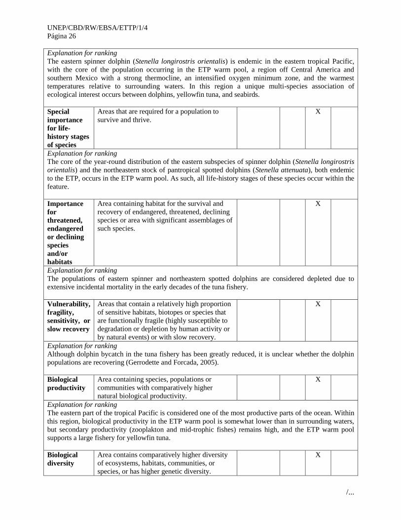
Área no. 3 para una futura consideración: La piscina cálida del Pacífico tropical oriental
(The Eastern Tropical Pacific Warm Pool)
Abstract
The Eastern Tropical Pacific warm pool is a distinct body of water characterized by a strong and shallow
pynocline and a strong oxygen minimum layer. The unique oceanography of the area has led to
multispecies associations of tunas, seabirds and dolphins, and these associations have been used by
fishermen as the basis of a purse-seine fishery for yellowfin tuna. The eastern subspecies of spinner
dolphin (Stenella longirostris orientalis) and the northeastern stock of pantropical spotted dolphins
(Stenella attenuata), endemic to the ETP warm pool, suffered heavy mortality in earlier decades of the
fishery (the “tuna-dolphin” issue). Although dolphin bycatch has been greatly reduced, it is unclear
whether the dolphin populations are recovering.
Introduction
The ETP is a marine region with a high rate of endemism. Its unique oceanographic characteristics have
led to, or at least contribute, multispecies feeding aggregations of tunas (primarily yellowfin), seabirds
(primarily boobies), and dolphins (primarily spotted and spinner). The seabirds take advantage of prey
fish driven to the surface by foraging tunas. The highly visible aggregations are used by fishermen to
locate and catch schools of yellowfin tuna. However, the fishery has also caused substantial dolphin
bycatch. The “tuna-dolphin issue” has been a high-profile conservation issue for decades, and controversy
continues today over the Dolphin-Safe label.
Roughly from 10-20° N latitude and from 110°W longitude to the coast of Central America. A portion of
this area, maybe 1/5, is in EEZ of Mexico and other Central American countries and the rest is in
international waters.
Feature description of the proposed area
To be addressed and described at a future venue.
Feature condition and future outlook of the proposed area
To be addressed and described at a future venue.
Assessment of the area against CBD EBSA Criteria
CBD EBSA
Criteria
(Annex I to
decision
IX/20)
Description
(Annex I to decision IX/20) Ranking of criterion relevance
Don’t
Know
Low Some High
Uniqueness
or rarity
Area contains either (i) unique (“the only one
of its kind”), rare (occurs only in few
locations) or endemic species, populations or
communities, and/or (ii) unique, rare or
distinct, habitats or ecosystems; and/or (iii)
unique or unusual geomorphological or
oceanographic features.
X
UNEP/CBD/RW/EBSA/ETTP/1/4
Página 26
/...
Explanation for ranking
The eastern spinner dolphin (Stenella longirostris orientalis) is endemic in the eastern tropical Pacific,
with the core of the population occurring in the ETP warm pool, a region off Central America and
southern Mexico with a strong thermocline, an intensified oxygen minimum zone, and the warmest
temperatures relative to surrounding waters. In this region a unique multi-species association of
ecological interest occurs between dolphins, yellowfin tuna, and seabirds.
Special
importance
for life-
history stages
of species
Areas that are required for a population to
survive and thrive. X
Explanation for ranking
The core of the year-round distribution of the eastern subspecies of spinner dolphin (Stenella longirostris
orientalis) and the northeastern stock of pantropical spotted dolphins (Stenella attenuata), both endemic
to the ETP, occurs in the ETP warm pool. As such, all life-history stages of these species occur within the
feature.
Importance
for
threatened,
endangered
or declining
species
and/or
habitats
Area containing habitat for the survival and
recovery of endangered, threatened, declining
species or area with significant assemblages of
such species.
X
Explanation for ranking
The populations of eastern spinner and northeastern spotted dolphins are considered depleted due to
extensive incidental mortality in the early decades of the tuna fishery.
Vulnerability,
fragility,
sensitivity, or
slow recovery
Areas that contain a relatively high proportion
of sensitive habitats, biotopes or species that
are functionally fragile (highly susceptible to
degradation or depletion by human activity or
by natural events) or with slow recovery.
X
Explanation for ranking
Although dolphin bycatch in the tuna fishery has been greatly reduced, it is unclear whether the dolphin
populations are recovering (Gerrodette and Forcada, 2005).
Biological
productivity
Area containing species, populations or
communities with comparatively higher
natural biological productivity.
X
Explanation for ranking
The eastern part of the tropical Pacific is considered one of the most productive parts of the ocean. Within
this region, biological productivity in the ETP warm pool is somewhat lower than in surrounding waters,
but secondary productivity (zooplakton and mid-trophic fishes) remains high, and the ETP warm pool
supports a large fishery for yellowfin tuna.
Biological
diversity
Area contains comparatively higher diversity
of ecosystems, habitats, communities, or
species, or has higher genetic diversity.
X
UNEP/CBD/RW/EBSA/ETTP/1/4
Página 27
/...
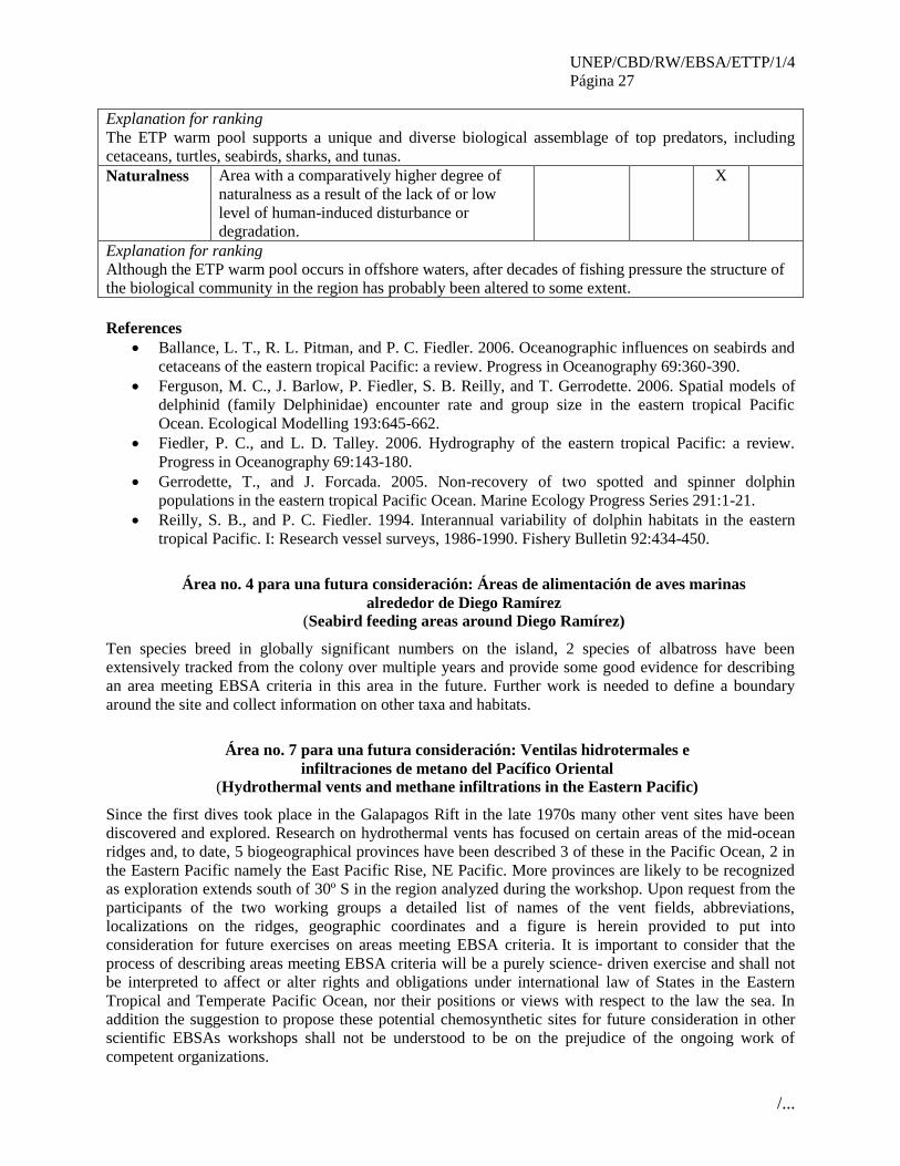
Explanation for ranking
The ETP warm pool supports a unique and diverse biological assemblage of top predators, including
cetaceans, turtles, seabirds, sharks, and tunas.
Naturalness Area with a comparatively higher degree of
naturalness as a result of the lack of or low
level of human-induced disturbance or
degradation.
X
Explanation for ranking
Although the ETP warm pool occurs in offshore waters, after decades of fishing pressure the structure of
the biological community in the region has probably been altered to some extent.
References
Ballance, L. T., R. L. Pitman, and P. C. Fiedler. 2006. Oceanographic influences on seabirds and
cetaceans of the eastern tropical Pacific: a review. Progress in Oceanography 69:360-390.
Ferguson, M. C., J. Barlow, P. Fiedler, S. B. Reilly, and T. Gerrodette. 2006. Spatial models of
delphinid (family Delphinidae) encounter rate and group size in the eastern tropical Pacific
Ocean. Ecological Modelling 193:645-662.
Fiedler, P. C., and L. D. Talley. 2006. Hydrography of the eastern tropical Pacific: a review.
Progress in Oceanography 69:143-180.
Gerrodette, T., and J. Forcada. 2005. Non-recovery of two spotted and spinner dolphin
populations in the eastern tropical Pacific Ocean. Marine Ecology Progress Series 291:1-21.
Reilly, S. B., and P. C. Fiedler. 1994. Interannual variability of dolphin habitats in the eastern
tropical Pacific. I: Research vessel surveys, 1986-1990. Fishery Bulletin 92:434-450.
Área no. 4 para una futura consideración: Áreas de alimentación de aves marinas
alrededor de Diego Ramírez (Seabird feeding areas around Diego Ramírez)
Ten species breed in globally significant numbers on the island, 2 species of albatross have been
extensively tracked from the colony over multiple years and provide some good evidence for describing
an area meeting EBSA criteria in this area in the future. Further work is needed to define a boundary
around the site and collect information on other taxa and habitats.
Área no. 7 para una futura consideración: Ventilas hidrotermales e
infiltraciones de metano del Pacífico Oriental (Hydrothermal vents and methane infiltrations in the Eastern Pacific)
Since the first dives took place in the Galapagos Rift in the late 1970s many other vent sites have been
discovered and explored. Research on hydrothermal vents has focused on certain areas of the mid-ocean
ridges and, to date, 5 biogeographical provinces have been described 3 of these in the Pacific Ocean, 2 in
the Eastern Pacific namely the East Pacific Rise, NE Pacific. More provinces are likely to be recognized
as exploration extends south of 30º S in the region analyzed during the workshop. Upon request from the
participants of the two working groups a detailed list of names of the vent fields, abbreviations,
localizations on the ridges, geographic coordinates and a figure is herein provided to put into
consideration for future exercises on areas meeting EBSA criteria. It is important to consider that the
process of describing areas meeting EBSA criteria will be a purely science- driven exercise and shall not
be interpreted to affect or alter rights and obligations under international law of States in the Eastern
Tropical and Temperate Pacific Ocean, nor their positions or views with respect to the law the sea. In
addition the suggestion to propose these potential chemosynthetic sites for future consideration in other
scientific EBSAs workshops shall not be understood to be on the prejudice of the ongoing work of
competent organizations.

UNEP/CBD/RW/EBSA/ETTP/1/4
Página 28
/...
The species diversity in chemosynthetic communities is maintained by habitat heterogeneity manifested
as topographic features, geochemical gradients generated by subsurface fluid seepage or degradation of
organic inputs in addition to upwelling production or hydrographic features in the water column. Several
of these features come together along much of the eastern Pacific margin to create environments
characterized by oxygen depletion and methane seepage. On ridge crests, vent habitats are distributed
linearly as small mixing cells between hot fluids and seawater, occurring at irregular intervals.
Discontinuities of the ridges, as well as hydrological barriers, limit the along-axis dispersal and favor
speciation.
Diverse biogeographic models of vent faunas have been suggested considering correlations between the
provinces recognized and the geographical locations of the ocean basins, the degrees of isolation, the
bathymetry and vicariance events. These recognized the fact that the East Pacific Rise and the northeast
Pacific ridge system once formed a continuous plate boundary that was split. This existing knowledge and
above points of view support the need to propose locations that should be considered in the future as
potential areas meeting EBSA criteria within the area of scope of this workshop in the East Pacific,
including the little-explored zones along the SE Pacific. The southern oceans are in general the less
studied regions for deep-water chemosynthetic sites. The Chile Rise for vents; and the continental
margins of Peru and Chile for seeps are crucial for better understanding this highly productive
chemosynthetic systems.
Other arguments to support this proposal include the large chemosynthetic production, the distribution of
species, their reproductive patterns and larval characteristics that are of special interest in hydrothermal
vents and cold seeps. The future exploration of new areas will assist in the discovery of new vent and seep
sites and their diversity and endemicity of the fauna. n of new species and improve our understanding of
the abundance, diversity, and distribution of species from chemosynthetically-driven systems.
UNEP/CBD/RW/EBSA/ETTP/1/4
Página 29
/...
Anexo VII
RESUMEN DE LAS DISCUSIONES DEL TALLER SOBRE LA IDENTIFICACIÓN DE
CARENCIAS, VACÍOS DE CONOCIMIENTOS Y NECESIDADES DE INFORMACIÓN
PARA CONTINUAR DESCRIBIENDO LAS ÁREAS QUE CUMPLEN CON LOS
CRITERIOS PARA LAS EBSAS, INCLUYENDO LA NECESIDAD DE DESARROLLAR
CAPACIDAD CIENTÍFICA Y UNA PROPUESTA DE COLABORACIÓN CIENTÍFICA
EN EL FUTURO
Grupo 1. Pacífico Este Tropical - Región México-Ecuador
Los participantes del grupo de trabajo identificaron los siguientes vacíos y necesidades para esta
subregión:
Fortalecer las investigaciones sobre patrones de distribución de especies pelágicas y altamente
migratorias, tanto de aquellas con importancia comercial como para la conservación;
Fortalecer las investigaciones oceanográficas y de los fondos marinos, particularmente aquellos
fondos profundos en los montes submarinos;
Mejorar el conocimiento y la capacidad predictiva del fenómeno de El Niño en la región;
Fortalecer programas de intercambio científico;
Fomentar el desarrollo de capacidades en 1) oceanografía biológica, física y química; 2)
taxonomía de peces e invertebrados marinos pelágicos y costeros; 3) bentos de fondos costeros y
de mayor profundidad; 4) modelación de corrientes, entre otros;
Organizar talleres para científicos y tomadores de decisiones en el área del Pacífico Tropical
Oriental, para promover la gestión unificada de información a fin de mejorar la gestión de los
recursos costeros y marinos,;
Realizar ejercicios de modelación de escenarios frente al cambio climático;
Desarrollar estudios de línea base de la situación de los recursos marinos y costeros y realizar
análisis de conectividad entre zonas costeras y zonas bentonitas y pelágicas;
Promover la cooperación en la investigación marina, diseminar información en la web y
promover el uso de herramientas gratuitas para el análisis de datos;
Conducir investigación en la región profunda de esta región;
Promover el intercambio de experiencias entre los equipos de investigación de diferentes países y
optimizar los recursos financieros y técnicos;
Llena los vacíos de la conectividad ecológica en los diferentes niveles (por ejemplo,
oceanográfico, genética, etc.) Esto ayudaría a entender la importancia de algunas áreas que
satisfagan los criterios EBSA, para identificar necesidades y para justificar la descripción de
estas.
Grupo 2. Pacífico Sudeste – Chile, Ecuador y Perú
En general, el grupo consideró que se requieren estudios de línea base biológica para áreas que sufren de
alto impacto, particularmente las que están en la zona costera.
UNEP/CBD/RW/EBSA/ETTP/1/4
Página 30
/...
Cordilleras Salas y Gómez y Nazca
Vacíos
El grupo notó que existe poca información in situ, no hay inventarios completos de biodiversidad.
Análisis de información satelital formal (variabilidad interanual, estacional e interdecadal), temperatura
para estimar frentes, análisis de profundidad, productividad primaria.
Se requiere información pesquera tanto de la Comisión Interamericana del Atún Tropical (CIAT) como de
Organización Regional para el Manejo Pesquero del Pacífico Sur. Análisis de los vínculos entre la
información bentónica y pelágica con respecto a la estructura y funcionamiento y flujos de carbono
vertical. Se pide mantener un sistema de observación de la zona.
Necesidades de desarrollo de capacidades
Se sugirió la implementación de marcajes satelitales sobre aves y mamíferos marinos. Potenciar la gestión
de datos e información. Entrenamiento en taxonomía, particularmente de nidarios y otros invertebrados
bentónicos.
Colaboración científica
El grupo notó la necesidad de vincular el proceso EBSA con el proceso regular de evaluación de las
Naciones Unidas. Considerar rutas navieras y transporte marítimo para ajustar el criterio naturalidad, para
lo que se requiere consultas con la Organización Marítima Internacional (OMI). Incrementar el área de
cobertura de los cruceros regionales coordinados por CPPS para el estudio y monitoreo científico de ésta
EBSA y su potencial respuesta a la variabilidad climática. Mucha información de esta zona fue obtenida
por campañas científicas de la ex URSS, por lo que está en ruso y se requiere ayuda para su traducción.
Sistema Peruano de Afloramiento de la Corriente de Humboldt
Vacíos
El grupo identificó como vacío, estudios sobre conectividad e interacción del sistema de surgencias con el
sistema abisal y elmesopelágico en la trinchera. Modelación bioclimática del sistema de surgencias de
esta parte de la Corriente de Humboldt (impacto de cambio climático). Evaluar el impacto de los procesos
de eutrofización que producen mareas rojas en la costa peruana. Evaluar poblaciones de predadores
superiores tanto residentes como transitorios (e.g. delfines, tiburones, tortugas, etc.). Evaluar los cañones
submarinos presentes en esta área.
Necesidades de desarrollo de capacidades
El grupo notó la necesidad de entrenamiento superior en ciencias marinas. Desarrollo de protocolos
estandarizados para toma de muestras biológicas (genética, contaminantes, enfermedades, etc). Estudios
de línea base de salud poblacional y dispersión de depredadores superiores.
Colaboración científica
Priorizar líneas de investigación y acción a través del reconocimiento de las capacidades actuales de los
diferentes grupos de investigación (gubernamental., ONGs, universidades, etc.) fueron consideradas por
el grupo, así como la necesidad de articular un trabajo en red. Incrementar la colaboración con expertos
de los países vecinos y fuera de la región para entender mejor las interacciones ecológicas de esta zona.

UNEP/CBD/RW/EBSA/ETTP/1/4
Página 31
/...
Centros de Surgencia Permanentes y aves marinas asociadas del HCS -Perú
Vacíos
Evaluar poblaciones de predadores superiores residentes, con especial énfasis en la conectividad entre los
centros de surgencia (e.g. marcaje y seguimiento de aves guaneras, lobos marinos y pingüinos). Evaluar la
relación de los predadores transitorios (e.g. aves migratorias, delfines, tiburones, tortugas, etc.) en
relación a estos centros. El grupo recomienda buscar la forma de más dinámica de delimitación del
EBSA. Monitorear los centros de surgencia en red de manera permanente para entender la variabilidad en
la respuesta de estos sitios cuando hay condiciones ambientales variables.
Necesidades de desarrollo de capacidades
Incrementar la colaboración con expertos de los países vecinos y de fuera de la región para poder aplicar
la mejor metodología y tecnología para entender mejor las interacciones ecológicas entre los centros de
surgencias y la biodiversidad,
Colaboración científica
Generar un sistema de colaboración en red a lo largo de los centros de surgencia entre diferentes
instituciones para poder hacer un monitoreo simultáneo de los mismos y del comportamiento de las aves
marinas en relación a estos.
Área de alimentación del petrel gris en la dorsal del Pacífico sur
Vacíos
El grupo notó como vacío la genética para identificar si se trata de una subespecie o población particular
(discrete) del petrel gris (Procelaria cinerea). Más estudios ecológicos para entender mejor los procesos
ecológicos que se dan esta área. Mayores esfuerzos de marcación satelital de otras especies de aves (eg.
petreles, albatros) para determinar si ocurren aquí.
Colaboración científica
Se reconoció la necesidad de incrementar esfuerzos de investigación con la Comisión Interamericana del
Atún Tropical (CIATT) y la Organización Regional para el Manejo Pesquero del Pacífico Sur.
Frente ecuatorial-Cordillera de Carnegie y Golfo de Guayaquil
Vacíos
Se mencionó que en la cordillera falta información biológica abisal-demersal y bentónica pues se conoce
solo geomorfología y sedimentos. Se requiere además investigación sobre contaminantes provenientes de
la zona costera, particularmente del estuario en el golfo de Guayaquil.
El grupo identificó que para el golfo de Guayaquil se necesita investigación sobre especies pelágicas no
comerciales a ambos lados del Frente Ecuatorial. Determinar el estado de las pesquerías, así como evaluar
el impacto por actividades humanas, incluyendo actividades pesqueras, tráfico marítimo, acuacultura y
contaminación (química, nutrientes, hidrocarburos). Estudios poblacionales de interés para la
conservación.
Necesidades de desarrollo de capacidades
El grupo identificó el diseño y administración de bases de datos. Entrenamiento en taxonomía, notaron
además que se requieren más especialistas en ecología marina.

UNEP/CBD/RW/EBSA/ETTP/1/4
Página 32
/…
Cordón de montes submarinos Juan Fernández
Vacíos
Se reconoce la falta de estudios más comprehensivos para estimar la biodiversidad. Aumentar
colaboración para fortalecer el monitoreo oceanográfico-biológico in situ.
Ecosistemas de Humboldt, área sur. Aplica para las áreas centro y norte.
Vacíos y necesidades de investigación
Oceanografía:
El grupo identificó que se requieren investigaciones sobre la interacción océano-atmósfera, así como
estudios costa afuera y en ecosistemas de mínimo oxígeno, tanto dentro como fuera de la costa. En la
zona costera evaluar la relación con relación al acople béntico-pelágico.
Biológico/pesquero:
El grupo identificó que hace falta intensificar la investigación en los ecosistemas del talud continental, de
aguas profundas y abisales, en relación con la capacidad de resiliencia al cambio climático.
Entrenamiento en taxonomía. Estudios de genética poblacional para definir la estructura de las
poblaciones y su relación filogenética con otras áreas núcleo del sistema de la Corriente de Humboldt.
Evaluar el impacto de la introducción de especies invasoras para acuacultura y tal vez por agua de lastre.

UNEP/CBD/RW/EBSA/ETTP/1/4
Página 33
/…
APÉNDICE DEL ANEXO IV DEL REPORTE
DESCRIPCIÓN DE ÁREAS QUE CUMPLEN CON EL CRITERIO PARA EBSAS, TAL COMO
LO ACORDADO POR LA PLENARIA DEL TALLER 5,6
TABLE OF CONTENTS
ÁREA NO. 1: ÁREA DE AGREGACIÓN OCEÁNICA DEL TIBURÓN BLANCO DEL PACIFICO NORORIENTAL ................................................................................................................................................................ 35
(NORTHEAST PACIFIC WHITE SHARK OFFSHORE AGGREGATION AREA) .......................................... 35
ÁREA NO. 2: ATOLÓN DE CLIPPERTON .................................................................................................. 44
(CLIPPERTON ATOLL) .......................................................................................................................... 44
ÁREA NO. 3: SANTUARIO VENTILAS HIDROTERMALES DE LA CUENCA DE GUAYMAS ........................ 53
(GUAYMAS BASIN HYDROTHERMAL VENTS SANCTUARY) ............................................................... 53
ÁREA NO. 4: ECOSISTEMA MARINO SIPACATE-CAÑÓN SAN JOSÉ GUATEMALA ................................. 71
(SIPICATE-CAÑON SAN JOSE MARINE ECOSYSTEM, GUATEMALA) .................................................. 71
ÁREA NO. 5: GOLFO DE FONSECA .......................................................................................................... 92
(GULF OF FONSECA)............................................................................................................................ 92
ÁREA NO. 6: DORSAL SUBMARINA DE MALPELO ................................................................................ 100
(MALPELO RIDGE) ............................................................................................................................. 100
ÁREA NO. 7: DOMO TÉRMICO DEL PACIFICO TROPICAL ORIENTAL ................................................... 109
(THERMAL DOME IN THE EASTERN TROPICAL PACIFIC) ...................... Error! Bookmark not defined.
ÁREA NO. 8: CORREDOR MARINO DEL PACIFICO ORIENTAL TROPICAL ............................................. 130
(MARINE CORRIDOR EASTERN TROPICAL PACIFIC) ......................................................................... 130
ÁREA NO. 9: ZONA ECUATORIAL DE ALTA PRODUCTIVIDAD .............................................................. 141
(EQUATORIAL HIGH-PRODUCTIVITY ZONE) ..................................................................................... 141
ÁREA NO. 10: ARCHIPIÉLAGO DE GALÁPAGOS Y PROLONGACIÓN OCCIDENTAL .............................. 147
(GALAPAGOS ARCHIPELAGO AND WESTERN EXTENSION) ............................................................. 147
ÁREA NO. 11: CORDILLERA DE CARNEGIE – FRENTE ECUATORIAL ..................................................... 158
5 Este material se presenta en la forma e idioma en el que fue sometido a la Secretaría.
6 Las denominaciones empleadas y la forma en que se presentan los datos en este anexo no
suponen la expresión de opinión alguna de la Secretaría, sea cual fuere, con respecto a la
situación jurídica de ningún país, territorio, ciudad o zona o sus autoridades, ni con respecto a la
delimitación de sus fronteras o límites.
UNEP/CBD/RW/EBSA/ETTP/1/4
Página 34
/…
(CARNEGIE RIDGE – EQUATORIAL FRONT) ...................................................................................... 158
ÁREA NO. 12: GOLFO DE GUAYAQUIL ................................................................................................. 169
(GULF OF GUAYAQUIL) ..................................................................................................................... 169
ÁREA NO. 13: SISTEMA DE SURGENCIA DE LA CORRIENTE HUMBOLDT EN PERÚ ............................. 181
(HUMBOLDT CURRENT UPWELLING SYSTEM IN PERU) .................................................................. 181
ÁREA NO. 14: CENTROS DE SURGENCIA PERMANENTES Y AVES MARINAS ASOCIADAS A LA CORRIENTE DE HUMBOLDT EN PERÚ .................................................................................................. 190
(PERMANENT UPWELLING CORES AND IMPORTANT SEABIRD AREAS OF THE HUMBOLDT
CURRENT IN PERU) ........................................................................................................................... 190
ÁREA NO. 15: SISTEMA DE SURGENCIA DE LA CORRIENTE DE HUMBOLDT EN EL NORTE DE CHILE . 198
(NORTHERN CHILE HUMBOLDT CURRENT UPWELLING SYSTEM) ................................................... 198
ÁREA NO. 16: SISTEMA DE SURGENCIA DE LA CORRIENTE DE HUMBOLDT EN CHILE CENTRAL ....... 205
(CENTRAL CHILE HUMBOLDT CURRENT UPWELLING SYSTEM) ....................................................... 205
ÁREA NO. 17: SISTEMA DE SURGENCIADE LA CORRIENTE DE HUMBOLDT EN EL SUR DE CHILE ...... 211
(SOUTHERN CHILE HUMBOLDT CURRENT UPWELLING SYSTEM) ................................................... 211
ÁREA NO. 18: DORSAL DE NAZCA Y DE SALAS Y GÓMEZ .................................................................... 217
(SALAS Y GÓMEZ AND NAZCA RIDGES) ........................................................................................... 217
ÁREA NO. 19: MONTES SUBMARINOS EN EL CORDÓN DE JUAN FERNÁNDEZ ................................... 224
(JUAN FERNANDEZ RIDGE SEAMOUNTS) ........................................................................................ 224
ÁREA NO. 20: CONVERGENCIA DE LA DERIVA DEL OESTE .................................................................. 231
(WEST WIND DRIFT CONVERGENCE) ............................................................................................... 231
ÁREA NO. 21: ÁREA DE ALIMENTACIÓN DEL PETREL GRIS EN LA SUR DEL DORSAL DEL PACÍFICO ESTE .............................................................................................................................................................. 244
(GREY PETREL’S FEEDING AREA IN THE SOUTH EAST PACIFIC RISE) ............................................... 244
UNEP/CBD/RW/EBSA/ETTP/1/4
Página 35
/…
ÁREA NO. 1: ÁREA DE AGREGACIÓN OCEÁNICA
DEL TIBURÓN BLANCO DEL PACIFICO NORORIENTAL
(NORTHEAST PACIFIC WHITE SHARK OFFSHORE AGGREGATION AREA)
Abstract
The Northeast Pacific White Shark Offshore Aggregation Area is an area of seasonal aggregation for
adult great white sharks (Carcharodon carcharias) (IUCN, Category VulnerableA2cd+3cd ver 3.1) in
oceanic waters of the Northeast Pacific at the northwestern corner of the geographic boundary defined for
this workshop. It occurs entirely within international waters. The sharks come from two coastal wintering
areas (Central California, USA, and Guadalupe Island, Mexico) as well as from Hawaii. Shark
aggregation in a persistent and predictable area for several months of the year is of importance for this
population even though it occurs in a region where dynamic oceanographic processes are not known to
occur and where surface primary productivity is low. The functional use of this area by adult white sharks
is still unclear; it may function as a foraging area and/or it may be used primarily for mating purposes.
Introduction
It describes an area of seasonal aggregation for adult great white sharks (Carcharodon carcharias)
occurring entirely within international oceanic waters of the Northeast Pacific at the northwestern corner
of the geographic boundary defined for this workshop (Figures 1 and 2). The Northeast Pacific is
occupied by a genetically distinct clade of great white sharks (Chapple et al., 2011), which arrive at the
offshore aggregation region from two coastal wintering areas (central California, USA, and Guadalupe
Island, Mexico), and from Hawaii. Various research teams have used the names “Shared Offshore
Foraging Area (SOFA)” and “White Shark Café” to refer to this area (Domeier and Nasby-Lucas, 2008;
Jorgensen et al. 2010).
Great white sharks have been listed for international protection under the Convention on International
Trade in Endangered Species (CITES) and the World Conservation Union (IUCN, Vulnerable A2cd+3cd
ver 3.1) (Dulvy et al. 2008; Fergusson et al., 2009). The white shark population that winters in Central
California is estimated to number 219 individuals, and may comprise approximately half the total
abundance of mature and sub-adult white sharks in the entire Northeast Pacific (Chapple et al., 2011).
Electronic tagging studies of this population have revealed high fidelity to coastal foraging habitats,
offshore migration pathways, and high seas aggregation areas. The offshore shark aggregation occurs
within a persistent and predictable area for several months of the year, and is both biologically important
and scientifically interesting because it occurs in a region where dynamic oceanographic processes are not
known to occur and where primary productivity is low.
Carlisle et al. (2012) posit that white sharks may time their offshore migrations to coincide with periods
of increased prey availability within the Suptropical Gyre. Among other potential prey species, the
reported spawning areas of the neon flying squid (Ommastrephes bartrami) and the purpleback flying
squid (Sthenoteuthis oualaniensis) overlap temporally and spatially with white sharks in offshore waters,
suggesting that spawning aggregations of Ommastrephid squid may provide an important prey resource
within offshore waters (Ichi et al., 2009; Zuyez et al., 2002, Roper and Young, 1975; Watanabe et al.
2006a). Pacific pomfret (Brama japonica) also make seasonal migrations, foraging in the North Pacific
Transition Zone or subarctic waters during the summer then moving south to subtropical waters to spawn
during winter and spring, and catches of pelagic fishes and sharks by the Japanese long-line fishery occur
within the offshore aggregation area while white sharks are present (Pearcy et al. 1993; Watanabe et al.,
2006ab). The occurrence of oceanic squid and other large marine vertebrates in this area, combined with

UNEP/CBD/RW/EBSA/ETTP/1/4
Página 36
/…
recorded fisheries catches for bigeye tuna, yellowfin tuna and swordfish, thus suggests that secondary
and/or subsurface production may be higher than expected (Domeier et al., 2012).
The functional use of this area by adult white sharks is still under investigation; it may function as a
foraging area and/or it may be used primarily for mating purposes, as males tend to aggregate more than
females and are very active in the water column suggesting some form of mating display.
Location
Offshore in international waters of the North Pacific Gyre near the northwestern boundary of the region
defined for this workshop (Figures 1 and 2). The sharks converge within an area of approximately 250-
km radius centered around 23.37°N, 132.71°W. The aggregation area can be defined by a contour
encompassing 50% of the home range of tracked sharks during the months of occupation (Jorgenesen et
al., 2010; Domeier, 2012), and covering an area of 210,000 km2. Mean bottom depth in this area is 4920
m. The sharks occupy the upper water column (100 to 200 m) and perform regular dives to depths of 400
m (Figure 3).
Feature description of the proposed area
When in the offshore aggregation area; white sharks exhibit diel vertical migrations (Jorgensen et al.,
2010), suggesting that sharks may forage within the deep scattering layer, possibly upon mid-upper
trophic level prey that track the deep scattering layer (Dagorn et al., 2000; Musyl et al., 2003; Roper and
Young 1975; Watanabe et al. 2006b). White sharks in the offshore aggregation area, especially males,
exhibit rapid oscillatory diving, a behavior that appears to be unique to this region and the purpose of
which is unknown, but it has been hypothesized that it may represent searching or reproductive behavior
(Figure 3). The offshore aggregation areaoccurs near a shoaling hypoxic zone (oxygen minimum layer)
originating in the eastern tropical Pacific, which could concentrate prey species and compresses vertical
habitat of predators (Prince & Goodyear 2006).
Feature condition and future outlook of the proposed area
This particular area is located far offshore and is not within the regular routes used by maritime traffic
(Figure 4). The predicted impacts of climate change and other humans stressors in this area appear to be
low (Figure 5).
Assessment of the area against CBD EBSA Criteria
CBD EBSA
Criteria
(Annex I to
decision
IX/20)
Description
(Annex I to decision IX/20) Ranking of criterion relevance
Don’t
Know
Low Some High
Uniqueness
or rarity
Area contains either (i) unique (“the only one
of its kind”), rare (occurs only in few
locations) or endemic species, populations or
communities, and/or (ii) unique, rare or
distinct, habitats or ecosystems; and/or (iii)
unique or unusual geomorphological or
oceanographic features.
X
Explanation for ranking
Seasonal concentration of North Pacific great white sharks coming from two separate winter aggregations
appears to be unique globally

UNEP/CBD/RW/EBSA/ETTP/1/4
Página 37
/…
Special
importance
for life-
history stages
of species
Areas that are required for a population to
survive and thrive. X
Explanation for ranking
Area appears of high importance for adults. Animals appear to perform gender-based behaviors (rapid
oscillatory behavior) associated with mating displays. Animals also may be feeding on spawning squid.
Importance
for
threatened,
endangered
or declining
species
and/or
habitats
Area containing habitat for the survival and
recovery of endangered, threatened, declining
species or area with significant assemblages of
such species.
X
Explanation for ranking
White sharks have been listed for international protection under the Convention on International Trade in
Endangered Species (CITES) and the World Conservation Union (IUCN, Vulnerable A2cd+3cd ver 3.1)
Separate aggregations of coastal animals from the northeastern Pacific population converge on the
offshore aggregation area for a significant portion of the year
Vulnerability,
fragility,
sensitivity, or
slow recovery
Areas that contain a relatively high proportion
of sensitive habitats, biotopes or species that
are functionally fragile (highly susceptible to
degradation or depletion by human activity or
by natural events) or with slow recovery.
X
Explanation for ranking
Offshore location with reduced human activities, but area supports fishing for tuna and billfish with
unknown direct or indirect impacts to the sharks. Ecosystem structure could be altered under climate
change scenarios in yet to be determined ways, possibly impacting thermoregulation and foraging. The
area is traversed regularly by offshore shipping routes between North America and Hawaii and North
America and Asia, making it vulnerable to marine pollution.
Biological
productivity
Area containing species, populations or
communities with comparatively higher
natural biological productivity.
X
Explanation for ranking
Nutrient levels and primary productivity are low in the area, as is characteristic of central ocean gyres,
although it undergoes a noticeable seasonal cycle.
Biological
diversity
Area contains comparatively higher diversity
of ecosystems, habitats, communities, or
species, or has higher genetic diversity.
X
Explanation for ranking
Domeier et al. (2012) document teuthophagous and deep-diving cetaceans in the offshore aggregation
area as well as giant squid (Architeuthis sp.). Fisheries for tuna and billfish occur in the region.
Leatherback turtles (Dermochelys choriacea) migrating from Indonesia swim through/near the offshore

UNEP/CBD/RW/EBSA/ETTP/1/4
Página 38
/…
aggregation area. Very little sampling and survey effort preclude an assessment of epipelagic biological
diversity.
Naturalness Area with a comparatively higher degree of
naturalness as a result of the lack of or low
level of human-induced disturbance or
degradation. But no formal assessment is
possible at this time.
X
Explanation for ranking
Area with a comparatively higher degree of naturalness as a result of the lack of or low level of human-
induced disturbance or degradation. But no formal assessment is possible at this time.
References
Block, B A, I D Jonsen, S J Jorgensen, A J Winship, S A Shaffer, S J Bograd, E L Hazen, et al.
2011. “Tracking Apex Marine Predator Movements in a Dynamic Ocean.” Nature 475 (7354)
(June 22): 86–90. doi:10.1038/nature10082.
Carlisle AB, Kim SL, Semmens BX, Madigan DJ, Jorgensen SJ, et al. (2012) Using Stable
Isotope Analysis to Understand the Migration and Trophic Ecology of Northeastern Pacific White
Sharks (Carcharodon carcharias). PLoS ONE 7(2): e30492. doi:10.1371/journal.pone.0030492.
Chapple TK, Jorgensen SJ, Anderson SD, Kanive PE, Klimley AP, et al. (2011) A first estimate
of white shark, Carcharodon carcharias, abundance off Central California. Biol
Lett;doi:10.1098/rsbl.2011.0124.
Dagorn L, Bach P, Josse E (2000) Movement patterns of large bigeye tuna (Thunnus obesus) in
the open ocean, determined using ultrasonic telemetry. Mar Biol 136: 361–371.
Domeier, M L, and N Nasby-Lucas. 2008. “Migration Patterns of White Sharks Carcharodon
carcharias Tagged at Guadalupe Island, Mexico, and Identification of an Eastern Pacific Shared
Offshore Foraging Area.” Marine Ecology Progress Series 370 (October 28): 221–237.
Domeier, M.L. 2012. a New Life-history hypothesis for White Sharks, Carcharodon carcharias,
in the Northeastern Pacific. (Ch. 16), in Domeier, M.L. (ed.), Global Perspectives on the Biology
and Life History of the White Shark. CRC Press, Boca Raton, FL. doi:10.1201/b11532-15.
Domeier M.L., and N. Nasby-Lucas. 2012. Sex-Specific Migration patterns and Sexual
Segregation of adult White Sharks, Carcharodon carcharias, in the Northeastern pacific. (Ch. 11),
in Domeier, M.L. (ed.), Global Perspectives on the Biology and Life History of the White Shark.
CRC Press, Boca Raton, FL. doi:10.1201/b11532-15.
Domeier M.L., N. Nasby-Lucas, and D.M. Palacios. 2012. The Northeastern Pacific White Shark
Shared Offshore Foraging Area (SOFA): A First Examination and Description from Ship
Observations and Remote Sensing. Pp. 147-158 (Ch. 12), in Domeier, M.L. (ed.), Global
Perspectives on the Biology and Life History of the White Shark. CRC Press, Boca Raton, FL.
doi:10.1201/b11532-15.
Dulvy NK, Baum JK, Clarke S, Compagno LJV, Cortes E, et al. (2008) You can swim but you
can’t hide: the global status and conservation of oceanic pelagic sharks and rays. Aquatic Conserv
Mar Freshw Ecosyst 18: 459–482.
Fergusson, I., Compagno, L.J.V. & Marks, M. 2009. Carcharodon carcharias. In: IUCN 2012.
IUCN Red List of Threatened Species. Version 2012.1.
Halpern, BS, S Walbridge, KA Selkoe, CV Kappel, F Micheli, C D'Agrosa, JF Bruno, KS Casey,
C Ebert, and HE Fox. 2008. A Global Map of Human Impact on Marine Ecosystems. Science 319
(5865): 948. doi:10.1126/science.1149345.

UNEP/CBD/RW/EBSA/ETTP/1/4
Página 39
/…
Ichii T, Mahapatra K, Sakai M, Okada Y (2009) Life history of the neon flying squid: effect of
the oceanographic regime in the North Pacific Ocean. Mar Ecol Prog Ser 378: 1–11.
Jorgensen, S J, C A Reeb, T K Chapple, S Anderson, C Perle, S R Van Sommeran, C Fritz-Cope,
A C Brown, A P Klimley, and B A Block. 2010. “Philopatry and Migration of Pacific White
Sharks.” Proceedings of the Royal Society B: Biological Sciences 277 (1682) (March 7): 679–
688. doi:10.1098/rspb.2009.1155.
Nasby-Lucas, N, H Dewar, C H Lam, K J Goldman, and M L Domeier. 2009. “White Shark
Offshore Habitat: a Behavioral and Environmental Characterization of the Eastern Pacific Shared
Offshore Foraging Area.” PLoS ONE 4 (12) (November 18): e8163.
doi:10.1371/journal.pone.0008163.
Musyl MK, Brill RW, Boggs CH, Curran DS, Kazama TK, et al. (2003) Vertical movements of
bigeye tuna (Thunnus obesus) associated with islands, buoys, and seamounts near the main
Hawaiian Islands from archival tagging data. Fish Oceanogr 12: 152–169.
Pearcy WC, Fisher JP, Yoklavich MM (1993) Biology of the Pacific pomfret (Brama japonica) in
the North Pacific Ocean. Can J Fish Aquat Sci 50.
Prince, E. & Goodyear, C. 2006 Hypoxia-based habitat compression of tropical pelagic fishes.
Fish. Oceanogr. 15, 451 – 464. (doi:10.1111/j.1365-2419.2005. 00393.x)
Roper, CFE, Young RE (1975) Vertical distribution of pelagic cephalopods. Smithson Contrib
Zool 209: 1–51.
Watanabe H, Kubodera T, Kawahara S (2006a) Summer feeding habits of the Pacific pomfret
Brama japonica in the transitional and subarctic waters of the central North Pacific. J Fish Biol
68: 1436–1450.
Watanabe H, Kubodera T, Moku M, Kawaguchi K (2006b) Diel vertical migration of squid in the
warm core ring and cold water masses in the transition region of the western North Pacific. Mar
Ecol Prog Ser 315: 187–197.
Weng, K C, A M Boustany, P Pyle, S D Anderson, A Brown, and B A Block. 2007. “Migration
and Habitat of White Sharks (Carcharodon carcharias) in the Eastern Pacific Ocean.” Marine
Biology 152 (4): 877–894. doi:10.1007/s00227-007-0739-4.
Zuyev G, Nigmatullin C, Chesalin M, Nesis K (2002) Main results of long-term worldwide
studies on tropical nektonic oceanic squid genus Sthenoteuthis: an overview of Soviet
investigations. Bull Mar Sci 71: 1019–1060.

UNEP/CBD/RW/EBSA/ETTP/1/4
Página 40
/…
Maps and Figures
Figure 1. Dots are great white shark locations from electronic tags, depicting connectivity from coastal
habitats and Hawaii to offshore aggregation area. From Carlisle et al. (2011).
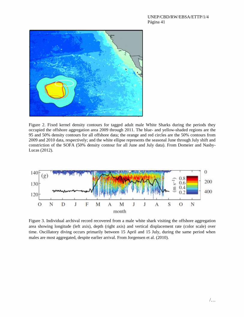
UNEP/CBD/RW/EBSA/ETTP/1/4
Página 41
/…
Figure 2. Fixed kernel density contours for tagged adult male White Sharks during the periods they
occupied the offshore aggregation area 2009 through 2011. The blue- and yellow-shaded regions are the
95 and 50% density contours for all offshore data; the orange and red circles are the 50% contours from
2009 and 2010 data, respectively; and the white ellipse represents the seasonal June through July shift and
constriction of the SOFA (50% density contour for all June and July data). From Domeier and Nasby-
Lucas (2012).
Figure 3. Individual archival record recovered from a male white shark visiting the offshore aggregation
area showing longitude (left axis), depth (right axis) and vertical displacement rate (color scale) over
time. Oscillatory diving occurs primarily between 15 April and 15 July, during the same period when
males are most aggregated, despite earlier arrival. From Jorgensen et al. (2010).

UNEP/CBD/RW/EBSA/ETTP/1/4
Página 42
/…
Figure 4. The White Shark Offshore Aggregation Area (from Domeier and Nasby-Lucas, 2012) overlaid
on shipping traffic data layer (from Halpern et al., 2008)
Figure 5. The White Shark Offshore Aggregation Area (from Domeier and Nasby-Lucas, 2012) overlaid
on cumulative impacts (including climate change) data layer (from Halpern et al., 2008).

UNEP/CBD/RW/EBSA/ETTP/1/4
Página 43
/…
Rights and permissions
CRC Press, Boca Raton, FL, publisher of Figure 1 above from Domeier and Nasby-Lucas (2012) may
require permission to share or publish.

UNEP/CBD/RW/EBSA/ETTP/1/4
Página 44
/…
ÁREA NO. 2: ATOLÓN DE CLIPPERTON
(CLIPPERTON ATOLL)
Abstract Clipperton is the only atoll in the Tropical Eastern Pacific and, for this reason; it represents a particular
and unique ecosystem for this area. Located more than 1000 km off the Mexican coast, it constitutes both
an outpost for the migratory flux coming from the west and a kind of isolate for many marine species with
low larval dispersion range. Endemism is present in several major taxa, like fish (5%), or crustaceans
(6%). The atoll does seem to be used as a reproduction ground by sharks, at least for the white tip shark
(Carcharhinus albimarginatus), a species classified as Near Threatened by the IUCN. Masked Booby
(Sula dactylatra) occurs in globally significant numbers, and the site qualifies as an Important Bird Areas
(IBAs) under BirdLife criteria. Around 110,000 individuals are estimated to be present here, with 20,000
pairs breeding, making it the largest colony in the world of this species. This area limit is defined by the
foraging range of this species.
Introduction
The Clipperton Island is a 3-4 km wide atoll with a complete land ring, 40-360 m wide and 1.7 km2in area
(Jost, 2003). Except for an isolated volcanic rock 29 m above sea level, the highest elevation is 4 m. The
atoll encloses alagoon with poor circulation and no connection to the open sea, which hence constitutes a
particular anoxic aquatic environment in the area (Charpy et al., 2009). Located in a zone of deep waters;
Clipperton is part of a narrow ridge of sea mounts. Deep waters are therefore very close offshore from
Clipperton, and there is no peri-insular shelf. The depth of 200 m is reached between 300 and 700 m from
the seashore.
Location
Clipperton Island (10° 17’ N, 109° 12’ W) is a French Overseas territory, located between the tip of Baja
California and the Equator. The closest other land masses are the Revillagigedo Islands, 950 km to the
north, and Manzanillo on the coast of Colima, Mexico, 1000 km to the northeast.
Limits of the area are based on the area of foraging of the boobie Sula dactylatra, which is within 200 km
of the island (Weimerskirch et al., 2008). The area also includes a set of sea mounts on which few
information is available but that would deserve to be investigated. The area lies entirely within the
Clipperton EEZ.
Feature description of the proposed area
The Clipperton Island is an isolated atoll with a rather low biodiversity. Its marine fauna contains taxa
both from western and eastern Pacific, and Clipperton constitutes a stepping stone between these two
biogeographic regions in a west to east direction and trend (Lessios & Robertson, 2006).
The biodiversity of the island has been studied through several oceanographic missions from USA,
Mexico, and France. During the last interdisciplinary exploration conducted in 2005 a complete study was
completed and published (Charpy, 2009).
Among other taxa, 21 species of corals (Porites spp.,Pocillopora spp., Pavona minuta et P. varians) are
reported(Flot & Adjeroud, 2009); 277 species of molluscs (Kayser, 2009); 95 species of crustaceans (6%
of endemism) with one terrestrial species Gecarcinus planatus (Poupin et al., 2009); 28 species of
echinoderms (Solís-Marín & Laguarda-Figueras, 2009);163 species of fish (Béarez & Séret, 2009). Seven
species of these fishes are endemic to Clipperton and six species of sharks, including wale and tiger
sharks, and two manta rays are known to inhabit the island surroundings (Béarez & Séret, 2009). The atoll
does seem to be used as a reproduction ground, at least for the white tip shark, Carcharhinus
albimarginatus.

UNEP/CBD/RW/EBSA/ETTP/1/4
Página 45
/…
The coral reef cover is healthy and extends all around the atoll. The specific diversity is high compared to
other TEP oceanic islands, which is not the case for other groups like molluscs, crustaceans, echinoderms
or fish. But endemism in the island is an important feature, being around 5% in fish and 6% in
crustaceans.
Marine reptiles are rare, sea turtle nesting have not been observed but stranding have been recorded,
especially of Lepidochelys olivacea (Lorvelec et al., 2009). One species of sea snake has also been
observed, Pelamis platura (Ineich et al., 2009).
Sea bird breeding populations presently include the masked booby’s largest breeding colony (20 000
pairs) and the brown booby’s second largest one in the world (Pitman et al. 2005, Weimerskirch et al.,
2008). Eleven species of seabird are known to breed on the island and feed in the surrounding waters,
making it one of the most diverse tropical seabird colonies in the region. Twenty four species of visiting
birds have been observed (Weimerskirch et al., 2008).
Masked Booby (Sula dactylatra) occurs in globally significant numbers, and the site qualifies as an
Important Bird Areas (IBAs) under BirdLife criteria. 110,000 individuals are estimated to be present on
the island. The site also holds 10-20,000 breeding individuals of Brown Booby (Sula leucogaster) as well
as smaller numbers of Great Frigatebird (Fregata minor), red-footed boobies (Sula sula), wedge-tailed
shearwater (Puffinus pacificus) and four species of terns. All these species are regarded as Least Concern
on the IUCN Red List.
Based on literature review the foraging areas of the sulid species are likely to be found within 200 km of
the island during the breeding season. We used the feeding area extent to define the area boundary (see
http://seabird.wikispaces.com/Masked+Booby for details of foraging behaviour and distances).
Masked Booby feeds on large species of shoaling fish, especially flying fish, but will also take large
squid. Au and Pitman (1986) and Balance et al. (1997) found that in the eastern tropical Pacific, nearly a
quarter (24%) of all foraging flocks dominated by Red-footed and Masked Boobies were found in
association with marine mammals and tunas.
Feature condition and future outlook of the proposed area
Clipperton Island is currently uninhabited but remains of temporary encampments testify that it is used
for short visits, probably by crews of fishing boats and few tourists. Major threats that may reduce at
short-term the high biological interest of this island include black rats introduced in the past, and
fishermen, who regularly land to collect lobsters and coconuts, and may introduce other invasive species.
The impact of the tuna fisheries, mainly targeting on yellowfin tuna, is high inside the foraging area of
boobies around Clipperton, with a catch of close to 21,600 tons (IATTC 2007).
Reef fish collecting is also a danger as the endemic and Near Threatened Clipperton angelfish
(Holacanthus limbaughi), is highly prized in the aquarium trade
(http://www.iucnredlist.org/details/165836/0).
Satellite tracking studies have been undertaken on the masked booby, though not on the other species
present on the island. Tracking of the other species would help to define their key foraging areas more
completely.
Also, the trends of the shark populations around the atoll need to be investigated in relation with inter-
oceanic migrations between TEP islands. A connection between Galapagos and Clipperton have been
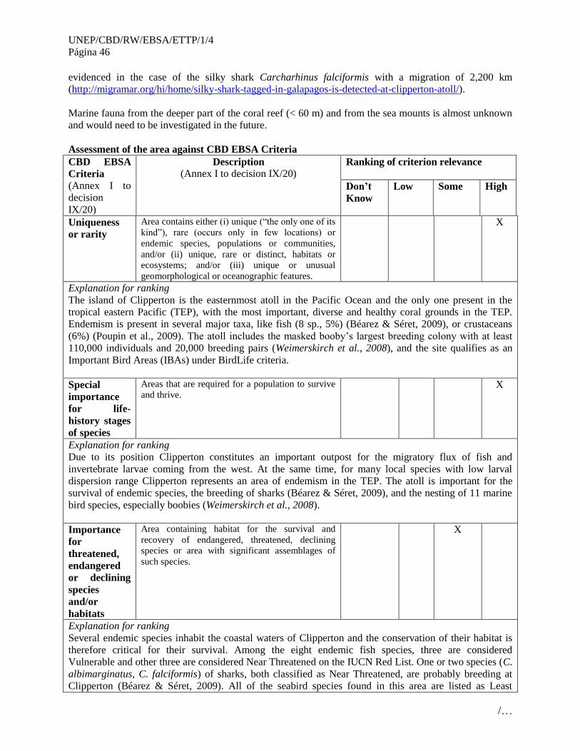
UNEP/CBD/RW/EBSA/ETTP/1/4
Página 46
/…
evidenced in the case of the silky shark Carcharhinus falciformis with a migration of 2,200 km
(http://migramar.org/hi/home/silky-shark-tagged-in-galapagos-is-detected-at-clipperton-atoll/).
Marine fauna from the deeper part of the coral reef (< 60 m) and from the sea mounts is almost unknown
and would need to be investigated in the future.
Assessment of the area against CBD EBSA Criteria
CBD EBSA
Criteria
(Annex I to
decision
IX/20)
Description
(Annex I to decision IX/20) Ranking of criterion relevance
Don’t
Know
Low Some High
Uniqueness
or rarity
Area contains either (i) unique (“the only one of its
kind”), rare (occurs only in few locations) or
endemic species, populations or communities,
and/or (ii) unique, rare or distinct, habitats or
ecosystems; and/or (iii) unique or unusual
geomorphological or oceanographic features.
X
Explanation for ranking
The island of Clipperton is the easternmost atoll in the Pacific Ocean and the only one present in the
tropical eastern Pacific (TEP), with the most important, diverse and healthy coral grounds in the TEP.
Endemism is present in several major taxa, like fish (8 sp., 5%) (Béarez & Séret, 2009), or crustaceans
(6%) (Poupin et al., 2009). The atoll includes the masked booby’s largest breeding colony with at least
110,000 individuals and 20,000 breeding pairs (Weimerskirch et al., 2008), and the site qualifies as an
Important Bird Areas (IBAs) under BirdLife criteria.
Special
importance
for life-
history stages
of species
Areas that are required for a population to survive
and thrive. X
Explanation for ranking
Due to its position Clipperton constitutes an important outpost for the migratory flux of fish and
invertebrate larvae coming from the west. At the same time, for many local species with low larval
dispersion range Clipperton represents an area of endemism in the TEP. The atoll is important for the
survival of endemic species, the breeding of sharks (Béarez & Séret, 2009), and the nesting of 11 marine
bird species, especially boobies (Weimerskirch et al., 2008).
Importance
for
threatened,
endangered
or declining
species
and/or
habitats
Area containing habitat for the survival and
recovery of endangered, threatened, declining
species or area with significant assemblages of
such species.
X
Explanation for ranking
Several endemic species inhabit the coastal waters of Clipperton and the conservation of their habitat is
therefore critical for their survival. Among the eight endemic fish species, three are considered
Vulnerable and other three are considered Near Threatened on the IUCN Red List. One or two species (C.
albimarginatus, C. falciformis) of sharks, both classified as Near Threatened, are probably breeding at
Clipperton (Béarez & Séret, 2009). All of the seabird species found in this area are listed as Least

UNEP/CBD/RW/EBSA/ETTP/1/4
Página 47
/…
Concern.
Vulnerability,
fragility,
sensitivity, or
slow recovery
Areas that contain a relatively high proportion of
sensitive habitats, biotopes or species that are
functionally fragile (highly susceptible to
degradation or depletion by human activity or by
natural events) or with slow recovery.
X
Explanation for ranking
The marine resources (tunas, sharks, lobsters) around the atoll and in the EEZ are heavily exploited.
These fisheries affect the target species but also the boobies which rely heavily on tunas concentrations
for feeding, Sharks and all seabirds are long lived and often taking several years to reach maturity,
making them vulnerable and slow to recover following declines.
Biological
productivity
Area containing species, populations or
communities with comparatively higher natural
biological productivity.
X
Explanation for ranking
Little information is available concerning the biological productivity in the area.
Weimerskirch et al (2008) found that at Clipperton Island, Masked Boobies foraged over deep waters that
had relatively high productivity (1.3 ± 0.4 gC m–2 d–1), but were not significantly different from other
zones not visited within the foraging range of the population. The foraging area was located in a zone of
high primary production that had drifted from the coasts of Central America. This large-scale feature
appears to be predictable and explains the strong seasonality in the breeding season of the population.
This peak of productivity occurs year after year around the island in January to March, i.e. during the time
of highest energy demand for the colony, when birds are feeding large chicks.
It was estimated that in January, the masked boobies of Clipperton were taking an estimated 63.2 (adults)
+ 6.0 (chicks) = 69.2 t of fishes daily, suggesting these relatively productive waters were supporting large
amounts of fish biomass.
Biological
diversity
Area contains comparatively higher diversity of
ecosystems, habitats, communities, or species, or
has higher genetic diversity.
X
Explanation for ranking
The marine biodiversity, even if low, consists in an original mixture of species among most of taxa
(molluscs, crustaceans, fishes), with the presence in almost equal quantities of species originating from
the west and eastern Pacific regions.
Eleven species of seabird are known to breed on the island and feed in the surrounding waters, making it
one of the most diverse tropical seabird colonies in the region. Given the propensity of the Sulid species
to form foraging flocks over schools of cetaceans and subsurface predators (particularly Yellowfin Tuna
and dolphins in this area), the abundance of these species is therefore thought to be high as they are able
to support such large colonies of Sulids.
Naturalness Area with a comparatively higher degree of
naturalness as a result of the lack of or low level of
human-induced disturbance or degradation.
X
Explanation for ranking
Surprisingly for such an isolated island, Clipperton is often visited, mostly by crews of fishing boats who
land for coconut and lobster collecting. The open waters around are heavily fished for tuna and shark.
Hence the atoll and its surroundings are submitted to seasonal disturbance during the fishing season
(January to march).
Sharing experiences and information applying other criteria
UNEP/CBD/RW/EBSA/ETTP/1/4
Página 48
/…
Other
Criteria
Description
Ranking of criterion relevance
Don’t
Know
Low Medium High
Add relevant
criteria
BirdLife International Important Bird Area
(IBA) criteria
X
Explanation for ranking
BirdLife IBA criteria A4ii is triggered here, an area holding >1% of the global population of a seabird
species, on the basis of the Masked Booby congregation. IBA criteria A4iii is also triggered, an area
holding >20,000 pairs of seabirds.
Add relevant
criteria
The UICN Red List of Threatened Species X
Explanation for ranking
Three endemic fish species of Clipperton are considered Near Threatened: Holacanthus limbaughi,
Stegastes baldwini, Pseudogramma axelrodi Three are considered vulnerable: Myripristis gildi,
Bathygobius lineatus arundelii, Thalassoma robertsoni, Xyrichtys wellingtoni.
References
Allen G. R., 1995. Thalassoma robertsoni, a new species of wrasse (Labridae) from
Clipperton Island in the tropical eastern Pacific. Rev. fr. Aquariol. 22: 75-79.
Allen G. R., 1995. Clipperton: the forgotten island. Trop. Fish Hobb. 44[1(475)]: 46-71.
Allen G. R. & Robertson D. R., 1992. Serranus socorroensis, a new species of serranid
fish from the tropical eastern Pacific. Rev. fr. Aquariol. 19 : 37-40.
Allen G. R. & Robertson D. R., 1992. Two new species of wrasse (Labridae:
Halichoeres) from the tropical eastern Pacific. Rev. fr. Aquariol. 19 : 47-52.
Allen G. R. & Robertson D. R., 1995. Pseudogramma axelrodi, a new species of serranid
fish from the tropical eastern Pacific Ocean. Trop. Fish Hob. 44[1(475)] : 72-75.
Allen G. R. & Robertson D. R., 1995. Xyrichtys wellingtoni, a new species of wrasse
(Labridae) from Clipperton Island, tropical eastern Pacific Ocean. Rev. fr. Aquariol. 22 :
80-82.
Allen G. R. & Robertson D. R., 1997. An annotated checklist of the fishes of Clipperton
Atoll, tropical eastern Pacific. Rev. Biol. Trop. 45(2) : 813-843.
Allen G. R. & Robertson D. R., 1999. Epinephelus clippertonensis, a new species of
serranid fish from the tropical eastern Pacific. Rev. Fr. Aquariol. 26(1-2) : 11-15.
Au D. W. K. & Pitman R. L., 1986. Seabird interactions with dolphins and tuna in the
eastern tropical Pacific. Condor 88: 304-317.
Baldwin W. J., 1963. A new chaetodont fish, Holacanthus limbaughi, from the Eastern
Pacific. Los Angeles County Museum Contrib. Sci. 74 : 1-8.
Ballance L. T., Pitman R. L.& Reilly S. B., 1997. Seabird community structure along a
productivity gradient: Importance of competition and energetic constraint. Ecology 78:
1502-1518.

UNEP/CBD/RW/EBSA/ETTP/1/4
Página 49
/…
Béarez P. & Séret B., 2009. Les poissons. In L. Charpy (coord.), Clipperton,
environnement et biodiversité d'un microcosme océanique – pp. 145-156. Patrimoines
naturels 68. Paris: MNHN/IRD.
BirdLife International (2011). Foraging range and behaviour factsheet of Masked Booby
http://seabird.wikispaces.com/Masked+Booby
BirdLife International (2012) Important Bird Areas factsheet: Clipperton Island
Downloaded from www.birdlife.org/datazone/site/search on 29/08/2012
Charpy L. (coord.), 2009. Clipperton, environnement et biodiversité d'un microcosme
océanique. Patrimoines naturels 68. Paris: MNHN/IRD.
Charpy L., Rodier M. & Sarazin G., 2009. Biogéochimie du lagon. In L. Charpy (coord.),
Clipperton, environnement et biodiversité d'un microcosme océanique – pp. 67-80.
Patrimoines naturels 68. Paris: MNHN/IRD.
Ehrhardt J. P. & Plessis Y., 1972. Aperçu de la faune ichtyologique de Clipperton. Actes
du 97ème Congrès national des sociétés savantes, Nantes, mars 1972, section Sciences, t.
III - pp.757-769.
Flot J. F. & Adjeroud M., 2009. Les coraux. In L. Charpy (coord.), Clipperton,
environnement et biodiversité d'un microcosme océanique – pp. 155-162. Patrimoines
naturels 68. Paris: MNHN/IRD.
Garman S., 1899. Concerning a species of lizard from Clipperton Island. Proc. New
England Zool. Club 1 - pp. 59-62.
Garman S., 1899. A species of goby from the shores of Clipperton Island. Proc. New
England Zool. Club 1 - pp. 63-64.
Glynn P. W. & Ault J. S., 2000. A biogeographic analysis and review of the far eastern
Pacific coral reef region. Coral Reefs 19(1) - pp. 1-23.
Glynn P. W., VERON J. E. N. & WELLINGTON G. M., 1996. Clipperton Atoll (eastern
Pacific): oceanography, geomorphology, reef-building coral ecology and biogeography.
Coral Reefs 15 - pp. 71-99.
Heller E. & Snodgrass R. E., 1903. Papers from the Hopkins Stanford Galapagos
expedition 1898-1899. XV. New fishes. Proc. Wash. Acad. Sci. 5 - pp. 189-229.
IATTC, 2007. Annual Report of the Inter- American Tropical Tuna Commission 2005.
IATTC La Jolla, California, 152 p.
Ineich I., Berot S. & Garrouste R., 2009. Les reptiles terrestres ou comment survivre en
devenant "vampires". In L. Charpy (coord.), Clipperton, environnement et biodiversité
d'un microcosme océanique – pp. 347-380. Patrimoines naturels 68. Paris: MNHN/IRD.
Jost, C.H. 2003. Clipperton. Île de La Passion : une aire française du Pacifique à protéger ! In J.-
M. Lebigue & P.-M. Decoudras (Eds). Les aires protégées insulaires et littorales tropicales.
Proceedings of the « Dymset, Transcultures, Sepanrit » Symposium. Nouméa, New Caledonia,
October 2001. CRET (Institut de Géographie Louis Papy), Collection Îles et Archipels 32,
Pessac, France. pp. 223-244.

UNEP/CBD/RW/EBSA/ETTP/1/4
Página 50
/…
Kayser K. L., 2009. Les mollusques. In L. Charpy (coord.), Clipperton, environnement et
biodiversité d'un microcosme océanique – pp. 217-234. Patrimoines naturels 68. Paris:
MNHN/IRD.
Lafaix J. M. & Niaussat P., 1969. Étude toxicologique des poissons et des animaux
marins du récif et du lagon de l'atoll de Clipperton. Rapport particulier 47, CRSSA/BIO-
ECO, Paris.
Lessios H. A. & Robertson D. R., 2006. Crossing the impassable: genetic connections in
20 reef fishes across the eastern Pacific barrier. Proc. R. Soc. B 3543 : 1-8.
Limbaugh C., 1963. Field notes on sharks. In P. W. Gilbert (ed.), Sharks and survival.
D.C. Heath and Co. Boston - pp. 63-94.
Lorvelec O., Pascal M. & Fretey J., 2009.Sea turtles on Clipperton Island (Eastern Tropical
Pacific) Sea turtles on Clipperton Island (Eastern Tropical Pacific). Marine Turtle Newsletter
124: 10-13.
Pitman, R.L., L.T. Ballance & C. Bost. 2005. Clipperton Island: pig sty, rat hole and
booby prize. Marine Ornithology 33: 193-194.
Poupin J., Bouchard J.-M., Albenga L., Cleva R., Hermoso-Salazar M., Solís-Weiss V.,
2009. Les crustacés décapodes et stomatopodes, inventaire, écologie et zoogéographie. In
L. Charpy (coord.), Clipperton, environnement et biodiversité d'un microcosme
océanique – pp. 163-216. Patrimoines naturels 68. Paris: MNHN/IRD.
Robertson D. R., 1996. Holacanthus limbaughi, and Stegastes baldwini, endemic fishes
of Clipperton island, tropical eastern Pacific. Coral Reefs 15: 132.
Robertson D. R. & Allen G. R., 1996. Zoogeography of the shorefish fauna of Clipperton
Atoll. Coral Reefs 15 : 121-131.
Sachet M.-H., 1960. Histoire de l’île Clipperton. Cahiers du Pacifique 2: 3-32.
Sachet M.-H., 1962. Monographie physique et biologique de l'île de Clipperton. Annales
de l'Institut océanograhique 40(1) - 107 p.
Schmitt W. L. & Schultz L. P., 1940. List of the fishes taken on the Presidential Cruise of
1938. Smithsonian Miscellaneous Collections 98(25) – pp. 1-10.
Solís-Marín F. A. & Laguarda-Tabueras A., 2009. Les échinodermes. In L. Charpy
(coord.), Clipperton, environnement et biodiversité d'un microcosme océanique – pp.
235-248. Patrimoines naturels 68. Paris: MNHN/IRD.
Snodgrass R. E. & Heller E., 1905. Papers from the Hopkins-Stanford Galapagos
Expedition, 1898-99. XVII. Shore fishes of the Revillagigedo, Clipperton, Cocos and
Galapagos Islands. Proc. Wash. Acad. Sci. 6: 333-427.
Weimerskirch H., Le Corre M., Bost C. A., 2008. Foraging strategy of masked boobies
from the largest colony in the world: relationship to environmental conditions and
fisheries. Mar Ecol Prog Ser 362: 291–302.
Wellington G. M., Glynn P. W. & Veron J. E. N., 1995. Clipperton island: a unique atoll
in the eastern Pacifique. Coral Reefs 14(3) – pp. 162.

UNEP/CBD/RW/EBSA/ETTP/1/4
Página 51
/…
Maps and Figures
Foraging zones of Sula dactylatra around Clipperton. Concentric circles centred on Clipperton
indicate 100 and 200 km distances (Weimerskirch et al., 2008)

UNEP/CBD/RW/EBSA/ETTP/1/4
Página 52
/…
UNEP/CBD/RW/EBSA/ETTP/1/4
Página 53
/…
ÁREA NO. 3: SANTUARIO VENTILAS HIDROTERMALES DE LA
CUENCA DE GUAYMAS
(GUAYMAS BASIN HYDROTHERMAL VENTS SANCTUARY)
Abstract
Deep-sea hydrothermal vents are a major source of dissolved compounds for the world’s oceans.
Guaymas Basin in the Gulf of California (Fig. 1) is a hydrothermally impacted, semienclosed basin where
oxidation and precipitation of oxides are particularly intense. It is an unusual hydrothermal system due to
its close proximity to the coast, where high sedimentation rates maintain a thick blanket of organic
compound-rich sediment over the ridge axis. Hydrothermal solutions ascend through and react with this
overlying sediment, resulting in fluids that emerge from the seafloor. In the Gulf of California these
hydrothermal vents represent the epitome of an isolated community because they have an in situ food
resources not directly linked to photoautotrophic production, have a unique benthic species composition
and the distances between vent fields span a few hundreds of kilometers. Protists are highly specialized
and diverse and its biomass in hydrothermal plumes represent a source of organic carbon and energy for
pelagic organisms. Larval and postlarval forms of benthic organisms associated to hydrothermal activity
disperse in the water column. A recent interest in oil and gas, energy, mineral, deepsea fishery and
biosprospecting resources required to propose the Guaymas Basin Hydrothermal Vents Sanctuary as an
area meeting EBSA criteria, seeking to protect a unique habitat in the Gulf of California before
exploration and testing occurs.
Introduction
The Gulf of California is a subtropical marginal sea with exceptionally high rates of primary productivity.
The annual biogenic sediment fluxes are largely dominated by silica, with diatoms as the major
contributor to the opal flux. The Guaymas Basin is an actively spreading oceanic basin, part of the system
of spreading axes and transform faults extending from the East Pacific Rise to the San Andreas Fault
System: It is therefore tectonically very active and consists of two rift valleys separated by a 20-km
transform fault. Hydrothermal fluids are discharged both through chimneys at 270 to 325°C and through
the porous sediment. The basin is characterized by a high sedimentation rate, which keeps its floor and
rifts covered with hemipelagic sediment which accumulates at a rate of about 1-1.2 m per 1000 y. The
southern rift sediments are all late Quaternary diatomaceous ooze and turbidites intruded by various sills.
Extensive hydrothermal alteration and high in situ heat flow occurs. Biogenic gas occurs at all sites;
thermogenic hydrocarbons, ranging to C7 and derived from the endogenous organic matter have been
described.
The Guaymas Basin is unique compared to other thermal vent sites in that the organic matter in the
rapidly accumulating hemipelagic sediment near the vent is subject to the thermal stress at intruded sills
and is readily pyrolyzed to petroleum like products, diffuse venting through sediments at temperatures up
to 200oC with differences related to interactive physical, chemical and microbiological processes as well
as the influence of multiple sources for the petroleum. This composition indicates an origin by thermal
alteration and rapid quenching by hydrothermal removal followed by condensation at the seabed. At
mound surface or in unconsolidated sediments petroleum is presumably accessible to microbial
degradation being a carbon source equivalent in magnitude to that of CO2 fixation (chemosynthesis).
Some of the thermally produced hydrocarbons at Guaymas Basin are significant carbon sources to vent
microbiota .and a major carbon source for vent biota.
Hydrothermal sediments of the Guaymas Basin contain highly diverse anaerobic thermophilic
microorganisms, including methanogens, sulfate-reducing bacteria, and presumably also methanotrophs.

UNEP/CBD/RW/EBSA/ETTP/1/4
Página 54
/…
Phylogenetically diverse thermophilic sulfate-reducers have been isolated from deep-sea hydrothermal
vents at Guaymas Basin. In some localities near the sediment surface, abundant methanotrophic archaeal
communities reoxidize methane and incorporate it into their cellular biomass. With methanogenic as well
as methane-oxidizing communities, the Guaymas Basin sediments provide a model system for studying
anaerobic methane cycling, with applicability to diverse hydrothermal and nonhydrothermal marine
sediments and subsurface environments. In addition to petroleum hydrocarbons, the chemical milieu of
the Guaymas vents includes short-chain organic acids and ammonia. The sulfate-reducing bacteria (SRB)
are a large and extremely diverse physiological group of anaerobic microorganisms capable of degrading
a wide range of organic substrates. This eukaryotic diversity in the hydrothermal vent environments of
Guaymas Basin is associated to the anoxic sediments and the overlaying seawater and is explained by at
least two mechanisms. On the one hand bacterial populations in these sediments are primarily
characteristic of anoxic, reduced, hydrocarbon-rich sedimentary habitats. On the other, the adaptation to
anoxic environments is evidenced by specific affinity of environmental sequences to aerotolerant
anaerobic species superimposed against a background of widely distributed aerophilic and aerotolerant
protists, some of which may migrate into and survive in the sediment. Others (e.g., phototrophs) are
simply deposited by sedimentary processes. In addition metazoans with diverse symbiotic interactions,
many unknown within the meio- and macrofaunal communities in the soft sediments and bacterial mats.
The Guaymas Basin belongs to the MPA system “Ventilas Hidrotermales de la Cuenca de Guaymas y de
la dorsal del Pacífico oriental” (Hydrothermal vents of the Guaymas Basin and the Eastern Pacific Rise)
declared and published in the Official Diary on June 5 2009. It accounts for an extension of 145,565 ha
that includes the polygons both in the Gulf of California and the Eastern North Pacific, respectively. The
Guaymas Basin belongs to the Gulf of California marine ecoregion, the total MPA system expands in
addition within the Southcalifornian Pacific and the Mexican Transitional Pacific ecoregions, within the
Mexican EEZ.
Major oil and gas and mining industries in Mexico have expressed their interest for the exploration of
energy sources in the past 5 years with the strong possibility of commercial exploration commencing in
10 years or less. The mining activity could remove all sulphides form active venting areas affecting the
uniqueness of this ecosystem.
Location
The polygon occurs within the Gulf of California within the Mexican Exclusive Economic Zone
jurisdiction. Fig. 1. The coordinates:
Latitude N max 27°05’49.54” - Latitude N min 26°57’20.43”
Longitude W max 111°27’53.01” - Longitude W min 111°19’24.88”
At depths below 500 metres in the water column and on the seafloor.
Feature description of the proposed area
The Guaymas Basin is an actively spreading oceanic basin, part of the system of spreading axes and
transforms faults extending from the East Pacific Rise to the San Andreas Fault System: It is therefore
tectonically very active and consists of two rift valleys separated by a 20-km transform fault. The basin is
characterized by a high sedimentation rate, which keeps its floor and rifts covered during the formation of
complex ocean crust and intrusions.
Abyssal sediments (2500 m deep) affected by hydrothermal activity and surrounding the hydrothermal
vents. Obligate nodule fauna that require chemosynthetic processes for survival. Meio- and macro-
benthos are endemic to these chemosynthetic ecosystems. Megafauna associated with hydrothermal vent

UNEP/CBD/RW/EBSA/ETTP/1/4
Página 55
/…
activity is supported by symbiotic bacteria. Microbial communities with geochemical roles cover the soft
sediments and active vent structures.
Feature condition and future outlook of the proposed area
This is a unique area by its protest diversity, the diverse biological processes undergoing in the sediment
water interface. At present the area is relatively pristine affected solely by the local impacts of scientific
research but may in a period of 10 years be subject to oil and gas exploration, test mining and potentially
deep sea fishery leading to a rapid decline of its current conditions.
Assessment of the area against CBD EBSA Criteria
CBD EBSA
Criteria
(Annex I to
decision
IX/20)
Description
(Annex I to decision IX/20) Ranking of criterion relevance
Don’t
Know
Low Some High
Uniqueness
or rarity
Area contains either (i) unique (“the only one
of its kind”), rare (occurs only in few
locations) or endemic species, populations or
communities, and/or (ii) unique, rare or
distinct, habitats or ecosystems; and/or (iii)
unique or unusual geomorphological or
oceanographic features.
X
Explanation for ranking
The Guaymas Basin is unique compared to other thermal vent sites. Most hydrothermal vents are located
at distance from the continental mass; the Guaymas Basin due to its geographic location receives organic
matter from hemipelagic origin that is rapidly accumulating as sediments near the vent (see references on
organic flux to deep). This sediment is subject to the thermal stress at intruded sills and is readily
pyrolyzed to petroleum like products (see references on the geochemistry). Both heated water at
temperatures up to 200oC and diffuse venting through sediments of the pyrolyzed petroleum like products
affect the seafloor. These generate gradients in physical, chemical conditions that are used by
microorganisms (see references on geochemistry and endemisms) that support diverse microbiological
processes and promote a highly diverse protist assemblage (see references on processes and endemisms).
Special
importance
for life-
history stages
of species
Areas that are required for a population to
survive and thrive. X
Explanation for ranking
Hydrothermal vents are an important habitat for metazoans (see references on Diversity). Connectivity
among hydrothermal vents has been described within the Guaymas Basin; both in the northern Trogh and
the Southern Trough (see references on Connectivity). The complex architectonical 3S structure of the
habitat, characterized by diverse types and sizes of chimneys provides refuge and food supply to adult
background abyssal fish, invertebrates and is habitat and provides food supply to larval stages of
abyssopelagic, mesopelagic invertebrate and vertebrate species through the high densities of free-living
bacteria (see references on Larval habitat and stages; Food sources). Some of these species have
economic relevance or are potentially important to deep sea fishery (see references on Polygon definition
MPA/hydrodynamics).
Little has been described of the relevance of the hydrothermal vents as a habitat for highly specialized
protist species. This is because the naturalness in which these microorganisms are found thriving on
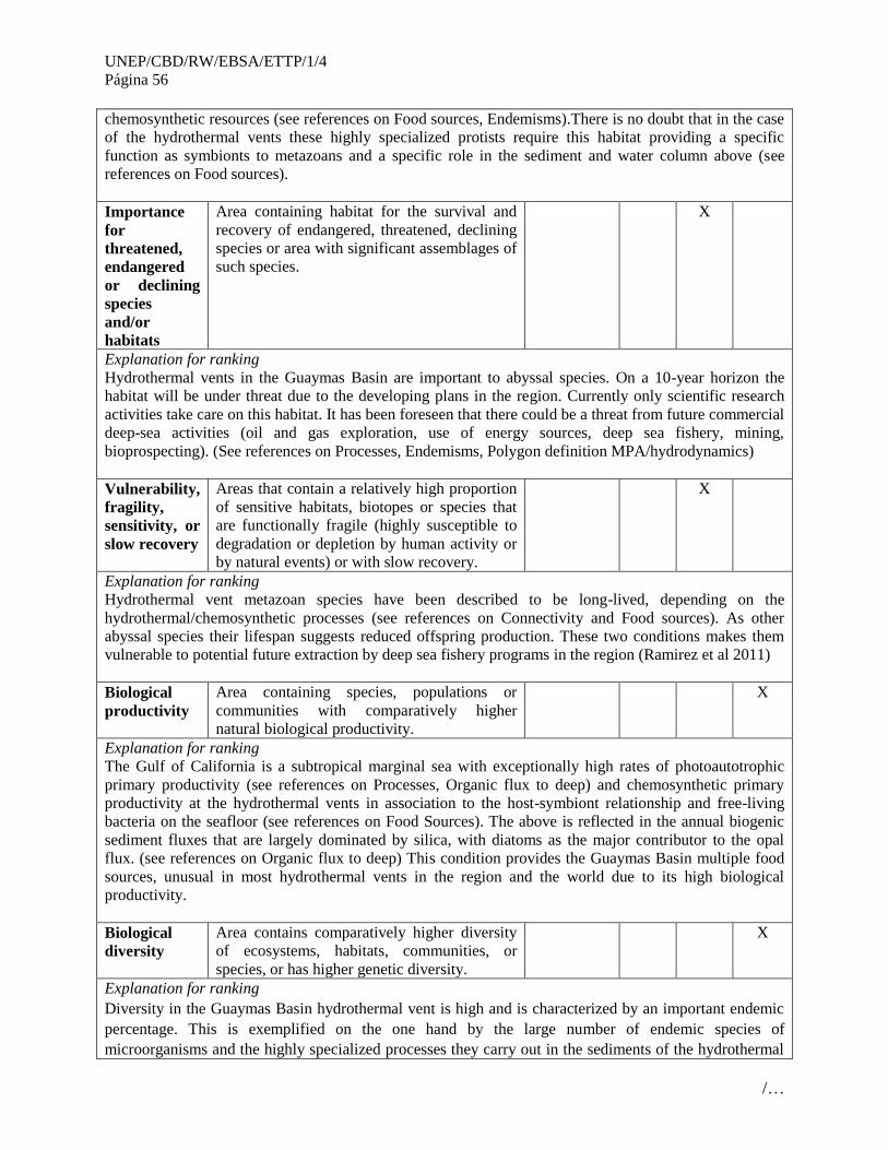
UNEP/CBD/RW/EBSA/ETTP/1/4
Página 56
/…
chemosynthetic resources (see references on Food sources, Endemisms).There is no doubt that in the case
of the hydrothermal vents these highly specialized protists require this habitat providing a specific
function as symbionts to metazoans and a specific role in the sediment and water column above (see
references on Food sources).
Importance
for
threatened,
endangered
or declining
species
and/or
habitats
Area containing habitat for the survival and
recovery of endangered, threatened, declining
species or area with significant assemblages of
such species.
X
Explanation for ranking
Hydrothermal vents in the Guaymas Basin are important to abyssal species. On a 10-year horizon the
habitat will be under threat due to the developing plans in the region. Currently only scientific research
activities take care on this habitat. It has been foreseen that there could be a threat from future commercial
deep-sea activities (oil and gas exploration, use of energy sources, deep sea fishery, mining,
bioprospecting). (See references on Processes, Endemisms, Polygon definition MPA/hydrodynamics)
Vulnerability,
fragility,
sensitivity, or
slow recovery
Areas that contain a relatively high proportion
of sensitive habitats, biotopes or species that
are functionally fragile (highly susceptible to
degradation or depletion by human activity or
by natural events) or with slow recovery.
X
Explanation for ranking
Hydrothermal vent metazoan species have been described to be long-lived, depending on the
hydrothermal/chemosynthetic processes (see references on Connectivity and Food sources). As other
abyssal species their lifespan suggests reduced offspring production. These two conditions makes them
vulnerable to potential future extraction by deep sea fishery programs in the region (Ramirez et al 2011)
Biological
productivity
Area containing species, populations or
communities with comparatively higher
natural biological productivity.
X
Explanation for ranking
The Gulf of California is a subtropical marginal sea with exceptionally high rates of photoautotrophic
primary productivity (see references on Processes, Organic flux to deep) and chemosynthetic primary
productivity at the hydrothermal vents in association to the host-symbiont relationship and free-living
bacteria on the seafloor (see references on Food Sources). The above is reflected in the annual biogenic
sediment fluxes that are largely dominated by silica, with diatoms as the major contributor to the opal
flux. (see references on Organic flux to deep) This condition provides the Guaymas Basin multiple food
sources, unusual in most hydrothermal vents in the region and the world due to its high biological
productivity.
Biological
diversity
Area contains comparatively higher diversity
of ecosystems, habitats, communities, or
species, or has higher genetic diversity.
X
Explanation for ranking
Diversity in the Guaymas Basin hydrothermal vent is high and is characterized by an important endemic
percentage. This is exemplified on the one hand by the large number of endemic species of
microorganisms and the highly specialized processes they carry out in the sediments of the hydrothermal

UNEP/CBD/RW/EBSA/ETTP/1/4
Página 57
/…
vents (see papers on Endemicity). These bacterial populations characteristic of anoxic, reduced,
hydrocarbon-rich sedimentary habitats have been recently described (see references on Processes). In
addition background widely distributed aerophilic and aerotolerant protists were described in the early
microbiology papers. In addition the Guaymas basin is characterized by a highly diverse metazoan
composition (see references on Diversity and table species described for Guaymas Basin) many of which
are endemic and several thrive with diverse symbiotic interactions.
Additional diversity has been described for water column invertebrate and vertebrate faunal components
that are not specific to the hydrothermal vents but are of relevance as commercial resources and species of
devoted conservation efforts (see tables for birds, fish, marine mammals).
Naturalness Area with a comparatively higher degree of
naturalness as a result of the lack of or low
level of human-induced disturbance or
degradation.
X
Explanation for ranking
Almost pristine, affected solely at the local scale by activities of scientific research from the international
scientific community (see references on Polygon definition MPA), Guaymas Basin is a natural
chemosynthetic environment.
References
Geochemistry
Baczylinski, D.A., J.F. Farrington & H.W. Jannasch. 1988. Hydrocarbon in surface
sediments from the Guaymas Basin hydrothermal vent site. Organic Geochemistry
12(6):547-558.
Bernd R.T. Simoneit, O.E. Kawka And M. Brault Origin Of Gases And Condensates In
The Guaymas Basin Hydrothermal System (Gulf Of California) Chemical Geology, 71
(1988) 169-182 169
Carranza-Edwards, A. L. Rosales-Hoz & J.E. Aguayo-Camargo. 1990. Geochemical
study of hydrothermal core sediments and Rocks from the Guaymas Basin, Gulf of
California. Applied Geochemistry 5:71-42.
Dean W. E. 2006 The geochemical record of the last 17,000 years in the Guaymas Basin,
Gulf of California. Chemical Geology 232: 87–98
De la Lanza-Espino, G. y L. Soto. 1999. Sedimentary Geochemistry of HidrotermalVents
in Guaymas Basin, Gulf of California, Mexico. Applied Geochemistry. 14: 499-510.
Demina L. L. & S. V. Galkin. 2009. Geochemical Features of Heavy Metal
Bioaccumulation in the Guaymas Basin of the Gulf of California. Oceanology 49(5):
697–706.
Demina, L. L., S. V. Galkin & E. N. Shumilin. 2009. Bioaccumulation of some trace
elements in the biota of hydrothermal fields of the Guaymas Basin (Gulf of California).
Boletín de la Sociedad Geológica Mexicana 61(1):31-45.
Kastner, M. y R. Siever. 1983. Siliceous sediments of the Guaymas Basin: the effect
ofhigh temperature gradients on diagenesis. Journal of Geology 91, 629-641.

UNEP/CBD/RW/EBSA/ETTP/1/4
Página 58
/…
Larson, R.L., H.W. Menard y S. M. Smith. 1968. Gulf of California: a result of
oceanfloor spreading and transform faulting. Science 161(3843):781-784.
Lonsdale P. & K. Becker. 1985. Hydrothermal plumes, hot springs, and conductive heat
flow in the Southern Trough of Guaymas Basin Earth and Planetary Science Letters, 73
211-225.
Peter, J. M., B. R. T. Simoneit, O. E. Kawka y S. D. Scott. 1990. Liquid hydrocarbon
bearing inclusions in modern hydrothermal chimneys and mounds from the
southerntrough of Guaymas Basin, Gulf of California. In Organic Matter in
HydrothermalSystems--Petroleum Generation, Migration and Biogeochemistry (Ed. B. R.
T.Simoneit). Applied Geochemistry 5:51-63.
Peter, J. M., P. Peltonen, S. D. Scott, B. R. T. Simoneit y O. E. Kawka. 1991. n4Cages of
hydrothermal petroleum and carbonate in Guaymas Basin, Gulf of
California:implications for oil generation, expulsion and migration. Geology 19:253-256.
Ruelas-Inzunza, J., L.A. Soto & F. Páez-Osuna. 2003. Heavy-Metal Accumulation inthe
Hydrotermal Vent Clam Vesicomya gigas from Guaymas Basin, Gulf of California.Deep-
Sea Research 1(50):757-761.
Shmelev, I. P., A. A. Kuznetsov & S. V. Galkin. 2009. Heavy Metals in the Benthic
Animals from Hydrothermal Vents: Results of Neutron Activation Analysis. Oceanology,
49( 3): 429–431
Simoneit, B.R.T. & R.P. Philip. 1982. Organic Geochemistry of lipids and Kerogen and
the effects of Basalt Intrusions on unconsolidated ocean sediments: sites 477, 478 and
481, Guaymas Basin, Gulf of California. Initial Reports of the Deep Sea Drilling project
64:883-904
Simoneit, B.R.T., R.N. Leif, A.A. Sturtz, A.E. Styrdivant y A.E. Gieskes.
1992.Geochemistry of Shallow Sediments in Guaymas Basin, Gulf of California:
Hydrothermal Gas and Oil Migration and Effects of Mineralogy. Organical Geochemistry
18(6):765-784.
Stout, P. M. y A. C. Campbell. 1983. Hydrothermal alteration of near surfacesediments,
Guaymas Basin, Gulf of California. In: Cenozoic Marine Sedimentation,Pacific Margin,
U.S.A. (Ed. D. K. Larue & R. J. Steel), pp. 223-231. SEPMPacific Section.
Von Damm, K.L. J.M. Edmond, C.J. Measures y B. Grant. 1985. Chemistry ofSubmarine
Hydrothermal Solutions at Guaymas, Basin, Gulf of California. Geochimicaand
Cosmochimica Acta. 49:2221-2237.
Welhan J. A. & J. E. Lupton. 1987.Light Hydrocarbon Gases in Guaymas Basin
Hydrothermal Fluids: Thermogenic Versus Abiogenic Origin. AAPG Search and
Discovery Article #91037©1987 AAPG Southwest Section, Dallas, Texas, March 22-24,
Processes
Baczylinski, D.A., C.O. Wirsen & Holger Jannasch. 1989. Microbial utilization of
naturally occurring hydrocarbons at the Guaymas Basin hydrothermal vent site. Applied
and Environmental Microbiology 55(11):2832-2836.
UNEP/CBD/RW/EBSA/ETTP/1/4
Página 59
/…
Baker, E.T. y G.J. Massot. 1986. Hydrothermal plume measurements: a
regionalperspective. Science 234:980-982.
Kallmeyer, J. & A. Boetius. 2004. Effects of Temperature and Pressure on Sulfate
Reduction and Anaerobic Oxidation of Methane in Hydrothermal Sediments of Guaymas
Basin. Applied and Environmental Microbiology 70(2): 1231–1233.
Merewether R., M. S. Olsson & P. Lonsdale. 1985. Acoustically detected hydrocarbon
plumes rising from 2 km depths in Guaymas Basin, Gulf of California. Journal of
Geophysical Research, 90, 3075-3085.
Connectivity
Chevaldonne, P., D. Jollivet, A. Vangriesheim y D. Desbruyeres. 1997.
Hydrothermal-Vent Alvinellid Polychate Dispersal in the Eastern Pacific. 1. Influence of
Vent Site Distribution, Bottom Currents, and, Biological Patterns. Limmnology
andOceanography 42(1):67-80.
Tunnicliffe, V. & M.R. Fowler. 1996. Influence of sea-floor spreading on
globalhydrothermal vent fauna. Nature, 379: 531-533
Tunnicliffe, V., McArthur, AG, & D. McHugh. 1998. A biogeographical perspective
ofthe deep-sea hydrothermal vent fauna. Advances in Marine Biology. 34: 353-442.
Tyler, P.A. & C.M. Young. 2003 Dispersal at Hydrothermal Vents: A Summary ofRecent
Progress. Hydrobiologia 503:9-19.
Endemisms
Canganella, F. W. J. Jones A. Gambacorta & G. Antranikian. 1998. Thermococcus
guaymasensis Spm nov. and Thermococcus aggregans sp. nov., two novel thermophilic
archaea isolated from the Guaymas Basin hydrothermal vent site International Journal of
Systematic Bacteriology 48(1): 181-1 185.
Dhillon, A. A. Teske, J. Dillon, D. A. Stahl & M. L. Sogin. 2003. Molecular
Characterization of Sulfate-Reducing Bacteria in the Guaymas Basin Applied and
Environmental Microbiology, 69(5): 2765–2772.
Dick, G. J., Y. E. Lee & B. M. Tebo. 2006 Manganese (II)-Oxidizing Bacillus Spores in
Guaymas Basin Hydrothermal Sediments and Plumes. Applied And Environmental
Microbiology 72 (5): 3184–3190.
Edgcomb, V P., D. T. Kysela, A. Teske, A.de Vera Gomez & M. L. Sogin. 2002Benthic
eukaryotic diversity in the Guaymas Basin hydrothermal vent environment. PNAS 99
(11): 7658–7662.
Elsgaard, L., M. F. Isaksen, B. Barker, J. Rgensen, A.-Marie Alayse & H. W. Jannasch
1994. Microbial sulfate reduction in deep-sea sediments at the Guaymas
Basinhydrothermal vent area: Influence of temperature and substrates Geochimica et
Cosmochimica Acta 58(16): 3335-3343.
Götz D., A. Banta, T.J. Beverdige, A.I. Rushdi B.R.T. Simoneit y A.-L.
Reysenbach.2002. Persephonella marina gen. Nov, sp. Nov. and Persephonella

UNEP/CBD/RW/EBSA/ETTP/1/4
Página 60
/…
guaymasensis sp.Nov., Two Novel, Thermophilic, Hydrogen-oxidizing Microerophiles
from Deep-sea
Hydrothermal Vents. International Journal of Systematic and Evolutionary Microbiology
52: 1349-1359.
Jeanthon, C., Stephane, L. Haridon, V. Cueff, A Banta, A-L. Reysenbach & Daniel
Prieur. 2002. Thermodesulfobacterium hydrogeniphilum sp. nov., a thermophilic,
chemolithoautotrophic, sulfate-reducing bacterium isolated from a deep-sea hydrothermal
vent at Guaymas Basin, and emendation of the genus Thermodesulfobacterium.
International Journal of Systematic and Evolutionary Microbiology 52: 765–772.
McKay L. J., B. J. MacGregor, J. F. Biddle, D. B. Albert, H. P. Mendlovitz, D. R. Hoer,
J. S. Lipp, K. G. Lloyd & A. P. Teske. 2012. Spatial heterogeneity and underlying
geochemistry of phylogenetically diverse orange and white Beggiatoa mats in Guaymas
Basin hydrothermal sediments. Deep-Sea ResearchI 67: 21–31.
Nelson, D.C., C.D. Wirsen & Holger W. Jannash. 1989. Characterization of large,
autotrophic Beggiatoa spp. Abundant at Hydrothermal vents of the Guaymas Basin.
Applied and Environmental Microbiology 55(11): 2909-2917.
Teske, A., K.-U. Hinrichs, V. Edgcomb, A. de Vera Gomez, D. Kysela, S. P. Sylva, M.l
L. Sogin & H. W. Jannasch 2002 Microbial Diversity of Hydrothermal Sediments in the
Guaymas Basin: Evidence for Anaerobic Methanotrophic Communities Appl Environ
Microbiol. April; 68(4): 1994–2007.
Larval habitat & Stages
Cowen J. P., G. J. Massoth & E. T. Baker 1986. Bacterial scavenging of Mn and Fe in a
mid- to far-field hydrothermal particle plume. Nature, 322, 169-171.
Smith K.L. 1985. Macrozooplankton of a deep sea hydrothermal vent: In situ rates of
oxygen consumption. Limnology and Oceanography 30: 102-110.
Turner R. D., R. A. Lutz & D. Jablonski 1985. Modes of molluscan larval development at
deep-sea hydrothermal vents. In: The hydrothermal vents of eastern Pacific: An
overview, M. L. Jones, editor, Biological Society of Washington Bulletin, 6, 167-184.
Van Dover C. L., J. R. Factor, A. B. Williams & C. J. Berg. 1985. Reproductive patterns
of decapod crustaceans from hydrothermai vents. In: The hydrothermal vents of the
eastern Pacific: An overview, M. L. Jones, editor, Biological Society of Washington
Bulletin, 6, 223-227.
Wiebe, P. H., N. Copley, C.Van Dover, A. Tamse & F. Manrique.1988 Deep-water
zooplankton of the Guaymas Basin hydrothermal vent field. Deep-Sea Research, 35,(6):
985—1013.
Diversity
Desbruyeres, D., M. Segonzac & M. Bright. 2006. Handbook of Deep-Sea Hydrothermal
Vent Fauna 544 pages ISBN: 3854741545
UNEP/CBD/RW/EBSA/ETTP/1/4
Página 61
/…
Dhillon, A., M Lever, K. G. Lloyd, D. B. Albert, M. L. Sogin & Andreas Teske. 2005.
Methanogen Diversity Evidenced by Molecular Characterization of Methyl Coenzyme M
Reductase A (mcrA) Genes in Hydrothermal Sediments of the Guaymas Basin Applied
And Environmental Microbiology 71(8): 4592–4601.
Fleminger A. 1983. Description and phylogeny of lsaacsicalanus paucisetus, n.gen., n.sp.
(Copepoda: Calanoida: Spinocalanidae) from the east Pacific hydrothermal vent site
(21N). Proceedings of the Biological Society of Washington, 96, 605-622.
Grassle J. F. 1985. Hydrothermal Vent Animals: Distribution and Biology Science. 229,(
4715): 713-717.
Grassle J. F. 1986. The ecology of deep-sea hydrothermal vent communities. Advances in
Marine Biology, 23, 301-362.
Hernández-Alcántara, P., M. A. Tovar-Hernández & V Solís-Weiss. 2008 Polychaetes
(Annelida: Polychaeta) described for the Mexican Pacific: an historical review and an
updated checklist. Lat. Am. J. Aquat. Res., 36(1): 37-61.
Jannasch H. W. & M. J. Mottl 1985 Geomicrobiology of Deep-Sea Hydrothermal Vents
Science, New Series 229 (4715): 717-725.
Robison, B. H. 1972. Distribution of the midwater fishes of the Gulf of California.
Copeia 3:448-461.
Soto, L. A. y J. F. Grassle. 1988. Megafauna of Hydrothermal Vents in Guaymas
Basin, Gulf of California. Joint Oceanographic Assembly, Abstract 488, IABO, 105.
Tunnicliffe, V. & M.R. Fowler.1996. Influence of Seafloor spreading of the global
hydrothermal vent fauna. Nature 379:531-532.
Food sources (Chemosynthesis)
Jones M. L. 1985 Hydrothermal vents of the eastern Pacific: An overview. Biological
Society of Washington Bulletin, 6, 1-545.
Wi C. D., D. M. Karl & G. J. Massot. 1986. Microorganisms in deep-sea hydrothermal
plumes. Nature, 320, 744-746.
Polygon definition MPA/hydrodynamics
Bezaury-Creel J. E. 2005. Protected areas and coastal and ocean management in Mexico.
Ocean & Coastal Management. doi:10.1016/j.ocecoaman.2005.03.004
Campbell A. C. & J. M. Gieskes. 1984. Water column anomalies associated with
hydrothermal activity in the Guaymas Basin, Gulf of California. Earth and Planetary
Science Letters, 68, 57-72.
Comisión Nacional de Áreas Naturales Protegidas, 2006. “Estudio Previo Justificativo
para el establecimiento del Santuario Ventilas Hidrotermales de la Cuenca de Guaymas y
de la dorsal del Pacífico Oriental”. México, D.F., pp. 89 + anexos
CONABIO-CONANP-TNC-PRONATURA. 2007. Análisis de vacíos y omisiones en
conservación de la biodiversidad marina de México: océanos, costas e islas. Comisión
Nacional para el Conocimiento y Uso de la Biodiversidad, Comisión Nacional de Áreas

UNEP/CBD/RW/EBSA/ETTP/1/4
Página 62
/…
Naturales Protegidas, The Nature Conservancy- Programa México, Pronatura, A.C.
México, D.F.
Dando, P. y S. K. Juniper. 2000. Management of Hydrothermal Vent sites. Report
fromthe InterRidge Workshop: Management and Conservation of Hydrothermal
VentEcosystems. Institute of Ocean Sciences, Sidney (Victoria), B.C., Canada.
Septiembre28 – 30, 2000.
Diario Oficial de la Federación Decreto por el que se declara área natural protegida, con
el carácter de santuario, la porción marina conocida como Ventilas Hidrotermales de la
Cuenca de Guaymas y de la Dorsal del Pacífico Oriental , localizadas en el golfo de
California y en el Pacífico norte, respectivamente.DOF: 05/06/2009 7pp.
Gallo Reynoso, J.P. J. E. Villarreal & J. Bezaury Creel. 2005. Estudio previo justificativo
para proponer el establecimiento de las Áreas Naturales Protegidas con la categoría de
Santuario: “Ventilas Hidrotermales de la Cuenca de Guaymas y de la Dorsal del Pacífico
Oriental”. CIAD, TNC Mexico. 96pp.
Marinone, S.G. & P. Ripa. 1998. Geostrophic flow in the Guaymas Basin, central Gulf of
California. Continental Shelf Research 9(2):158-166
Robles, J.M. & S.G. Marinone, 1987. Seasonal and interannual thermohaline variability
in the Guaymas Basin of the Gulf of California. Continental Shelf Research. 7(7):715-
733.
Mineral resources
Koski, R., P. Lonsdale, W. Ayne, T. Shanks, M. Berndt, A N. Stephens. 1985.
Mineralogy and Geochemistry of a Sediment-Hosted Hydrothermal SulfideDeposit From
the Southern Trough of Guaymas Basin, Gulf of California Journal of Geophysical
Research, 90: 6695-6707.
Peter J. M. & S. D. Scott. 1988. Mineralogy composition and fluid Inclusion and
thermometry of the seafloor hydrothermal deposits in the Southern Trough of Guaymas
Basin, Gulf of California. Canadian Mineralogist 26: 567-587.
Scott, S. D. 1997. Seafloor hydrothermal systems and deposits: in, Barnes, H.L. (ed.)
Geochemistry of Hydrothermal Ore Deposits.pp. 797-875.
Simoneit, B.R.T. & P.J. Lonsdale. 1982. Hydrothermal Petroleum in Mineralized
Mounds at the Seabed of Guaymas Basin. Nature. 295:198-202.
Organic Flux to deep
Barron, J. A.; Bukry, D. and Bischoff, J. L., 2004. High Resolution Paleoceanography of
the Guaymas Basin, Gulf of California, During the Past 15 000 Years. USGS Staff --
Published Research. Paper 264.
García-Pámanes J, A Trasviña-Castro, JR Lara-Lara, C Bazán-Guzmán 2011. Seasonal
variability of the particulate organic matter vertical flux in the central region of the Gulf
of California. Ciencias Marinas 37(1): 33–49,
UNEP/CBD/RW/EBSA/ETTP/1/4
Página 63
/…
Ziveri, P. & R.C. Thunell. 2000. Coccolithophore export production in Guaymas Basin,
Gulf of California: response to climate forcing Deep-Sea Research II 47:2073-2100
Barron, John A.; Bukrya, David; and Dean, Walter E., "Paleoceanographic History of the
Guaymas Basin, Gulf of California, During the Past 15,000 Years Based on Diatoms,
Silicoflagellates, and Biogenic Sediments" (2005). USGS Staff -- Published Research.
Paper 327.

UNEP/CBD/RW/EBSA/ETTP/1/4
Página 64
/…
Maps and Figures
Figure 1. The geographic location of the Guaymas Basin. Image extracted from Comisión Nacional de
Áreas Naturales Protegidas, 2006. “Estudio Previo Justificativo para el establecimiento del Santuario
Ventilas Hidrotermales de la Cuenca de Guaymas y de la dorsal del Pacífico oriental”. México, D.F., pp.
89 + anexos.
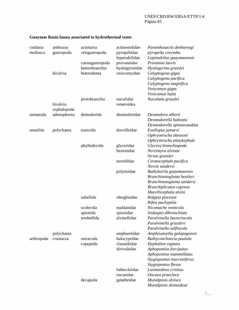
UNEP/CBD/RW/EBSA/ETTP/1/4
Página 65
/…
Guaymas Basin fauna associated to hydrothermal vents
cnidaria anthozoa actiniaria actinostolidae Paranthosactis denhartogi
mollusca gastropoda vetigastropoda pyropeltidae pyropelta corymba
lepetodrilidae Lepetodrilus guaymasensis
caenogastropoda provannidae Provanna laevis
heterobranchia hyalogyrinidae Hyalogyrina grasslei
bivalvia heterodonta vesicomyidae Calyptogena gigas
Calyptogena pacifica
Calyptogena magnifica
Vesicomya gigas
Vesicomya lepta
protobranchia nuculidae Nuculana grasslei
bivalvia veneroidea
cephalopoda
nematoda adenophorea demodorida desmodoridae Desmodora alberti
Desmodorella balteata
Desmodorella spineacaudata
annelida polychaeta eunicida dorvilleidae Exallopus jumarsi
Ophryotrocha akessoni
Ophryotrocha platykephale
phyllodocida glyceridae Glycera branchiopoda
hesionidae Nereimyra alvinae
Sirsoe grasslei
nereididae Ceratocephale pacifica
Nereis sandersi
polynoidae Bathykurila guaymasensis
Branchinotogluma hessleri
Branchinotogluma sandersi
Branchiplicatus cupreus
Macellicephala alvini
sabellida siboglinidae Ridgeia piscesae
Riftia pachyptila
scolecida maldanidae Nicomache venticola
spionida spionidae lindaspio dibranchiata
terebellida alvinellidae Paralvinella bacteriocola
Paralvinella grassleri
Paralvinella sulfincola
polychaeta ampharetidae Amphisamytha galapagensis
arthropoda crustacea ostracoda halocypridae Bathyconchoecia paulula
copepoda clausidiidae Hyphalion captans
dirivultidae Aphopontius forcipatus
Aphopontius mammillatus
Stygiopontus mucroniferus
Stygiopontus flexus
lubbockiidae Laimatobius crinitus
oncaeidae Oncaea praeclara
decapoda galatheidae Munidposis alvisca
Munidposis diomedeae

UNEP/CBD/RW/EBSA/ETTP/1/4
Página 66
/…
crustacea lithodidae Neolithodes diomedeae
thalassinidae
caridea
chordata ostheichthyes perciformes zoarcidae
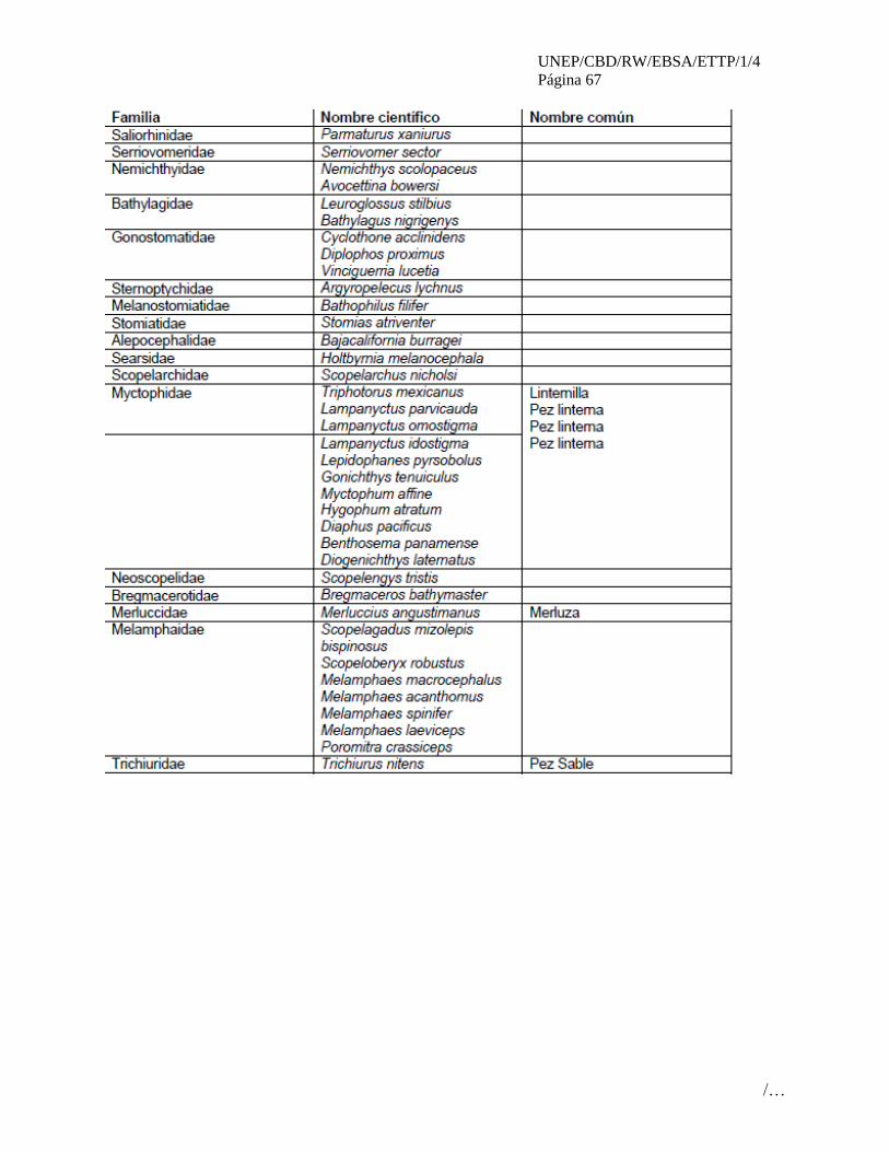
UNEP/CBD/RW/EBSA/ETTP/1/4
Página 67
/…

UNEP/CBD/RW/EBSA/ETTP/1/4
Página 68
/…

UNEP/CBD/RW/EBSA/ETTP/1/4
Página 69
/…

UNEP/CBD/RW/EBSA/ETTP/1/4
Página 70
/…
Rights and permissions
Comisión Nacional de Áreas Naturales Protegidas, 2006. “Estudio Previo Justificativo para el
establecimiento del Santuario Ventilas Hidrotermales de la Cuenca de Guaymas y de la Dorsal del
Pacífico Oriental”. México, D.F., pp. 89 + anexos
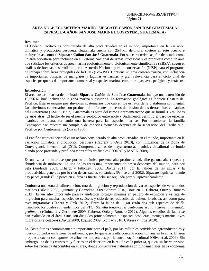
UNEP/CBD/RW/EBSA/ETTP/1/4
Página 71
/…
ÁREA NO. 4: ECOSISTEMA MARINO SIPACATE-CAÑÓN SAN JOSÉ GUATEMALA
(SIPICATE-CAÑON SAN JOSE MARINE ECOSYSTEM, GUATEMALA)
Resumen El Océano Pacífico es considerado de alta productividad en el mundo, importante en la variación
climática y producción pesquera. Guatemala cuenta con 254 km de litoral costero en este océano e
incluye áreas como el Sipacate-Cañon San José Guatemala. Por sus características, fue detectada como
un área prioritaria para incluirse en el Sistema Nacional de Áreas Protegidas y es propuesta como un área
que satisface los criterios de área marina ecológicamente o biológicamente significativa (EBSA), según el
análisis de brechas desarrollado por el Acuerdo Nacional para la conservación (NISP) para el programa
de trabajo sobre áreas protegidas de la CDB (PoWPA). Contiene un área costero-marina, con influencia
de importantes bosques de manglares y lagunas estuarinas, y gran relevancia para el ciclo vital de
especies pesqueras de importancia comercial y especies marinas como tortugas, aves pelágicas y cetáceos.
Introducción El área costero marina denominado Sipacate-Cañón de San José Guatemala, incluye una extensión de
10,556.61 km2 incluyendo la zona marina y estuarina. La formación geológica es Planicie Costera del
Pacifico. Ésta se originó por aluviones cuaternarios que cubren los estratos de la plataforma continental.
Los aluviones cuaternarios son producto de diferentes procesos de erosión de las tierras altas volcánicas
del Cuaternario (ASIES, 1992). Guatemala es parte del istmo Centroamericano que se formó 3.5 millones
de años atrás. El hecho de ser el puente geológico entre norte y Sudamérica permitió el paso de especies
neárticas de fauna, formando una barrera para las especies marinas. Por mencionar, la familia
Centropomidae muestra un complejo de especies formadas después de la separación del Caribe y el
Pacífico por Centroamérica (Rivas 1980).
El Pacífico tropical oriental es un océano considerado de alta productividad en el mundo, importante en la
variación climática y producción pesquera (Cabrera y Ortiz 2010), con influencia de la Zona de
Convergencia Intertropical (ZCI). Comprende zonas de playa arenosa, planicies circalitoral de fondo
blando poco profunda y profunda y arrecifes artificiales (CONAP y MARN 2009).
Es una zona de interfase que por su dinámica presenta alta productividad, alberga una alta riqueza y
abundancia de moluscos. Es una de las áreas más importantes de pesca deportiva del mundo, para pez
vela (Andrade 2003, Erhardt y Fithchett. 2006, Dávila 2011), por la calidez de las aguas y la
productividad generada por lo rico de sus suelos volcánicos (Prince et al 2002). Sipacate significa “donde
hay peces grandes”, la pesca en el área es fuerte, debe ser regulada para su aprovechamiento.
Conforma una zona de alimentación, ruta de migración y reproducción de varias especies de vertebrados
marinos (Dávila 2008, Quintana y Gerrodete 2009 Cabrera 2010, Boix 2011, Cabrera, Ortíz y Romero
2012). Es un sitio importante para la anidación tortugas marinas en peligro de extinción y es ruta de
migración para muchas especies de cetáceos y sitio de reproducción de ballena jorobada, así como para
aves migratorias (Cabera y Ortíz 2012). Entre la fauna del lugar están dos sub especies de delfín
manchado los cuales son endémicos del PTO (Stenella longirostris centroamericana y Stenella attenuata
graffmani) (Quintana y Gerrodete 2009, Cabrera, Ortíz y Romero 2012). Algunos estudios de fauna se
han realizado en el área, estos son dirigidos principalmente a especies pesqueras, tortugas marina, aves
migratorias y cetáceos (Dávila 2009, Ixquiac 2009, Ixquiac 2010, Cabrera y Ortíz 2010).
La Costa Sur es económicamente importante para el país, por las múltiples actividades agroindustriales y
puertos ubicados en la zona de influencia, por lo que existe alta concentración humana en la zona. El área
propuesta cuenta con aportes de afluentes impactados por la eutrofización cultural (Oliva et al. 2009). Sin
embargo una de las causas muy fuertes en el deterioro en la región es la pobreza, que causa fuerte presión
sobre los recursos disponibles en el área, donde los recursos naturales son fundamentales en la economía

UNEP/CBD/RW/EBSA/ETTP/1/4
Página 72
/…
de las familias locales, en especial turismo y pesca. Aprovechamientos de fauna silvestre y el cambio de
uso de suelo como resultado de éstos representan una amenaza para la zona a mediano y largo plazo.
Aunado a esto las políticas presenta un reto para las distintas instituciones involucradas en el manejo de
las zonas costero marinas, que pueden ser entre otras CONAP, INAB, OCRET y la Guardia Naval.
Parte del complejo propuesto como área que satisface los criterios EBSA, aun posee naturalidad y
recursos naturales aprovechables, que son una oportunidad para generar estrategias lógicas y compatibles
de manejo, en la que puedan formar parte las comunidades usuarias y beneficiadas de los mismos, en
actividades de pesca comercial, deportiva y turismo principalmente. Se considera que el complejo
Sipacate – Cañón de San José, es un área prioritaria para incluirse en el Sistema Nacional de Áreas
Protegidas y es propuesta como un área que satisface los criterios de área marina ecológicamente o
biológicamente significativa (EBSA), según el análisis de brechas desarrollado por el Acuerdo Nacional
para la conservación (NISP) para el programa de trabajo sobre áreas protegidas de la CDB (PoWPA).
Ubicación
El área costero marina denominado Sipacate-Cañon de San José Guatemala está localizada en el
Océano Pacífico este, dentro del límite del mar territorial de Guatemala (Figura 1).
Descripción de las características del área propuesta
Descripción física
El complejo Sipacate-Cañón de San José Guatemala, se localiza al Sureste del Pacífico de Guatemala
en la zona de marismas del Litoral del Pacífico. Incluye una extensión 10,556.61 km2, con una morfología
costera dividida en costa y plataforma continental (Jiménez 1994). Los suelos en la zona costera están
formados por deposición de sedimentos de los últimos 6,500 años (Neff et al. 2006) poseen color oscuro
de textura arenosa, arena con gravillas de fragmentos de rocas volcánicas en un 20%, y material arcilloso
en la zona de canales, en la cual se forman diferentes sistemas de deltas, lagunas, barras de arena y
esteros. La zona terrestre aporta sedimentos que modifican constantemente la zona de canal y zona
costera, especialmente durante la época lluviosa (Jiménez 1994, Boix 2011).
El área costera presenta variaciones batimétricas con sitios planos y poco profundos, hasta sitios con altas
pendientes y profundidades máximas alrededor de 2,000 m. según Cabrera y Ortíz (2010). En la costa, en
el borde de la plataforma continental plana se identifica una formación particular de fondo llamada el
Cañón de San José, el cual es un sitio importante para la productividad del área (Ladd et al. 1978). Se
localiza a 30 km de la costa mar adentro donde alcanza una profundidad de 500 m y un ancho de 35 km,
mientras que a 55 km de distancia tiene 1,000 m de profundidad, un ancho de 15 km y a 88 km de
distancia alcanza una profundidad de 2,000 m y un ancho de 5 km (tomado de Boix 2011). El agua
marina en el Océano Pacífico, presenta temperaturas promedio de 30°C, y una salinidad promedio de 34
g/L (Jiménez 1994).
Cuenta con rasgos relevantes como: playas arenosas y rocosas, playas fangosas y sedimentos. Éstos están
influenciados por una rica zona costera compuesta de manglares y sistemas lagunares que permiten una
dinámica ecosistemita compleja (CONAP y MARN 2009), con aportes de agua salada, dulce y
sedimentos entre la zona marina, e intercambio de nutrientes y especies (Jiménez 1994, Boix 2011).
En general la costa sur, está altamente afectada por la contaminación proveniente de la cuenca. Esta zona
en particular recibe descargas directas del río María Linda, que viene desde una zona industrial, además
de ubicarse muchas poblaciones en toda el área (FAO 1987). Parámetros como los nitratos, amonio y
UNEP/CBD/RW/EBSA/ETTP/1/4
Página 73
/…
fósforo total sobrepasan los límites permisibles para aguas no contaminadas según EPA en sistemas
lagunares de influencia (Canal de Chiquimulilla) (Oliva et al. 2007), estas condiciones tienen impacto en
la zona marina.
Comunidades biológicas y función del ecosistema
El área costero marina denominada Sipacate-Cañón de San José Guatemala, muestra playas arenosas y
rocosas, playas fangosas, sedimentos y una formación especial, denominada el Cañón de San José, que se
encuentra mar adentro, la cual propicia condiciones físicas adecuadas para la disponibilidad de alimento.
Forma parte de la provincia íctica Chiapas –Nicaragua (Miller 1966), que presenta una serie de
características similares en cuanto a hábitat, influencia de corrientes, composición de especies y procesos
eco sistémicos regionales (CONAP y MARN 2009, Estrada et al. 2012).
Por sus características, la zona marina y costera del Pacífico, es un sitio importante por la diversidad
biológica que albergan en los diferentes ecosistemas que se forman. Entre la fauna del área, existen
especies residentes y migratorias de vertebrados, algunos en estatus crítico de conservación, los cuales
son de importancia en procesos del ecosistema, e importancia socio-económica.
De acuerdo al inventario de vegetación del área realizado por Cabrera, Dávila y Morales (2012) existen
especies vegetales que permiten la estabilización de las dunas disminuyendo la erosión natural ocasionada
por el viento y las mareas. Los manglares de influencia del ecosistema, son relevantes por constituir la
base de muchos procesos ecológicos y por ser parte fundamental en el ciclo vital de muchas especies, al
menos una parte del mismo (Sigüenza y Ruíz-Ordoñez, 1999).
Existen especies pesqueras de importancia económica y ecológica, muchas de las especies poseen ciclos
de intercambio entre la zona marina y costera (Quintana 2007). Existen almenos 15 especies de moluscos
que son aprovechados en la Costa Sur (CONAP 2008).
Es la segunda una zona de pesca de arrastre de camarón (Las Lisas-la Barrona). Es un complejo
importante para especies pesqueras de importancia ecológica y comercial, de familias tales como
Centropomidae (snook), Scianidae (weakfish), Lutjanidae (snnaper), Ariidae (catfish), Caranjidae,
especialmente para pez dorado (Coryphaena hippurus), Scombridae (tunas) y familia Istiophoridae
(Marlin y Pez Vela) que tiene importancia en pesca deportiva (Boix 2011).
Es considerado el sitio con mayor diversidad y abundancia de batoideos para el Pacífico de Guatemala
(Ixquiac 2009). Recientemente se reportó la presencia de al menos 10 especies, de las cuales 3 presentan
una mayor biomasa en pesca incidental, aunque también son comercializadas: Longtail stingray (Dasyatis
longa), Whiptail stingray (Dasyatis brevis) y Pacific Cownose Ray (Rhinoptera steindachneri).
Es un sitio importante en la crianza de tiburones, se reportan al menos 15 especies en desembarques
pesqueros. Se considera un sitio importante para la tallas juveniles de tiburones, especialmente para
tiburón martillo -Scalloped hammer head (Sphyrna lewini), la cual junto con el smooth hammerhead
(Sphyrna sygaena), son especies vulnerables según la UICN (2012).
. Existen otras especies vulnerable (UICN 2012) como: Pelagic thresher (Alopias pelagicus), Smooth
hammerhead (Sphyrna mokarran) y Whitetip oceanic shark (Carcharhinus longimanus). Entre las species
consideradas Near threatened or Data Deficient, por la UICN estan: Silky shark (Carcharhinus
falciformis), Blacktip shark (Carcharhinus limbatus), Whitenose shark (Nasolamia velox), Mexican
hornsharrk (Heterodontus mexicanus), Nurse shark (Ginglymostoma cirratum), Blue shark (Prionace
glauca), tiger shark (Galeocerdo cuvier) y Bull Shark (Carcharhinus leucas). Entre las especies de
batoideos se pueden mencionar Giant Electric Ray (Narcine entemedor), Spiny-tail Round Ray
UNEP/CBD/RW/EBSA/ETTP/1/4
Página 74
/…
(Urotrygons aspidura), Longtail stingray (Dasyatis longa) y Equatorial skate (Raja equatorialis); y
Whiptail stingray stingray (Dasyatis brevis).
Istiophorus platypterus (pez vela), es una especie distribuida en el área centroamericana porque presenta
las condiciones ambientales favorables para su sobrevivencia (Ehrhardt and Fitchett 2006, OSPESCA
2007). El área propuesta representa un punto importante para pez vela donde se desarrolla una de las
actividades de pesca deportiva más importantes a nivel mundial.
En la zona marina, se reportan varias especies de vertebrados migratorios, entre los que destacan
especies de importancia ecológica (consumidores primarios y depredadores, y transporte de nutrientes).
La franja de playa, es de vital importancia para el desove de tortugas marinas durante la temporada de
julio a diciembre de cada año (Sigüenza y Ruíz-Ordoñez 1999). Se reporta la presencia de especies de
tortugas marinas, todas amenazadas, y en estado crítico de conservación (UICN 2012): Lepidochelys
olivacea (parlama blanca), Chelonia spp. (parlama negra) y Dermochelys coriacea (baule) (Dix y
Hernández 2001); y aunque Eretmochelys imbricata no es frecuente para Guatemala, existen reportes en
la Costa Sur ya que esta cercano al principal sitio de reportes para la especie, en El Salvador (Gaos et al
2010).
La zona de Las Lisas es sitio de anidación para dos especies de tortugas marinas en peligro de extinción
(Dermochelys coriácea y Lepidochelys olivacea) que anidan en las playas del sitio y como especie rara se
reporta la especie Carreta m. agassizii (CONAP S/A, Dávila 2011, López y del Cid 2011), y para
Sipacate se reportan 3 especies (Dermochelys coriácea, Eretmochelys imbricata, Lepidochelys olivácea )
que anidan en la zona, así como fenómeno muy especial la tortuga verde o negra Chelonia spp. Hace uso
de la Poza del Nance aunque no se reportan desoves en las playas cercanas.
Se reportan 11 especies de cetáceos (Cabrera y Ortíz 2010, Dávila 2011), entre ellos dos subspecies
exclusivas del Pacifico tropical oriental (PTO): Stenella longirostris centroamericana y Stenella
attenuata graffnmani. Siendo la especie más común Tursiops truncatus. Representa un sitio relevante
para la reproducción y crianza de ballenas jorobadas durante su migración (Cabrera y Ortiz 2010, Dávila
2011). El cañón de San José, ha sido identificado como un área de importancia en procesos ecosistemicos
y alta productividad, asociado a este se reportaron 7 especies de cetáceos frecuentes (Cabrera y Ortíz
2010).
Asociados a sitios con disponibilidad de alimento, presencia de tortugas marinas y cetáceos, se encuentran
los grupos de aves pelágicas (Velásquez 2008, Del Cid & López 2011). Se reportan como aves de la zona
litoral Procellaria parkinsoni, Puffinus auricularis, Puffinus griseus, Puffinus pacificus, Oceanites
oceanicus, Puffinus nativitatis, Stercorarius longicaudus, Stercorarius maccormicki, reportándose estas
últimas tres como especies raras. En la zona costera y marina se reportan Puffinus creatopus Puffinus
lherminieri, Oceanodroma Melania, Oceanodroma microsoma, Oceanodroma tethys, Sula leucogaster,
Stercorarius parasiticus, Stercorarius pomarinus. Y Oceanodroma Leucorhoa, Sula dactylatra, Sula
granti (común), Sula sula, en la zona marina.
Información que está disponible
Existen estudios de especies pesqueras relacionados con movimientos migratorios, aprovechamiento
pesquero, estudios ecológicos y especies migratorias de aves y megafauna en la zona costera.
En relación a la cuantificación de extracción de recursos pesqueros, existen datos de 1975, estimando una
extracción viable 10,000 Tm/año del recurso pesquero en la costa sur, sin embargo indicios de sobre
explotación del recurso fueron identificados en el caso de la pesca de camarón (FAO 1987). Existen
pocos estudios recientes y la mayoría se enfocan en aspectos biológicos, ecológicos y particularidades de

UNEP/CBD/RW/EBSA/ETTP/1/4
Página 75
/…
pesca. Entre los estudios realizados se puede mencionar el realizado por Ehrhardt y Fitchett (2006) con
pez vela, relacionado con movimientos migratorios de la especie. Ixquiac y colaboradores (2007),
investigaron la “Identificación, abundancia y distribución espacial de Batoideos (Rayas) en el Pacífico
guatemalteco”, generando información de la ecología de 15 especies de rayas, 3 de ellas, nuevos reportes
para el país. Posteriormente realizo el proyecto “Área de crianza de tiburones en la plataforma continental
del Pacífico de Guatemala: herramienta para el manejo y aprovechamiento sostenido del recurso tiburón”,
identificando 3 zonas importantes para crianza, en especial para tiburón martillo.
Existen algunos estudios de tortugas marinas, relacionados en el manejo y amidación de tortugas en las
playas de la costa sur, y muchos trabajos se han enfocado en esta área propuesta (Higginson y Orantes
1987, Mucio 1998, Rivas 2002, Montes 2004, Sánchez, Jolón y Girón 2005).
Sigüenza, Velásquez y Dávila (2009) identificaron 24 especies de aves pelágicas entre ellas 4 especies de
la familia Procellaridae, 6 de la familia Hydrobatidae, 5 de la familia Sulidae, y 4 de la familia
Stecoraridae. Algunas de estas especies se han observado asociadas a cetáceos (Dávila, 2011). Según
datos de Sigüenza, Velásquez y Dávila (2009) seis de estas especies protagonizan episodios de captura
incidental por actividades pesqueras artesanales siendo estas el salteador parásito (Stercorarius
parasiticus), el salteador pomarino (Stercorarius pomarinus), el bobo (Sula sp.), la pardela (Puffinus
creatopus), la pardela (Puffinus lherminieri), y pelicano (Pelecanus sp).
Pocos estudios se han realizado con mamíferos marinos en Guatemala, recientemente Quintana-Rizzo y
Gerrodette (2009), realizaron el primer estudio sobre la diversidad, distribución y abundancia de cetáceos
en la zona económica exclusiva del Océano Pacífico de Guatemala. Cabrera y Ortiz (2010) reportan
observaciones de 8 especies de cetáceos, encontrando patrones de distribución y uso de hábitat en el
sureste de la zona costera concentrados principalmente en el Cañón de San José, otras menciones de
avistamientos son reportadas en los trabajos de Dávila (2009, 2011) y Sigüenza (2009) los cuales ha
dirigido hacia megafauna y captura incidental de vertebrados marinos en el pacífico, donde se reporta la
captura incidental de cetáceos, tiburones, batoideos, tortugas marinas y peces picudos.
Condición de las características y perspectivas a futuro de la zona propuesta
Los humedales costeros del Pacífico suroriental del país, son considerados altamente productivos y con
potencial de aprovechamiento sostenible relacionado principalmente con actividades turísticas (García y
Franco 2008). Sin embargo esta zona especialmente está sometida a degradación por influencia humana
(CONAP y MARN 2009). El complejo Sipacate-Cañón San José Guatemala se encuentra en un área
económicamente importante para el país donde las actividades productivas están relacionadas con la
agroindustria, camarones y salineras, y desarrollo de puertos marítimos, lo cual ha generado una alta
concentración humana y el desarrollo de centros urbanos de importancia, que hacen uso intensivo y
generan un severo impacto sobre los ecosistemas (FUNDAECO 2002, Boix 2011).
En el análisis de vacíos, desarrollado por el Acuerdo Nacional para la conservación (NISP) del programa
de trabajo sobre áreas protegidas de la CDB (PoWPA), se identificó como principales amenazas para el
área que incluye a Sipacate-Cañón San José Guatemala: Contaminación por áreas urbanas, ganadería,
caminos e infraestructura portuaria, erosión, camaroneras y salineras, vías de acceso, densidad
poblacional, pérdida de cobertura de mangle, pesca de arrastre (CONAP y MARN 2009). También se han
identificado como amenazas la deforestación y azolvamiento de los sistemas estuarinos y la explotación
sin manejo adecuado de los recursos naturales (huevos de tortuga y sobrepesca) (FUNDAECO 2002).
Los poblados de la Costa Sur dependen en gran medida de los recursos naturales (Boix 2011). El mangle
es muy utilizado con fines domésticos, se ha estimado un aprovechamiento de mangle para leña en US$35

UNEP/CBD/RW/EBSA/ETTP/1/4
Página 76
/…
mil/año en la costa Sur (CONAP y MARN 2009). En general, es uno de los bosques más degradados, con
pérdidas del 70% en los últimos 50 años, sin embargo esfuerzos de conservación han logrado una
recuperación reciente de 11% (2000-2007) (CONAP y MARN 2009). Una pérdida de cobertura de
manglar de 735.5 hectáreas de 1945 a 1999 a razón de 16.39 ha/año se reporta en el área Iztapa-
Monterrico (tomado de García et al. 2000).
Sus características permiten una comunidad íctica muy rica, la cual es aprovechada por las comunidades.
La pesca comercial ha generado alrededor de US $49 M (CONAP y MARN 2009). La pesca deportiva de
pez vela para el 2007 generó alrededor de US $5 millones en 6 meses durante el 2007 en el área de Iztapa
y San José (El Periódico 2008). Su pesca en general está prohibida para aprovechamiento que no sea
deportivo, sin embargo se reportan capturas por pescadores que venden su carne en el mercado (Dávila
comunicación personal).
La pesca tiene como objeto varias species de tiburón, sin discriminación de tallas, se han reportado fuertes
capturas de neonatos y juveniles que no han logrado reproducirse, lo cual pone en riesgo sus poblaciones.
Entre las especies Endangered (UICN 2012) están el Scalloped hammerhead (Sphyrna lewini) y smooth
hammerhead (Sphyrna zygaena). Existen especies vulnerable (UICN 2012) como: pelagic thresher
(Alopias pelagicus), smooth hammerhead (Sphyrna mokarran) y whitetip oceanic shark (Carcharhinus
longimanus). Entre las species consideradas Near threatened or Data Deficient estan: Silky shark
(Carcharhinus falciformis), Blacktip shark (Carcharhinus limbatus), Whitenose shark (Nasolamia velox),
Mexican hornsharrk (Heterodontus mexicanus), Nurse shark (Ginglymostoma cirratum), Blue shark
(Prionace glauca), tiger shark (Galeocerdo cuvier) y Bull Shark (Carcharhinus leucas).
Este complejo es el mas diverso y abundante en batoideos, algunos de estos son capturados en la pesca
incidental de camarón y otras artes de pesca artesanal. Algunos batoideos están reportados con estatus de
Near Treathened: Smoothtail Devil Ray (Mobula thurstoni), spotted Eagle ray (Aeobatus narinari),
pacific cownose ray (rhionoptera steindachneri), whitesnout guitarfish (Thinobatos leucorhynchus). El
resto de species no se encuentran amenazadas o los datos son deficientes para definir un estatus.
Muchas especies de peces de importancia comercial y deportiva han sido aprovechados de manera que
pone en riesgo su permanencia a largo plazo (p.ej. pargo y pez vela), mostrando incluso reducciones de
talla a nivel comercial y una reducción del 80% en las poblaciones de pez vela en los últimos 35 años
(Andrade 2003, Ehrhardt y Fitchett 2006). Se estiman pérdidas en fauna de acompañamiento en pesca de
arrastre de camarón, entre US $5 y 66 M/año (período 2002-2005) (CONAP y MARN 2009). Los
pescadores en su mayoría están conscientes que debe protegerse el ecosistema de manglar para mantener
disponible el recurso pesquero, procesos ecosistémicos, evitar problemas nocivos para sus comunidades
(García y Franco 2008), pero el control de pesca a nivel marino es muy dificultuoso.
Las comunidades rurales realizan comercio de huevos de tortuga marina, se ha estimado que esta
actividad genera US $126 mil en promedio a las comunidades en la Costa Sur (CONAP y MARN 2009).
Es una actividad de aprovechamiento que pone en riesgo la sobrevivencia de estas especies, ya que sus
poblaciones se han reducido los últimos 50 años. Al contrario la demanda de huevos se ha incrementado,
en especial, en el Pacífico este, done las personas reportan menos avistamientos de anidación (Higginson
J. 1989). Existen esfuerzos de conservación de tortugas marinas, dirigidas por la estrategia Nacional para
el Manejo y Conservación de las tortugas marinas en Guatemala (ENTM) (Sánchez et al 2002).
Instituciones como CONAP, CECON y ARCAS, han desarrollado tortugarios para incubación de huevos.
Sánchez y colaboradores (2006) propusieron un Protocolo nacional de monitoreo de poblaciones de

UNEP/CBD/RW/EBSA/ETTP/1/4
Página 77
/…
tortugas marinas. Sin embargo, aunque existan programas de tortugarios, no se sabe mucho de la
ecología de este grupo, y los esfuerzos para conservarlo han sido muy débiles (Sánchez et al 2002).
Por otro lado, aunque no son especies objeto de pesca en Guatemala, ocurre pesca incidental por aparejos,
palangres de superficie y pesca fantasma (aparejos de pesca perdidos). Esta captura es principalmente de
cetáceos (en especial de delfin manchado, delfin listado y delfin común), tortugas marinas, batoideos,
tiburones y aves pelágicas (Dávila 2009). A pesar de los esfuerzos de conservación que incluyen el uso de
dispositivos que evitan la captura de tortugas en las redes, algunas embarcaciones de pesca de arrastre no
lo utilizan.
La belleza escénica y la atracción de los recursos naturales, generan un potencial de turismo. La visita de
pescadores deportivos y el avistamiento de cetáceos genera más de US $1,055.00 al año. El
aprovechamiento de los recursos naturales al ser parte fundamental de la economía de las comunidades
locales y sector privado que desarrolla actividades de pesca y turismo en el lugar, presenta oportunidades
de empleo y uso sostenible de los recursos, lo cual puede ser maximizado para beneficio de las
comunidades locales y la conservación de los recursos del lugar.
Evaluación del área sobre los criterios EBSA del CDB
Criterios
CBD EBSA
(Anexo I de la
decisión IX/20)
Descripción
(Anexo I de la decisión IX/20) Clasificación de los criterios
pertinentes
No lo se Bajo Alguno Alto
Características
únicas, rarezas
Área de singularidad o rareza contiene ya sea
(i) exclusivas («la única de su clase"), raras
(sólo ocurre en pocos lugares) o de especies
endémicas, poblaciones o comunidades, y / o
(ii) único, raro o distinto, los hábitats o los
ecosistemas, y / o (iii) características
geomorfológicos u oceanográficos exclusivos
o desacostumbrados.
X
Explicación para la clasificación
Endemismo de las subspecies exclusivas del Pacifico tropical oriental (PTO): Stenella longirostris
centroamericana y Stenella attenuata graffnmani Se reporta como especies raras en el área Ziphus
cavirostris, Mesoplodon sp. Feresa attenuata, y Orcinus orca.
Es uno de los principales sitios de crianza de tiburones, en especial para tiburón martillo (Sphyrna
lewini).
Uno de los sitios con mayor abundancia y riqueza de batoideos para el país.
Concentración de poblaciones de pez vela (Istiophorus platypterus) relevante a nivel mundial.
El cañón submarino profundo conocido como el cañón de San José (Ladd et. al 1978), es un
hábitat para las ballenas jorobadas (Megaptera novaeangliae) que permanecen en el área.
La zona de Iztapa, incluida en el área, es el único sitio donde se reporta tiburón ballena para
Guatemala.
Reportes indican que el Cañon de San José, es un área potencial para la conservación de
cetáceos, la mayoría de avistamientos ocurren en sus proximidades (Cabrera et al. 2010).
Importancia
especial para
las etapas del
ciclo biológico
Las áreas requieren una población para
sobrevivir y prosperar.
X

UNEP/CBD/RW/EBSA/ETTP/1/4
Página 78
/…
de especies
Explicación para la clasificación
La productividad de la zona y sus cualidades ambientales, hacen que el sitio sea importante para diversos
grupos de especies marinas, en especial durante sus migraciones.
Diversas especies de peces marinos, utilizan durante una parte de su ciclo la zona costera
(reproducción y alimentación) y en la zona marina.
Sus aguas cálidas forman parte de la ruta migratoria de pez vela (Istiophorus platypterus).
Es una de las zonas más importantes para la crianza y reproducción de tiburones, en
especial tiburón martillo (Sphyrna lewini).
Las playas son sitios de anidamiento para tortugas marinas Dermochelys coriácea y
Lepidochelys olivácea, Eretmochelys imbricata, Chelonia spp
Es un sitio importante para las poblaciones de al menos 15 especies de tiburones, entre las
cuales se encuentran individuos de todas las tallas, incluyendo neonatos y especies
amenazadas
Por sus características es un hábitat importante para la comunidad de batoideos en la costa
sur.
La zona costera es visitada por 8 especies de cetáceos, al menos 6 especies la utilizan dentro de su ruta
migratoria para alimentación y comportamientos sociales. Ballenas jorobadas del norte tienen
actividades de reproducción y crianza de noviembre a abril, se tienen reportes de ballenas del sur. Se
ha detectado que algunos individuos tienen fidelidad a este sitio.
Importancia de
especies
amenazadas, en
peligro o en
declive y/o
hábitats
Áreas que contienen hábitat para la
supervivencia y recuperación de especies en
peligro, amenazadas, especies en declive o
área con agrupamientos significativos de tales
especies.
X
Explicación para la clasificación
Su zona costera contiene un remanente de manglares importante y vulnerable,
principalmente con mangle rojo Rizophora mangle.
Es un sistema de intercambio marino costero, que permite los ciclos vitales completos de
varias especies pesqueras y alimentación de especies migratorias, muchas de las cuales tienen
poblaciones vulnerables por la explotación del recurso, el cual se ha visto reducido los
últimos años (i.e. pargo y pez vela).
Es un hábitat de importancia para la crianza de tiburones, existen 15 especies reportadas y
consideradas en la UICN:
Endangered: Scalloped Hammerhead (Sphyrna lewini), Squat-headed hammerhead shark
(Sphyrna mokarran ) Vulnerable: pelagic thresher (Alopias pelagicus), Smooth hammerhead (Sphyrna zygaena.)
Near threatened: Silky shark (Carcharhinus falciformis), blacktip shark (Carcharhinus limbatus),
blue shark (Prionace glauca), tiger shark (Galeocerdo cuvier), bull shark (Carcharhinus leucas)
Data deficient: whitenose shark (Nasolamia velox), Mexican honrnsahrk (Heterodontus mexicaus),
Nurse shark (Ginglymostoma cirratum).
Se ha reportado como un sitio importante para la riqueza y abundancia de 10 especies de
batoideos, entre los cuales 5 especies se consideran casi amenazados (UICN) y el resto de
especies no se tienen datos suficientes para establecer su estatus.
Sus playas son parte del ciclo vital de tortugas marinas amenazadas y consideradas en el

UNEP/CBD/RW/EBSA/ETTP/1/4
Página 79
/…
convenio CITES y lista roja internacional: Dermochelys coriácea y Lepidochelys olivácea.,
que usan las playas para anidar.
Todos los cetáceos de la familia Delphinidae están en el nivel 2 de la lista de especies
amenazadas del país y el apéndice 3 de CITES. 2 cetáceos de la familia Balaenopteridae se
encuentran en el nivel 2 de la LEA y apéndice 1 de CITES.
Vulnerabilidad,
fragilidad,
sensibilidad, o
Áreas de lenta
recuperación
Áreas que contengan una proporción
relativamente elevada de hábitats sensibles,
biotopos o especies que son funcionalmente
frágiles (altamente susceptibles a la
degradación o agotamiento por actividades
humanas o por acontecimientos naturales) o
con una lenta recuperación.
X
Explicación para la clasificación
Los manglares han sido degradados por el cambio de uso de la tierra para salineras,
camaroneras y fincas, asi como para aprovechamiento de madera. La zona sureste es la mas
contaminada por efecto de agroindustria, poblados y erosion. Esto ha alterado la dinámica
natural del sistema, principalmente en la calidad del agua, que ha mostrado valores de
parámetros químicos fuera de los límites permisibles por EPA, especialmente nutrientes.
Explotacion de los recursos naturales se realiza de una manera no sostenible. La colecta con fines
comerciales de huevos de tortuga marina, ponen en riesgo las poblaciones de las mismas, esto
amenazante ya que todas son especies amenazadas con poblaciones vulnerables.
La pesca artesanal de enmalle y la pesca de arrastre de camarón, se realizan de manera
desordenada. Esta pesca no discrimina tallas, e incluso son capturados peces de bajo tamaño. En el
caso de las poblaciones de tiburones, muchas de ellas están en alguna categoría de la lista roja
mundial, sin embargo se pescan individuos neonatos y juveniles que no logran reproducirse. La pesca
de arrastre tiene impacto en la megafauna marina, se ha reportado captura de tortugas, aves pelágicas,
tiburones, rayas y cetáceos. Estas especies también son afectadas por la pesca fantasma.
En el caso de los cetáceos, algunos son capturados para utilizar su carne para carnada para la
captura de tiburones.
Productividad
biológica
Área que contiene especies, poblaciones o
comunidades con relativamente mayor
productividad biológica natural.
X
Explicación para la clasificación
Es una zona altamente productiva, esto incide en la cantidad y calidad del producto pesquero,
incluyendo camarón.
El sitio muestra una de las poblaciones más importantes de pez vela
Importantes poblaciones de tiburones usan el sitio para crianza.
Es uno de los sitios más importantes para riqueza y abundancia de batoideos para el Pacífico
del país.
El cañón de San José muestra ser un área especial en la productividad, esto es importante
para diversas especies de peces, aves migratorias, tortugas marinas y cetáceos que
permanecen o migran en la costa del país.
Diversidad
Biológica
Área que contiene una diversidad
relativamente superior de ecosistemas,
hábitats, comunidades, o especies, o tiene una
X

UNEP/CBD/RW/EBSA/ETTP/1/4
Página 80
/…
mayor diversidad genética.
Explicación para la clasificación
La zona de manglares está formada por 4 especies de mangle, es un sitio de anidación,
refugio y alimentación de varias especies de aves acuáticas.
Se han reportado 6 especies de camarón, siendo la más importante Xiphopenaeus riveri y
Panaaeus vannamei.
Se reportan varias especies marinas como Spotted rose snapper (Lutjanus guttatus),
Common Dolphinfish (Coryphaena hippurus), Sailfish (Istiophorus platypterus) Striped
weakfish (Cynoscion reticulatus), Carangidae, tuna (Thunnus sp.), entre otros
Al menos 3 especies de tortugas marinas usan las playas para sitio de anidación:
Dermochelys coriácea y Lepidochelys olivácea.
La ictiofauna está compuesta por varias especies de importancia comercial como robalo,
dorado, pargo, múgiles y jureles entre otras especies marinas reportadas en el Pacífico de
Guatemala. Especies de pesca deportiva como pez vela y marlín, usan este hábitat durante
sus migraciones.
Es el único sitio donde se ha reportado tiburón ballena.
Se han reportado 15 especies de tiburones y 10 especies de batoideos.
Existen reportes de 8 especies de cetáceos (delfin nariz de botella Tursiops truncatus,
delfin manchado pantropical Stenella longirostris, delfin común Delphinus delphis, delfin
Risso Grampus griseus, delfin de dientes rugosos Steno bredanensis, ballena jorobada
Megaptera novaeangliae y ballena de Bryde o rorcual tropical Balaenoptera edeni).
Naturalidad Área con un grado relativamente mayor de
naturalidad como resultado de la falta o bajo
nivel de perturbación de origen humano o
degradación.
X
Explicación para la clasificación
El área es ampliamente utilizada por las comunidades locales que han desarrollado la urbanización en el
lugar, así como producciones de sal y camaron. Tanto la parte costera como marina es un refugio para
muchas especies que suelen ser aprovechadas por los comunitarios, es una zona donde la pesca y el
turismo son actividades muy fuertes. Existe mucha presión en el área, ya que es de fácil acceso y con alto
flujo de turismo por lo que los paisajes de manglares son escenarios aprovechados, pero fuertemente
impactados.
Intercambio de experiencias e información aplicando otros criterios
Otros criterios Descripción Clasificación de los criterios
pertinentes
No lo se Bajo Alguno Alto
Equitable Access
and Benefit
Sharing (ABS) for
all goods from
nature (oceans).
It is important to find a right balance
between the natural productivity of the sea
for industry and local livelihoods especially
in areas beyond national jurisdiction, in
accordance with national and regional
policies and the CBD objectives.
X
Explicación para la clasificación
Las comunidades locales viven de la explotación de los recursos naturales, sus actividades van desde la
extracción de los mismos (mangle, especies pesqueras, vida silvestre, elementos para artesanía), hasta la

UNEP/CBD/RW/EBSA/ETTP/1/4
Página 81
/…
mano de obra en trabajos de salineras, camaroneras y servicios turisticos en el sector privado, al igual que
en algunas flotas pesqueras industriales. Se tiene conocimiento de algunos de los beneficios que el área
brinda a las comunidades locales, pero no se tiene certeza de un acceso equitativo de los recursos o del
impacto que tengan las actividades lucrativas del sector privado en el lugar. En el caso del turismo las
empresas privadas son las que más tienen la oferta, y emplean personas locales para su desarrollo.
Referencias
Andrade, H. 2003. Age determination in the snapper Lutjanus guttatus (Pisces,
Lutjanidae) and investigation of fishery management strategies in the Pacific Coast of
Guatemala. Departament of Aquatic Biosciences. Norwegian college of Fisheries
Science. University of Tromso. 46 pp.
Arrivillaga, A. and N. Windevoxhel. 2008. Mesoamerican Reef Ecoregional Assessment:
Marine Conservtion Plan. The Nature Conservancy, Guatemala. 30p. + Annexes.
ASIES.1992.Monografía Ambiental – Región Central (Chimaltenango, Escuintla y
Sacatepequez), Coordinado por G. Mayen, M. Arrecis, R. Arriaza, y A. Castillo.
Asociación de investigación y Estudios Sociales. ASIES, Guatemala.
Boix, L. 2011 Elementos para contribuir a la gestión integrada de zonas costeras del
Pacífico de Guatemala. I. Área de trabajo: Humedal las Lisas, Chiquimulilla,
Departamento de Santa Rosa. 170 pp
Cabrera, A., y J. Ortíz. 2010. Cetáceos de la costa pacífica de Guatemala: Parte I:
Pacífico Este. Consejo Nacional de Áreas Protegidas. Fondo Nacional para la
Conservación de la Naturaleza. 38 pp.
Cabrera, A. y J. Ortíz. 2012. Cetáceos de la costa pacífica de Guatemala, Parte II:
Pacífico Central. Consejo Nacional de Áreas Protegidas. Fondo Nacional para la
Conservación de la Naturaleza. 51 pp
CONAP 2009. Lista De especies amenazadas de Guatemala –LEA- y listado de especies
de Flora y fauna silvestre CITES de Guatemala. 2da. Edicion. Consejo Nacional de Areas
Protegidas. Guatemala. 124 pp.
CONAP y MARN. 2009. Biodiversidad Marina de Guatemala: Análisis de Vacíos y
Estrategias para su Conservación. Consejo Nacional de Áreas Protegidas, Ministerio de
Ambiente y Recursos Naturales, The Nature Conservancy. Guatemala. 152p.
(www.conap.gob.gt) CONAP. 2011. Política Nacional de Diversidad Biológica. Acuerdo Gubernativo 220-
2011. Consejo Nacional de Áreas Protegidas. Guatemala. Políticas, Programas y
Proyectos No13 (01-2011). 41p.
Dávila-Pérez, V. 2008. Propuesta metodológica para la documentación de megafauna
pelágica (Tortugas Marinas, delfines, ballenas, peces pico y rayas) en el Pacífico de
Guatemala. Programa de Ejercicio Profesional Supervisado. Escuela de Biología.
Universidad de San Carlos de Guatemala. Consultado en la red:
http://www.scribd.com/doc/28541851/Propuesta-Metodologica-para-la-documentacion-de-avistamientos-de-Megafauna-Pelagica-en-el-Pacifico-de-Guatemala-2008
Dávila, V. Velásquez, P. y R. Sigüenza. 2009. Diagnóstico de Captura incidental de Aves
Marinas en el Pacífico de Guatemala, Centro América. Informe Final. Universidad de
San Carlos de Guatemala y Pacific Seabird Group. 61 pp.
UNEP/CBD/RW/EBSA/ETTP/1/4
Página 82
/…
Dávila, V. 2011. Diversidad y abundancia de la megafauna pelágica (ballenas, delfines, tortugas marinas, peces pico y rayas). Tesis de grado para optar al título de Bióloga. Escuela de Biología. Universidad de San Carlos de Guatemala. 136 pp.
Estrada, C., García, M., Machuca, O. y D. Bustamante 2012. Análisis de la efectividad
ecológica de los espacios terrestres incluidos en el Sistema Guatemalteco de Áreas
Protegidas (SIGAP). Facultad de ciencias Químicas y Farmacia. Dirección general de
Investigación. Universidad de San Carlos de Guatemala.
FAO. 1987 LA SITUACION DE LA PESCA Y ACUICULTURA EN GUATEMALA Y
LOS LINEAMIENTOS PARA SU DESARROLLO FUTURO (Informe Terminal de
Consultoría) Período del 14 de julio al 1 de septiembre de 1986(2a. Versión). Consultado
en: http://www.fao.org/docrep/field/003/AC587S/AC587S00.htm#TOC
FAO 1998. Programa de Asesoramiento en Ordenacion y legislación Pesquera. Informe
Preparado para el Gobierno de la República de Gautemala sobre el Análisis del Sector de
la Pesca y la Acuicultura en Guatemala (con énfasis en la pesquería artesanal). Informe
de Campo 92 Organización de las Naciones Unidas para la Agricultura y la
Alimentación.
FUNDAECO. 2002. Propuesta técnica: Corredor Biológico Costa Sur Canal de
Chiquimulilla. FUNDAECO-ONCA. Guatemala. 57 pp
Gaos, A, Abreu-Grobois, F. Alfaro-Shigueto,J., Amorocho, D., Arauz, R., Baquero, A.,
Briseño, R., Chachón, D., Dueñas, C., Hasbún, C., Liles, M., Mariona, G., Muccio, C.,
Muñoz, C., Muñoz J. Nichols, W., Peña, M., Seminoff, J., Vásquez, M., Urteaga, J.
Wallace, B., Yañez I. y P. Zárate. 2010. Signs of hope in the eastern Pacific: international
collaboration reveals encouraging status for a severely depleted population of hawksbill
turtles Eretmochelys imbricate. Fauna / Flora International, Oryx 1-7
García, P., Taracena, J., Marroquín, E. y E. Aceituno. 2000. Bases ecológicas de las
funcionalidades del ecosistema manglar del pacífico de Guatemala. Dirección General de
Investigación. Centro de Estudios del Mar y Acuicultura. Universidad de San Carlos de
Guatemala.
García P. e I. Franco. 2008. Valoración Económica y ordenamiento natural del modelado
del complejo de humedales marino – costeros comprendidos entre el municipio de Iztapa,
Escuintla y la Aldea La Candelaria, Taxisco, Santa Rosa con fines de aprovechamiento
sustentable. Centro de Estudios del Mar y Acuicultura. Dirección General de
Investigación. Universidad de San Carlos de Guatemala. 123 pp
Documento Técnico No. 3. 76 p.Higginson J. 1989. Sea turtles in Guatemala: Threats and
Conservation Efforts. Marine Turtle Newsletter 45: 1-5.
Ixquiac, M. 2010. Identificación, abundancia, distribución espacial de batoideos (rayas)
en el Pacífico Guatemalteco. Centro de Estudios del Mar y Acuicultura, Universidad de
San Carlos de Guatemala, Consejo Nacional de ciencia y Tecnología. 52 pp
Ixquiac. M. 2009. Áreas de crianza de tiburones en la plataforma continental del Pacífico
de Guatemala: Herramienta para el manejo y aprovechamiento sostenido del recurso
tiburón. Centro de Estudios del Mar y Acuicultura, Universidad de San Carlos de
Guatemala, Consejo Nacional de ciencia y Tecnología. 68 pp.
Jiménez, J. 1994. Los manglares del Pacífico Centroamericano. Costa Rica: Universidad
Nacional. Costa Rica.

UNEP/CBD/RW/EBSA/ETTP/1/4
Página 83
/…
Juárez, D. y Y. Quintana. 2012 “Distribución y estado de conservación de la nutria de río
(Lontra longicaudis, Olfers 1818) en los humedales del Sistema Guatemalteco de Áreas
Protegidas y su conservación”. Proyecto FODECYT 15-2009 89 pp
Neff, H., Pearsall, D., Jones, J., Arroyo, B., y D. Freidel. 2006. Climate change and
population history in the Pacific Lowlands of Southern Mesoamerica. Quaternary Research 65
(2006); 390-400.
López, J. 2011. Caracterización de los sitios de nidificación de aves acuáticas del orden
ciconniformes en la Costa del Pacífico de Guatemala. Tesis para optar al titulo de
bióloga. Escuela de Biologia. Universidad de San carlos de Guatemala. 115 pp.
Oliva, B., Pérez, J., Herrera, K., Martínez, O., y J. de León. 2009. Evaluación de la
Calidad Fisicoquímica y bacteriológica del agua del canal de Chiquimulilla y la Reserva
Natural de Usos Múltiples Monterrico. Facultad de C.C.Q.Q. y Farmacia. Dirección
General de Investigación. Universidad de San Carlos de Guatemala. 59 pp
OSPESCA. 2007. Proyecto Regional: Manejo Sostenible de la Pesca marina, con énfasis
en las Especies objeto de la pesca deportiva. ATN/FG9312-RS. Segundo Informe
Intermedio Parte I Version Final del Diagnóstico. OSPESCA, IBERINSA, AZTI. 199PP
Prince, E. Ortíz, M. y A. Venizelos. 2002. A comparison of Circle Hook and “J” Hook
performance in recreational catch and release fisheries for Billfish. American Fisheries
Society Symposium XX: pp. 1-14.
Política para el Manejo Integral de las Zonas Marino Costeras de Guatemala. Acuerdo
Gubernativo No. 328-2009. Ministerio de Ambiente y Recursos Naturales. Guatemala,
35p.
PROBIOMA (Asociación de Profesionales en Biodiversidad y Medio Ambiente). 2009.
Análisis de Vacíos y Omisiones para el Pacífico de Guatemala: Planificación para la
Conservación Marina. Documento Técnico No. 3. 76 p.
Quintana Y. 2007 “Comparación de la Ictiofauna asociada a las raíces de mangle rojo
(Rizophora mangle: Rizophoraceae), en los sitios Reserva Natural de Usos Múltiples
Monterrico y Sitio Ramsar Manchón Guamuchal, durante las épocas seca y lluviosa”. Tesis
para optar al título de Biólogo, en la Universidad de San Carlos de Guatemala. 69 pp.
Quintana-Rizzo y Gerrodette (2009). Diversidad, distribución y abundancia de cetáceos en la
zona económica exclusiva del Océano Pacífico de Guatemala.
UICN 2012. UICN Red List of threatened species. Version 2012.1 www.redlist.org.
Downloaded on 2 July 2012.
Rivas L (1986). Systematic Review of the Perciform fishes of the genus Centropomus.
COPEIA Vol. 3, 579:611
Sànchez Castañeda R., Jolon Morales M., Gonzàlez Lorenzana C., Villagràn Colòn, J.,
Boix Moràn, J., y H Diesseldorff Monzòn. 2002. Estrategia Nacional de Manejo y
conservación de Tortugas Marinas. Guatemala:
CONAP/FONACON/CBM/EPQ/UNIPESCA. 112 p.
Sánchez Castañeda R., Jolon Morales M. R., Girón Arana L., Mechel Bay C. 2005.
Informe Final “Elaboracióndel Protocolo de Monitoreo y de Parámetros Poblacionales de
Tortugas marinas y del Informe Anual de laTemporada de anidación 2005-2006”.
Guatemala: CONAP/Países Bajos-PROBIOMA. 61 p.+ anexos. Disponible en
http://www.scribd.com/doc/537950/Protocolo-Tortugas-Marinas-de-Guatemala
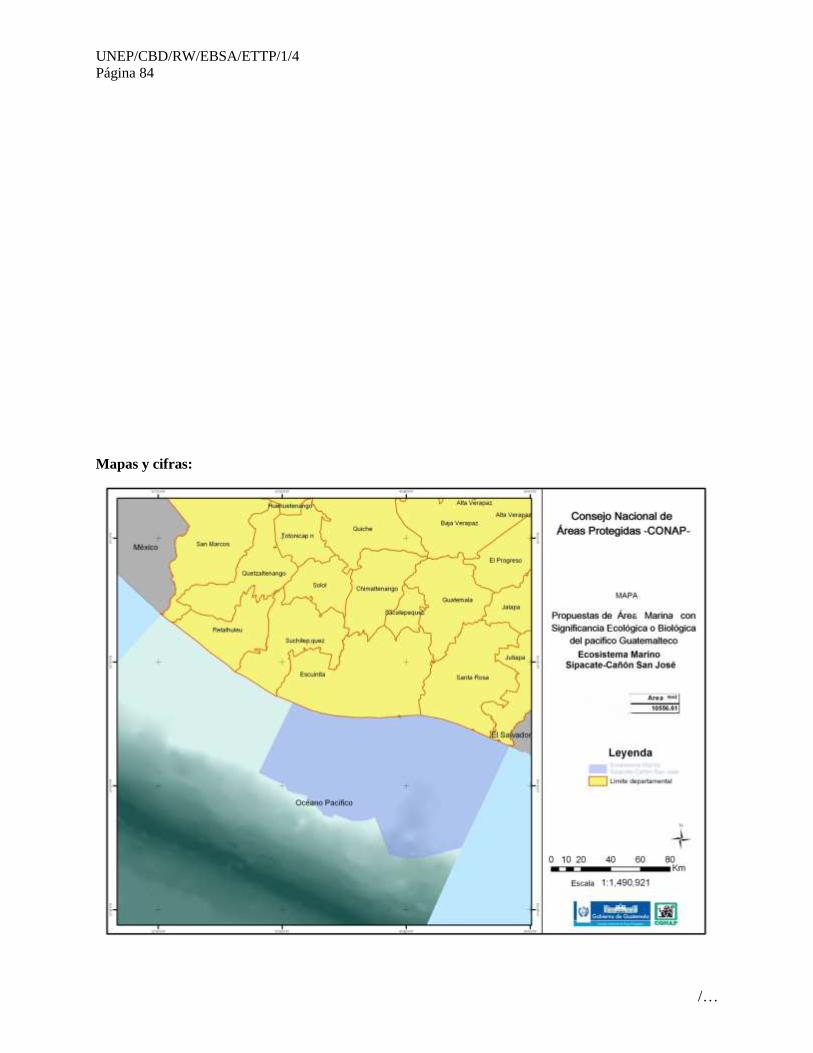
UNEP/CBD/RW/EBSA/ETTP/1/4
Página 84
/…
Mapas y cifras:

UNEP/CBD/RW/EBSA/ETTP/1/4
Página 85
/…
Figura 1. Mapa de sitios prioritarios para conservación en la Costa Sur de Guatemala.
(PROBIOMA 2008)
Figura 2 Ubicación de la Reserva Natural de Usos Múltiples Moterrico. Fuente: Quintana 2007.
Sitios importantes para Aves Acuáticas
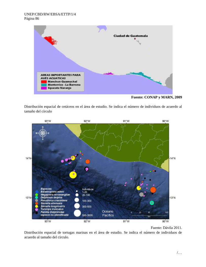
UNEP/CBD/RW/EBSA/ETTP/1/4
Página 86
/…
Fuente: CONAP y MARN, 2009
Distribución espacial de cetáceos en el área de estudio. Se indica el número de individuos de acuerdo al
tamaño del círculo
Fuente: Dávila 2011.
Distribución espacial de tortugas marinas en el área de estudio. Se indica el número de individuos de
acuerdo al tamaño del círculo.
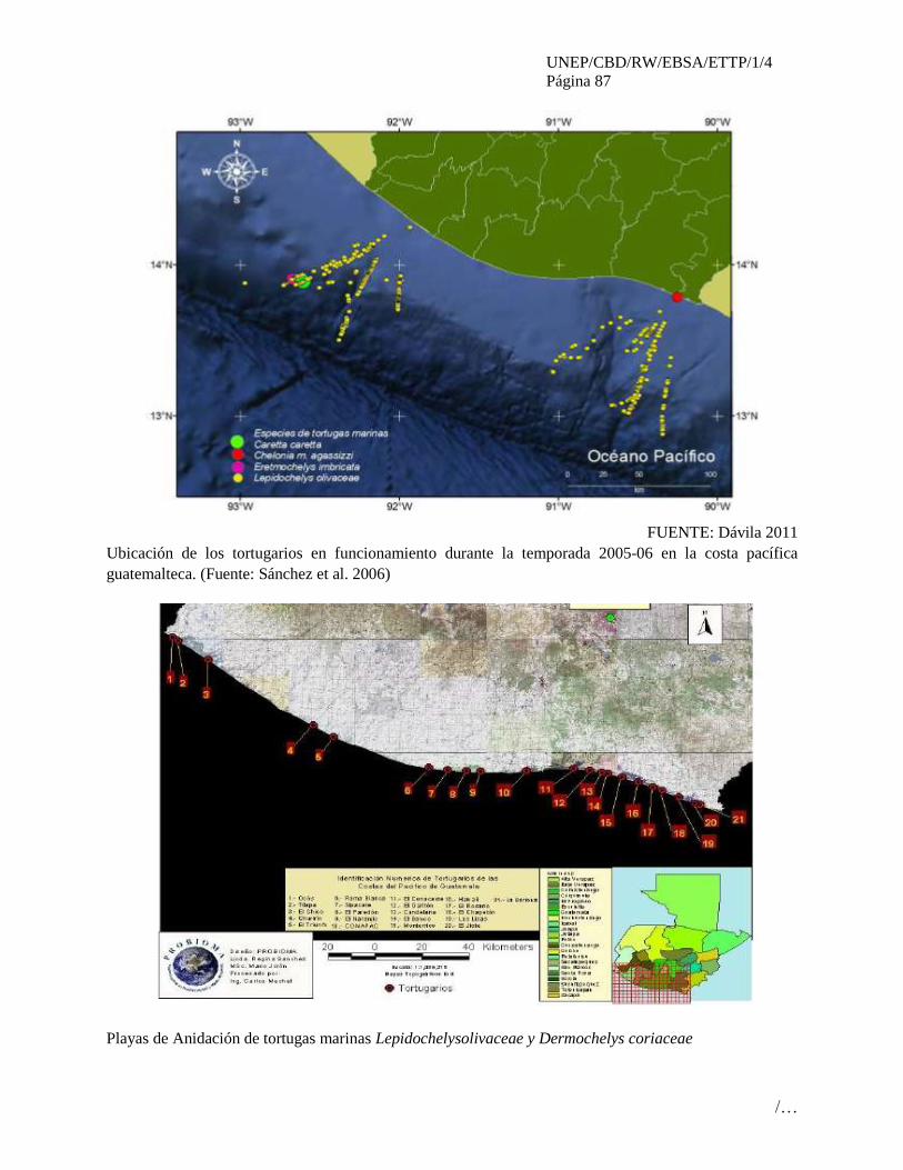
UNEP/CBD/RW/EBSA/ETTP/1/4
Página 87
/…
FUENTE: Dávila 2011
Ubicación de los tortugarios en funcionamiento durante la temporada 2005-06 en la costa pacífica
guatemalteca. (Fuente: Sánchez et al. 2006)
Playas de Anidación de tortugas marinas Lepidochelysolivaceae y Dermochelys coriaceae

UNEP/CBD/RW/EBSA/ETTP/1/4
Página 88
/…
Fuente: CONAP y MARN 2009
Distribución espacial de rayas y tiburones en el área de estudio. Se indica el número de individuos de
acuerdo al tamaño del círculo
FUENTE: Dávila 2011
Distribución espacial de peces picudos en el área de estudio. Se indica el número de individuos de
acuerdo al tamaño del círculo.
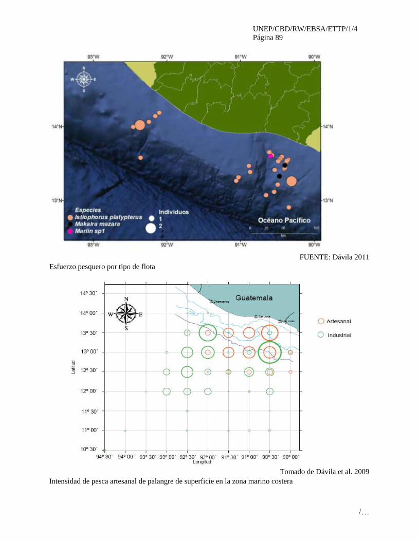
UNEP/CBD/RW/EBSA/ETTP/1/4
Página 89
/…
FUENTE: Dávila 2011
Esfuerzo pesquero por tipo de flota
Tomado de Dávila et al. 2009
Intensidad de pesca artesanal de palangre de superficie en la zona marino costera
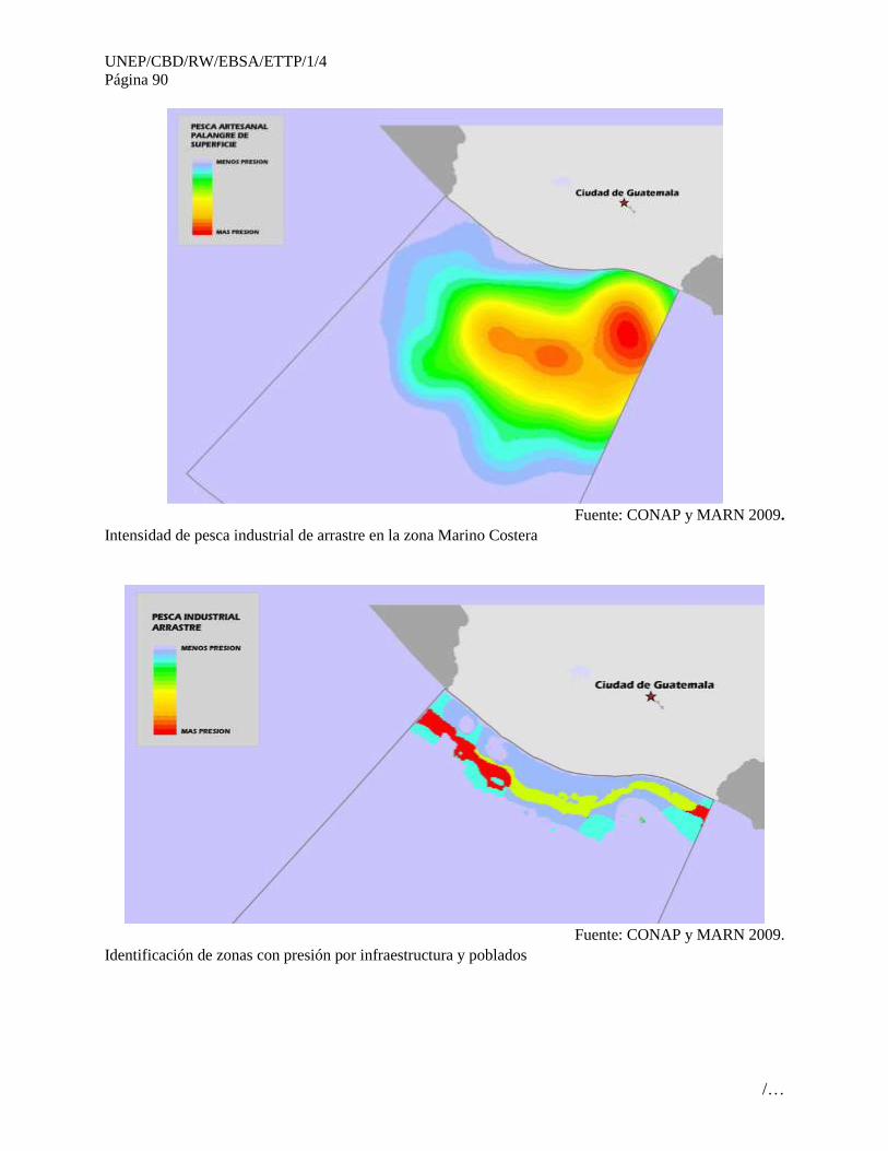
UNEP/CBD/RW/EBSA/ETTP/1/4
Página 90
/…
Fuente: CONAP y MARN 2009.
Intensidad de pesca industrial de arrastre en la zona Marino Costera
Fuente: CONAP y MARN 2009.
Identificación de zonas con presión por infraestructura y poblados

UNEP/CBD/RW/EBSA/ETTP/1/4
Página 91
/…
Fuente: CONAP y MARN 2009.

UNEP/CBD/RW/EBSA/ETTP/1/4
Página 92
/…
ÁREA NO. 5: GOLFO DE FONSECA
(GULF OF FONSECA)
Resumen
El golfo de Fonseca abarca aproximadamente 2015 km2 de superficie acuática asociada al Océano
Pacífico en Centroamérica. Tres países colindan: El Salvador, Honduras y Nicaragua. Varios ríos
confluyentes aportan nutrientes, contaminantes y sedimentos a este cuerpo de agua. Diferentes
ecosistemas componen el golfo, dentro de los principales se encuentran: manglares del golfo de Fonseca,
bosque tropical seco, bajos intermareales, zonas rocosas intermareales y submareales, entre otros.
También existen varias islas, algunas de ellas de considerable altura sobre el nivel del mar (>500 m). Es
una zona importante para la pesca y marisqueo artesanal, otras actividades que se desarrollas son:
salineras, acuacultura de camarón.
Introducción
El golfo de Fonseca representa una penetración del Océano Pacífico dentro del territorio centroamericano.
Confluyen varios ríos que aportan nutrientes, sedimentos, lo que convierte al golfo en un cuerpo de agua
con presencia de sedimentos suspendidos en el agua, cuya concentración varía según corrientes, lluvias,
mareas. Los manglares del área son únicos, en el sentido que debido a menores valores de precipitación
pluvial, mayor salinización del substrato, radiación solar, los árboles alcanzan alturas menores que otras
zonas de Centroamérica. Se caracteriza por la presencia de islas, con vegetación típica del bosque seco
tropical, manglares, bajos intermareales (playones), barras arenosas, zonas rocosas intermareales y
submareales. Existe un sitio Ramsar en territorio hondureño.
Presenta un comportamiento de estuario inverso durante la época seca (agua salada penetra en capas
superiores de la columna de agua y el agua dulce circula por la parte inferior. También, las corrientes
están dominadas por la marea, vientos y condiciones meteorológicas. La amplitud de mareas alcanza 3.5
m aproximadamente durante los períodos máximos. La profundidad máxima alcanza entre 25 a 30 metros.
Ubicación
Fig. 1. Mapa del golfo de Fonseca.
Descripción de las características del área propuesta
El golfo de Fonseca se caracteriza por la presencia de diferentes tipos de fondos a diferentes
profundidades: arenosos, sedimentos finos, mixtos, cantos rodados, rocosos. Los últimos caracterizados
por peñascos, rocas intermareales y submareales detectados hasta 12 metros de profundidad. Las islas
ubicadas en la parte sur presentan pendientes entre moderadas a intensas en la mayoría de su perímetro.
Al área se asocian dos estuarios importantes donde anida en gran cantidad la tortuga carey: Bahía de
Jiquilisco (El Salvador) y Estero Padre Ramos (Nicaragua). La profundidad maxima alcanza los 400
metros, considerando la gran cantidad de material flotante que se encuentra a esa profundidad. Existen
diferentes tipos de hábitats que permiten la existencia de una gran variedad de especies, algunos de
importancia comercial, adaptados a condiciones específicas como se señala en la siguiente tabla:
TIPO DE HABITAT ESPECIE(S)
Bajos (playones) intermareales Anadara grandis, Ocypode occidentalis,
Protothaca asperrima, Chione subrugosa,
Mytella sp., Penaeus spp., aves playeras.
Fondos lodosos intermareales Anadara tuberculosa, Anadara similis, Ocypode

UNEP/CBD/RW/EBSA/ETTP/1/4
Página 93
/…
occidentalis, Protothaca asperrima, Crassostrea
palmula, Chione subrugosa, Penaeus spp., aves
playeras.
Fondos bentónicos submareales, incluyendo
raíces de manglares y otras estructuras naturales o
artificiales.
Lutjanidae, Haemulidae, Ariidae, Sciaenidae,
Centrompomidae, Serranidae, Penaeus spp.,
Palaemonidae, Spondylus calcifer.
Pelágico Centropomidae, Carángidae, Clupeidae,
Eretmochelys imbricata, Chelonya mydas
agassizzi, Lepydochelys olivacea, Tursiops
truncatus.
Playas arenosas Eretmochelys imbricata, Lepidochelys olivacea,
particularmente circulación, forrajeo, con algunas
playas arenosas para anidación.
Islas Aves migratorias como Fregata magnifiscens
Muchos locales se dedican a la extracción de bivalvos, así como cangrejos. También pescadores utilizan
diferentes métodos para capturar peces. Como se mencionó anteriormente, el golfo se comporta como
estuario inverso durante la época seca y presenta corrientes importantes según la marea, eventos
meteorológicos extremos, vientos. También existe un estudio oceanográfico que se cita en las referencias.
Los manglares asociados funcionan como una zona de amortiguamiento de inundaciones y tormentas
tropicales. Las actividades de turismo están asociadas a la navegación. Actividades de buceo y snorkeling
son escasas debido a la turbidez del agua.
Condición de las características y perspectivas a futuro de la zona propuesta
Debido a la gran extensión del golfo, así como la colindancia de 3 países, un enfoque de uso sostenible
homogéneo está aún en proceso. Diversos proyectos internacionales han procurado un enfoque común al
desarrollo sostenible del área, pero existen limitaciones administrativas, logísticas que deben superarse.
Existen áreas naturales protegidas terrestres y estuarionas asociadas al golfo de Fonseca. Se han realizado
algunas investigaciones de índole oceanográfico, monitoreo de contaminantes, biodiversidad.
Evaluación del área sobre los criterios EBSA del CDB
Criterios
CBD EBSA
(Anexo I de la
decisión IX/20)
Descripción
(Anexo I de la decisión IX/20) Clasificación de los criterios
pertinentes
No lo se Bajo Alguno Alto
Características
únicas, rarezas
Área de singularidad o rareza contiene ya sea
(i) exclusivas («la única de su clase"), raras
(sólo ocurre en pocos lugares) o de especies
endémicas, poblaciones o comunidades, y / o
(ii) único, raro o distinto, los hábitats o los
ecosistemas, y / o (iii) características
geomorfológicos u oceanográficos exclusivos
o desacostumbrados.
X
Explicación para la clasificación
Extensión de manglar único por su peculiaridad (manglares del golfo de Fonseca, NT 1412), asóciada al
régimen de lluvias, evaporación y salinidad del golfo que crea condiciones especiales, abarcando 1554 km2
entre El Salvador a Nicaragua.

UNEP/CBD/RW/EBSA/ETTP/1/4
Página 94
/…
Importante zona de migración, alimentación de Eretmochelys imbricata (tortuga carey) del Pacífico
Oriental.
Zona importante de circulación de ballena jorobada (Megaptera novaengliae).
En el golfo de Fonseca se han recolectado y descrito dos nuevas especies para la ciencia (Notarius biffi,
Akko rossi, 2003-2004). De igual forma 4 especies de poliquetos fueron descritas: Eunice chicasi, Eunice
salvadorensis, Kinbergonuphis kristiani, Paradiopatra barrazai. También nuevo bivalvo (Periploma
kaiserae). Muchos invertebrados de la región panámica, solamente se encuentran en el golfo de Fonseca en
esa área del Pacífico tropical este: Zoántidos, Phyllangia sp., Oulangia sp., Mytella sp., Arbacia incisa,
Agassizia scrobiculata, Nidorellia armata. Un grupo importante que solamente ocurre en el golfo de
Fonseca en territorio salvadoreño son los cangrejos apretadores (stone crabs, Xanthidae: Menippe frontalis,
y al menos otra especie). También se ha detectado la presencia de Epinephelus itajara (mero.
Se agrega que el golfo de Fonseca aporta gran cantidad de material flotante al Océano Pacífico que presenta
alguna implicación en circulación de peces pelágicos (Greenblat, 1979) y para el fondo (400 m-1000 m?,
CRUCERO MIGUEL OLIVER 2009), donde existe la posiblidad de existencia de hábitats únicos asociados
al aporte del material flotante.
También incluye un sitio Ramsar en el área de Honduras (Sistema de humedales de la zona sur de Honduras,
No. 1000), así como otro en territorio salvadoreño (Complejo Bahía de Jiquilisco, No. 1586).
Parte de la rareza incluye islas de origen volcánico, que puede presentar actividad termal submarina, no se
ha investigado.
Importancia
especial para
las etapas del
ciclo biológico
de especies
Las áreas requieren una población para
sobrevivir y prosperar.
X
Explicación para la clasificación
Sitio de circulación de alimentación de tortuga carey (Eretmochelys imbricata). Anidación de otras tortugas:
L. olivacea, Chelonia mydas agassizzi. El descubrimiento de anidación y cierculación de carey es reciente y
dada la escasez de sitios de anidación de tortugas carey en el Pacífico este, hay proyectos internacionales
apoyando la reproducción protegida y estudios sobre esta tortuga. Una de las iniciativas que ha generado es
ICAPO (Iniciativa del Carey del Pacífico Oriental, www.hawksbill.org). Esta iniciativa cuenta con
colaboración de USAID, USNOAA, National Fish and Wildlife Foundation, People’s Trust for Endagered
Species, US Fish and Wildlife, International Seafood Sustainabilit Foundation.
En islas Conchagüita, Meanguera, Piritallo, existe una colonia importante de Fregata magnifiscens que
utiliza las islas como zonas de preparación para apareamiento.
Existe una de las colonias mas importantes de Sterna anaethetus (1200 adultos y 9 polluelos, Komar, 1994).
en isla Farallones. Otras colonias importantes existen en México y Costa Rica.
Importancia de
especies
amenazadas, en
peligro o en
declive y/o
hábitats
Áreas que contienen hábitat para la
supervivencia y recuperación de especies en
peligro, amenazadas, especies en declive o
área con agrupamientos significativos de tales
especies.
X
Explicación para la clasificación
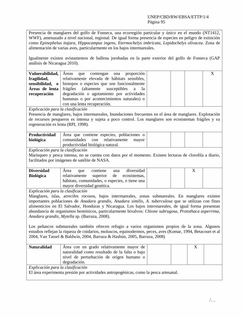
UNEP/CBD/RW/EBSA/ETTP/1/4
Página 95
/…
Presencia de manglares del golfo de Fonseca, una ecorregión particular y único en el mundo (NT1412,
WWF), amenazado a nivel nacional, regional. De igual forma presencia de especies en peligro de extinción
como Epinephelus itajara, Hippocampus ingens, Etermochelys imbricata, Lepidochelys olivacea. Zona de
alimentación de varias aves, particularmente en los bajos intermareales.
Igualmente existen avistamentos de ballena jorobadas en la parte exterior del golfo de Fonseca (GAP
análisis de Nicaragua 2010).
Vulnerabilidad,
fragilidad,
sensibilidad, o
Áreas de lenta
recuperación
Áreas que contengan una proporción
relativamente elevada de hábitats sensibles,
biotopos o especies que son funcionalmente
frágiles (altamente susceptibles a la
degradación o agotamiento por actividades
humanas o por acontecimientos naturales) o
con una lenta recuperación.
X
Explicación para la clasificación
Presencia de manglares, bajos intermareales, Inundaciones frecuentes en el área de manglares. Explotación
de recursos pesqueros es intensa y sujeta a poco control. Los manglares son ecosistemas frágiles y su
regeneración es lenta (RPI, 1998).
Productividad
biológica
Área que contiene especies, poblaciones o
comunidades con relativamente mayor
productividad biológica natural.
Explicación para la clasificación
Marisqueo y pesca intensa, no se cuenta con datos por el momento. Existen lecturas de clorofila a diario,
facilitados por imágenes de satélite de NASA.
Diversidad
Biológica
Área que contiene una diversidad
relativamente superior de ecosistemas,
hábitats, comunidades, o especies, o tiene una
mayor diversidad genética.
X
Explicación para la clasificación
Manglares, islas, arrecifes rocosos, bajos intermareales, zonas submareales. En manglares existen
importantes poblaciones de Anadara grandis, Anadara similis, A. tuberculosa que se utilizan con fines
alimenticios en El Salvador, Honduras y Nicaragua. Los bajos intermareales, de igual forma presentan
abundancia de organismos bentónicos, particularmente bivalvos: Chione subrugosa, Protothaca asperrima,
Anadara grandis, Mytella sp. (Barraza, 2008).
Los peñascos submareales también ofrecen refugio a varios organismos propios de la zona. Algunos
estudios reflejan la riqueza de cnidarios, moluscos, equinodermos, peces, aves (Komar, 1994, Betacourt et al
2004, Van Tassel & Baldwin, 2004, Barraza & Hasbún, 2005, Barraza, 2008)
Naturalidad Área con un grado relativamente mayor de
naturalidad como resultado de la falta o bajo
nivel de perturbación de origen humano o
degradación.
X
Explicación para la clasificación
El área experimenta presión por actividades antropogénicas, como la pesca artesanal.
UNEP/CBD/RW/EBSA/ETTP/1/4
Página 96
/…
Referencias
Barraza, J.E. & C. R. Hasbún. 2005. Los equinodermos (Echinodermata) de El Salvador. Revista
de Biología Tropical. Vol. 53 (Suppl. 3): 139-146.
Barraza, 2008. Revisión sobre algunos taxa de macroinvertebrados acuáticos en El Salvador.
Ministerio de Medio Ambiente y Recursos Naturales. San Salvador, El Salvador.
www.marn.gob.sv/index.php?option=com_content&view=article&id=128&Itemid=183
Barraza, J.E. 2011. Areas marinas protegidas en El Salvador: un arrecife rocoso y un estuario.
Revista Parques, FAO. http://revistaparques.org/pdf/art31.pdf
Betancur-R., R. & A. Acero P. 2004. Description of Notarias biffi n. sp. and redescription of N.
insculptus (Jordan and Gilbert) (Siluriformes: Ariidae) from the eastern Pacific, with evidence of
monophyly and limits of Notarius. Zootaxa, 703: 1-20.
De León-González, J.A., C. G. Rivera, & M. Y. Romero. 2004. Sublittoral Eunicidae and
Onuphidae (Polychaeta) from soft bottoms off El Salvador, Eastern Pacific. Journal of the Marine
Biological Association of the United Kingdom. Vol 84: 93-101.
Komar, O. & W. Rodriquez. A major bridled stern Sterna anaethetus colony in the Gulf
of Fonseca, Nicaragua Colonial Water Birds 19 (2): 264-267
Liles, M, et. Al. 2011 Hawksbill turtles Eretmochelys imbricata in El Salvador nesting
distribution and mortality at the largest remaining nesting distribution and mortality at the
largest remaining nesting aggregation in the Eastern Pacific Ocean. Endag. Spec. Res. 14:
23-30.
Plotkin, P. M. 2010. Nomadic behaviour of the highly migratory olive ridley sea turtle
Lepidochelys oliveacea in the eastern tropical Pacific Ocean. End. Spec. Res. 13: 33-40.
Research Planning Inc. 1998. Levantamiento y mapeo de indices de sensibilidad
ambiental de la línea costero-marina entre las desembocaduras de los ríos Paz y Lempa.
Vol I. Fondo Inciativa de las Américas de El Salvador. C.G. Rivera, T. C. Cuéllar. 2010.
Biodiversidad de Bahía de Jiquilisco. Universidad de El Salvador. 231 pp.
Valle-Levinson, A. & K. T. Bosley. 2003. Reversing circulation patterns in a tropical
estuary. J. Geophysiscs Research, 108 (C10), 3331, doi: 10.1029/2003JC0011786, 2003.
Van Tassel, J. L. & C. C. Baldwin. 2004. A review of the gobiid genus Akko (Teleostei:
Gobiidae) with desrciption of a new species. Zootaxa, 462: 1-15.
The Naturel Consevancy, 2010. Biodiversidad marino costera de Nicaragua. 168 pp.
TORTUGA CAREY
www.iacseaturtle.org
www.hawksbill.org
http://www.bio.sdsu.edu/Pub/lewison/conservation/pmwiki.php?n=Main.AlexanderGaos
Gaos et al. 2012_Hawksbill dive behaviour
Gaos et al. 2012_Hawksbill spatial ecology
Quinones et al. 2011_Southern observations of hawksbill in Peru
Gaos et al. 2011_Hawksbill life-history paradigm shift
Miranda et al. 2011_Maculis (El Salvador) Characterization Report
Liles et al. 2011_Hawksbill turtles in El Salvador
Alfaro-Shigueto et al. 2010_Ei in Peruvian coastal fisheries

UNEP/CBD/RW/EBSA/ETTP/1/4
Página 97
/…
Altamirano et al. 2010_(Spa) Estero Padre Ramos hawksbill project technical report
Yañez et al. 2010_Second hawksbill workshop proceedings
Gaos & Urteaga 2010_Hawksbills in Estero Padre Ramos, Nicaragua
Gaos et al 2010_Hawksbill turtles in the EP
Carrion 2010_Hawksbill diet, foraging and habitat in Costa Rica
Trujillo 2009_Hawksbill Genetics for Pacific Colombia
ICAPO 2008_First hawksbill workshop proceedings
Gaos et al. 2006_Hawksbills Pacific Costa Rica
Seminoff et al. 2003_Hawksbills in Baja
Seminoff et al. 2003_hawksbill/green hybrid
Nichols 2003_Baja Sea Turtles Dissertation
NMFS/USFWS 1998_Pacific Hawksbill Recovery Plan
Hasbún et al. 1998_Unusual record of a hawksbill
www.worldwildlife.org/ecoregions/nt1412

UNEP/CBD/RW/EBSA/ETTP/1/4
Página 98
/…
Mapas y cifras
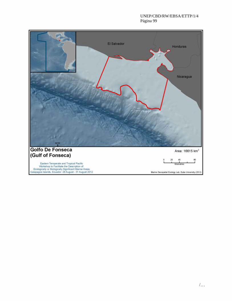
UNEP/CBD/RW/EBSA/ETTP/1/4
Página 99
/…

UNEP/CBD/RW/EBSA/ETTP/1/4
Página 100
/…
ÁREA NO. 6: DORSAL SUBMARINA DE MALPELO
(MALPELO RIDGE)
Resumen
La dorsal submarina de Malpelo se encuentra en la zona central de la cuenca del Océano Pacífico
colombiano y se extiende en dirección noreste-suroeste con una longitud de 240 km, un ancho de 80 km y
se levanta rápidamente desde unos 4000 m de profundidad por el costado oriental. Esta área proporciona
el hábitat que da lugar a la presencia de endemismos y al asentamiento a una alta riqueza en
biodiversidad, así como la presencia de diferentes especies de mamíferos marinos y tiburones que
cumplen parte de su ciclo de vida en esta área. El estado natural de estas áreas permite describirlas como
áreas que satisfacen los criterios EBSA, importantes para la región del Pacifico tropical oriental, no
obstante la presencia de sobreexplotación de recursos pesqueros y el efecto de ENSO pueden hacerla más
vulnerable.
Introducción
La dorsal submarina de Malpelo se encuentra en la zona central de la cuenca del Océano Pacífico
colombiano y se extiende en dirección noreste-suroeste con una longitud de 240 km, un ancho de 80 km y
se levanta rápidamente desde unos 4000 m de profundidad por el costado oriental (Lonsdale y Klitgord,
1978), en donde predomina la isobata de 2000 m, y donde se encuentra el bajo Bojacá a una profundidad
de 281 m. Su origen es de una interacción ocurrida hace más de 20 millones de años entre el “hot spot” de
Galápagos y el centro de acreción Coco-Nazca, interacción que generó una alta actividad volcánica que
originó la isla Malpelo (Sallarés et al., 2003). En el área presenta un comportamiento estacional semestral
determinado por el movimiento de la Zona de Convergencia Inter Tropical (ZCIT) (Devis-Morales et al.,
2008). Durante el segundo semestre del año, los vientos del sureste dominan toda la cuenca del Océano
Pacífico colombiano ubicando a la ZCIT en su posición más septentrional (8-10° N) y permitiendo que
predomine un patrón de circulación de aguas superficiales ciclónico en sentido contrario a las manecillas
del reloj (Devis-Morales et al., 2008). Durante el fin e inicio de año, la ZCIT se ubica en su posición más
meridional debido a la predominancia de los vientos alisios del norte, que empujan la ZCIT hacia el sur
por medio del proceso físico denominado chorro de viento de Panamá (Rodríguez-Rubio et al., 2003).
Durante este período, la mayor parte del agua que sale del golfo de Panamá, donde ocurre un fuerte
afloramiento y un estrechamiento de la termoclina, se desvía al oeste y se une a una circulación
anticiclónica (a favor de las manecillas del reloj). La porción emergida de la dorsal se llama isla Malpelo
la cual ocupa 1.2 km2 (López-Victoria y Rozo, 2006) y en 1995 fue declarado Santuario de Fauna Flora,
posteriormente en el 2002 fue declarada la Organización Marítima Internacional (OMI) como una Zona
Marítima Especialmente Sensible, re-alinderando el SFF a un polígono de forma cuadrada que contiene
totalmente un circulo con un radio de 25 millas náuticas con centro la isla Malpelo. Actualmente SFF
Malpelo es considerado como un Área de Importancia de Conservación de (AICAS), así mismo, desde el
año 2006 un sitio Patrimonio de la Humanidad y constituye, junto con las islas Galápagos (Ecuador), de
Coco (Costa Rica), de Coiba (Panamá) y Gorgona (Colombia) el Corredor Marino de Conservación del
Pacífico Este Tropical (CMAR).
La dorsal contiene un mosaico de ecosistemas marinos profundos, submareales, litorales y terrestres
únicos que albergan especies terrestres y marinas endémicas, además de promover el desarrollo de una
amplia variedad de vida marina. La anterior morfología proporciona el hábitat que da lugar al
asentamiento a una alta riqueza en biodiversidad como la existencia de los pocos fondos con cobertura
coralina viva del POT, la colonia de aves marinas más grande de Colombia, la presencia de tiburones
martillo (Sphyrna lewini) y areas reproductivas de esta especie (Bessudo et al., 2012), mamíferos marinos
(13 especies) en donde se destaca la presencia de areas de agregación reproductiva de ballena jorobada
(Megaptera novaeangliae) (Palacios et al., 2012); una variedad de especies endémicas de peces,
crustáceos, reptiles, entre otros). Así mismo existen 30 especies de diferentes grupos en categoría de
amenaza en libros rojos y dentro del Convenio Internacional CITES.

UNEP/CBD/RW/EBSA/ETTP/1/4
Página 101
/…
Esta Área presenta una buena cobertura de información en la porción emergida (isla Malpelo) tanto
batimétrica como biológica. No obstante, a pesar de que a partir de la década de los 90s ha aumentado el
número de publicaciones científicas y cruceros de investigación en los ambientes más profundos es
necesario aunar esfuerzos a nivel regional para entender las dinámicas de la estructura, estabilidad y
resiliencia de las comunidades marinas que se desarrollan en este tipo de ambientes y su estrecha relación
con la variabilidad propia del entorno en el marco del PTO y al estrategia de conservación del CMAR.
Ubicación
El área de estudio está comprendida entre los 1º 29‘24''N - 5º 0‘02''N y 79º 40‘26''W y 82º 44‘56''W, la
cual se encuentra enteramente dentro de la jurisdicción nacional en la cuenca oceánica de Pacifico
colombiano.
Descripción de las características del área propuesta
La cordillera Malpelo es una elevación larga y angosta con flancos escarpados que limita con la cuenca
del Pacífico al oriente y con la zona de fractura de Panamá al occidente; este rasgo se ubica en la región
central del Pacífico colombiano y se extiende por aproximadamente 400 km en dirección NE-SW con una
amplitud de 218 km en la parte más proximal al continente; esta cordillera es considerada asísmica y en
ella se destacan los montes submarinos de Malpelo y Bojacá, además de una pared escarpada denominada
el escarpe Tolima, y otras geoformas características como colinas y lomas, depresiones, terrazas y
mesetas, valles submarinos y espolones (IDEAM et al., 2007). En este sector, la isla oceánica de Malpelo
se levanta abruptamente desde los fondos abisales a más de -4000 m de profundidad formando un
promontorio rocoso de pocas dimensiones que se eleva 360 m.s.n.m.; no cuenta con una plataforma
insular y sus fondos son de naturaleza rocosa y muy inclinada, con mínima sedimentación (IDEAM et al.,
2007). De acuerdo con la información registrada por ChEssbase (2010) existen “cold sepes” con un
probabilidad alta de especies endémicas asociados a estos ambientes quimio-sintéticos.
The surrounding waters of this area support massive populations of pelagic bony fishes, sharks, marine
mammals and sea turtles (Brando et al, 1992). One of the most outstanding features of Malpelo is that is
one of the few places in the world to record confirmed sightings of the short-nosed ragged–toothed shark
(Odontaspis ferox) (Bessudo and Caballero, in press), a deepwater shark known locally as “the monster”.
Additionally, great aggregations of pelagic species, including outstanding schools of over 200 individuals
of hammerhead sharks (Sphyrna lewini), over 1000 inidividuls of silky sharks (Carcharhinus falciformis)
(Bessudo et al., 2012), whale sharks (Rhincodon typus) and tuna (Thunnus spp.) have been recorded
around the area. There are also barracuda Sphyraena idiastes, eagle and manta rays Aetobatus narinari
(EN) and Manta birostris, with great numbers of striped bonito Sarda orientalis, snappers Lutjanus sp.
and travelly Caranx spp. There are the Pacific seahorse (VU) and two endemic sea stars Tamaria stria
and Narcissia gracilis malpeloensis. Many more marine species probably remain to be described,
especially among the invertebrates.
The Malpelo masked boobies (Sula granti) breeding colony is the largest in the world with over 40.000
individuals, followed by the Galapagos colonies with over 20.000 individuals; the rest of the colonies in
the ETP are significantly smaller (Pitman &Jehl, 1998; Calidris 2004). The masked boobies (Sula granti)
breeding colonies can only be found worldwide in the ETP (Pitman & Jehl, 1998). Furthermore, the
ecology of the island is based on the guano of these birds, which provides nutrients to the food chain
(Brando et al, 1992).
Esta área tiene una gran diversidad en algunos grupos de especies (1088 especies) como: peces (394),
corales duros (24), equinodermos (11), poliquetos (>40), moluscos (340), crustáceos (158), esponjas
(>10), aves (65), mamíferos marinos (17), reptiles marinos (6) y macrolagas (>20).

UNEP/CBD/RW/EBSA/ETTP/1/4
Página 102
/…
Condición de las características y perspectivas a futuro de la zona propuesta
Currently, the area is a globally significant and largely “pristine” marine area with unaltered and non-
threatened ecosystems that is essential to maintain and replenish the population of sharks, giant grouper
and billfish in the Eastern Tropical Pacific, whilst providing unique opportunities for ecosystem
conservation, research, and recreational diving.
In 2004, over 80 hammerhead sharks (Sphyrna lewini) and silkies (Carcharhinus falciformis) were found
dead in several drift nets tangled between the rocks of Malpelo Island. Many other fishes and crustaceans
also died as a result of these discharged nets. Unfortunately, this event has been reported several times in
different parts of Malpelo over the past years (Bessudo et al., 2011)
La presencia de la especie de coral blando invasora Carijoa riisei reportada y enfermedades fungicas
reportadas recientemente pueden ser atribuidas a las anomalías térmicas que se han presentando como
consecuencias del ENSO en la cuenca de Pacífico en los últimos años (Sanchez et. al., 2012).
Evaluación del área sobre los criterios EBSA del CDB
Criterios
CBD EBSA
(Anexo I de la
decisión IX/20)
Descripción
(Anexo I de la decisión IX/20) Clasificación de los criterios
pertinentes
No lo se Bajo Alguno Alto
Características
únicas, rarezas
Área de singularidad o rareza contiene ya sea
(i) exclusivas («la única de su clase"), raras
(sólo ocurre en pocos lugares) o de especies
endémicas, poblaciones o comunidades, y / o
(ii) único, raro o distinto, los hábitats o los
ecosistemas, y / o (iii) características
geomorfológicos u oceanográficos exclusivos
o desacostumbrados.
X
Explicación para la clasificación
Esta área presenta una geoforma particular por presentar una pared escarpada (escarpe del Tolima) que se
levanta 4.000 m abruptamente desde los fondos abisales con algunos montes submarinos (IDEAM et al.,
2007), dándole una característica particular a las comunidades asociadas a este paisaje marino.
Se presentan endemismos (% local) en algunos grupos biológicos como: tres especies de reptiles terrestres
(100%) (Anolis agassizi, Diploglossus millepunctatus y Phyllodactylus transversales) (Rand et al., 1975;
Kiester, 1975; Huey, 1975; López-Victoria, 2006), cinco especies de peces (1,7%) (Halichoeres malpelo,
Axoclinus rubinoffi, Lepidonectes bimaculatus, Chriolepis lepidotus, y Acanthemblemaria stephensi
(Robertson & Allen, 2008), dos especies de equinodermos (10%) (Tamaria stria y Narcissia gracilis
malpeloensis) y una especie de crustáceos (1%) (Gecarcinus malpilensis).
One of the most outstanding features of Malpelo is that is one of the few places in the world to record
confirmed sightings of the short-nosed ragged–toothed shark (Odontaspis ferox) (Bessudo and Caballero,
in press).
Importancia
especial para
las etapas del
ciclo biológico
de especies
Las áreas requieren una población para
sobrevivir y prosperar.
X
Explicación para la clasificación

UNEP/CBD/RW/EBSA/ETTP/1/4
Página 103
/…
La presencia de crías junto con su madre de ballena jorobada (Megaptera novaeangliae) sugiere que el
uso que están haciendo de Malpelo es de carácter reproductivo con tasa de encuentro de 1.62 grupos/100
h) (Herrera-Carmona, et al., 2012; Palacios et al., 2012); es probable que su presencia en Malpelo
corresponda a una estadía temporal de grupos en tránsito hacia o desde las áreas de concentración costeras
en Colombia (Flórez-González, 1991; Flórez-González et al., 1998), Ecuador (Félix y Haase, 2005),
Panamá y/o Costa Rica (Rasmussen et al., 2002).
Grandes agregaciones de tiburón martillo han sido documentados en el área durante primer trimestre del
año en época de aguas frías definiendo una posible área de reproducción de tiburón martillo (Hazin et al.,
2001; Bessudo et al., 2012), seguido del período (abril-mayo) con una reducción de sus densidades
posiblemente por sus largas migraciones (Sibajo-Cordero, 2008; Bessudo et al., 2011).
Así mismo, se presentan sitos de agregación de aves marinas (65 sp): 43% ocasionales, 42% accidentales
y 15% residentes (Zamudio, 2012; López-Victoria y Estela, 2007) .
The Malpelo masked boobies (Sula granti) breeding colony is the largest in the world with over 40.000
individuals, followed by the Galapagos colonies with over 20.000 individuals; the rest of the colonies in
the ETP are significantly smaller (Pitman and Jehl, 1998; Calidris, 2004; Lopez-Victoria y Estela , 2007)
Importancia de
especies
amenazadas, en
peligro o en
declive y/o
hábitats
Áreas que contienen hábitat para la
supervivencia y recuperación de especies en
peligro, amenazadas, especies en declive o
área con agrupamientos significativos de tales
especies.
X
Explicación para la clasificación
Se encuentran algunas especies en categorías de amenaza ed IUCN y libros rojos nacionales de grupos
principales de: (1) mamíferos marinos, como Megaptera novaeangliae (VU), Balaenoptera musculus
(EN), Delphinus delphis (EN), Stenella attenuata (LR), Physeter macrocephalus (VU), Zalophus
wollebaeki (VU), Arctocephalus galapagoensis (VU). (2) Aves, como Sula granti (VU), Creagrus
furcatus (EN), Pterodroma phaeopygia (CR). (3) marine reptiles, como Lepidochelis olivacea (EN),
Chelonia agassizii (EN), Eretmochelys imbricata (CR), Dermochelys coriacea (CR), Caretta caretta
(EN). (4) peces, como Epinephelus itajara (CR), Ginglymostoma cirratum (VU), Rhincodon typus (VU),
Hippocampus ingens (VU), Carcharhinus limbatus (VU). (IUCN, 2010)
Del grupo de los cnidarios 16 especies esta reportados en CITES como apéndice II, Antipathes
galapagensis, Antipathes gracilis, Pocillopora capitata, Pocillopora elegans, Pocillopora eydouxi,
Porites lobata, Pavona chiriquiensis, Pavona gigantean, Pavona varians, Pavona clavus, Pavona
maldivensis, Gardineroseris planulata, Cladocora pacifica, Tubastraea aurea, Tubastraea coccinea,
Cladopsammia eguchii (Reyes & Santodomingo, 2002).
Esta área presenta poblaciones de tiburón martillo (Sphyrna lewini) lo que lo hace importante al
reportarse en los últimas décadas declinaciones del 75% de esta especie a nivel mundial (IUCN, 2007;
Camhi et al., 2008)

UNEP/CBD/RW/EBSA/ETTP/1/4
Página 104
/…
Vulnerabilidad,
fragilidad,
sensibilidad, o
Áreas de lenta
recuperación
Áreas que contengan una proporción
relativamente elevada de hábitats sensibles,
biotopos o especies que son funcionalmente
frágiles (altamente susceptibles a la
degradación o agotamiento por actividades
humanas o por acontecimientos naturales) o
con una lenta recuperación.
X
Explicación para la clasificación
Durante los últimos cuatro años se ha reportado la presencia de la especie invasora de coral blando
Carijoa riisei la cual compite agresivamente por el espacio llegando a recubrir y desplazar otros
invertebrados (Kang et al., 2008)
Así mismo en el 2010 se reportan enfermedades fúngicas que pueden ser atribuidas a las anomalías
térmicas prolongadas que se han presentando en la cuenca de Pacífico en los últimos años (Sanchez et.
al., 2012).
Por otra parte, la sobre pesca de tiburones en el área reportado en los últimos años (Bessudo et al., 2011)
convierte esta área en un sitio con alta vulnerabilidad a la salud del ecosistema al eliminar de la cadena
trófica estos depredadores top.
Productividad
biológica
Área que contiene especies, poblaciones o
comunidades con relativamente mayor
productividad biológica natural.
X
Explicación para la clasificación
Durante el primer trimestre del año, el bombeo de Ekman resultante del efecto rotor del chorro de viento
de Panamá favorece el ingreso de agua subsuperficial a la zona fótica de la cuenca oceánica del Pacifico
colombiano (Rodríguez-Rubio y Stuardo, 2002). Esta agua, tiene un alto contenido de nutrientes, lo que
provoca un incremento en la productividad primaria local (valores de clorofila a de: revisar) de la
columna de agua (Pennington et al., 2006; Rodriguez-Rubio et al., 2007)
The presence of reducing environments “cold seeps” identified in this area (ChEssBase, 2010), exhibit a
high biological productivity and it is known that they host a high proportion of endemic species.
Diversidad
Biológica
Área que contiene una diversidad
relativamente superior de ecosistemas,
hábitats, comunidades, o especies, o tiene una
mayor diversidad genética.
X
Explicación para la clasificación
The presence of diverse submarine landscapes defined by the morphology, depth, types of bottom hard
and rough texture (niche complexity), constitutes the greater biological diversity in this area.
The surrounding waters of this oceanic island support massive populations of pelagic bony fishes, sharks,
marine mammals and sea turtles (Brando et al, 1992).
A total of 1088 species of fishes, echinoderms, mollusks, crustaceous, cnidarians and marine mammals
have been recorded, several of them first recorded in the Eastern Tropical Pacific -ETP (Birkeland , et al.,
1975; Brando et al., 1992; Allen and Robertson, 1998; INVEMAR, 2004)
Additionally, large aggregations of pelagic fishes and marine mammals are present in la dorsal de
Malpelo such as: great schools of hammerhead sharks (Sphyrna lewini), silky sharks (Carcharhinus
falciformis), amber jack (Seriola rivoliana), many species of tunas (Thunus sp.), snappers (Lutjanus sp.),
eagle rays (Aetobatus narinari) barracudas (Sphyraena idiastes), bottlenose dolphins (Tursiops

UNEP/CBD/RW/EBSA/ETTP/1/4
Página 105
/…
truncatus), as well as many others.
Naturalidad Área con un grado relativamente mayor de
naturalidad como resultado de la falta o bajo
nivel de perturbación de origen humano o
degradación.
X
Explicación para la clasificación
Currently, the area is a globally significant and largely “pristine” marine area with unaltered and non-
threatened ecosystems that is essential to maintain and replenish the population of sharks, giant grouper,
marine mammals, and billfish in the Eastern Tropical Pacific, whilst providing unique opportunities for
ecosystem conservation, research, and recreational diving.
Referencias
Allen, R.G and Robertson, D.R., 1998. Fishes of the Tropical Eastern Pacific. Crawford
House Press PTY Ltd. Publisher in the USA Hawai University Press. 327 p
Bessudo, S., G. Soler, A. P. Klimley, J. T. Ketchum, R. Arauz and A. Hearn. 2011.
Residency of the scalloped hammerhead shark (Sphyrna lewini) at Malpelo Island and
evidence of migration to other islands in the Eastern Tropical Pacific. Environ. Biol.
Fishes, 91 (2): 165-176.
Bessudo, S., G. Soler, A. P. Klimley, J. T. Ketchum, R S 2, Randall A., Hearn, A.,
Guzmán, A. B. Calmettes. 2012. Vertical and horizontal movements of the scalloped
hammerhead shark (sphyrna lewini) around malpelo and cocos islands (tropical eastern
pacific) using satellite telemetry. Bol. Invest. Mar. Cost. 40 (Supl. Esp.): 91-106
Birkeland, C., Meyer, D.L., Stames J.P and. Buford, C. L., 1975. Subtidal communities
of Malpelo island. In: The Biological Investigation of Malpelo island, Colombia. J.
Graham (Ed). Smithsonian Institution Press No. 176: 55-68
Brando, A, Prahl H.V. and. Cantera, J.R., 1992. Malpelo Isla Oceánica de Colombia.
Banco de Occidente. 195 p.
Calidris, 2004. Informe Final Proyecto”Monitoreo de aves acuáticas (marinas y playeras)
y su articulación como herramienta en la planificación, manejo y conservación de tres
áreas protegidas del Pacífico sur de Colombia”.
Camhi, M. D., E. Lauck, E. K. Pikitch and E. A Babcock. 2008. A global overview of
commercial
fisheries for Open Ocean sharks. 166-192. In: Camhi, M. D., E. K. Pikitch and E. A.
Babcock (Eds.). Sharks of the open ocean: Biology, fisheries and conservation. Blackwell
Publishing, Oxford. 536 p.
CDB. 2008. Convention on Biological Diversity, Synthesis and review of the best
available scientific studies on priority areas for biodiversity conservation in marine areas
beyond the limits of national jurisdiction. UNEP/CBD/SBSTTA/13 /INF/11. 52 p.
Devis-Morales, A., W. Schneider, R. A. Montoya-Sánchez y E. Rodríguez-Rubio. 2008.
Monsoon-like winds reverse oceanic circulation in the Panama Bight. Geophys. Res.
Lett., 35 L20607: 1-6.
ChEssBase. 200. http://www.noc.soton.ac.uk/chess/database/db_home.php
Félix, F. y B. Haase. 2005. Distribution of humpback whales along the coast of Ecuador
and management implications. J. Cetacean Res. Manage., 7 (1): 21-31.

UNEP/CBD/RW/EBSA/ETTP/1/4
Página 106
/…
Flórez-González, L. 1991. Humpback whales Megaptera novaeangliae in the Gorgona
Island, Colombian Pacific breeding waters: population and pod characteristics. Mem.
Queensland Mus., 30 (2): 291 295
Flórez-González, L., J. Capella, B. Haase, G. Bravo, F. Félix y T. Gerrodette. 1998.
Changes in winter destinations and northernmost record of Southeastern Pacific
humpback whales. Mar. Mammal Sci., 14 (1): 189-196
Freiwald, A., Fossa, J., Grehan, A., Koslow, T. & M. Roberts. 2004. Cold-Water coral
reefs: Out of sight, no longer out of mind. UNEP-WCMC, Cambridge, UK.
Hazin, F., A. Fisher and M. Broadhurst. 2001. Aspects of reproductive biology of the
scalloped
hammerhead shark, Sphyrna lewini, off Northeastern Brazil. Environ. Biol. Fishes, 61
(2): 151-159.
Herrera-Carmona, J., Capella, J., Soler, G., Bessudo, S., García, C. y L. Flórez-González.
2012. Ocurrencia y tasas de encuentro de mamíferos marinos en las aguas de la isla
Malpelo y hacia el continente. Bol. Invest. Mar. Cost. 40 (Supl. Esp.): 57-78
Huey, R. B. 1975. A new gecko from Malpelo Island (Sauria: Gekkonidae:
Phyllodactylus). Smithsonian Contr. Zool., 176: 44-46.
INVEMAR, 2004. Informe del estado de los ambientes marinos y costeros en Colombia:
Año 2003. Serie de Publicaciones Periódicas. Número 8. Santa Marta, Colombia.
IUCN. 2007. The conservation status of pelagic sharks and rays. Report of the IUCN
Shark specialist group. Pelagic sharks red list workshop. Tubney house, University of
Oxford, Oxford. 92 p.
IUCN. 2010. IUCN red list of threatened species. Version 2010.4. www.iucnredlist.org.
01/02/2011.
Jennings, S., M. J. Kaiser and J. D. Reynolds. 2005. Marine fisheries ecology. Blackwell
Science Ltd., Oxford. 432 p.
Kahng, S. E., Y. Benayahu, D. Wagner y N. Rothe. 2008. Sexual reproduction in the
invasive octocoral Carijoa riisei in Hawaii. Bull. Mar. Sci., 82: 1-17.
Kiester, A. R. 1975. Notes on the natural history of Diploglossus millepunctatus (Sauria:
Anguidae).Smithsonian Contr. Zool., 176: 39-43.
Lonsdale, P., y K. D. Klitgord. 1978. Structure and tectonic history of the eastern Panama
Basin. Geol. Soc. Am. Bull., 89: 981-999.
López-Victoria, M. 2006. Los lagartos de Malpelo (Colombia): aspectos sobre su
ecología y amenazas. Caldasia, 28: 129-134.
López-Victoria, M. y D. M. Rozo. 2006. Model-based geomorphology of Malpelo Island
and spatial distribution of breeding seabirds. Bol. Invest. Mar. Cost., 35:111-131.
Lopez-Victoria, M y F. Estela, 2007. Una lista anotada de la isla de Malpelo. Ornitologia
Colombiana. (5): 40-53
Palacios, D., Herrera, J., Ggerrodette, T., Garcia, C., Soler, G., Avila, I., Bessudo, S.,
Hernández, E., Trujillo, F., Flórez-González, L., I. Kerr. 2012. Cetacean distribution and
relative abundance in Colombia’s Pacific EEZ from survey cruises and platforms of
opportunity. J. Cetacean Res. Manage. 12(1): 45–60.
Pennington, J. T., K. L. Mahoney, V. S. Kuwahara, D. D. Kolber, R., Calienes y F. P.
Chavez. 2006. Primary production in the eastern tropical Pacific: a review. Progr.
Oceanogr., 69 (2-4): 285-317.

UNEP/CBD/RW/EBSA/ETTP/1/4
Página 107
/…
Pitman, R.L. and Jehl, J.R., 1998. Geographic variation and reassessment of species
limits in the "Masked Boobies" of the eastern Pacific Ocean. The Wilson Bulletin
110:155-170.
Rasmussen, K., D. Palacios, J. Calambokidis, M. Saborio, L. Dalla Rosa, E. Secchi, G. H.
Steiger, J. M. Allen y G. Stone. 2007. Southern Hemisphere humpback whales wintering
off Central America: insights from water temperature into the longest mammalian
migration. Biol. Lett., 3 (3): 302-305
Rand, A. S., G. C. Gorman and W. M. Rand. 1975. Natural history, behavior, and
ecology of Anolis agassizi. Smithsonian Contr. Zool., 176: 27-38.
Reyes J.O. and N.K. Santodomingo. 2002. CITES Identification Manual of Marine
Invertebrates of Colombia. Invemar Series of general documents, 8, 100 p.
Pennington, J. T., K. L. Mahoney, V. S. Kuwahara, D. D. Kolber, R., Calienes y F. P.
Chavez. 2006. Primary production in the eastern tropical Pacific: a review. Progr.
Oceanogr., 69 (2-4): 285-317.
Robertson, D. R. and G. R. Allen. 2008. Shorefishes of the tropical Eastern Pacific online
information system. http://www.stri.org/sftep. 20/05/2011.
Rodríguez-Rubio, E., y J. Stuardo. 2002. Variability of photosynthetic pigments in the
Colombian Pacific Ocean and its relationship with the wind field using ADEOS-I data. P.
Indian Acad. Sci. (Earth Planet Sci.), 111 (3): 227-236.
Sallarés, V. P. Charvis, E. R. Flueh y J. Bialas. 2003. Seismic structure of Cocos and
Malpelo volcanic ridges and implications for hot spot-ridge interaction. J. Geophys. Res.,
108 (b12): 2564. doi:10.1029/2003jb002431
Sánchez, J., Gómez, C., Escobar, D. y L. Dueñas. Diversidad, abundancia y amenazas de
los octocorales de la isla Malpelo, Pacífico Oriental Tropical, Colombia. Bol. Invest.
Mar. Cost. 40 (Supl. Esp.): 139-154
Sibajo-Cordero, J. A. 2008. Tendencias espacio-temporales de los avistamientos de fauna
marina en los buceos turísticos (Isla del Coco, Costa Rica). Rev. Biol. Trop., 56 (2): 113-
132.
Zamudio, J. 2012. Cinco nuevos registros de especies de aves para la isla Malpelo,
Pacífico colombiano. Bol. Invest. Mar. Cost. 40 (Supl. Esp.): 175-180

UNEP/CBD/RW/EBSA/ETTP/1/4
Página 108
/…
Mapas y cifras
Figure 1. Location of the area Malpelo Ridge
UNEP/CBD/RW/EBSA/ETTP/1/4
Página 109
/…
ÁREA NO. 7: DOMO TÉRMICO DEL PACIFICO TROPICAL ORIENTAL
(THERMAL DOME IN THE EASTERN TROPICAL PACIFIC)
Abstract
This is an area of high primary productivity in the northeastern tropical Pacific, which supports marine
predators such as tuna, dolphins, and cetaceans. The endangered leatherback turtle (Dermochelys
coriacea), which nests on the beaches of Costa Rica, migrates through the area. The area provides year-
round habitat that is important for the survival and recovery of the endangered blue whale (Balaenoptera
musculus). The area is of special importance to the life history of a population of the blue whales, which
migrate south from Baja California during the winter for breeding, calving, raising calves and feeding.
Introduction
Biological hot spots in the ocean are often created by physical processes and have distinct oceanographic
signatures. Marine predators, including large pelagic fish, marine mammals, seabirds, and fishing vessels,
recognize that prey organisms congregate at ocean fronts, eddies, and other physical features (Palacios et
al, 2006). One such hot spot occurs in the northeastern tropical Pacific off the coast of central America.
The area Thermal Dome in the Eastern Tropical Pacific includes an oceanographic feature commonly
known as the Costa Rica Dome, which was first observed in 1948 (Wyrtki, 1964) and first described by
Cromwell (1958). The dome has been observed and studied several times since the late 1950s, when a
productive tuna fishery began to develop in the region (Fiedler, 2002), although full biodiversity surveys
are still lacking. The area can be defined as a shoaling of the generally strong, shallow thermocline with
cold nutrient-rich upwelling (Fiedler, 2002). With a mean position near 9°N, 90°W, the dome varies in
size and position throughout the year. The upwelling of deep water at the Costa Rica Dome results in an
area of high primary production detectable by remote sensing, which can be considered a distinct
biological habitat. The area is heavily exploited by highly migratory marine predators such as tuna,
dolphins, and cetaceans, in particular endangered blue whales (Fiedler, 2002, Palacios, et al 2006). It is
also part of the migratory corridor of a population of endangered leatherback turtles nesting in Costa Rica.
The feature description below reports on the physical oceanography of this unique area, and summarizes
our current state of knowledge about its biological diversity. In particular, the feature description will
show the importance of the area as year-round habitat for the endangered blue whale, where feeding,
breeding and calving takes place. In addition, data on its importance as part of the migratory path for
leatherback turtles is presented.
Location
The area Thermal Dome in the Eastern Tropical Pacific varies in size and position throughout the year
but the mean position is near 9°N 90°W, at the end of a thermocline ridge which shoals from west to east
across the Pacific, between the westward North Equatorial Current and the Eastward North Equatorial
Countercurrent. This ridge and the dome extend below the thermocline, to a depth of more than 300m.
The area Thermal Dome in the Eastern Tropical Pacific is mainly located in the high seas, but also
straddles the national waters of Costa Rica, Nicaragua, El Salvador, Guatemala and México. It is a
distinct and highly productive biological habitat where phytoplankton and zooplankton biomass is higher
than in surrounding tropical waters (Fiedler 2002). The dome forms near the coast in February-March
forced by a coastal wind jet, before strengthening offshore between July and November and eventually
diminishing by December-January (Saito et al, 2005; Hofmann et al. 1981).
Figure 1 (annex on maps and figures) shows the extent of the proposed area. Due to the dynamic nature of
the area, which forms near the coast in February-April, and subsequently migrates further offshore, the
area includes the core area of the dome and the area of its biological impact (as demonstrated by

UNEP/CBD/RW/EBSA/ETTP/1/4
Página 110
/…
important blue whale and leatherback turtle habitat). The area incorporates offshore oceanic waters and
the Papagayo coastal upwelling region.
Feature description of the proposed area
1. Physical description
The Costa Rica Dome, which comprises the central portion of the area Thermal Dome in the Eastern
Tropical Pacific, is created through an interaction between wind and currents. It is an area of open ocean
with a core of 55,000 km2 and a maximum extent of approximately 1,515,000 km
2. The Dome has a mean
position at 9°N, 90°W, about 300 km off the Gulf of Papagayo, between Nicaragua and Costa Rica. It is
an area where cold water upwelling from the deep ocean rises to just below the warm tropical surface
layer. Winds blowing through the gaps in the Central American cordillera, as well as ocean currents, push
the warm water aside to allow for the rising of nutrient-rich cold water. The boundary between the warm
surface water and cold deep water (called a thermocline) forms a dome-like feature, and gave the area its
name (Hofmann et al, 1981; Xie et al, 2005; Ballestero, 2006; Kahru et al, 2007). The defining feature is
the shallowness of the thermocline, which at the Costa Rica Dome, often reaches to within 10 to 15m
from the surface, compared to 30–40m to the north and south (Wyrtki, 1964; Fiedler, 2002). The Costa
Rica Dome is the peak of a thermocline ridge that forms between the westward North Equatorial Current
and the Eastward North Equatorial Countercurrent, and shoals gradually from west to east before
dropping off sharply between the dome and the coast (Hofman et al, 1981; Fiedler, 2002, Xie et al, 2005,
Ballestero, 2006).
Because the area is formed by wind and currents, its position changes from year to year and is constantly
moving. It is associated with a cyclonic circulation of surface currents and is seasonally affected by large-
and coastal-scale wind patterns (Kessler, 2006). Surface winds and currents in the region of the area
Thermal Dome in the Eastern Tropical Pacific change seasonally as the intertropical convergence zone
(ITCZ) between the trade wind belts moves north and south with the sun.
The dome forms near the coast in February-March due to wind forcing caused by the Papagayo wind jet.
In May, the Papagayo winds weaken and the dome separates from the coast (Fiedler, 2002), before
strengthening offshore in July due to the development of upwelling. The upwelling at the dome persists
throughout the summer and early fall. In November, the upwelled region is released, due to decreasing
winds, as a wave propagating to the west along the thermocline ridge. The Dome diminishes by
December-January (Hofmann et al, 1981; Saito et al, 2005). Figure 2 depicts the annual cycle of the Costa
Rica Dome.
There is a strong physical and biological interconnectivity between the coastal wind forcing in the
Papagayo Coastal Region and the proposed area. Wintertime winds through coastal mountain gaps
contribute to the development of large-scale anticyclonic eddies within the Gulfs of Tehauntepec and
Papagayo. These Papagayo winds and the resulting eddies coincide with the peak nesting (December to
February) and hatchling dispersal periods (January to April) of the endangered leatherback turtle. The
costal eddies provide a mechanism through which leatherback hatchlings can be readily transported from
the coast to offshore habitats within the proposed area region (Shillinger et al, 2012). Figures 3 and 4
demonstrate the connectivity between the Papagayo coastal region and the area Thermal Dome in the
Eastern Tropical Pacific.
The proposed area is similar to other tropical thermocline domes in several respects: it is part of an east–
west thermocline ridge associated with equatorial circulation, surface currents flow cyclonically around it,
and its seasonal evolution is affected by large-scale wind patterns. This area is unique because it is also
forced by a coastal wind jet (Fiedler, 2002).
UNEP/CBD/RW/EBSA/ETTP/1/4
Página 111
/…
Due to upwelling, surface waters at the area Thermal Dome in the Eastern Tropical Pacific are lower in
temperature and higher in nitrate and chlorophyll than surrounding areas, resulting in high levels of
primary production (Broenkow, 1965; Chavez & Barber, 1987; Fiedler, 2002, Vilchis et al, 2006).
Upwelling areas such as the area Thermal Dome in the Eastern Tropical Pacific can thus create unique,
highly productive regions, making the oceanic habitat of the eastern tropical Pacific more heterogeneous
and productive than other tropical oceans (Kessler 2002, Fiedler 2003, Ballesteros & Coen 2004; Vilchis
et al, 2006).Dense populations of phytoplankton thrive in persistent upwelling regimes, and enhanced
chlorophyll levels at the area (associated with relatively higher biomass of phytoplankton and high
nutrient levels) are visible in satellite imagery (see figure 2). The coupling between sea level anomaly and
a chlorophyll-a anomaly in the area is tighter than has been previously recorded anywhere in the world
ocean (Kahru et al, 2007). Zooplankton biomass is increased here and, perhaps consequently, abundance
of at least two cetacean species is markedly higher in the vicinity than in the surrounding tropical waters
(Au and Perryman, 1985; Reilly and Thayer, 1990; Fiedler, 2002; Ballance et al, 2006).
Upwelling associated with the cyclonic circulation, combined with the presence of a seasonally
predictable strong and shallow thermocline, make the area a distinct biological habitat, where
phytoplankton and zooplankton biomass are higher than in surrounding tropical waters. The physical
structure and biological productivity of the dome affect the distribution and feeding of whales and
dolphins, probably through forage availability (Fiedler, 2002).
2. Biological communities
The highly productive of the area provides habitat for abundant communities of phytoplankton and
zooplankton, which in turn provide a source of food for squid, commercially important tunas and
cetaceans, including the endangered blue whale. In addition, there is evidence of the area Thermal Dome
in the Eastern Tropical Pacific being part of a migration corridor for leatherback turtles. This section will
discuss the current state of knowledge about biodiversity at the Dome, with in-depth sections describing
the importance of the Dome to blue whales and leatherback turtles.
The phytoplankton community at the area Thermal Dome in the Eastern Tropical Pacific has been studied
by at least Li et al (1983), Franck et al (2003) and Saito et al (2005). Each of these studies found that the
phytoplankton community was dominated by a population of the cyanobacteria Synechococcus with cell
numbers more than an order of magnitude higher than in other oceanic environments. Saito et al (2005)
also hypothesized that there may be a unique water column chemical signature that allows Synechococcus
instead of larger eukaryotic phytoplankton to bloom. Their studies found higher than usual concentrations
of natural cobalt ligands, and the flux of high cobalt into surface waters. The chemical attributes of the
cobalt measured were highly unusual, and its source is not understood (Saito et al, 2005).
The abundant phytoplankton growth supports higher-than-usual abundances of zooplankton at the area
Thermal Dome in the Eastern Tropical Pacific. An important component of the zooplankton community
at the area consists of dense patches of euphausiids (krill) at various depths. These patches are of
importance to the distribution of blue whales, with the total acoustic scattering from patches being a key
feature in predicting blue whale proximity (Matteson, 2009).
A high abundance of jumbo flying squid (Dosidicus gigas) has been reported around the area, and has
been the target of commercial fisheries. It is likely that the higher chlorophyll-a concentrations found in
the area may lead to a favourable feeding ground for jumbo flying squid and the oceanographic conditions
in the area may retain them there. Similarly large yellowfin tuna (Thunnus albacares) are common around
the area and likely also feed there (Ichii et al, 2002). The area Thermal Dome in the Eastern Tropical
Pacific consequently supports a commercial tuna fishery (Yamagata, 1992, Fiedler, 2002, FAO, 2005).
While seabird data is lacking from the area, thermocline topography is likely a key variable in predicting

UNEP/CBD/RW/EBSA/ETTP/1/4
Página 112
/…
distribution and abundance of seabirds in this area, probably due to its influence on the availability of
seabird prey (Vilchis et al, 2006).
The area is significant for cetaceans, particularly blue whales and short-beaked common dolphins Both of
these species are found in great abundance at the area, likely due to the availability of food (euphausiids
for blue whales and mesopelagic fishes and squids for the dolphins) (Ballance et al, 2006). The body of
research related to the area Thermal Dome in the Eastern Tropical Pacific as habitat for blue whales is
extensive, and is summarized below. Less information is available on dolphin species beyond the short-
beaked common dolphin (Delphinus delphis) and pantropical spotted dolphin (Stenella attenuata),
although cruise reports from the area contain sightings of a number of dolphin species as well as other
cetaceans, such as humpback whales (Megaptera novaeangliae) (Hoyt, 2009). Additionally, a study based
on extensive delphinid sighting data and modelling of dynamic environmental and fixed geographic
variables predicted that the area Thermal Dome in the Eastern Tropical Pacific would be one of the areas
with highest delphinid densities in the eastern tropical Pacific Ocean (Ferguson et al, 2005). Figure 5
shows a map of dolphin sightings from the eastern tropical Pacific, with concentrations apparent in the
area Thermal Dome in the Eastern Tropical Pacific. Further field research would be required to develop a
fuller list of cetacean and other diversity in the area.
A. Blue whale habitat
The area is notable for being a unique year-round habitat for the blue whale (Balaenoptera musculus).
The blue whale is the largest animal ever to have lived, and is classified as an endangered species on the
IUCN Red List, but may in fact meet the criterion for critically endangered (Reilly et al, 2008). There are
nine distinct blue whale populations in the world (classified by song, McDonald et al, 2006). The Eastern
North Pacific blue whale population, estimated at approximately 3000 individuals, represents the largest
remaining blue whale population on earth (Calambokidis and Barlow 2004). For a portion of this blue
whale population, the area Thermal Dome in the Eastern Tropical Pacific provides an area for feeding,
mating, breeding, calving and raising calves (Mate et al, 1999; Hoyt, 2009; Hoyt and Tetley 2011). It may
be an important habitat for the survival and recovery of this population (Matteson, 2009), and forms a key
component in a network of blue whale habitat sites, several of which have already been partially protected
off the California coast and in the Gulf of California, off México. However, most blue whale habitat in
the eastern North Pacific has no formal protection.
Early evidence of the importance of the area as blue whale habitat came from whale sightings by
scientists onboard research vessels (e.g. Wade & Friedrichsen, 1979; Reilly & Thayer, 1990). Reilly and
Thayer (1990) analyzed the distribution of blue whales from sightings made during research cruises in the
eastern tropical Pacific, discovering that over 90% of the sightings were made in just two locations: along
Baja California and in the vicinity of the area Thermal Dome in the Eastern Tropical Pacific. Later
satellite tracking studies have linked the Baja California population of blue whales to those sighted at the
area, indicating that there may be a calving/breeding area for North Pacific blue whales (Mate et al.,
1999, Branch et al, 2007). Satellite tracking and modelling studies by Bailey et al (2009) resulted in maps
that tracked the migration and foraging behaviours of blue whales between Baja California and an area
west of the area Thermal Dome in the Eastern Tropical Pacific, proposing that the area may represent an
important migration corridor for the whales, and noting possible foraging behaviour linked to enhanced
euphausiid standing stocks in the area (Bailey et al, 2009; Reilly and Thayer, 1990; Fiedler, 2002;
Ballance et al, 2006). Figure 6 provides a map showing blue whale migratory routes from Baja California
to the area Thermal Dome in the Eastern Tropical Pacific resulting from the Bailey et al (2009) study.
Research results have also shown that the site is occupied by blue whales year round (Reilly & Thayer,
1990; Calambokidis and Barlow, 2004), suggesting either the presence of a resident population or that
both northern and southern hemisphere whales visit, with temporal overlap. If a resident population is
present, it is not known whether it might be a distinct, non-migratory population segment or whether

UNEP/CBD/RW/EBSA/ETTP/1/4
Página 113
/…
some individuals may choose not to migrate every year (Calambokidis and Barlow, 2004). It has also
been suggested, but not confirmed, that at least some blue whales may originate from the southern
hemisphere (e.g. off Chile), migrating across the Equator to the area Thermal Dome in the Eastern
Tropical Pacific (IWC, 2008). The source of the year-round population is still unknown and subject to
further research.
Studies of blue whale migrations between Baja California and the area Thermal Dome in the Eastern
Tropical Pacific and its vicinity have provided new insight into blue whale behaviour. The commonly-
held view of blue whale (and other large baleen whale) life strategy has been that it consist of seasonal
migrations between productive, high latitude feeding grounds in the summer and unproductive, low-
latitude breeding grounds in the winter, where feeding does not take place (Mackintosh 1965; Bailey,
2009). However, blue whales have been seen routinely feeding at the area (Hoyt, 2009; Mate et al, 1999,
Reilly and Thayer, 1990). Because of the high productivity and standing stocks of the area, Reilly and
Thayer (1990) hypothesized that blue whales may select low latitude sites that permit foraging. This
hypothesis has been strengthened by the study of other similar blue whale populations around the world,
leading to a suggestion that some populations of blue whales may use an alternative life strategy by
selecting and exploiting predictable productive areas located in low- and mid latitudes, which are most
conducive to feeding success (Rasmussen et al, 2007). The high productivity of the area may allow blue
whales to feed during their winter calving/breeding season, unlike gray whales (Eschrichtius robustus)
and humpbacks (Megaptera novaeangliae) which fast during that period (Mate et al, 1999). A study of
blue whale migratory and foraging behaviours between Baja California and the area Thermal Dome in
the Eastern Tropical Pacific (Bailey et al, 2009) also indicated the whales may forage year-round.
Matteson (2009) confirmed that feeding takes place at the area through collection of fecal samples from
whales in the area. She also suggested that while foraging during the winter reproductive season is not
typical of baleen whales, year-around foraging may be an important element in the survival and recovery
of blue whale populations.
B. Eastern Pacific leatherback turtle post-nesting migration corridor, pelagic dispersal and nursery
habitats, and linkage to interesting habitats and nesting beaches
Leatherback turtles (Dermochelys coriacea), classified as critically endangered on the 2010 IUCN Red
List of Threatened Species, are the widest-ranging marine turtle species, and are known to migrate across
entire ocean basins. (Bailey et al, 2012). The area Thermal Dome in the Eastern Tropical Pacific and the
surrounding area may be an important migratory path for a population of endangered leatherback turtles
nesting in Costa Rica and may also provide critical habitat for neonate turtles. Populations of leatherback
turtles in the eastern Pacific have declined by >90% during the past two decades, primarily due to
unsustainable egg harvest and fisheries bycatch mortality (Spotila et al. 2000). While research and
conservation efforts on nesting beaches are ongoing, relatively little is known about the eastern Pacific
leatherback populations’ oceanic habitat use and migration pathways. Continued and rapid declines of this
critically endangered population underscore the urgent need to develop conservation strategies across all
life stages.
Shillinger et al, (2008) analyzed the largest multi-year satellite tracking data set for leatherback turtles
from their largest nesting colony at Playa Grande, Costa Rica. Their study describes the migrations,
habitats, and dispersal of female leatherbacks, and the predictable effects of ocean currents on their
migration. After completing nesting, the turtles headed southward, traversing the dynamic equatorial
currents with rapid, directed movements. In contrast to the highly varied dispersal patterns seen in many
other sea turtle populations, leatherbacks from Playa Grande traveled within a persistent migration
corridor from Costa Rica, past the equator, and into the South Pacific Gyre, a vast, low-energy, low-
UNEP/CBD/RW/EBSA/ETTP/1/4
Página 114
/…
productivity region. The migratory path of the turtles is shown in figure 7 in the annex. The turtles'
migration took them between the southern edge of the area Thermal Dome in the Eastern Tropical Pacific
and the Costa Rica Coastal Current. They then crossed the energetic flow along the southern edge of the
area Thermal Dome in the Eastern Tropical Pacific between 8 °N and 6 °N on a SE heading. Once
outside this area, they turned WSW before continuing westward aided by the South Equatorial Current.
This study indicates that this area is part of the migratory corridor of the leatherback turtle, and that the
oceanographic features in this area play a role in this migration.
Shillinger at al. (2012) hypothesize that the area may also provide critical habitat for neonate leatherback
turtles, whose post-hatchling departure routes link coastal Mesoamerican nesting beaches to pelagic
nursery habitats. Their study investigated leatherback hatchling dispersal from four Mesoamerican
nestingbeaches (Barra de la Cruz, Mexico: 15.88 N, 95.98 W; Playa Chacocente, Nicaragua: 11.58 N,
86.28 W; Playa Grande, Costa Rica: 10.38 N, 85.98 W; and Playa Carate, Costa Rica: 8.48 N, 83.48 W)
using passive tracer experiments within a regional ocean modelling system (ROMS). The region offshore
of the Pacific coast of Mesoamerica is characterized by dynamic ocean conditions. Wintertime winds
through coastal mountain gaps contribute to the development of large-scale anti-cyclonic eddies within
the Gulfs of Tehauntepec and Papagayo; intense and stable features that can last for up to six months and
propagate more than 2000 km offshore from the continental margin, transporting nutrient-rich coastal
waters and organisms into the ocean interior. The evolution of tracer distribution from each of the nesting
beaches showed the strong influence of eddy transport and coastal currents.Modeled hatchlings from
Playa Grande, Costa Rica, were most likely to be entrained and transportedoffshore by large-scale eddies
coincident with the peak leatherback nesting and hatchling emergence period (see figure 8). Shillinger et
al. posit that these eddies potentially serve as ‘hatchling highways’, providing a means of rapid offshore
transport away from predation and a productive refuge within which newly hatched turtles can develop.
The results from their model support the hypothesis that hatchling leatherbacks emerging from nests in
late winter at Playa Grande and other Mesoamerican nesting beaches can be rapidly and efficiently
transported offshore within Papagayo eddies. Because turtles face increased predation risk near the beach,
quick offshore transport is likely to increase the probability of survival. Moreover, these eddies provide a
productive refuge within which newly hatched turtles can develop
A subsequent study by Bailey et al (2012) mapped tracking data for leatherback turtle populations
throughout the Pacific Ocean. Turtles tagged at Playa Grande, Costa Rica, are shown to migrate through
the area Thermal Dome in the Eastern Tropical Pacific and its surrounding area (see figure 9). The study
also found that in the eastern Pacific, tagged turtles often exhibited behaviour related to searching for
food in areas of upwelling, likely because such areas increase transport of nutrients and consequently prey
availability (Shillinger et al. 2011, Bailey et al, 2012). Further research is required to fully understand
turtles’ response to oceanographic conditions.
In order to ensure that management and conservation efforts within the region are meaningful for
leatherbacks, improved and sustained conservation and management of Mesoamerican nesting beaches
and interesting habitats (ranging to ~ 100 km from the coast) is essential. During the nesting season, adult
female leatherback turtles nest multiple times and occupy coastal marine habitats near their nesting
beaches. Shillinger et al. (2011) characterized the interannual variability of high-use internesting habitats
used by 44 (out of 46 total) female leatherback turtles that were satellite-tagged at Playa Grande, Costa
Rica, from 2004 to 2007. Although the core 25% utilization distribution (UD) remained predominantly
centered within the marine protected area, Parque Nacional Marino Las Baulas (PNMB), there was
considerable interannual variation in the shape and area of the larger utilization distribution (UD)
polygons, which was driven by variability in the thermal environment (Figure 10). The authors observed
interannual variation in turtle swimming speeds and distance traveled from the nesting beach as well as
significantly deeper and longer dive durations to cooler temperatures during 2007, perhaps in response to
the warming trend from the south driven by the strong Costa Rica Coastal Current. This research
suggested that interannual changes in oceanographic conditions, even at small or local scales (e.g.
UNEP/CBD/RW/EBSA/ETTP/1/4
Página 115
/…
internesting region), can influence the behavior and distribution of interesting leatherback turtles. Taken
together with the findings from Shillinger et al. (2008, 2010, and 2012), these results validate the
importance of PNMB as a critical habitat for interesting leatherback turtles, but also suggest that an
expansion of Parque Nacional Marino Las Baulas (PNMB) is warranted. This expansion should consider
the influences of regional environmental variation on the near-shore turtle movements and behaviors of
interesting turtles, as well as opportunities for integration of conservation and management connectivity
(i.e. migration corridor and putative hatchling dispersal habitats) with other life-history stages (hatchling
and post-nesting dispersal) for this same population of leatherback turtles.
Feature condition and future outlook of the proposed area
While the area varies in extent and location annually, it is a persistent and predictable feature, supporting
high biological productivity. The oceanographic feature itself may be impacted in the future by climate
change, but further research using climate models is required to better understand the character and
magnitude of such impacts. Sufficient biodiversity data are not available to be able to provide information
about trends in the area. As the feature description above indicates, the area is important for the
endangered blue whale and may be an important migratory corridor for the critically endangered
leatherback turtle.
It is likely that the greatest vulnerability to cetaceans and sea turtles in the area comes from commercial
fisheries and ship traffic, particularly from ship strikes and noise associated with ship traffic. The area is
an important pelagic fishery area, particularly for tunas and squids (FAO, 2005) and is also likely
traversed by ship traffic to and from the Panama Canal. Interactions with fisheries are believed to be a
major cause of mortality for adult leatherback turtles, which is of particular concern in the Pacific Ocean,
where they have been rapidly declining (Bailey et al, 2012). It is conceivable that commercial tuna
fisheries in the area may take leatherback turtles as by-catch, while ship noise may be associated with
chronic stress in whales (Rolland et al, 2012). In addition, overfishing or other threats could cause the
disappearance, displacement or marginalization of this population of blue whales currently known to be
increasing (Hoyt, 2009).
In regards to panned research programmes, the National Marine Fisheries Service (NMFS) of the US
National Oceanic and Atmospheric Administration (NOAA) may have additional cruises planned for the
area as part of their ongoing ENP tuna/dolphin research.

UNEP/CBD/RW/EBSA/ETTP/1/4
Página 116
/…
Assessment of the area against CBD EBSA Criteria
CBD EBSA
Criteria
(Annex I to
decision
IX/20)
Description
(Annex I to decision IX/20) Ranking of criterion relevance
Don’t
Know
Low Some High
Uniqueness
or rarity
Area contains either (i) unique (“the only one
of its kind”), rare (occurs only in few
locations) or endemic species, populations or
communities, and/or (ii) unique, rare or
distinct, habitats or ecosystems; and/or (iii)
unique or unusual geomorphological or
oceanographic features.
X
Explanation for ranking
While other tropical thermocline domes exist in the world, created by a combination of current flow and
large-scale wind patterns, the areais unique because it is also forced by a coastal wind jet. On a global
scale, the areais a unique blue whale habitat providing for a year-round population. It is also unique
because it is the only known thermocline dome in the world where blue whales feed and bread, and that
has a strong relevance to cetacean diversity.
Special
importance
for life-
history stages
of species
Areas that are required for a population to
survive and thrive. X
Explanation for ranking
The areais of vital importance for blue whales as habitat for feeding, breeding, calving and raising calves.
All life history stages of blue whale can be found at the area. In addition, there is connectivity between the
area Thermal Dome in the Eastern Tropical Pacific and Baja California habitats for a single population of
blue whales. Leatherback turtles in coastal Costa Rica are also connected to the area Thermal Dome in the
Eastern Tropical Pacific through their migration pathways and the region may also provide critical habitat
for neonate leatherback turtles.
Importance
for
threatened,
endangered
or declining
species
and/or
habitats
Area containing habitat for the survival and
recovery of endangered, threatened, declining
species or area with significant assemblages of
such species.
X
Explanation for ranking
The area may provide essential habitat for the endangered blue whale, and be an important component of
the migratory corridor of the critically endangered leatherback turtle as well as possible critical habitat for
neonate leatherback turtles. Recovery of populations of both of these animals may depend on their ability
to utilize this area and its resources. This is particularly true for the blue whale, given that the eastern
North Pacific blue whale population is the only one in the world that has been shown to be recovering.
Thus, hope for the recovery of blue whales in the North Pacific and worldwide may depend on the eastern
North Pacific population.
Vulnerability, Areas that contain a relatively high proportion X

UNEP/CBD/RW/EBSA/ETTP/1/4
Página 117
/…
fragility,
sensitivity, or
slow recovery
of sensitive habitats, biotopes or species that
are functionally fragile (highly susceptible to
degradation or depletion by human activity or
by natural events) or with slow recovery.
Explanation for ranking
Loss and decline of biodiversity at the area through overfishing or other threats could mean the
disappearance, displacement or marginalization of the North Pacific population of blue whales currently
known to be increasing. Blue whales are presumed to have low population birth rates as do other whales,
but the details are not well known. The area may be an important area for blue whales because it is a
warmer-water tropical calving and nursing ground, as well as, crucially, a place where new mothers can
continue feeding. In addition, leatherback turtles (and other sea turtles) are susceptible to being caught as
by-catch in tuna long-line fisheries, which exist in the area.
In addition, the oceanographic conditions at the area Thermal Dome in the Eastern Pacific may be
impacted by climate change. Further research, particularly through climate models is required to better
understand these impacts.
Biological
productivity
Area containing species, populations or
communities with comparatively higher
natural biological productivity.
X
Explanation for ranking
Satellite data and in situ measurements show that the area Thermal Dome in the Eastern Pacific is an area
of high primary productivity, leading to high zooplankton biomass, which in turn supports an abundance
of at least two cetacean species.
Biological
diversity
Area contains comparatively higher diversity
of ecosystems, habitats, communities, or
species, or has higher genetic diversity.
X
Explanation for ranking
There is evidence from research cruises that other apex predators are found at this area including short-
beaked common dolphins and pantropical spotted dolphins, but overall biological diversity is yet to be
comprehensively described. Thus there is a need to further study species diversity at all trophic levels, as
well as ecosystem and genetic diversity. Additionally, little information exists about benthic diversity in
the area, and this requires further research.
Naturalness Area with a comparatively higher degree of
naturalness as a result of the lack of or low
level of human-induced disturbance or
degradation.
X
Explanation for ranking
The naturalness of the area needs to be further evaluated in view of fishing activities in the area during
recent decades.
References
Au, D.W.K. and W.L. Perryman (1985). Dolphin habitats in the eastern tropical Pacific. Fish.
Bull. US 83(4): 623-643.
Bailey, H., Mate, B.R., Palacios, D.M., Irvine, L., Bograd, S.J. and Costa D.P. (2009)
Behavioural estimation of blue whale movements in the Northeast Pacific from state-space model
analysis of satellite tracks. Endangered Species Research. Published online November 30, 2009:
http://www.whoi.edu/cms/files/BaileyPreprint_BlueWhale_57185.pdf

UNEP/CBD/RW/EBSA/ETTP/1/4
Página 118
/…
Bailey, H., Benson, S.R, Shillinger, G.L., Bograd, S.J., Dutton, P.H., Eckert, S.A., Morreale, S.J.,
Paladino, F.V., Eguchi, T., Foley, D.G., Block, B.A., Piedra, R., Hitipeuw, C., Tapilatu, R.F. and
J.R. Spotila (In press - 2012). Identification of distinct movement patterns in Pacific leatherback
turtle populations influences by ocean conditions. Ecological Applications.
Ballance, L.T., Pitman, R.L and Fiedler, P.C. (2006) Oceanographic influences on seabirds and
cetaceans of the eastern tropical Pacific: A review. Progress in Oceanography 69: 360–390.
Ballestero, D. (2006) El Domo Térmico de Costa Rica. Capitulo VI inAmbientes marino costeros
de Costa Rica. Informe Técnico. Nielsen-Muñoz, Vanessa, Quesada-Alpízar, Marco A.
eds.Comision Interdisciplinaria Marino Costera de la Zona Economica Exclusiva de Costa Rica,
San José, C.R.
Ballestero, D. and Coen, E. (2004). Generation and propagation of anticyclonic rings in the Gulf
of Papagayo, Costa Rica. Int.J. Remote Sensing 25 (1):1-8.
Branch, T.A., K.M. Stafford, D.M. Palacios, C. Allison, J.L. Bannister, C.L.K. Burton, E.
Cabrera, C.A. Carlson, B. Galletti-Vernazzani, P.C. Gill, R. Hucke-Gaete, K.C.S. Jenner, M-
N.M. Jenner, K. Matsuoka, Y.A. Mikhalev, T. Miyashita, M.G. Morrice, S. Nishiwaki, V.J.
Sturrock, D. Tomorosov, R.C. Anderson, A.N. Baker, P.B. Best, P. Borsa, R.L. Brownell, Jr., S.
Childerhouse, K.P. Findlay, T. Gerrodette, A.D. Ilangakoon, M. Joergensen, B. Kahn, D.K.
Ljungblad, B. Maughan, R.D. McCauley, S. Mckay, T.F. Norris, Oman Whale And Dolphin
Research Group, S. Rankin, F. Samaran, D. Thiele, K. Van Waerebeek and R.M. Warneke.
(2007) Past and present distribution, densities and movements of blue whales Balaenoptera
musculus in the Southern Hemisphere and northern Indian Ocean. Mammal Review 37:116-175
Broenkow, W.W. (1965) The distribution of nutrients in the Costa Rica Dome in the eastern
tropical Pacific Ocean. Limnology and Oceanography 10, 40–52.
Calambokidis, J. and Barlow, J. (2004) Abundance of blue and humpback whales in the Eastern
North Pacific estimated by capture-recapture and line-transect methods. Marine Mammal Science,
20: 63–85.
Chavez, F. P., & Barber, R. T. (1987). An estimate of new production in the equatorial Pacific.
Deep-sea research. Part A. Oceanographic research papers, 34 (7), 1229-1243.
FAO (2005)Review of the state of the world marine fishery resources. FAO Regional
ReviewsB12.Western Central Pacific: FAO Statistical Area 71. FAO, Rome.
Ferguson, M.C., Barlow, J., Fiedler, P., Reilly, S.B. and Gerrodette, T. (2006) Spatial models of
delphinid (family Delphinidae) encounter rate and group size in the eastern tropical Pacific
Ocean. Ecological Modelling 193: 645-662.
Fiedler, P.C. (2002) The annual cycle and biological effects of the Costa Rica Dome. Deep-Sea
Research I 49:321-338.
Hofmann, E.E., Busalacchi, A.J., O’Brien, J.J. (1981) Wind generation of the Costa Rica Dome.
Science 214: 552–554.
Hoyt, E. and Tetley, M. (2011) The Costa Rica Dome: Building a case for place-based
management of blue whales on the high seas. An abstract submitted to the 2nd
International
Conference on Marine Mammal Protected Areas, Martinique, 7-11 November 2011.
Hoyt, E. (2009) The Blue Whale, Balaenoptera musculus: An endangered species thriving on the
Costa Rica Dome. An illustration submitted to the Convention on Biological Diversity.Available
online atwww.cbd.int/cms/ui/forums/attachment.aspx?id=73
Ichii, T., Mahapatra, K., Watanabe, T., Yatsu, A., Inagake, D. and Okada, Y. (2002) Occurrence
of jumbo flying squid Dosidicus gigas aggregations associated with the countercurrentridge off
the Costa Rica Dome during 1997 El Niñoand 1999 La Niña. Marine Ecology Progress Series
231: 151–166.
IWC (International Whaling Commission) (2008) ‘Chair’s Report 2008: IWC Annual Report’,
IWC, Cambridge, UK, p11

UNEP/CBD/RW/EBSA/ETTP/1/4
Página 119
/…
Kahru, M., Fiedler, P. C., Gille, S. T., Manzano, M., & Mitchell, B. G. (2007). Sea level
anomalies control phytoplankton biomass in the Costa Rica Dome area. Geophysical Research
Letters, 34 (22), 1-5.
Kessler, W.S. (2006) The circulation of the eastern tropical Pacific: A review. Progress in
Oceanography 69: 181–217
Mackintosh, N. A. (1965) The stocks of whales. London: Fishing News (Books) Ltd.
Mate,
B.R., Lagerquist, B.A. and Calambokidis, J. (1999) Movements of North Pacific blue
whales during the feeding season off Southern California and their Southern fall migration.
Marine Mammal Science 15: 1246-1257.
Matteson, R.S. (2009) The Costa Rica Dome: A Study of Physics, Zooplankton and Blue Whales.
Thesis for a Master of Science Degree in Oceanography, submitted to Oregon State University,
USA, October 22, 2009.
McDonald MA, Mesnick SL, Hildebrand JA (2006) Biogeographic characterisation of blue whale
song worldwide: using song to identify populations. J Cetacean Res Manag 8:55–65.
Palacios, D.M., Bograd, S.J., Foley, D.G., Schwing, F.B. 2006. Oceanographic characteristics of
biological hot spots in the North Pacific: A remote sensing perspective. Deep Sea Research Part
II: Topical Studies in Oceanography 53, 250-269.
Polidoro, B.A., Brooks, T., Carpenter, K. E., Edgar, G. J., Henderson, S., Sanciangco, J. and
Robertson, D. R. (Accepted - 2012) Patterns of Extinction, Risk and Threat for Marine
Vertebrates and Habitat-forming Species in the Tropical Eastern Pacific. Marine Ecology
Progress Series.
Rasmussen, K., D.M. Palacios, J. Calambokidis, M. Saborio, L. Dalla-Rosa, E. Secchi, G.
Steiger, J. Allen, and G. Stone (2007) Southern Hemisphere humpback whales wintering off
Central America: insights from water temperature into the longest mammalian migration. Biology
Letters 3(3):302-305
Reilly, S.B., Thayer, V.G. (1990) Blue whale (Balaenoptera musculus) distribution in the eastern
tropical Pacific. Marine Mammal Science 6: 265–277.
Reilly, S.B., Bannister, J.L., Best, P.B., Brown, M., Brownell Jr., R.L., Butterworth,
D.S., Clapham, P.J., Cooke, J., Donovan, G.P., Urbán, J. & Zerbini, A.N. (2008). Balaenoptera
musculus. In: IUCN 2009. IUCN Red List of Threatened Species.Version 2009.1.
www.iucnredlist.org
Rolland, R.M., Parks, S.E., Hunt, K.E., Castellote, M., Corkeron, P.J., Nowacek, D.P., Wasser,
S.K. and Kraus, S.D. (2012) Evidence that ship noise increases stress in right whales. Proc. R.
Soc. B, February 8, 2012, 1471-2954.
Saito, M.A., Rocap, G. and Moffett, J.W. (2005) Production of cobalt binding ligands in a
Synechococcus feature at the Costa Rica upwelling dome. Limnology and Oceanography 50:
279-290.
Shillinger, G. L., Palacios, D. M., Bailey, H., Bograd, S. J., Swithenbank, A. M., Gaspar, P.,
Wallace, B. P., Spotila, J. R., Paladino, F. V., Piedra, R., Eckert, S. A., and B. A. Block. (2008)
Persistent Leatherback Turtle Migrations Present Opportunities for Conservation. PLoS Biol 6(7):
e171.
Shillinger, G.L., Swithenbank, A.M., Bograd, S.J., Bailey, H., Castleton, M.R., Wallace, B.P.,
Spotila, J.R., Paladino, F.V., Piedra, R. and Block, B.A. (2010) Identification of high-use
internesting habitats for eastern Pacific leatherback turtles: role of the environment and
implications for conservation. Endangered Species Research, 10: 215-232.
Shillinger, G. L., A. M. Swithenbank, H. Bailey, S. J. Bograd, M. R. Castelton, B. P. Wallace, J.
R. Spotila, F. V. Paladino, R. Piedra, and B. A. Block. 2011. Vertical and horizontal habitat
preferences of post-nesting leatherback turtles in the South Pacific Ocean. Marine Ecology
Progress Series 422:275-289.

UNEP/CBD/RW/EBSA/ETTP/1/4
Página 120
/…
Shillinger, G.L., Di Lorenzo, E., Luo, H., Bograd, S.J., Hazen, E.L., Bailey, H. and Spotila, J.R.
(2012) On the dispersal of leatherback turtle hatchlings from Meso-American nesting beaches.
Proceedings of the Royal Society B, 279: 2391-2395.
Spotila JR, Reina RD, Steyermark AC, Plotkin PT, Paladino FV (2000) Pacific leatherback turtles
face extinction. Nature 405:529-530
Umatani, S., Yamagata, T. 1991) Response of the eastern tropical Pacific to meridional migration
of the ITCZ: the generation of the Costa Rica Dome. Journal of Physical Oceanography 21, 346–
363.
Vilchis, L.I., Ballance, L.T. and Fiedler, P.C. (2006) Pelagic habitat of seabirds in the eastern
tropical Pacific: effects of foraging ecology on habitat selection. Marine Ecology Progress Series
315: 279-292.
Wade, L.S. & Friedrichsen, G.L. (1979) Recent sightings of the blue whale, Balaenoptera
musculus, in the northeastern tropical Pacific. Fishery Bulletin, 76, 915–919.
Wyrtki, K. (1964) Upwelling in the Costa Rica Dome. Fishery Bulletin 63, 355–372
Xie, S.-P., Xu, H., Kessler, W.S. and Nonaka, M. (2005) Air–Sea Interaction over the Eastern
Pacific Warm Pool: Gap Winds, Thermocline Dome, and Atmospheric Convection. J. Climate18:
5–20.

UNEP/CBD/RW/EBSA/ETTP/1/4
Página 121
/…
Maps and Figures
Figure 1. The extent of the proposed area Thermal Dome in the Eastern Tropical Pacific, as an area
meeting EBSA criteria, taking into account the core of the dome (thermocline shoaling) and its biological
impacts (extrapolated from key blue whale and leatherback turtle habitat).

UNEP/CBD/RW/EBSA/ETTP/1/4
Página 122
/…
Figure 2: Monthly mean fields of SeaWifs chlorophyll concentration in the region of the Costa Rica
Dome. Note the annual cycle in location and magnitude of the Dome, forming at the coast in February
and March and subsequently moving towards the open ocean. Figure from Fiedler, 2002.

UNEP/CBD/RW/EBSA/ETTP/1/4
Página 123
/…
Figure 3: Monthly snapshots of modelled surface circulation (arrows) and tracer concentration (contours)
for the year 2000 based on continuous tracer releases between 15 January and 15 April from nesting
beaches at (a–d) Barra de la Cruz, (e–h) Playa Chacocente, (i–l) Playa Grande and (m–p) Playa Carate.
Black dots show tracer release locations. The figure demonstrates the coastal eddy system that transports
leatherback turtle hatchlings from nesting beaches to the area Thermal Dome in the Eastern Tropical
Pacific. Figure from Shillinger et al, 2012.

UNEP/CBD/RW/EBSA/ETTP/1/4
Página 124
/…
Figure 4: Monthly composite of mean sea surface temperatures (SST, °C) within the eastern Pacific
region surrounding and encompassing the internesting region for leatherback turtles delineated by the
minimum convex polygon (MCP) in Fig. 1, during (a) December 2004, (b) December 2005, (c) December
2007, (d) January 2004, (e) January 2005, (f) January 2007, (g) February 2004, (h) February 2005, (i)
February 2007, (j) March 2004, (k) March 2005 and (l) March 2007. Dotted black line represents the
MCP for turtle internesting habitat during 3 combined seasons. Images from NOAA GOES Imager, day
and night, 0.05°, western hemisphere. The images demonstrate the physical and ecological connectivity
between the coastal and offshore habitats in the Mesoamerican region. Figure from Shillinger et al, 2010.
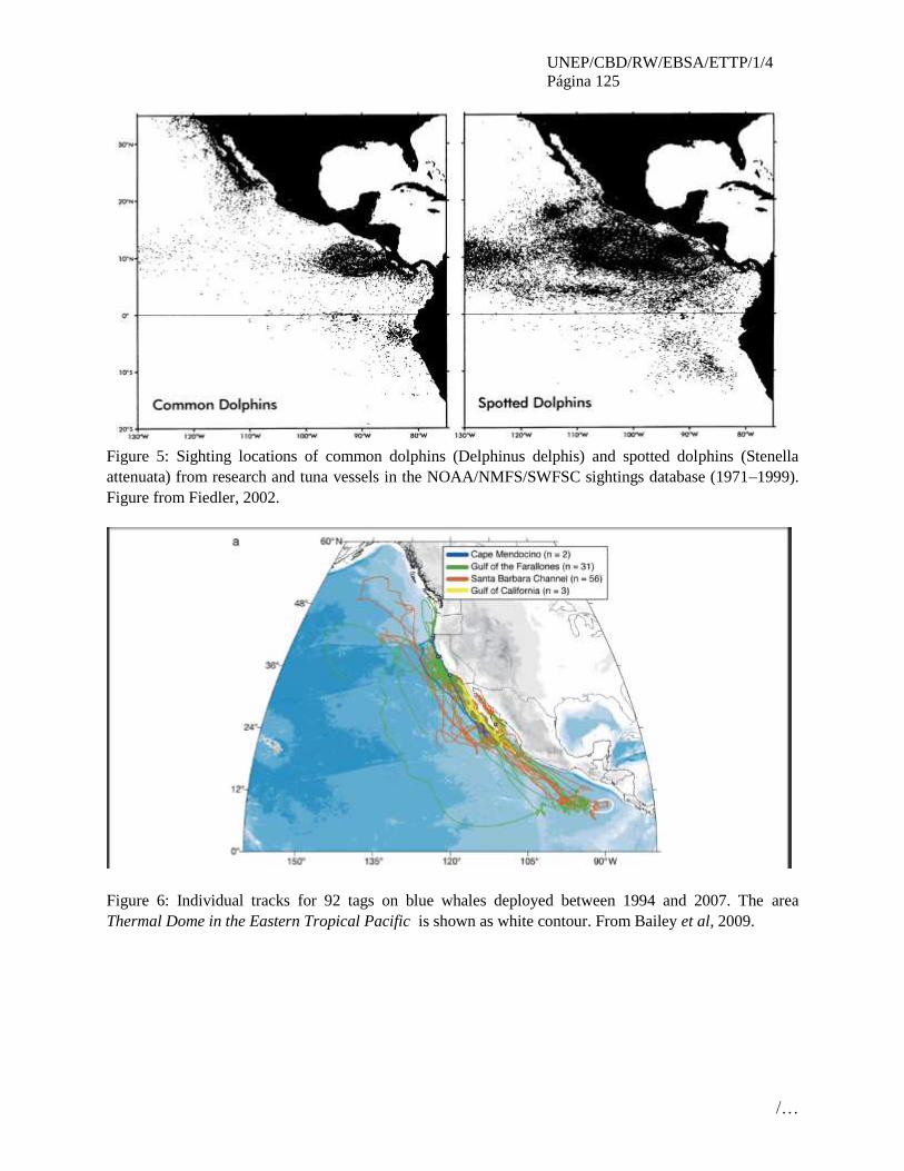
UNEP/CBD/RW/EBSA/ETTP/1/4
Página 125
/…
Figure 5: Sighting locations of common dolphins (Delphinus delphis) and spotted dolphins (Stenella
attenuata) from research and tuna vessels in the NOAA/NMFS/SWFSC sightings database (1971–1999).
Figure from Fiedler, 2002.
Figure 6: Individual tracks for 92 tags on blue whales deployed between 1994 and 2007. The area
Thermal Dome in the Eastern Tropical Pacific is shown as white contour. From Bailey et al, 2009.

UNEP/CBD/RW/EBSA/ETTP/1/4
Página 126
/…
A.
B.
Figure 7: Leatherback turtle migrations. Figure A shows a schematic of turtle migration corridor through
the equatorial current system, based on the 75% home-range utilization distribution contour. Figure B
shows a combined utilization distribution by eastern Pacific leatherback turtles from all tracking data (for
years 2004, 2005 and 2007). Note the presence of the area Thermal Dome in the Eastern Tropical Pacific
in the high utilization area. From Shillinger et al, 2008.
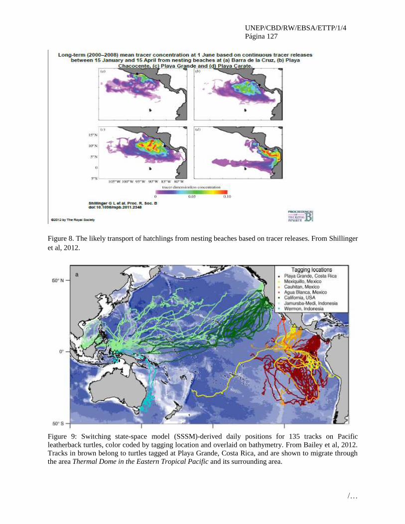
UNEP/CBD/RW/EBSA/ETTP/1/4
Página 127
/…
Figure 8. The likely transport of hatchlings from nesting beaches based on tracer releases. From Shillinger
et al, 2012.
Figure 9: Switching state-space model (SSSM)-derived daily positions for 135 tracks on Pacific
leatherback turtles, color coded by tagging location and overlaid on bathymetry. From Bailey et al, 2012.
Tracks in brown belong to turtles tagged at Playa Grande, Costa Rica, and are shown to migrate through
the area Thermal Dome in the Eastern Tropical Pacific and its surrounding area.

UNEP/CBD/RW/EBSA/ETTP/1/4
Página 128
/…
Figure 10: Dermochelys coriacea. Utilization distribution (UD) of internesting region occupied by 46
leatherback turtles during (a) all years combined. Polygons bordered and cross-hatched in white are Playa
Grande National Marine Park (PNMB) and Santa Rosa National Marine Park (PNMSR).

UNEP/CBD/RW/EBSA/ETTP/1/4
Página 129
/…
Rights and permissions Permission has been received from the authors of the maps and figures used in this submission. In
addition, Drs. Shillinger, Bailey and Hoyt have reviewed the submission and their input has been
incorporated.

UNEP/CBD/RW/EBSA/ETTP/1/4
Página 130
/…
ÁREA NO. 8: CORREDOR MARINO DEL PACIFICO ORIENTAL TROPICAL
(MARINE CORRIDOR EASTERN TROPICAL PACIFIC)
Introducción El Pacífico Oriental Tropical Central (POTC) nace del valor geológico, biológico y los procesos físicos
que abarcan los archipiélagos de Galápagos, Coiba, Las Perlas y la Islas del Coco y Malpelo además de
las aguas circundantes que los rodean. Esta diversidad biológica ha sido reconocida por los cuatro países a
los cuales estas áreas pertenecen (Costa Rica, Colombia, Ecuador y Panamá) que han declarado estas
áreas sitios protegidos y el reconocimiento internacional por la UNESCO al declarar a Galápagos, Coiba,
Coco y Malpelo sitios de Patrimonio Mundial de la Humanidad.
La evidencia científica ha sido presentada, para determinar que las estructuras geomorfológicas del
Pacifico este tropical central, son zonas de alta significancia en términos biológicos y ecológicos y que el
papel que juegan en la conectividad de especies tanto en sus rutas migratorias como en otros momentos
de sus ciclos de vida (apareamiento, nacimiento, alimentación, etc.), permiten asignarles un alto valor
para la conservación de la diversidad marina global.
El origen común de las dorsales de Galápagos, Coiba, Coco y Malpelo, han jugado un rol fundamental
para que sobre estas haya un permanente desplazamiento de poblaciones de tiburones martillo, ballenas
jorobadas, tortugas baula y golfina y aves tales como cormoranes, piqueros y pelicanos, que cumplen sus
ciclos de vida, en relación con estas formaciones geológicas.
De manera complementaria, se han identificado una serie de procesos de surgencia (golfo de Panamá
donde se localiza el archipiélago de Las Perlas en el sector noreste del POTC, y costado occidental del
archipiélago de Galápagos al suroeste del POTC), de diferente origen pero cuyos aportes en productividad
primaria han permitido e incluso promovido, el intenso flujo genético, que se desarrolla al interior del
corredor biológico.
Ubicación
Pacífico oriental tropical central (Ver Figura. 1)
Descripción de las características del área propuesta
El POTC sirve como hábitat crítico para que especies bandera de la región puedan completar etapas
críticas en sus ciclos de vida mediante la migración hacia áreas de reproducción, anidamiento,
nacimiento, aprendizaje temprano en sus etapas iniciales de vida y alimentación. Los procesos altamente
productivos y estaciones de afloramientos eólicos y dinámicos favorecen estos procesos en la región
Condición de las características y perspectivas a futuro de la zona propuesta
El área está sujeta a una tremenda influencia por el fenómeno de El Niño que tiene un significativo
impacto en sobre la productividad, hábitat y especies del área. Igualmente, las áreas de surgencia pueden
jugar un rol en reducir los impactos de El Niño y de servir como refugios durante estos periodos de estrés.
Hay una creciente colaboración internacional para el estudio de las especies altamente migratorias que
está llenando vacíos de información, pero queda mucho por hacer. Hay vacíos de información importante
sobre los fondos profundos y cordilleras submarinas del área. Sin embargo, los elevados costos para
desarrollar estudios y los limitados financiamientos disponibles muchas veces limitan las investigaciones
que pueden llevarse a cabo. Los modelos sobre El Niño deben enfocarse en la Región 1+2 y regiones
contiguas. El área está igualmente sujeta a una presión de pesca de las flotas internacionales de cerco y
palangre que proporcionan poca o ninguna información estadística sobre sus actividades. Puede existir un
potencial peligro por los arrastres en aguas profundas.
UNEP/CBD/RW/EBSA/ETTP/1/4
Página 131
/…
Evaluación del área sobre los criterios EBSA del CDB
Criterios
CBD EBSA
(Anexo I de la
decisión IX/20)
Descripción
(Anexo I de la decisión IX/20) Clasificación de los criterios
pertinentes
No lo se Bajo Alguno Alto
Características
únicas, rarezas
El Corredor Marino del Pacífico
tropical oriental posee un alto grado de
endemismo dado por su historia geológica
común
X
Explicación para la clasificación
Debido a que gran parte del POTC tiene un origen geológico común de islas surgidas muy probablemente
a partir del “punto caliente (hotspot) de Galápagos”, durante el Cretácico y que se han dispersado en
diferentes grados sobre la placa Cocos, al desplazarse hacia la placa Caribe, hasta llegar algunas a la zona
de subducción cerca de la costa de Panamá, donde quedaron adheridas en lugar de hundirse (Hellmann et
al. 1996; Lissinna et al. 2001). Esto ha creado un sinnúmero de ambientes bentónicos de aguas profundas,
pelágicas y costeras, ambientes insulares costeros y oceánicos y mantiene en gran medida una separación
de los cuerpos continentales ha resultado en un alto grado de endemismo en las especies con limitada
posibilidad de movilización pero manteniendo una interconectividad espacial con altas capacidades de
dispersión (Robertson y Allen 2008)
Para Coiba y su área inmediata, el endemismo abarca cuatro especies de octocorales recientemente
descritas. Dos de ellas son endémicas para Coiba, Pacifigorgia catedralensis, que sólo ha sido encontrada
en roca Catedral (Breedy & Guzmán 2004), y Leptogorgia christiae, encontrada solamente en roca Hacha
(Guzmán & Breedy 2008). El octocoral Pacifigorgia rubinoffi, ha sido reportado sólo para ocho
localidades en el golfo de Chiriquí (Breedy & Guzmán 2003), cuatro de las cuales se encuentran dentro
del PN Coiba y contienen el 97% de todos los individuos conocidos para la especie (380 en total).
Pacifigorgia smithsoniana ha sido encontrada principalmente en el PN Coiba. El millepórido
Distichopora robusta se conoce en tres sitios en el golfo de Chiriquí, dos de los cuales, Catedrales y
Jicarita, están localizados en el PN Coiba (Lindner et al. 2004). Igualmente, se reporta el nudibranquio
Herviella sp. (Hermosillo & Valdés 2007).
Para Malpelo se han reportado por lo menos cinco especies endémicas de peces (Robertson y Allen
2008). Para isla del Coco por lo menis unas 20 especies de peces endémicos (Bussing y Burhaus
1991,Garrison 2000). Otras especies únicas de aguas profundas están referenciadas por Cortés y Blum
(2008) para isla del Coco.
Importancia
especial para
las etapas del
ciclo biológico
de especies
EL POTC contiene hábitats esenciales para la
sobreviviencia de varias especies
emblemáticas que requieren del área para
completar sus ciclos de vida.
X
Explicación para la clasificación
Las áreas insulares, costeras y oceánicas del Pacífico oriental tropical central (POTC) juegan un papel
primordial en las diferentes etapas de los ciclos de vida de especies emblemáticas y bandera de la región
que incluyen grupos tan diversos como peces, mamíferos marinos y aves marinas. El rol más evidente del
corredor marino y aéreo es el de interconexión estableciendo una conectividad con las diferentes áreas
geográficas del mismo. Estas especies emblemáticas como el tiburón martillo (Sphyrna lewini) Sibajo-
Cordero, 2008; Bessudo et al., 2011), la ballena jorobada (Megaptera novaeangliae) Flórez-González,
1991; Flórez-González et al. 1998; Rasmussen et al., 2002; Félix y Haase 2005), tortugas baula
(Dermochelis coriácea), verde (Chleonia mydas) y golfina (Lepidochelis olivácea), pelicanos pardos

UNEP/CBD/RW/EBSA/ETTP/1/4
Página 132
/…
(Pelecanus ocidentalis) piqueros (Sula granti, Sula nebouxi, Sula variegata), cormoranes (Phalacrocorax
brasilianus) (Zamudio 2012)
La evidencia científica del rol del Pacífico oriental tropical central en los ciclos migratorios, de
nacimiento, alimentación y crianza de las ballenas jorobadas provenientes de los hemiferios norte y sur
que pasan sus inviernos en la zona es evidente en la región (Herrera-Carmona et al. 2012; Palacios et al.
2012; Flórez-González 1991; Flórez-González et al. 1998; Félix y Haase, 2005), (Guzmán en imprenta;
Rasmussen et al., 2002).
Las grandes agregaciones de tiburón martillo observadas en las islas oceánicas (Sibajo-Cordero, 2008;
Bessudo et al., 2011; Hazin et al., 2001; Bessudo et al., 2012) parecen producir largas migraciones hacia
algunas áreas estaurinas donde recientemente se ha encontrado que dan a luz y completan las primeras
etapas juveniles de su ciclo de vida (Guzmán en imprenta; Vega en imprenta).
Las islas oceánicas y costeras del Pacífico oriental tropical central, sumadas a las áreas de afloramiento de
Galápagos y el golfo de Panamá son importantes áreas para la migración, anidamiento y crianza de las
primeras etapas de vida de un sinnúmero de aves marinas incluyendo piqueros, pelícanos y cormoranes
(Smith 1990; Angher y Kusland 2007)
Importancia de
especies
amenazadas, en
peligro o en
declive y/o
hábitats
El área contiene ecosistemas someros y playas
importantes para los estadios de un sinnúmero
de especies en peligro o amenazadas que le
permite a sus poblaciones la sobrevivencia y
recuperación
X
Explicación para la clasificación
Incluye importantes playas de anidación para la tortuga verde, baula y golfina, luego de atravesar las
diferentes zonas pelágicas del POT, las aguas someras en el golfo de Panamá representan un área
importante para las ballenas jorobadas donde se congregan unas 300 ballenas y se producen unos 20
nacimientos (Guzmán en imprenta). Los tiburones martillos migran a lo largo del POTC (Hearn et al.,
2010, Ketchum 2011) y llegan a aguas someras del POTC donde hay son igualmente sitios importantes
para los nacimientos y crianzas iniciales de tiburones martillos (Guzmán en preparación).
Vulnerabilidad,
fragilidad,
sensibilidad, o
Áreas de lenta
recuperación
Áreas que contengan una proporción
relativamente elevada de hábitats sensibles,
biotopos o especies que son funcionalmente
frágiles (altamente susceptibles a la
degradación o agotamiento por actividades
humanas o por acontecimientos naturales) o
con una lenta recuperación.
X
Explicación para la clasificación
Productividad
biológica
Los extremos noreste y suroeste del área
Pacífico oriental tropical central son áreas con
afloramientos estacionales que incrementan la
productividad biológica
X
Explicación para la clasificación
La productividad biológica estacional del golfo de Panamá (D’Croz el al. 2009, O’Dea 2012) entre
mediados de diciembre a mediados de abril y de Galápagos (Houvenaghel 1984; Palacios et al. 2006)
juega un papel preponderante en los desplazamientos y migraciones de las especies emblemáticas que se
desplazan a lo largo del POTC (O’Dea 2012). Esto es particularmente evidente las aves marinas que
UNEP/CBD/RW/EBSA/ETTP/1/4
Página 133
/…
llegan a estas zonas a anidar y alimentar a sus crías en las fases iniciales después de nacer y hasta que
aprenden a volar. Presentando estas una estacionalidad recurrente a través de los años.
Diversidad
Biológica
Área que contiene una diversidad
relativamente superior de ecosistemas,
hábitats, comunidades, o especies, o tiene una
mayor diversidad genética.
X
Explicación para la clasificación
Hay importantes arrecifes de coral que son los focos de diversidad dentro del POTC (Glynn 2000).
Igualmente, los fondos rocosos son importantes hábitat para octocorales en la región (Guzmán et al. 2004;
Guzmán y Breedy 2008; Breedy y Guzmán 2011). La diversidad de peces en la región es igualmente de
las más altas en la región de Pacífico oriental (Robertson y Allen 2008). La riqueza del área incluye
igulamente ecositemas someros, profundos, montañas someres y playas importantes para un sinuúmero de
especies, incluyendo extensos ecosistemas pelágicos
Naturalidad Área con un grado relativamente mayor de
naturalidad como resultado de la falta o bajo
nivel de perturbación de origen humano o
degradación.
X
Explicación para la clasificación
Hay cierto grado de explotación de los recursos pesqueros tanto a nivel industrial como artesanal en las
zonas costeras, dirigidas estas principalmente a especies pelágicas de amplia distribución como atunes,
dorados, tiburones, peces pico entre otras.
Referencias
Agujetas J, Mitchelson-Jacob J, Mair JM (2008) Seasonal upwelling and primary
production of the Gulf of Panama: ENSO implications. Poster
Allen, R.G and Robertson, D.R., 1998. Fishes of the Tropical Eastern Pacific. Crawford
House Press PTY Ltd. Publisher in the USA Hawai University Press. 327 p
Angher GR, Kusland JA (2007) Seabird and Colonial Wading Bird Nesting in the Gulf of
Panama. Waterbirds 30(3): 335-357
Breedy, Odalisca; Guzman, Hector M. 2011. A revision of the genus Heterogorgia
Verrill, 1868 (Anthozoa: Octocorallia: Plexauridae). Zootaxa, 2995: 27-44
Birkeland, C., Meyer, D.L., Stames J.P and. Buford, C. L., 1975. Subtidal communities
of Malpelo island. In: The Biological Investigation of Malpelo island, Colombia. J.
Graham (Ed). Smithsonian Institution Press No. 176: 55-68
Brando, A, Prahl H.V. and. Cantera, J.R., 1992. Malpelo Isla Oceánica de Colombia.
Banco de Occidente. 195 p.
Breddy O, Guzmán HM (2004) A new species of Pacifigorgia (Coelenterata:
Octocorallia: Gorgoniidae) from Pacific Panamá. Zootaxa 541:1-15
CDB. 2008. Convention on Biological Diversity, Synthesis and review of the best
available scientific studies on priority areas for biodiversity conservation in marine areas
beyond the limits of national jurisdiction. UNEP/CBD/SBSTTA/13 /INF/11. 52 p.
Cortés, J. & S. Blum. 2008. Life to 450 m depth at Isla del Coco, Costa Rica. Revista de
Biología Tropical 56 (Suppl. 2): 189-206.
D'Croz, Luis; O'Dea, Aaron. 2009. Nutrient and chlorophyll dynamics in Pacific Central
America (Panama). In: Lang, Michael A., MacIntyre, Ian G. and Ruetzler, Klaus,

UNEP/CBD/RW/EBSA/ETTP/1/4
Página 134
/…
Proceedings of the Smithsonian Marine Science Symposium. Washington DC:
Smithsonian Institution Scholarly Press, (Smithsonian Contributions to the Marine
Sciences) pp.335-344.
Devis-Morales, A., W. Schneider, R. A. Montoya-Sánchez y E. Rodríguez-Rubio. 2008.
Monsoon-like winds reverse oceanic circulation in the Panama Bight. Geophys. Res.
Lett., 35 L20607: 1-6.
Freiwald, A., Fossa, J., Grehan, A., Koslow, T. & M. Roberts. 2004. Cold-Water coral
reefs: Out of sight, no longer out of mind. UNEP-WCMC, Cambridge, UK.
Glynn PW, Ault JS (2000) A biogeographic analysis and review of the far eastern Pacific
coral region. Coral Reefs 19:1-23
Guzmán HM, Breedy O (2008) Leptogorgia christiae (Octocorallia: Gorgoniidae) a new
shallow water gorgonian from Pacific Panama. Journal of the Marine Biological
Association of the UK. 88:719-722
Guzmán H, Guevara CA, Breedy 0 (2004) Distribution, diversity, and conservation of
coral reefs and coral communities in the largest protected area of Pacific Panama (Coiba
Island). Environmental Conservation 31(2):111-121
Hellmann W, Krawinkel J, Seyfried H (1996) Struktur und kinematik eines Forearc
Terranes imWestpanamá-Segment (Azuero-Soná-Terrane). http://www.geowiss.uni-
hamburg.de/i-geolo/lak_1996/wkraw1.htm
Hearn A, Ketchum JT, Klimley AP, Espinoza E (2010) Hotspots within hotspots?
Hammerhead shark movements around Wolf Island, Galapagos Marine Reserve. Marine
Biology 157: 1899-1915
Houvenaghel GT (1984) Oceanographic setting of the Galápagos Islands. In: Perry R (ed)
Galapagos (key environments). Pergamont Press, Oxford, pp 43-54
INVEMAR, 2004. Informe del estado de los ambientes marinos y costeros en Colombia:
Año 2003. Serie de Publicaciones Periódicas. Número 8. Santa Marta, Colombia.
Ketchum JT (2011) Movement Patterns and Habitat Use of Scalloped Hammerhead
Sharks (Sphyrna lewini) in the Galapagos Islands: Implications for the Design of Marine
Reserves. Doctoral Dissertation. University of California190 pp
Lauren T. Toth, Richard B. Aronson, Steven V. Vollmer, Jennifer W. Hobbs, Dunia H.
Urrego, Hai Cheng, Ian C. Enochs, David J. Combosch, Robert van Woesik, Ian G.
Macintyre (2012) ENSO Drove 2500-Year Collapse of Eastern Pacific Coral Reefs.
Science. 337: 81-84
Lissinna B, Hoernle K, Bogaard P van den, Werner R (2001) New Evidences for Ocean
Island
Accretion in Western Panamá. Resumen en EUG XI. Symposium 0S09. Geochemistry
Lonsdale, P., y K. D. Klitgord. 1978. Structure and tectonic history of the eastern Panama
Basin. Geol. Soc. Am. Bull., 89: 981-999.
López-Victoria, M. y D. M. Rozo. 2006. Model-based geomorphology of Malpelo Island
and spatial distribution of breeding seabirds. Bol. Invest. Mar. Cost., 35:111-131.
O'Dea, Aaron; Hoyos, Natalia; Rodríguez, Félix; De Gracia, Brigida; De Gracia, Carlos.
2012. History of upwelling in the Tropical Eastern Pacific and the paleogeography of the

UNEP/CBD/RW/EBSA/ETTP/1/4
Página 135
/…
Isthmus of Panama. Palaeogeography, Palaeoclimatology, Palaeoecology, 348/349: 59-
66.
Palacios DM, Bograd SJ, Foley DG, Schwing FB (2006) Oceanographic characteristics
of biological hot spots in the North Pacific: A remote sensing perspective. Deep-Sea
Research II 53 250–269
Rodríguez-Rubio, E., W. Schneider y R. Abarca del Rio. 2003. On the seasonal
circulation within the Panama Bight derived from satellite observations of wind, altimetry
and sea surface temperature. Geophys. Res. Lett., 30 (7): 1410.
Ruíz A, Rodríguez J (2011) Caracterización de las playas de anidación de tortugas
marinas en el Parque Nacional Coiba, provincia de Veragüas, Panamá. Reporte Técnico.
139 p
Sallarés, V. P. Charvis, E. R. Flueh y J. Bialas. 2003. Seismic structure of Cocos and
Malpelo volcanic ridges and implications for hot spot-ridge interaction. J. Geophys. Res.,
108 (b12): 2564. doi:10.1029/2003jb002431
Smith NG (1990) The Gulf of Panamá and El Niño Events: The Fate of the two refuge
boobies from the 1982-83 event. In Global Consequences of the 1982-83 El Niño-
Southern Oscillation. Ed. PW Glynn. Elsevier, Amsterdam
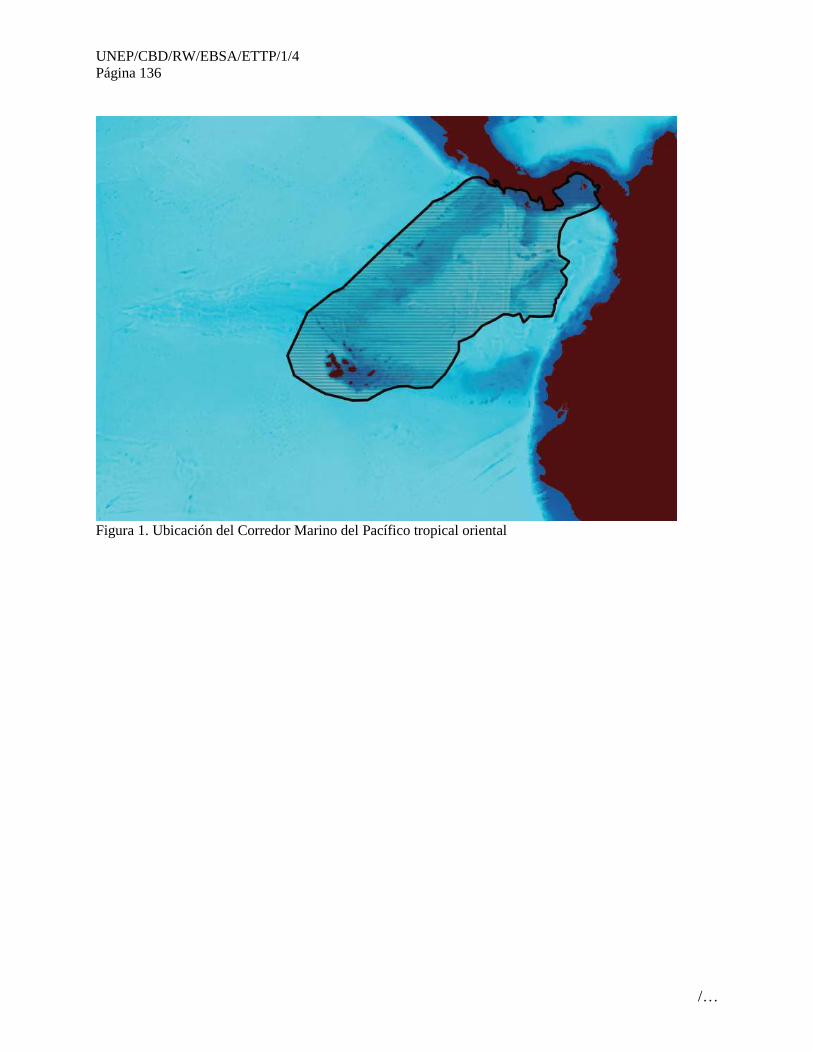
UNEP/CBD/RW/EBSA/ETTP/1/4
Página 136
/…
Figura 1. Ubicación del Corredor Marino del Pacífico tropical oriental

UNEP/CBD/RW/EBSA/ETTP/1/4
Página 137
/…
Figura 2. Afloramiento estacional en el golfo de Panamá (mediados de diciembre a mediados de abril).
Agujetas J, Mitchelson-Jacob J, Mair JM (2008) Seasonal upwelling and primary production of the Gulf
of Panama: ENSO implications. Poster
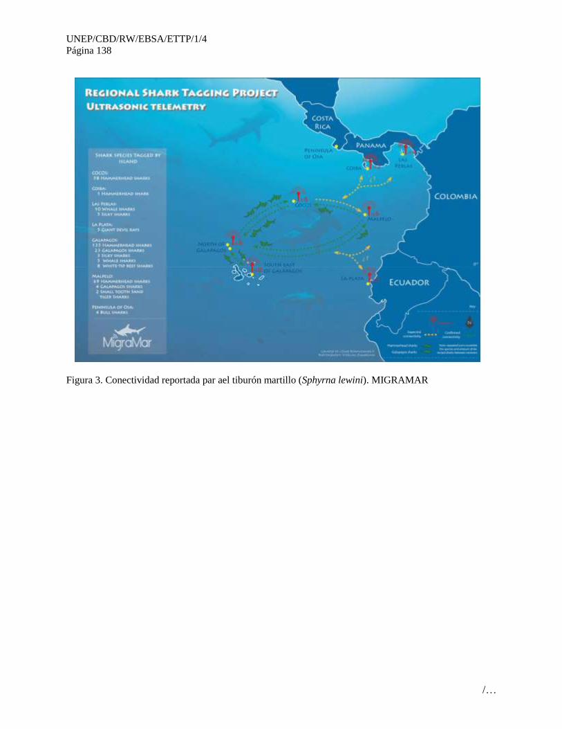
UNEP/CBD/RW/EBSA/ETTP/1/4
Página 138
/…
Figura 3. Conectividad reportada par ael tiburón martillo (Sphyrna lewini). MIGRAMAR
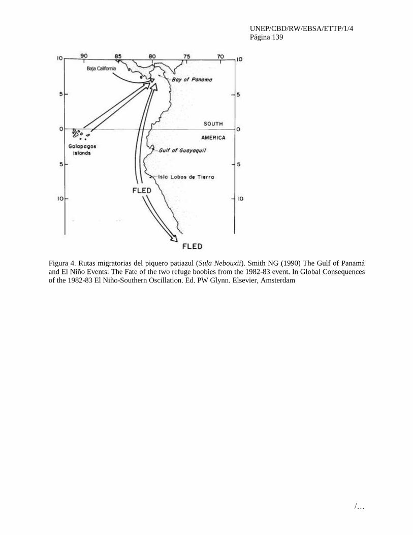
UNEP/CBD/RW/EBSA/ETTP/1/4
Página 139
/…
Figura 4. Rutas migratorias del piquero patiazul (Sula Nebouxii). Smith NG (1990) The Gulf of Panamá
and El Niño Events: The Fate of the two refuge boobies from the 1982-83 event. In Global Consequences
of the 1982-83 El Niño-Southern Oscillation. Ed. PW Glynn. Elsevier, Amsterdam

UNEP/CBD/RW/EBSA/ETTP/1/4
Página 140
/…
UNEP/CBD/RW/EBSA/ETTP/1/4
Página 141
/…
ÁREA NO. 9: ZONA ECUATORIAL DE ALTA PRODUCTIVIDAD
(EQUATORIAL HIGH-PRODUCTIVITY ZONE)7
Abstract
The Pacific Ocean equatorial high productivity zone is a large-scale oceanographic feature associated
with the Equatorial Current System. It comprises almost the entire width of the Pacific Basin, but is
limited to a narrow band spanning the equator. The thermocline in this region shoals from west to east
due to wind forcing, bringing waters with high nutrient content near the surface and leading to elevated
primary production relative to the adjacent waters to the north and south. There is strong benthic-pelagic
coupling, with benthic secondary production in the 4000-5000m abyssal plains being strongly related to
the surface primary productivity. Historically high sperm whale abundance was recorded in this area. This
feature is highly influenced by El Nino events and is potentially susceptible to climate change. This area
is rated “high” for uniqueness, due to its large scale as well as being a major component of the
oceanographic processes within the Pacific Ocean; it is also rated as “high” for primary productivity.
Introduction
Two trans-Pacific currents are responsible for this system. At depth, the Equatorial Undercurrent (EUC,
also known as the Cromwell Current) originates in Indonesia and flows from west to east within the
thermocline, carrying high nutrients and dissolved metals like iron and cadmium of terrigenous sources
(Johnson et al. 2002; Kessler, 2006). At the surface, the South Equatorial Current (SEC) is the equatorial
extension of the Humboldt Current along the coast of South America and flows west along the equator
into the central Pacific (Ganachaud et al. 2011). The thermocline rises from west to east and in the eastern
Pacific it is so shallow that it surfaces, forming a “cold tongue” by the influence of the the Southeast
Trade Winds. The upwelled waters are high in macronutrients (nitrate, phosphate, silicate) and
micronutrients (iron and cadmium), resulting in high primary production along the equator, which is
linked to high benthic secondary production (Chavez et al. 1999). Underlying this pelagic area is abyssal
flat sedimented plains and lower bathyal deep-water trenches, between 4000 and 5000m deep (Harris and
Whiteway 2009). Distribution of mieofaunal (63-300µm) and macrofaunal (300µm-3mm) abundance and
biomass have been shown to be highly correlated to surface primary productivity, indicating strong
linkages between surface primary production and benthic secondary production (ISA 2010). In the
Central and Western Pacific the thermocline is deep and the associated “warm pool” is a closely related
oceanographic feature, which is associated with high rainfall causing lower salinity and warmer
conditions, down to approximately 100m depth (Cravatte et al. 2009). Primary and secondary
productivity between the “cool tongue” and the “warm pool” have potential linkages, in part through the
Eastern Warm Pool Convergence Zone (Grandperrin 1978; Lehodey 2001; Picaut et al. 2001; Lehodey et
al. 2011).
Location
This open-ocean system is located from latitudes of approximately 5° N to 5° S of the equator, and
longitudes of approximately 165° E to the Galápagos Islands. The area includes waters outside of national
jurisdiction but also includes areas with the EEZ of Kirbati, as well as Palmyra Atoll, Jarvis Island and
7As adopted by the western south pacific regional workshop to facilitate the description of ecologically or
biologically significant marine areas, Fiji, 22- 25 November 2011; Expanded/modified by the Galapagos
EBSA workshop, August 2012
UNEP/CBD/RW/EBSA/ETTP/1/4
Página 142
/…
Howard Island (USA), the Marshall Islands and Nauru in the western Pacific. In the eastern Pacific the
equatorial system of upwelling extends to the coast of South America but the presence of the Galápagos
Islands (Ecuador) causes major modification and a separate area meeting EBSA criteria has been
identified in this area. Further to the east the system is connected with the Humboldt Current and another
area meeting EBSA criteria has been proposed by Ecuador in this area in recognition of particular features
that distinguish it.
Feature description of the proposed area
This is primarily a pelagic feature in the equatorial Pacific Ocean. The feature comprises the EUC and the
SEC, and as such is a component of a much larger ocean system that extends across the Pacific to the
Americas. These currents are strongly influenced by El Nino events (Cane 1983). The area is
characterized by high kinetic energy and high front density, both measures of ocean boundaries and
indicators of areas with high productivity (Cagula and Cornillon 1995; Zainuddin et al. 2006). Associated
with the area are high surface nutrient concentrations of nitrate, phosphate and silicate (Ridgway 2002).
Related to these physical and chemical features, direct evidence of high primary productivity, as
evidenced by SeaWIFS satellite-based estimates of chlorophyll-a (fig. 7) and VGPM productivity models
have been measured (fig. 8). The high primary productivity within this area is linked to benthic secondary
production (ISA 2010) and has possible links to high secondary production, further west in the “warm
pool” oceanographic feature (Grandperrin 1978; Lehodey 2001; Lehodey et al. 2011). Additionally, both
historical records of high capture rates for sperm whales (Townsend 1931; 1935), and current mammal
observations (OBIS 2011), are supported by this highly productive area.
Feature condition and future outlook of the proposed area
The area is currently in good condition; there is evidence of human activity in the high historic catch of
sperm whales relative to current observations (Townsend 1931; 1935). The area is remote, however, is
commercially fished and may be vulnerable to climate change (Ganachaud et al. 2011).
Assessment of the area against CBD EBSA Criteria
This area comprises the equatorial divergence, a major oceanographic feature of the Pacific Ocean, as
well as the interaction of this upwelling zone with a major surface feature of the western central Pacific; it
is therefore (highly) unique. One of the main characteristics of the area is its high primary and secondary
productivity in the “cold tongue”, and its extremely high secondary productivity in the “warm pool”
region; thus the area also receives a high ranking for biological productivity due to the very large extent
of the area and the rate of productivity. Finally, this area is highly vulnerable; historically this has been
shown from the very high historical catches of sperm whales, which are no longer present. The area is
also highly vulnerable to the impacts of climate change, and the subsequent changes to oceanographic
patterns.
CBD EBSA
Criteria
(Annex I to
decision
IX/20)
Description
(Annex I to decision IX/20) Ranking of criterion relevance
Don’t
Know
Low Some High
Uniqueness
or rarity
Area contains either (i) unique (“the only one of
its kind”), rare (occurs only in few locations) or
endemic species, populations or communities,
and/or (ii) unique, rare or distinct, habitats or
ecosystems; and/or (iii) unique or unusual
X

UNEP/CBD/RW/EBSA/ETTP/1/4
Página 143
/…
geomorphological or oceanographic features
Explanation for ranking
The immense size of the area and its location at the westerly extreme of a major Pacific oceanographic
feature, make it globally unique.
Special
importance for
life-history
stages of
species
Areas that are required for a population to
survive and thrive. X
Explanation for ranking
This area has not been identified as specifically important for life-history stages of particular species,
despite high observation effort.
Importance for
threatened,
endangered or
declining
species and/or
habitats
Area containing habitat for the survival and
recovery of endangered, threatened, declining
species or area with significant assemblages of
such species.
X
Explanation for ranking
This area has not been identified as specifically important for threatened, endangered or declining species,
despite high observation effort.
Vulnerability,
fragility,
sensitivity, or
slow recovery
Areas that contain a relatively high proportion
of sensitive habitats, biotopes or species that
are functionally fragile (highly susceptible to
degradation or depletion by human activity or
by natural events) or with slow recovery.
X
Explanation for ranking
Even though in the high seas, this area has seen large-scale change, such as the decline in whale
abundance due to harvesting. Climate change may cause changes to the strength of upwelling, altering
nutrient cycling and primary production processes.
Biological
productivity
Area containing species, populations or
communities with comparatively higher
natural biological productivity.
X
Explanation for ranking
This area has high primary productivity, over a large area of the Pacific Ocean (1000s of square
kilometres). Evidence is provided in chlorophyll a and historical high sperm whale captures (Townsend
1931; 1935). There is additionally evidence of linkages to secondary fisheries production (Grandperrin
1978; Lehodey 2001; Lehodey et al. 2011).
Biological
diversity
Area contains comparatively higher diversity
of ecosystems, habitats, communities, or
species, or has higher genetic diversity.
X
Explanation for ranking
This area does not have notably high biological diversity.
Naturalness Area with a comparatively higher degree of
naturalness as a result of the lack of or low
level of human-induced disturbance or
X
UNEP/CBD/RW/EBSA/ETTP/1/4
Página 144
/…
degradation.
Explanation for ranking
There has been a long history of human use of the resources in this area, directly related to the
significance of the area as a highly productive open-ocean area.
References
Cane, M.A. (1983) Oceanographic events during El Nino. Science 222(4629): 1189-1195
Cayula J-F, Cornillon P (1995) Multi-Image Edge Detection for SST Images. Journal of
Atmospheric and Oceanic Technology 12: 821-829.
Chavez, F.P., Strutton, P.G., Friederich, G.E., Feely, R.A., Feldman, G.C., Foley, D.G.
and McPhaden, M.J. 1999. Biological and Chemical Response of the Equatorial Pacific
Ocean to the 1997-98 El Niño. Science 286(5447): 2126-2131
Cravatte, S., Delcroix, T., Zhang, P., McPhaden, M. and Leloup, J. 2009. Observed
freshening and warming of the western Pacific warm pool. Climate Dynamics 33(4): 565-
589
Ganachaud, A.S., Gupta, A.S., Orr, J.C., Wijfels, S.E., Ridgway, K.R., Hemer, M.A.,
Maes, C., Steinberg, C.R., Tribollet, A.D., Qui, B. and Kruger, J.C. (2011). Observed and
expected changes to the tropical Pacific Ocean. In Bell J., Johnson JE, Hobday AJ (Ed.),
Vulnerability of Tropical Pacific Fisheries and Aquaculture to Climate Change.
Secretariat of the Pacific Community. Noumea New Caledonia.
Grandperrin, R. (1978) Influence of currents on the production of tropical seas:
consequences for fisheries. Fisheries Newsletter No. 17, South Pacific Commission,
Noumea, New Caledonia. pp 14 -20.
Harris and Whiteway 2009. High seas marine protected areas: Benthic environmental
conservation priorities from a GIS analysis of global ocean biophysical data. Ocean &
Coastal Management 52: 2238. doi:10.1016/j.ocecoaman.2008.09.009
http://www.gebco.net/data_and_products/
International Seabed Authority. 2010. Development of geological models for the
Clarion-Clipperton Zone polymetallic nodule deposits. – (ISA technical study no.6),
ISBN: 978-976-95268-2-2 (pkb).
Johnson, G.C, B.M. Sloyan, W.S. Kessler, and K.E. McTaggart. 2002. Direct
measurements of upper ocean currents and water properties across the tropical Pacific
during the 1990ís. Progress in Oceanography 52(1):31ñ61.
Kessler, W S. 2006. The Circulation of the Eastern Tropical Pacific: a Review. Progress
in Oceanography 69: 181–217. doi:10.1016/j.pocean.2006.03.009.
Lehodey, P. 2001. The pelagic ecosystem of the tropical Pacific Ocean: Dynamic spatial
modelling and spatial consequences of ENSO. Progress in Oceanography 49: 439-468.
Lehodey, P., Hampton, J., Brill, R.W., Nicol, S., Senina, I., Calmettes, B., Pörtner, H.O.,
Bopp, L., Ilyina,T., Johann D. Bell, and J. Sibert (2011). Vulnerability of oceanic
fisheries in the tropical Pacific to climate change. In Bell J., Johnson JE, Hobday AJ
UNEP/CBD/RW/EBSA/ETTP/1/4
Página 145
/…
(Ed.), Vulnerability of Tropical Pacific Fisheries and Aquaculture to Climate Change.
Secretariat of the Pacific Community. Noumea New Caledonia.
Mincks, S.L., C.R. Smith (2006) Critical review of benthic biological data from the
Clarion-Clipperton Fracture Zone (CCZ) and adjoining areas. Report to the International
Seabed Authority, Geological Model Phase II. 23 pp
OBIS, 2011. http://www.iobis.org/
Picaut, J., Iovalalen, M., Delcroix, T., Masia, F., Murtugudde, R. and Vialard, J. 2001.
The oceanic zone of convergence on the eastern edge of the Pacific warm pool: A
synthesis of results and implications for El Niño-Southern Oscillation and
biogeochemical phenomena. Journal of Geophysical Research 106 (C2): 2363-2386
Ridgway K.R., J.R. Dunn, and J.L. Wilkin (2002). Ocean interpolation by four-
dimensional least squares -Application to the waters around Australia. Journal of
Atmospheric and Ocean Technology, Vol 19, No 9, 1357-1375
SeaWIFS. http://seawifs.gsfc.nasa.gov/SEAWIFS/LICENSE/checklist.html.
Townsend, C.H. (1931) Where the nineteenth century whaler made his catch. Zoologica
34, No. 6:173-179.
Townsend, C.H. (1935) The distribution of certain whales as shown by logbook records
of American whaleships. Zoologica 19, No. 1:1-50, 4 charts.
Using multi-sensor satellite remote sensing and catch data to detect ocean hot spots for
albacore (Thunnus alalunga) in the northwestern North Pacific. Deep-Sea Research II
53,: 419-431.
Zainuddin M, Kiyofujia H, Saitohb K, Saitoh S-I (2006) Using multi-sensor satellite
remote VGPM productivity model.
http://www.science.oregonstate.edu/ocean.productivity/45

UNEP/CBD/RW/EBSA/ETTP/1/4
Página 146
/…
Maps and Figures
Figure 1: Area meeting EBSA criteria
UNEP/CBD/RW/EBSA/ETTP/1/4
Página 147
/…
ÁREA NO. 10: ARCHIPIÉLAGO DE GALÁPAGOS Y PROLONGACIÓN OCCIDENTAL
(GALAPAGOS ARCHIPELAGO AND WESTERN EXTENSION)
Introducción
Las islas Galápagos son ecosistemas que guardan gran diversidad de especies endémicas que hoy en día se
encuentran protegidas por la Reserva Marina de Galápagos (RMG). La RMG comprende toda el área
dentro de una franja de 40 millas náuticas (mn) medidas a partir de la “línea base” que rodea el
archipiélago. El ecosistema de Galápagos contiene una amplia biodiversidad de especies, que están
distribuidas en diferentes hábitats marinos, que no solamente son reflejo de la geología y variada
oceanografía, sino también de su variabilidad intra e inter anual. (Banks, 2002).
Gracias a la instalación de transmisores satelitales en tortugas marinas (Chelonia mydas) post-anidadoras
se puso de manifiesto que los individuos se mueven más allá de la zona protegida por la reserva marina,
emprendiendo migraciones hacia las costas de América Central y América del Sur (Seminoff et al. 2008).
Existen evidencias que durante estos movimientos las tortugas verdes, son vulnerables a interacciones con
pesquerías industriales (Seminoff et al 2008). Varios estudios realizados en otras especies asociadas al
archipiélago (tiburones, ballenas, marlins, albatros, etc.) demuestran patrones de migración constantes por
parte de estas especies. Durante estos movimientos los individuos antes mencionados, son vulnerables
tanto a interacciones con pesquerías industriales como a la de colisiones con embarcaciones grandes que
se encuentren de tránsito.
Existe una constante ocurrencia de especies en la región (3464 invertebrado marinos, 684 peces y la lista
sigue incrementándose), lo que demuestra la importancia de esta área marina en cuanto a sus niveles de
diversidad y endemismo; además de ser una representación biogeografía del Pacifico este tropical (PET).
Los altos niveles de biodiversidad en la región están asociados a su elevada productividad primaria, la
cual no solamente se encuentra al interior de la RMG (por el “efecto isla”, Palacios 2002) sino que
prevalece en hábitats que se encuentran más alejados de las costas como los montes marinos, el declive de
la plataforma, los planos abisales y bentos hidrotérmicos (Banks 2002, Palacios et al. 2006), generando un
ambiente oceanográfico único y complejo que contribuyen a la alta diversidad existente en Galápagos
(Bustamante el al. 2009).
Ubicación
El archipiélago de Galápagos se encuentra a unos 1000 km de la costa de Ecuador. Es una región de
continua confluencia de aspectos atmosféricos y biológicos que decantan en una especialización
importante para la región. El área que se propone comprende un área de 585.914 km2 entre las
coordenadas 95.2477°O; 3.6744° N; 87.2051°O; 3.4350°S. Comprende la Reserva Marina de Galápagos
y se extiende hacia su parte oeste, noroeste y en menor extensión hacia la parte este y sur. Se encuentra
dentro de la ZEE de Ecuador. Es importante mencionar que los límites actuales de la región oeste pueden
mejorarse tomando en cuenta los valores de Chl-a elevados (un promedio mayor de 0.5 mg.chl-a, se
sugiere m-3). Este parámetro define e incluye el ecosistema pelágico productivo, así como las áreas de
menor productividad para asegurar representación de habitantes con características distintas. Además,
Chl-a incluye los frentes oceánicos significativos que se extiendan al oeste de las islas y se contempla
también las teleconexiones entre la productividad primaria generada por el efecto local de afloramiento
contra la plataforma de Galápagos, lo cual está localizado al oeste en pulsos aperiódicos pero extensivos
en espacio. La extensión al este incluye principalmente los bajos importantes que están fuera de los
límites de la Reserva Marina de Galápagos, los cuales son conocidos como zonas de forrajeo de especies
residentes en las islas y migratorias.

UNEP/CBD/RW/EBSA/ETTP/1/4
Página 148
/…
Descripción de las características del área propuesta
Esta área incluye las aguas interiores del archipiélago de Galápagos y sus alrededores, donde las
cordilleras submarinas juegan un rol importante como hábitats que abarcan una diversidad de especies
que cumplen diferentes roles ecológicos (alimentación, reproducción, migración, etc.), cuyos criterios de
importancia, resaltan y mantienen las zonas de forrajeo asociados a mega fauna; las cuales generalmente
se encuentran asociadas a frentes de surgencia acompañados de una elevada productividad.
Por su ubicación, las islas se encuentran en la línea ecuatorial dentro del Pacifico central oriental tropical,
en la región hay una confluencia de corrientes de distintas características provenientes de los hemisferios
sur y norte, combinado con afloramientos locales sumamente productivos y localizados al oeste. El
principal efecto es la generación de tele-conexiones entre sistemas productivos tanto dentro la reserva
como en aguas meso-pelágicos sobre la plataforma de Galápagos. Esto se combina con frentes oceánicos
y afloramientos productivos los cuales se extienden al oeste por fuera de los límites de la RMG.
Existe hipótesis acerca de que la mezcla de masas de aguas tropicales y templadas dentro de una zona
mayoritaria de refugio protegida de la pesca industrial en la RMG facilita intercambios entre poblaciones
de especies pelágicas a gran escala en el Pacifico norte y sur.
Condición de las características y perspectivas a futuro de la zona propuesta
Es una de las áreas marinas protegidas más importantes de la región, regida por el gobierno de la
república de Ecuador, bajo un régimen legal especial, con un principio de manejo adaptativo y
participativo, cuenta con un área de aproximadamente 133.000 km2. Por ser considerado un laboratorio
viviente es uno de los sitio estudios donde permanente se está generado información científica de alto
nivel, un ejemplo de este desarrollo científico lo reporta Santander (2006), quien menciona que entre los
años 1535 y 2007 se han elaborado alrededor de 10,081 publicaciones científicas basados en este lugar.
El archipiélago alberga una gran cantidad de especies vulnerables, por lo que dada la fragilidad del
ecosistema y alto grado de endemismo llama la atención mundial, el mantener su flora y fauna mejor
conservada. Hasta ahora la zona de Galápagos cuenta con mucha información acerca de los procesos
terrestres y costeros – sin embargo existe la necesidad de ampliar los estudios de sistemas pelágicos de
cara a un creciente uso de aguas internacionales e insulares por la pesca artesanal y así aplicar un mejor
sistema integrado de monitoreo biofísico.
El área propuesta también se encuentra en una zona influenciada por la elevada variabilidad climática.
Eventos fuertes de El Niño Oscillation del Sur (ENOS) tanto fríos como cálidos han afectado la zona
intensamente a lo largo de este siglo. Frente a esas perturbaciones el área propuesta representa una
oportunidad para entender mejor los rangos ambientales dentro de los cuales los ecosistemas pelágicos
responden e interactúan con actividades antrópicos en la región. Siendo, este aspecto, hasta cierto punto
un candidato ideal como estación de monitoreo de largo plazo de interés global. Este efecto se extiende a
la costa de Suramérica, y por su rol como nexo oceánico con otras áreas co-dependientes en la Pacifico
este tropical (PET) (como las AMP del corredor marino del PET y el continente). El área que extienda
fuera al oeste de la RMG es particularmente importante por ser una zona de transición, observado en los
últimos años como transición entre el estado "Modoki" y clásico de El Niño
Evaluación del área sobre los criterios EBSA del CDB
Criterios
CBD EBSA
(Anexo I de la
Descripción
(Anexo I de la decisión IX/20) Clasificación de los criterios
pertinentes
No lo se Bajo Alguno Alto

UNEP/CBD/RW/EBSA/ETTP/1/4
Página 149
/…
decisión IX/20)
Características
únicas, rarezas
Área de singularidad o rareza contiene ya sea
(i) exclusivas («la única de su clase"), raras
(sólo ocurre en pocos lugares) o de especies
endémicas, poblaciones o comunidades, y / o
(ii) único, raro o distinto, los hábitats o los
ecosistemas, y / o (iii) características
geomorfológicos u oceanográficos exclusivos
o desacostumbrados.
X
Explicación para la clasificación:
Considerada como la reserva marina más grande en el Pacifico oriental y una de las más conocidos a nivel
mundial, ha sido escenario de varias expediciones científicas, y categorizada un laboratorio vivo por la
comunidad científica mundial. Ha obtenido varios reconocimientos internacionales, como Patrimonio de la
Humanidad (declarada por la UNESCO), Santuario de Ballenas, Reserva de la Biosfera, Zona
Especialmente Sensible OMI entre otros.
Es un área que presenta claros patrones de una elevada productividad primaria, con relación a otras áreas en
la zona del Pacífico oriental en los trópicos. Donde en base a estudios científicos se ha demostrado que es
una importante zona de tránsito regular para especies migratorias (Palacios 2004).
Varios estudios hacen referencia que la región oeste del archipiélago de Galápagos muestra una gran
influencia de corrientes oceánicas superficiales y sub-superficiales que convergen, provocando un alto grado
de afloramiento, que deriva en un incremento de la abundancia y diversidad de especies dentro de la trama
trófica entre las cuales están varias especies migratorias así como también especies batipelágicas exclusivas
de los montes submarinos. Palacios (2004) menciona que la productividad marina existente en la zona oeste
del archipiélago ocasiona el desarrollo de varios procesos ecológicos vitales como: eficiencia de forrajeo,
reproducción, migración, entre otros.
En la zona habitan 31 especie marinas endémicas, de las cuales, siete son aves, 8 son invertebrados, dos
mamíferos, un reptil y 13 peces (Echeverría et al., 2011).
Importancia
especial para
las etapas del
ciclo biológico
de especies
Las áreas requieren una población para
sobrevivir y prosperar.
X
Explicación para la clasificación
El archipiélago de Galápagos, por la influencia que tiene del sistema de corrientes, es un área que ha sido
identificada como de alta productividad y afloramientos (Palacios et al. 2006), los cuales albergan áreas de
crianza para varias especies de importancia ecológica, como el caso de los tiburones punta Negra
(Carcharinus limbatus) y Martillo (Sphyrna lewini). Estos organismos prefieren las zonas costeras rodeadas
de manglar para protegerse de depredadores más grandes durante su estadio neonatal y juvenil, siendo estos
hábitats de gran importancia para la conservación de estas especies consideradas claves para la RMG
(Llerena 2010).
El programa de monitoreo de los estadios larvales en las zonas costeras de langosta ha demostrado la
importancia del archipiélago de Galápagos como sitio de agregación larval, además de las aguas abiertas del
archipiélago para las tres especies de langosta que habitan en las islas (Espinoza 2009).
Por otra parte se han detectado una elevada abundancia de cetáceos alrededor del archipiélago, especies que
utilizan este ecosistema para albergar clanes enteros que llegan a alimentarse; este es el caso de las ballenas
jorobadas, orcas y cachalotes; cuya estructura de talla involucra diferentes estadios de su ciclo de vida
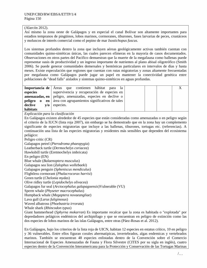
UNEP/CBD/RW/EBSA/ETTP/1/4
Página 150
/…
(Alarcón 2012).
Así mismo la zona oeste de Galápagos y en especial el canal Bolívar son altamente importantes para
estadios tempranos de pingüinos, lobos marinos, cormoranes, tiburones, fases larvarias de peces, crustáceos
y moluscos de interés comercial como el pepino de mar Isostichopus fuscus.
Los sistemas profundos dentro la zona que incluyen aéreas geológicamente activas también cuentan con
comunidades quimo-sintéticas únicas, las cuales parecen efímeras en la mayoría de casos documentados.
Observaciones en otros partes del Pacifico demuestran que la muerte de la megafauna como ballenas puede
representar oasis de productividad y un ingreso importante de nutrientes al plano abisal oligotrófico (Smith
2006). Se puede generar comunidades demersales y bentónicas particulares en intervalos de días y hasta
meses. Existe especulación que regiones que cuentan con rutas migratorias y zonas altamente frecuentadas
por megafauna como Galápagos puede jugar un papel en mantener la conectividad genética entre
poblaciones de "dead falls" aislados y sistemas quimo-sintéticos en aguas profundas.
Importancia de
especies
amenazadas, en
peligro o en
declive y/o
hábitats
Áreas que contienen hábitat para la
supervivencia y recuperación de especies en
peligro, amenazadas, especies en declive o
área con agrupamientos significativos de tales
especies.
X
Explicación para la clasificación
En Galápagos existen alrededor de 45 especies que están consideradas como amenazadas o en peligro según
el criterio de la IUCN (lista roja 2007), sin embargo se ha demostrado que en la zona hay un complemento
significante de especies migratorias que incluye a las ballenas, tiburones, tortugas etc. (referencias). A
continuación una lista de las especies migratorias y residentes más sensibles que dependen del ecosistema
pelágico:
Peligro critic (CR)
Galapagos petrel (Pterodroma phaeopygia)
Leatherback turtle (Dermochelys coriacea)
Hawksbill turtle (Eretmochelys imbricata)
En peligro (EN)
Blue whale (Balaenoptera musculus)
Galapagos sea lion (Zalophus wollebaeki)
Galapagos penguin (Spheniscus mendiculus)
Flightless cormorant (Phalacrocorax harrisi)
Green turtle (Chelonia mydas)
Olive ridley turtle (Lepidochelys olivacea)
Galapagos fur seal (Arctocephalus galapagoensis)Vulnerable (VU)
Sperm whale (Physeter macrocephalus)
Humpback whale (Megaptera novaeangliae)
Lava gull (Larus fuliginosus)
Waved albatross (Phoebastria irrorata)
Whale shark (Rhincodon typus)
Giant hammerhead (Sphyrna mokarran) Es importante recalcar que la zona es habitada o "explotada" por
depredadores pelágicos endémicos del archipiélago y que se encuentran en peligro de extinción como las
dos especies de lobos marinos de las islas Galápagos, entre otras (Páez-Rosas et al. 2012).
En Galápagos, bajo los criterios de la lista roja de UICN, habitan 12 especies en estatus crítico, 10 en peligro
y 36 vulnerables. Entre ellos figuran corales ahermatipicas, invertebrados, algas endemicas y vertebrados
marinos. También se encuentran 48 especies enlistadas dentro de la Convención sobre el Comercio
Internacional de Especies Amenazadas de Fauna y Flora Silvestre (CITES por su sigla en inglés), cuatro
especies dentro de la Convención Interamericana para la Protección y Conservación de las Tortugas Marinas
UNEP/CBD/RW/EBSA/ETTP/1/4
Página 151
/…
(CIT por su sigla en inglés) y 77 especies protegidas por la legislación ecuatoriana (Echeverría et al., 2011).
Además los humedales costeros y marinos del sur de isla Isabela son sitios de importancia internacional para
la lista Ramsar (Convención Ramsar sobre Humedales, 2002).
Vulnerabilidad,
fragilidad,
sensibilidad, o
Áreas de lenta
recuperación
Áreas que contengan una proporción
relativamente elevada de hábitats sensibles,
biotopos o especies que son funcionalmente
frágiles (altamente susceptibles a la
degradación o agotamiento por actividades
humanas o por acontecimientos naturales) o
con una lenta recuperación.
X
Explicación para la clasificación:
En general las zonas de afloramiento en la zona ecuatorial del Pacifico cuentan con una baja saturación de
carbonato de calcio, lo cual representa mayor sensibilidad para la vida marina en general bajo escenarios de
una acidificación gradual de los océanos. Sin duda el mayor impacto en la zona propuesta es la variabilidad
natural ENSO, lo cual por su frecuencia y magnitud presenta riesgo de extinción local para ciertas especies
endémicas costeras y que tiene implicaciones para los sistemas pelágicos y la productividad primaria
regional. La expresión de aguas frías por la dinámica de afloramiento del subcorriente Cromwell, tanto
como la extensión de la lengua fría por el archipiélago generan zonas potenciales de refugio cerca de la
costa (particularmente Isabela y Fernandina) durante eventos de alto estrés fisiológico para muchas especies
costeras, y presumiblemente pelágicas. Incluso algunas especies como sardinas/anchoas sostienen especies
endémicas costeras como el pingüino, el lobo marino de Galápagos, etc. (Alava et al 2011, Páez-Rosas &
Aurioles Gamboa 2010).
Eventos El Niño en Galápagos han provocado la mortalidad de hasta el 97% de los corales formadores de
arrecifes, reducción considerable de anidación de tortugas verdes, reducción en un 90% de las poblaciones
de iguanas marinas, abandono de nidos de piqueros y aumento de su migración a otras zonas, mortalidad de
hasta 77% de la población de pingüinos, reducción de 50% de poblaciones de lobos marinos y mortalidad de
90% de sus crías (Larrea y Di Carlo, 2011).
Productividad
biológica
Área que contiene especies, poblaciones o
comunidades con relativamente mayor
productividad biológica natural.
X
Explicación para la clasificación:
Zona de alta productividad biológica por la presencia del frente ecuatorial, e incluso frentes de meso-escala
que se forman por el “efecto Isla” (Palacios 2002), y en parte también por la dinámica de los vientos
canalizados por la topografía de los volcanes del archipiélago. Estos frentes generaran aguas altamente
productivas (>0.5mg chl.m-3) de forma relativamente consistente en su área de expresión con una alta
variabilidad en su expresión temporal (ie. son persistentes pero efímeras) y se extienden de forma esporádica
pero frecuentemente masiva al oeste del archipiélago de Galápagos. El ambiente pelágico productivo es
parecido en su magnitud por unidad área a las zonas más productivas de los océanos (Perú/Chile, Benguela
etc.) y complementan los sistemas costeros de manglares, corales y macroalgas en la zona costera del
archipiélago. La extensión propuesta también contempla incluir varios bajos importantes fuera de la RMG al
este de la isla San Cristóbal y zonas de aguas profundas con un carácter de formación volcánica de altos
intereses a la ciencia entre las placas tectónicas de Galápagos y Nazca - conocidos también por el primer
descubrimiento de sistemas hidrotermales en la década de 1970.
Diversidad
Biológica
Área que contiene una diversidad
relativamente superior de ecosistemas,
hábitats, comunidades, o especies, o tiene una
mayor diversidad genética.
X

UNEP/CBD/RW/EBSA/ETTP/1/4
Página 152
/…
Explicación para la clasificación:
Los ecosistemas pelágicos en la zona propuesta tienen una dinámica acoplada a un sistema de plataforma
que mezcla ambientes de aguas abiertas y de profundidad con la zona costera sublitoral, dentro de una
convergencia de corrientes provenientes de las distintas regiones biogeográficas del Pacifico. Por tal razón
la inclusión de una extensión fuera de los 133,000 km2 de aguas manejados para fines de conservación como
parte de la RMG incluye poblaciones de especies pelágicas de importancia económica (marlín, atún, wahoo,
ojón grande, etc.) (Baque et al. 2012), tanto como agregaciones de cetáceos (Alarcón 2012). Incluso se
incluye un cierta probabilidad de que varias especies de mega fauna se asocien con los frentes productivos
como parte de su ruta migratoria y/o la cordillera submarina que se extiende al nor-oeste de las islas del
Galápagos Spreading Centre como ayuda en navegación o orientación (discutible pero hay primeros
estudios que apuntan a eso) (Hearn et al, unpublished data). El área de Galápagos funciona como una zona
de mezcla no solo de masas distintas de agua de cada hemisferio, pero también de poblaciones como el
marlín donde estudios recientes sugieren que representan poblaciones norteñas y sureñas que se mezclan en
esta área (Domieir et al. 2006)
Naturalidad Área con un grado relativamente mayor de
naturalidad como resultado de la falta o bajo
nivel de perturbación de origen humano o
degradación.
X
Luego de la exclusión de actividades de pesca industrial dentro de los límites de la RMG a partir del 1998, y
la aplicación de novedosos sistemas de VMS (Vessel Monitoring System), el área cerca de Galápagos es
considerada bien conservada si la comparamos con sus alrededores, los cuales son frecuentados por una
flotilla palangrera notable. Por tal razón en estos 10 años la RMG se ha convertido en el refugio más extenso
del PET para especies que aprovechan su ambiente productivo para reproducción, descanso o paso. Datos
empíricos sobre el beneficio han sido difíciles conseguir por la falta de una línea base antes de 1999, pero la
aplicación de modelajes tróficos de los sistemas pelágicos indican efectos positivos de reserva en grupos de
pelágicos como escómbridos y tiburones, lo cual ha sido sostenido por observaciones locales y la actividad
de la flota pesquera que se acercan a los bordes de la RMG para aprovechar del efecto "spill over". Hasta
ahora el nivel de extracción artesanal de pesca de altura dentro el área todavía está como una fracción de lo
que extraen afuera la zona protegida (Schuhbauer FCD et al. en prep).
La naturalidad de la región puede estar afectada por la sobreexplotación de las dos pesquerías artesanales
más importantes que son: pepino de mar (Isostichopus fuscus) y langosta espinosa (Panulirus penicillatus y
P. gracilis). (Wolff et al. 2012; Edgar et al. 2009; Ramírez et al. en prensa)
Referencias
Awkerman, J.A., Cruz, S., Proaño, C., Huyvaert, K.P., Jiménez-Uzcátegui, G., Baquero, A.,
Wikelski, M. & Anderson, D.J. Submit. Reduced range and distinct distribution in a satellite
breeding colony of the critically endangered waved albatross in press.
Alarcón, D. (2012). Distribution and relative abundance of cetaceans in the Bolivar Channel,
Galapagos, Ecuador (Bachelor’s thesis, Universidad San Francisco de Quito, Quito, Ecuador).
Álava J J. 2009. Carbon productivity and flux in the marine ecosystem of the Galapagos Marine
Reserve based on cetacean abundances and trophic indices. Revista de Biología Marina y
Oceanografía. 44(1): 109-122.
Álava J J. 2002. Registros y abundancia relativa de mamíferos marinos durante el crucero
oceanográfico insular B/I ORION (CO-II-2000) en las islas Galápagos y sus alrededores. Acta
Oceanográfica del Pacifico 11:165-172.
Banks S, Edgar G, Glynn P, Kuhn A, Moreno J, Ruiz D, Schuhbauer A, Tiernan JP, Tirado N &
M.Vera. Submitted 2010. A Review of Ecological Aspects of the Galapagos Marine Realm in
Relation to Climate Change. (Chapter submitted for Galapagos Climate vulnerability publication
2010).

UNEP/CBD/RW/EBSA/ETTP/1/4
Página 153
/…
Banks S. 2002. Ambiente Físico. En: Reserva Marina de Galápagos. Línea Base de la
Biodiversidad (Danulat E & GJ Edgar, eds.). pp. 22-37. Fundación Charles Darwin/Servicio
Parque Nacional Galápagos, Santa Cruz, Galápagos, Ecuador.
Ballance LT, Pitman RL, Fiedler PC. 2006. Progress in Oceanography Oceanographic influences
on seabirds and cetaceans of the eastern tropical Pacific: A review. Progress in Oceanography.
69:360-390.
Baque- Menoscal, J. Paez- Rosas, D. Wolff, M. 2012. Feeding habits of two pelagic fish Thunnus
albacares and Acanthocybium solandri from the Galapagos Marine Reserve. Revista de Biología
Marina y Oceanografía Vol. 47, Nº1: 1-11.
Branch, T.A., K.M. Stafford, D.M. Palacios, C. Allison, J.L. Bannister, C.L.K. Burton, E.
Cabrera, et al. 2007. Past and present distribution, densities and movements of blue whales
Balaenoptera musculus in the Southern Hemisphere and northern Indian Ocean. Mammal Review
37:116-175, doi:10.1111/j.1365-2907.2007.00106.x.
Bustamante, RH. G, M, Wellington. G, M, Branch. G,J, Edgar. P, Martinez. F, Rivera. F, Smith.
Y J. Witman. 1999. En: Visión para la biodiversidad de las Islas Galápagos. Fundación Charles
Darwin para las islas Galapagos y WWf, Puerto Ayora, Galápagos.
Carpenter K.E., S R. Livingsone, M Abrar, G Aeby, R B. Aronson, S Banks, A Bruckner, A
Chiriboga,J Cortés, J. C Delbeek, L DeVantier, G Edgar, A J. Edwards, D Fenner, H M. Guzman,
B W.Hoeksema, G Hodgson, O Johan, W Y. Licuanan, E R. Lovell, J A. Moore, D O. Obura, D
Ochavillo, B A. Polidoro, W F. Precht, M C. Quibilan, C Reboton, Z T. Richards, A D. Rogers, J
Sanciangco, ASheppard, C Sheppard, J Smith, S Stuart, E Turak, J Veron, C Wallace,E Weil, &
E Wood. 2008. One third of reef-building corals face elevated extinction risk from climate change
and local impact. Science.May 2008
Convención Ramsar sobre Humedales (2002) www.ramsar.org
Danualt, E. GJ, Edgar (eds.) 2002. Reserva Marina de Galápagos. Línea Base de la Biodiversidad
(Danualt E y GJ Edgar, eds.). pp xx-yy. Fundación Charles Darwin / Servicio Parque Nacional
Galápagos, Santa Cruz, Galápagos, Ecuador.
Denkinger, J., Oña, J., Alarcòn, D., Merlen, G., Salazar, S., (2012) from whaling to whale
watching: Cetacean presence and species diversity in the Galapagos Marine Reserve. Springer.
Domeier M. 2006 an analysis of Pacific stripe d marlin (Tetrapturus audax) horizontal movement
patterns using pop -up satellite archival tags. Bulletin of marine science 811 bulletin of marine
science, 79(3): 811–825, Rosenstiel School of marine and atmospheric science of the University
of Miami.
Echeverría H, Quiroga D, Mena C, Anda A y V Toral (2011) Manual de aplicación del derecho
penal ambiental como instrumento para protección de las áreas marinas naturales en Galápagos.
Sea Shepherd-WWF-GAIAS. Quito, Ecuador. 168 pp
Edgar G J, Banks S, Farina J M, Martinez C. 2004. Regional biography of shallow reef fish and
macro-invertebrate communities in the Galapagos Archipelago. J.Biogeog. 31: 1107- 1124. 14
Edgar, G., S. Banks, M. Brandt, R. Bustamante, A. Chiriboga, S. Earle, L. Garske, P. Glynn, J.
Grove, and S. Henderson. 2009. El Niño, grazers and fisheries interact to greatly elevate
extinction risk for Galapagos marine species. Global Change Biology DOI 10.1111/j.1365-
2486.2009.02117. Bustamante R.H., T.A. Okey &S.A.Banks. 2008. Biodiversity and foodweb
structure of a Galapagos Shallow Rocky Reef Ecosystem. In: McClanahan, T.R., Branch, G.M.
(editors). Food Webs and the Dynamics of Marine Reefs. Oxford University Press, NY.pp 135-
161
Edgar GJ, Banks SA, Bessudo S, Cortés J, Guzman H, Henderson SJ, Martinez C, Rivera F, Soler
G, Ruiz D & F Zapata. Submitted 2010. Variation in reef fish and invertebrate assemblages with
protection from fishing across the Eastern Tropical Pacific seascape.
UNEP/CBD/RW/EBSA/ETTP/1/4
Página 154
/…
Edgar, G., S. Banks, R. Bensted-Smith, M. Calvopiña, A. Chiriboga, L. Garske, S. Henderson, K.
Miller, S. Salazar, and W. Foundation. 2008. Conservation of threatened species in the Galapagos
Marine Reserve through identification and protection of marine Key Biodiversity Areas. Aquatic
Conservation: Marine and Freshwater Ecosystems 18:955-968.
Félix, F., D.M. Palacios, S.K. Salazar, S. Caballero, B. Haase, and J. Falconí. 2011. The 2005
Galápagos Humpback Whale Expedition: A first attempt to assess and characterize the population
in the archipelago. Journal of Cetacean Research and Management (Special Issue 3):291-299.
Ferguson M C and J Barlow. 2003. Addendum: spatial distribution and density of cetaceans in the
Eastern Pacific Ocean based on summer/ fall research vessel surveys in 1986-1996. Southwest
Fisheries Science Center. Administrative report LJ-01-04 (Addendum), available from National
Marine Fisheries Service, NMFS, P.O.Box 271, La Jolla, California 92038. Pp.99.
Fiedler, P.C. 1992. Seasonal climatologies and variability of eastern tropical Pacific surface
waters. NOAA Technical Report NMFS 109:1.65.
Gardner S C and Chávez-Rosales S. 2000. Changes in the relative abundance and distribution of
Gray Whales (E. robustus) in Magdalena Bay, Mexico during an El Niño event. Marine Mammal
Science, 16: 728–738. doi: 10.1111/j.1748-7692.2000.tb00968.x
Graham M, B. Kinlan, L. Druehl, L. Garske &S.Banks. 2007. Deep-water kelp refugia as
potential hotspots of tropical marine diversity and productivity. Proceedings of the National
Academy of Sciences. Vol.104 (42), 16576-16580Edgar, G., S. Banks, J. Fariña, M. Calvopiña,
and C. Martinez. 2004. Regional biogeography of shallow reef fish and macro-invertebrate
communities in the Galapagos archipelago. Journal ofBiogeography (J. Biogeogr.) 31:1107-
1124.Okey T.A, S.A Banks, A.F Born et al. 2004. A trophic model of a Galápagos subtidal rocky
reef for evaluating fisheries and conservation strategies. Ecological modelling (INCO-DC Special
Edition). 172,383–401.
Harris M P. 1969. Breeding seasons of sea-birds in the Galápagos Islands. Journal of Zoology,
London 159:145.165.
Hearn, A. Ketchum, J. Klimley, A, P. Espinoza, E. Peñaherrera,C. 2010. Hotspots within
hotspots? Hammerhead shark movements around Wolf Island, Galapagos Marine Reserve. Mar
Biol (2010) 157:1899–1915. Springerlink.com
Hearn, A. Ketchum, J. Shillinger, G. Klimley, P. & E Espinoza. (2008). Shark Research and
Conservation in the Galapagos Marine Reserve. Progress Report 2006-7. Charles Darwin
Foundation, Santa Cruz, Galápagos, Ecuador 18 pp.
Hearn, A. Green, J. Peñaherrera, C. Acuña, D. Espinoza, E. Llerena, Y. Klimley, P. 2011.
Proyecto de investigación de tiburones en la Reserva Marina de Galápagos marcaje de tiburones
ballena. Reporte Final. Galapagos Whale Shark Project - Parque Nacional Galápagos -
Universidad de California-Davis - Fundación Charles Darwin - Conservación Internacional.
Ketchum, J,T. 2011. Movement Patterns and Habitat Use of Scalloped Hammerhead Sharks
(Sphyrna lewini) in the Galapagos Islands: Implications for the Design of Marine Reserves.
Thesis dissertation Doctor of Philosophy in Ecology University of California Davis.
Larrea I y G Di Carlo (eds.) 2011) Climate change vulnerability assessment of the Galapagos
Islands. WWF-CI. EUA. 111 pp
Llerena Y, Murillo JC y E Espinoza. 2010. Determinación de las áreas de crianza de tiburón
punta negra Carcharhinus limbatus en las zonas costeras de manglar de la isla San Cristóbal. En:
Informe Galápagos 2009-2010. Puerto Ayora, Galápagos, Ecuador.
Palacios D M 2003. Oceanographic Conditions Around the Galápagos Archipelago and Their
Influence on Cetacean Occurrence Oregon State Univ., Corvallis, Oregon, USA.
Palacios, D.M. 2002. Factors influencing the island-mass effect of the Galápagos Islands.
Geophysical Research Letters 29(23), 2134, doi:10.1029/2002GL016232.
UNEP/CBD/RW/EBSA/ETTP/1/4
Página 155
/…
Palacios, D.M. 2004. Seasonal patterns of sea-surface temperature and ocean color around the
Galápagos: regional and local influences. Deep-Sea Research II-Topical Studies in Oceanography
51(1-3):43-57, doi:10.1016/j.dsr2.2003.08.001.
Palacios, D.M., S.J. Bograd, D.G. Foley, and F.B. Schwing. 2006. Oceanographic characteristics
of biological hot spots in the North Pacific: A remote sensing perspective. Deep-Sea Research II-
Topical Studies in Oceanography 53(3-4):250-269, doi:10.1016/j.dsr2.2006.03.004.
Palacios D M Salazar S. 2002. Cetáceos. En: Reserva Marina de Galápagos. Línea Base de la
Biodiversidad (Danulat E & GJ Edgar, eds.). pp. 291-304. Fundación Charles Darwin/Servicio
Parque Nacional Galápagos, Santa Cruz, Galápagos, Ecuador.
Palacios, D.M. 1999. Blue whale (Balaenoptera musculus) occurrence off the Galápagos Islands,
1978-1995. Journal of Cetacean Research and Management 1(1):41-51.
Páez-Rosas, D. and D. Aurioles-Gamboa. 2010. Alimentary niche partitioning in the Galapagos
sea lion, Zalophus wollebaeki. Marine Biology. 157: 2769-2781.
Páez-Rosas, D., D. Aurioles-Gamboa, J.J. Alava, and D.M. Palacios. 2012. Stable isotopes
indicate differing foraging strategies in two sympatric otariids of the Galapagos Islands. Journal
of Experimental Marine Biology and Ecology. 424-425: 44-52.
Peñaherrera, C. Espinoza, E. Hearn, A. Ketchum, J. Klimley, P. Llerena, Y. Shillinger, G. 2011.
Migratory movements of sharks in the Galapagos Marine Reserve. Evaluating spatial
effectiveness of existing marine zones.
Ruiz D J, Wolff M. 2011. The olivar Chanel Ecosystem of the Galapagos Marine Reserve:
Energy flow structure and role of keystone groups, J. Sea Res. (2011), doi:
10.1016/j.seares.2011.05.06.
Schaeffer B. A., J M. Morrison, D Kamykowski, G C. Feldman, L Xie, Y Liu, W Sweet, A
McCulloch,&S Banks. 2008. Phytoplankton biomass distribution and identification of productive
habitats withinthe Galapagos Marine Reserve by MODIS, a surface acquisition system, and in-
situ measurements.Remote Sensing of Environment 112 (6): 3044-3054.
Smith C. R. 2006. Bigger is Better: The Role of Whales as Detritus in Marine Ecosystems. In:
Whales, Whaling and Marine Ecosystems (J. Estes. ed.). University of California Press.
Snell H M, Stone PA & HL Snell. 1995. Geographical characteristics of the Galápagos Islands.
Noticias de Galápagos 55:18-24.
Sweet, W.V. Morrison J.M., Kamykowski, D., Schaeffer, B.M., Banks, S. and A. McCulloch
(2007) Water mass seasonal variability in the Galápagos Archipelago. Deep-Sea Research I 54
(2007) 2023–2035.
Mapas y cifras

UNEP/CBD/RW/EBSA/ETTP/1/4
Página 156
/…

UNEP/CBD/RW/EBSA/ETTP/1/4
Página 157
/…

UNEP/CBD/RW/EBSA/ETTP/1/4
Página 158
/…
ÁREA NO. 11: CORDILLERA DE CARNEGIE – FRENTE ECUATORIAL
(CARNEGIE RIDGE – EQUATORIAL FRONT)
Introducción
Esta zona incluye aguas jurisdiccionales de Ecuador (continentales e insulares), aguas internacionales, y
aguas jurisdiccionales del Perú e incluye varias estructuras de suma importancia:
El frente ecuatorial que es una zona de transición entre las masas de agua transportadas por las corrientes
de El Niño y Humboldt. Se caracteriza por un intenso gradiente termohalino, que alcanza su máximo
desarrollo durante la estación seca (24°C–33,5 ppm a 1° S; y 18°C–35 ppm entre 2 y 3° S). Su posición
durante la estación lluviosa es impredecible, pudiendo incluso desaparecer. En la banda sur del frente
ecuatorial tradicionalmente ha habido una alta productividad biológica (Hurtado 1998).
La Cordillera submarina de Carnegie es una dorsal asísmica ubicada en el Océano Pacífico entre las
costas de Ecuador y las islas Galápagos. La Cordillera de Carnegie es de origen volcánico y es resultado
del movimiento de la placa de Nazca por sobre el punto caliente de Galápagos, el mismo que hoy en día
genera el volcanismo en las islas Galápagos. En otras palabras a medida que los antiguos volcanes de
Galápagos se alejan del punto caliente que es su fuente de magma la erosión los reduce de altura
formando una cadena submarina de volcanes extintos.
Límite sur del Pacífico oriental tropical – Perú: área de alta biodiversidad que contiene más del 70% de
las especies del litoral peruano. Numerosas especies endémicas y de mayor población de varias especies
de la provincia biogeográfica del Pacífico oriental tropical. Es el límite sur de la distribución de los
manglares, con comunidades biológicas de estructura única. Es uno de los 8 hot spots de mamíferos
marinos a nivel mundial y el único presente en aguas tropicales. Es un centro de apareamiento de cetáceos
mayores y el límite sur de el rango de anidamiento de tortugas marinas. En la zona existen numerosas
especies amenazadas o sobreexplotadas. Siendo la biodiversidad enteramente tropical, es de alta
productividad por estar favorecida por nutrientes que llegan desde la zona del ecosistema de Humboldt.
Estas características vuelven esta zona como única.
Ubicación
Es una prolongación del hotspot de las islas Galápagos y se extiende 1000 km hasta la fosa Colombo-
Ecuatoriana. Un porcentaje se encuentra incluido dentro de aguas territoriales ecuatorianas, sin embargo
una parte se encuentra en aguas internacionales (esta zona estará sujeta a presentación a la Comisión de
Límites de la Plataforma Continental) y en aguas Jurisdiccionales del Perú.
La ubicación se define desde la costa del occidental de Ecuador y Perú hasta los 1°S y hasta los 6°S y
hasta el 88°W.
Descripción de las características del área propuesta
Cordillera submarina con profundidades menores a 2500 m. Es una zona de alta productividad por el
complejo sistema de corrientes que se encuentra en la zona, así como por la presencia del frente ecuatorial
(Cucalón 1986). Así como la presencia de por lo menos 5 montes submarinos. Poco se conoce de la
diversidad de esta zona, pero existe abundancia de peces pelágicos grandes.
Condición de las características y perspectivas a futuro de la zona propuesta
Se planea realizar investigación de esta zona.

UNEP/CBD/RW/EBSA/ETTP/1/4
Página 159
/…
Evaluación del área sobre los criterios EBSA del CDB
Criterios
CBD EBSA
(Anexo I de la
decisión IX/20)
Descripción
(Anexo I de la decisión IX/20) Clasificación de los criterios
pertinentes
No lo se Bajo Alguno Alto
Características
únicas, rarezas
Área de singularidad o rareza contiene ya sea
(i) exclusivas («la única de su clase"), raras
(sólo ocurre en pocos lugares) o de especies
endémicas, poblaciones o comunidades, y / o
(ii) único, raro o distinto, los hábitats o los
ecosistemas, y / o (iii) características
geomorfológicos u oceanográficos exclusivos
o desacostumbrados.
X
Explicación para la clasificación
El frente ecuatorial es una zona de transición entre las masas de agua transportadas por las corrientes de El
Niño y Humboldt. Se caracteriza por un intenso gradiente termohalino, que alcanza su máximo desarrollo
durante la estación seca (24°C–33,5 ppm a 1° S; y 18°C–35 ppm entre 2 y 3° S). Su posición durante la
estación lluviosa es impredecible, pudiendo incluso desaparecer. En la banda sur del frente ecuatorial
tradicionalmente ha habido una alta productividad biológica (Hurtado 1999).
Rasgos geomorfológicos u oceanográficos exclusivos: Cordillera de Carnegie, presencia de montes
submarinos (Yesson et al 2011) y ventilas hidrotermales (ChessBase 2010), frente ecuatorial, ecosistema
batial inferior; baja profundidad de la capa de mezcla (CARS), altas concentraciones de Clorofila a.
Es uno de los principales sectores de apareamiento y parición de ballenas jorobadas (Llapapasca etal. 2012)
y zona de forrageo importante de las tortugas marinas laúd en Pacífico (Shillinger et al, 2008 ).
Hembras adultas de Tiburones ballena rastreadas satelitalmente llegan a esta zona (Hearn et al 2011).
Importancia
especial para
las etapas del
ciclo biológico
de especies
Las áreas requieren una población para
sobrevivir y prosperar.
X
Explicación para la clasificación
Ruta de Migración de Peces Pelágicos Grandes, Zona de alta concentración de Cachalotes y Ballenas
jorobadas (capturas históricas), zona de alta idoneidad de hábitat para la Ballena Azul, Bryde, Cachalote y
Jorobada (CPPS/PNUMA 2012).
Es uno de los principales sectores de apareamiento y parición de ballenas jorobadas (Llapapasca et al. 2012)
y zona de forrajeo importante de las tortugas marinas laúd en Pacífico (Shillinger et al, 2008).
Hembras adultas de Tiburones ballena rastreadas satelitalmente llegan a esta zona (Hearn et al 2011).
The area is the key feeding area and migration corridor, used between April and August during the breeding
season, for the critically endangered Waved Albatross (Phoebastria irrorata) as it moves to areas off the
Peruvian and Ecuadorian coasts. (Anderson and Cruz 1998)
Birds breeding on isla Espanola, which holds 99% of the world population, estimated most recently as 9,607
pairs in 2001, with an additional 5,495 breeding adults not nesting (ACAP, 2009). Birds have been tracked
from this site using GPS devices over multiple years during the incubation, brooding and chick rearing
periods, and 60% of these tracked individuals use this area as their key feeding ground. BirdLife

UNEP/CBD/RW/EBSA/ETTP/1/4
Página 160
/…
International 2012a.
This area also includes the feeding areas used by seabirds breeding at isla de La Plata , which holds a colony
of global significance on the Ecuadorian coast It qualifies as Important Bird Areas, holding around with
globally significant colonies of Waved Albatross (c10 pairs), Blue-footed Booby and Magnificent
Frigatebird (BirdLife International 2012b).
Importancia de
especies
amenazadas, en
peligro o en
declive y/o
hábitats
Áreas que contienen hábitat para la
supervivencia y recuperación de especies en
peligro, amenazadas, especies en declive o
área con agrupamientos significativos de tales
especies.
X
Explicación para la clasificación
Ruta de migración de Tiburones especialmente tiburones martillos (Sphyrna spp.)
Zona de alta concentración de Cachalotes y Ballenas jorobadas (capturas históricas),
Estudios de modelación de hábitat indican que la parte externa del golfo de Guayaquil hacia Galápagos es
una zona importantes para grandes ballenas como azules (Balaenoptera musculus), de Bryde (B. Brydei),
cachalotes (Physeter macrocephalus) y la zona costera es parte del área de reproducción de la ballena
jorobada (Megaptera novaeangliae) del Pacífico Sudeste (CPPS/PNUMA, 2012).
Es hábitat de Epinephelus itajara, una especie de mero críticamente amenazada según la IUCN.
Es zona reproductiva de la ballena jorobada (Llapapasca et al 2012).
En el se registran albatros, tortugas laúd, tiburón ballena.
El Albatros ondulado está listado como En Peligro Crítico en la Lista Roja de la UICN. Es se reproduce
endémicamente en Ecuador y Galápagos. Española en Galápagos es el principal sitio de reproducción, con
un pequeño número también en la isla de la Plata. BirdLife International (2012c)
Vulnerabilidad,
fragilidad,
sensibilidad, o
Áreas de lenta
recuperación
Áreas que contengan una proporción
relativamente elevada de hábitats sensibles,
biotopos o especies que son funcionalmente
frágiles (altamente susceptibles a la
degradación o agotamiento por actividades
humanas o por acontecimientos naturales) o
con una lenta recuperación.
X
Explicación para la clasificación
Es ruta de migración de especies de interés para la conservación: Albatros de Galápagos (Diomedea
irrorata) que lo utiliza como ruta hacia sus sitios de alimentación desde sus sitios de anidación
(Birdlife2012). Se reporta la presencia de juveniles de Sphyrna zigaena (PAT-EC 2011).
Como con todas las aves marinas el Albatros Ondulado es de muy larga vida y le toma de 4 a 6 años
alcanzar la madurez y es de lenta reproducción (normalmente un polluelo cada uno o dos años) haciéndolos
vulnerables y lentos para la recuperación después de los declives.
Productividad
biológica
Área que contiene especies, poblaciones o
comunidades con relativamente mayor
productividad biológica natural.
X
Explicación para la clasificación
Zona de alta productividad biológica por la presencia del frente ecuatorial, Alta producción primaria
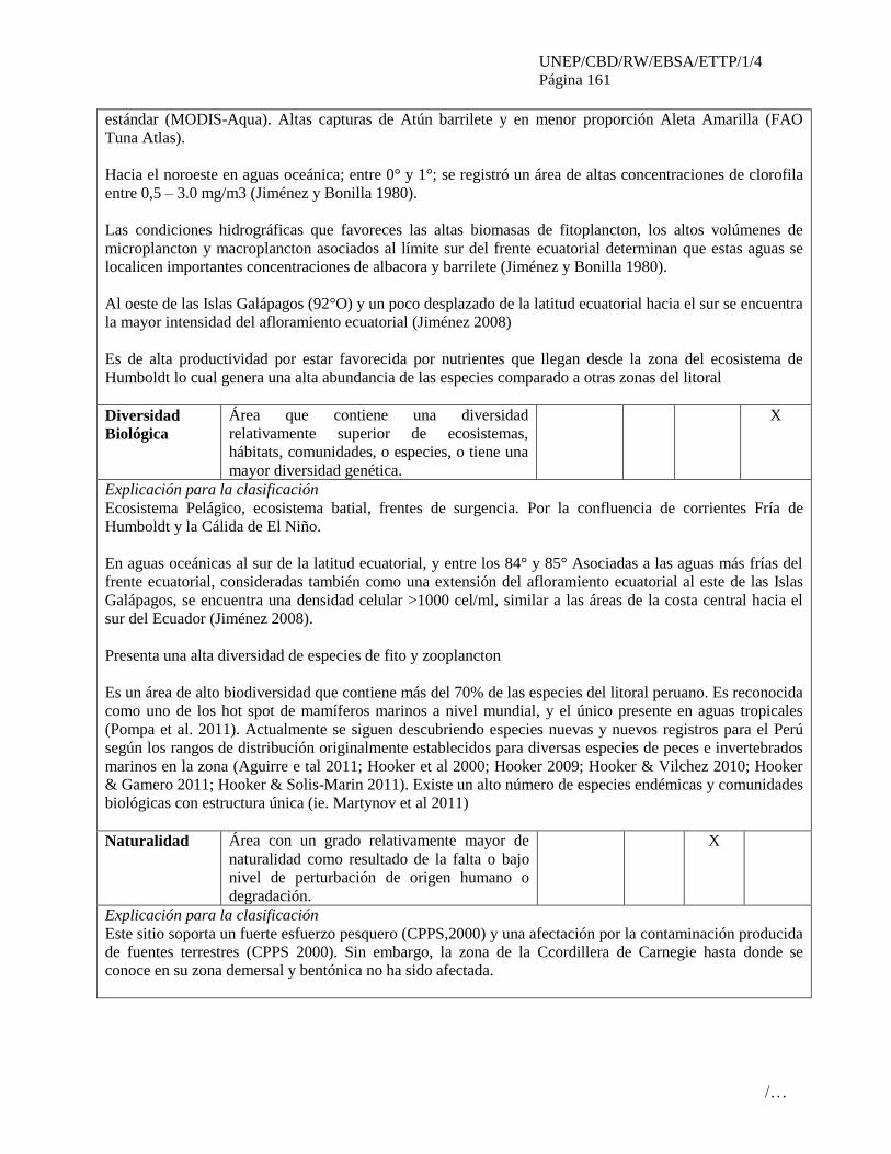
UNEP/CBD/RW/EBSA/ETTP/1/4
Página 161
/…
estándar (MODIS-Aqua). Altas capturas de Atún barrilete y en menor proporción Aleta Amarilla (FAO
Tuna Atlas).
Hacia el noroeste en aguas oceánica; entre 0° y 1°; se registró un área de altas concentraciones de clorofila
entre 0,5 – 3.0 mg/m3 (Jiménez y Bonilla 1980).
Las condiciones hidrográficas que favoreces las altas biomasas de fitoplancton, los altos volúmenes de
microplancton y macroplancton asociados al límite sur del frente ecuatorial determinan que estas aguas se
localicen importantes concentraciones de albacora y barrilete (Jiménez y Bonilla 1980).
Al oeste de las Islas Galápagos (92°O) y un poco desplazado de la latitud ecuatorial hacia el sur se encuentra
la mayor intensidad del afloramiento ecuatorial (Jiménez 2008)
Es de alta productividad por estar favorecida por nutrientes que llegan desde la zona del ecosistema de
Humboldt lo cual genera una alta abundancia de las especies comparado a otras zonas del litoral
Diversidad
Biológica
Área que contiene una diversidad
relativamente superior de ecosistemas,
hábitats, comunidades, o especies, o tiene una
mayor diversidad genética.
X
Explicación para la clasificación
Ecosistema Pelágico, ecosistema batial, frentes de surgencia. Por la confluencia de corrientes Fría de
Humboldt y la Cálida de El Niño.
En aguas oceánicas al sur de la latitud ecuatorial, y entre los 84° y 85° Asociadas a las aguas más frías del
frente ecuatorial, consideradas también como una extensión del afloramiento ecuatorial al este de las Islas
Galápagos, se encuentra una densidad celular >1000 cel/ml, similar a las áreas de la costa central hacia el
sur del Ecuador (Jiménez 2008).
Presenta una alta diversidad de especies de fito y zooplancton
Es un área de alto biodiversidad que contiene más del 70% de las especies del litoral peruano. Es reconocida
como uno de los hot spot de mamíferos marinos a nivel mundial, y el único presente en aguas tropicales
(Pompa et al. 2011). Actualmente se siguen descubriendo especies nuevas y nuevos registros para el Perú
según los rangos de distribución originalmente establecidos para diversas especies de peces e invertebrados
marinos en la zona (Aguirre e tal 2011; Hooker et al 2000; Hooker 2009; Hooker & Vilchez 2010; Hooker
& Gamero 2011; Hooker & Solis-Marin 2011). Existe un alto número de especies endémicas y comunidades
biológicas con estructura única (ie. Martynov et al 2011)
Naturalidad Área con un grado relativamente mayor de
naturalidad como resultado de la falta o bajo
nivel de perturbación de origen humano o
degradación.
X
Explicación para la clasificación
Este sitio soporta un fuerte esfuerzo pesquero (CPPS,2000) y una afectación por la contaminación producida
de fuentes terrestres (CPPS 2000). Sin embargo, la zona de la Ccordillera de Carnegie hasta donde se
conoce en su zona demersal y bentónica no ha sido afectada.
UNEP/CBD/RW/EBSA/ETTP/1/4
Página 162
/…
Referencias
Aguirre, K. L., Y. Hooker, P. Willenz and E. Hajdu. 2011. A new Clathria (Demospongiae,
Microcionidae) from Peru ocurring on rocky substrates as well as apibiotic on Eucidaris thouarsii
sea urchins. Zootaxa: 1-14.
ACAP. 2009. ACAP Species Assessment: Waved Albatross Phoebastria irrorata. Available at:
#http://www.acap.aq/acap-species/download-document/1179-waved-albatross.
Anderson, D. J.; Cruz, F. 1998. Biology and management of the Waved Albatross at the
Galápagos Islands. In: Robertson, G.; Gales, R. (ed.), Albatross biology and conservation, pp.
105-109. Surrey Beatty & Sons Pty Ltd, Chipping Norton, Australia.
Arctocephalus australis, A. galapagoensis (Carnivora: Otariidae)ou híbridos?IX Salão de
Iniciação Científica PUCRS. Sao Paulo, Brasil
BirdLife International (2012b) Important Bird Areas factsheet. Downloaded from
www.birdlife.org/datazone/site/search on 29/08/2012
BirdLife International (2012c) IUCN Red List for birds. Downloaded from
www.birdlife.org/datazone/species/search
BirdLife International. 2012a. Tracking ocean wanderers: the global distribution of albatrosses
and petrels. BirdLife International, Cambridge, U.K. www.seabirdtracking.org
Camaratta, D., de Oliveira, LR, Almeida, R., Cárdenas, S., Marquéz, JC., García, D., Bonatto, SL
. 2006. Status taxonômico dos lobos-marinhos de Isla Foca (Peru):
CPPS 2000. Estado del Ambiente Marino y Costero del Pacífico Sudeste. Elaborado por Jairo
Escobar.
CPPS/PNUMA, 2012. Atlas sobre distribución, rutas migratorias, hábitats críticos y amenazas
para grandes cetáceos en el Pacífico oriental.
Cucalón, E. 1986. Variabilidad oceanográfica frente a la costa del Ecuador durante el período
1981-1986. CPPS, Boletín Erfen 19: 11-26.
Hearn, A. Green, J. Peñaherrera, C. Acuña, D. Espinoza, E. Llerena, Y. Klimley, P.
2011. Proyecto de investigación de tiburones en la Reserva Marina de Galápagos marcaje de
tiburones ballena. Reporte Final. Galapagos Whale Shark Project - Parque Nacional Galápagos -
Universidad de California-Davis - Fundación Charles Darwin - Conservación Internacional.
Hooker, Y. 2000. Microspathodon dorsalis (Pisces: Pmacentridae) y Prionurus laticlavius
(Pisces: Acanthuridae), dos nuevos registros para el mar peruano. Informe Progresivo del Mar del
Perú 117: 1-8.
Hooker, Y. 2009. Nuevos registros de peces costeros tropicales para el Perú. Revista Peruana De
Biología 16: 33-41.
Hooker, Y. and D. Gamero. 2011. Morfología y biogeografía del coral suave Leptogorgia
peruviana (Cnidaria: Octocorallia: Gorgoniidae). II Congreso de Ciencias del Mar del Perú.
Lima, Perú.
Hooker, Y. and F. A. Solis-Marin. 2011. Tres nuevos registros de asteroideos (Echinodermata:
Asteroidea) en el Perú. Revista Peruana De Biología 18: 319-324.
Hooker, Y. and M. Vilchez. 2010. Registro en el Perú de Antipathes galapagensis Deichmann,
1941 y su simbionte Veleronia sympathes (De Ridder & Holthuis, 1979). II Congreso de Ciencias
de Mar del Perú. Lima, Perú.

UNEP/CBD/RW/EBSA/ETTP/1/4
Página 163
/…
Hooker, Y., E. Prieto-Rios and F. Solís-Marin. in press. Echinoderms of Peru. Pages 277-299 in
J. J. ALVARADO and F. A. SOLÍS-MARIN eds. Echinoderm Research and Diversity in Latin
America. Springer Berlin Heidelberg.
Hooker, Y., F. Solis-Marin and M. Lleellish. 2005. Equinodermos de las Islas Lobos de Afuera
(Lambayeque, Piura). Revista Peruana De Biología 12: 77-82.
Jiménez, R. 2008. Aspectos Biológicos de El Niño en el Océano Pacífico Ecuatorial.
Jiménez, R y D. Bonilla. 1980. Composición y Distribución de la biomasa del Plancton en el
Frente Ecuatorial. INOCAR. Acta Oceanoógrafica del Pacífico 1(1).
Llapapasca etal. 2012. Persistencia en el patrón de distribución temporal de la Ballena Jorobada
(Megaptera novaeangliae) en la costa norte del Perú. Conferencia de Ciencia del Mar III. 19-26
de Junio, 2012. Lima, Perú.
Martynov, A., B. Brenzinger, Y. Hooker and M. Schrodl. 2010. 3d-Anatomy of a new tropical
peruvian nudibranch gastropod species, Corambe mancorensis, and novel hypotheses on dorid
gill ontogeny and evolution. Journal of Molluscan Studies 77: 129-141.
Nolasco etal. 2012 El Ñuro (Perú), hábitat crítico de la tortuga verde del Pacífico oriental.
Conferencia de Ciencia del Mar III. 19-26 de Junio, 2012. Lima, Perú.
PAT- EC Grupo Tiburón. 2011. Estudio de Caso: TIBURONES MARTILLO Sphyrna lewini
(Griffith y Smith, 1834) y S. zygaena (Linnaeus, 1758) BIOLOGÍA, PESQUERÍA Y
CONSIDERACIONES PARA SU CONSERVACIÓN Y MANEJO EN EL ECUADOR / CASE
STUDY: Hammerhead Shark Sphyrna lewini (Griffith and Smith, 1834) and S. zygaena
(Linnaeus, 1758) BIOLOGY, AND CONSIDERATIONS FOR FISHERY CONSERVATION
AND MANAGEMENT IN ECUADOR. Subsecretaría de Recursos Pesqueros (SRP) - Ministerio
de Agricultura, Ganadería, Acuacultura y Pesca (MAGAP). 43 pp.
Pompa, S., P. R. Ehrlich and G. Ceballos. 2011. Global distribution and conservation of marine
mammals. PNAS 108: 13600-13605.
Shillinger, G L, D M Palacios, H Bailey, S J Bograd, A M Swithenbank, P Gaspar, B P Wallace,
et al. 2008. “Persistent Leatherback Turtle Migrations Present Opportunities for Conservation.”
PLoS Biology6 (7): e171. doi:doi:10.1371/journal.pbio.0060171
SIBIMAP, 2012. http://cpps.dyndns.info/sibimap/cetaceos.html
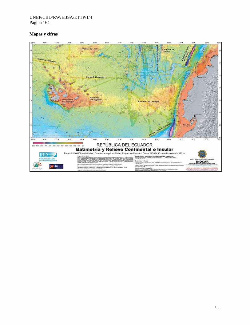
UNEP/CBD/RW/EBSA/ETTP/1/4
Página 164
/…
Mapas y cifras
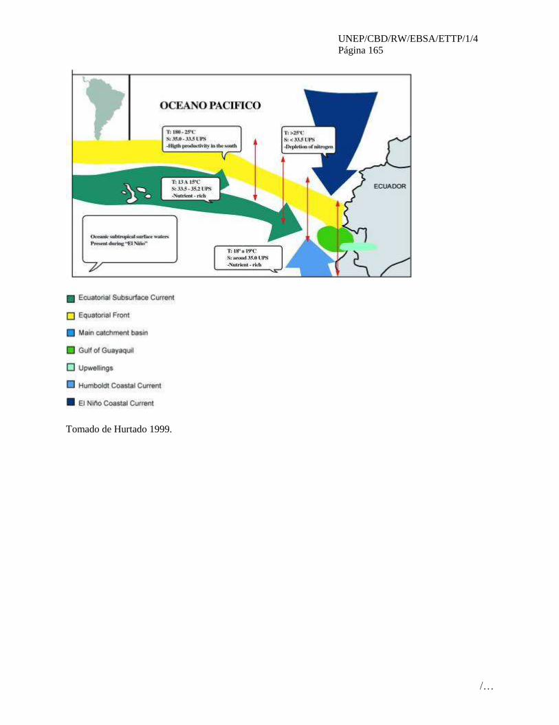
UNEP/CBD/RW/EBSA/ETTP/1/4
Página 165
/…
Tomado de Hurtado 1999.

UNEP/CBD/RW/EBSA/ETTP/1/4
Página 166
/…
Zonas de ocurrencia de Cachuda Blanca (Sphyrna zigaena) (fuente PAT-EC 2011)

UNEP/CBD/RW/EBSA/ETTP/1/4
Página 167
/…
Fuente: Tomado de Jiménez 2008
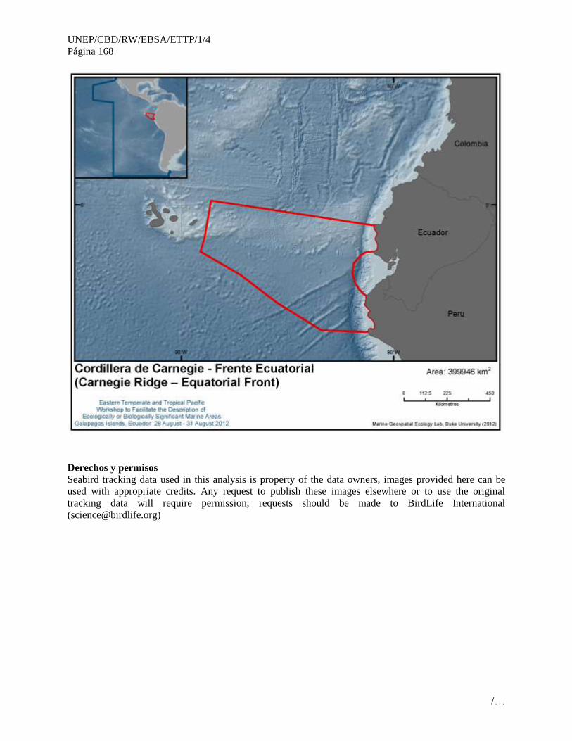
UNEP/CBD/RW/EBSA/ETTP/1/4
Página 168
/…
Derechos y permisos
Seabird tracking data used in this analysis is property of the data owners, images provided here can be
used with appropriate credits. Any request to publish these images elsewhere or to use the original
tracking data will require permission; requests should be made to BirdLife International
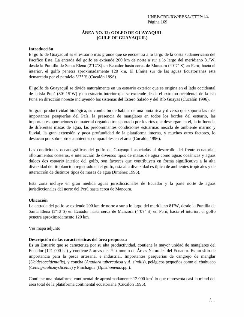
UNEP/CBD/RW/EBSA/ETTP/1/4
Página 169
/…
ÁREA NO. 12: GOLFO DE GUAYAQUIL
(GULF OF GUAYAQUIL)
Introducción
El golfo de Guayaquil es el estuario más grande que se encuentra a lo largo de la costa sudamericana del
Pacífico Este. La entrada del golfo se extiende 200 km de norte a sur a lo largo del meridiano 81ºW,
desde la Puntilla de Santa Elena (2º12’S) en Ecuador hasta cerca de Mancora (4º07’ S) en Perú; hacia el
interior, el golfo penetra aproximadamente 120 km. El Límite sur de las aguas Ecuatorianas esta
demarcado por el paralelo 3º23’S (Cucalón 1996).
El golfo de Guayaquil se divide naturalmente en un estuario exterior que se origina en el lado occidental
de la isla Puná (80º 15´W) y un estuario interior que se extiende desde el extremo occidental de la isla
Puná en dirección noreste incluyendo los sistemas del Estero Salado y del Río Guayas (Cucalón 1996).
Su gran productividad biológica, su condición de hábitat de una biota rica y diversa que soporta las más
importantes pesquerías del País, la presencia de manglares en todos los bordes del estuario, las
importantes aportaciones de material orgánico transportado por los ríos que descargan en el, la influencia
de diferentes masas de agua, las predominantes condiciones estuarinas mezcla de ambiente marino y
fluvial, la gran extensión y poca profundidad de la plataforma interna, y muchos otros factores, lo
destacan por sobre otros ambientes comparables en el área (Cucalón 1996).
Las condiciones oceanográficas del golfo de Guayaquil asociadas al desarrollo del frente ecuatorial,
afloramientos costeros, e interacción de diversos tipos de masas de agua como aguas oceánicas y aguas
dulces des estuario interior del golfo, son factores que contribuyen en forma significativa a la alta
diversidad de fitoplancton registrado en el golfo, esta alta diversidad es típica de ambientes tropicales y de
interacción de distintos tipos de masas de agua (Jiménez 1996).
Esta zona incluye en gran medida aguas jurisdiccionales de Ecuador y la parte norte de aguas
jurisdiccionales del norte del Perú hasta cerca de Mancora.
Ubicación
La entrada del golfo se extiende 200 km de norte a sur a lo largo del meridiano 81ºW, desde la Puntilla de
Santa Elena (2º12’S) en Ecuador hasta cerca de Mancora (4º07’ S) en Perú; hacia el interior, el golfo
penetra aproximadamente 120 km.
Ver mapa adjunto
Descripción de las características del área propuesta
Es un Estuario que se caracteriza por su alta productividad, contiene la mayor unidad de manglares del
Ecuador (121 000 ha) y contiene 5 áreas del Patrimonio de Áreas Naturales del Ecuador. Es un sitio de
importancia para la pesca artesanal e industrial. Importantes pesquerías de cangrejo de manglar
(Ucidesoccidentalis), y concha (Anadara tuberculosa y A. similis), pelágicos pequeños como el chuhueco
(Cetengraulismysticetus) y Pinchagua (Opisthonemaspp.).
Contiene una plataforma continental de aproximadamente 12.000 km2 lo que representa casi la mitad del
área total de la plataforma continental ecuatoriana (Cucalón 1996).
UNEP/CBD/RW/EBSA/ETTP/1/4
Página 170
/…
La profundidad es variable desde 180m en el borde exterior hasta menos de 20m en la parte interior
(Stevenson 1981).
Presenta islas de gran importancia como Puná de 25 km de ancho y una superficie de 919 km2 y la isla
Santa Clara de aproximadamente 1.6 km y una superficie de 45ha.
Climatología: Esta localizado en una región de clima tropical que exhibe marcadas variaciones
estacionales. Durante el periodo de junio a noviembre se registra la estación seca y durante enero a abril
la estación lluviosa. Se caracteriza por registrar precipitaciones acumuladas de cerca de 900mm durante
los meses de enero a mayo. La temperatura media del aire es de unos 26ºC en la estación lluviosa y de
23ºC en la estación seca. Aunque también se muestra una variación espacial: en Ancón (localizada al
norte) se registran precipitaciones anuales de 154 mm, mientras que en Puerto Bolívar al sur se registran
475mm.
Los vientos predominantes varían estacionalmente: durante la estación seca, los vientos soplan
predominantemente del oeste con velocidades promedio de 6 m/s y forman parte del sistema de vientos
alisios. En la época lluviosa la dirección de los vientos puede fluctuar dentro de un amplio rango que va
desde sureste hasta oeste (INOCAR 1992).
En el golfo descargan 23 cuencas hidrográficas que abarcan una superficie total de 50489 km2. En la que
destaca la Cuenca del Río Guayas que constituye el sistema fluvial más importante de toda la vertiente
occidental de los Andes. Es el más grande de la costa occidental de Sudamérica. En la estación seca el
caudal promedio es de cerca 230m3/s y en la estación lluviosa se incrementa hasta 1 500m3/s (Osorio
1984).
Temperatura del agua: presenta una marcada variación espacial y temporal en la estación seca: entre 25ºC
en el interior hasta 21ºC en el exterior. En la estación lluviosa desde 28ºC hasta 25ºC (Stevenson 1981).
Salinidad: Presenta notables variaciones de salinidad que va desde 34-35 UPS hasta 29-30UPS en la
estación seca. En la estación de lluvias se reduce desde 33.5-34.5 UPS hasta cerca de 20 UPS (Stevenson
1981).
Profundidad de la capa de mezcla: en la época seca es de 20 m en la entrada del golfo y se reduce hasta 5
m al oeste de la isla Puná. Mientras que en la estación lluviosa se mantiene en alrededor de 5m en gran
parte del estuario exterior (Stevenson 1981).
Este estuario ha sido clasificado como Parcialmente Mezclado (Tipo 2b) en la clasificación de Hansen y
Rattray (Murray et al. 1975). Este tipo de estuarios se caracteriza por un flujo neto que invierte su sentido
con la profundidad y porque tanto procesos advectivos como difusivos son importantes para el flujo neto
de sal río arriba (Cucalón 1996). Tiene un tiempo de renovación (flushing time) estimado en 21 días
(Murray et al 1975) y entre 13 y 8 días (Palacios 1989).
Presenta grandes interacciones con las masas de agua oceánicas presentes en el exterior del golfo.
Existen 7 áreas protegidas dentro de zona; 6 presentes en Ecuador: Reserva Ecológica Manglares
Churute, Refugio de Vida Silvestre isla Santa Clara, Reserva de Producción de Fauna Manglares El
Salado, Refugio de Vida Silvestre Manglares El Morro, Reserva de Producción de Fauna Península de

UNEP/CBD/RW/EBSA/ETTP/1/4
Página 171
/…
Santa Elena, Área Nacional de Recreación Playas de Villamil (MAE 2012); y, una presente en territorio
peruano: Santuario Nacional Los Manglares de Tumbes (SERMANP 2012).
Biología:
Bacterioplancton: 15 especies (Barniol y Machuca 1997)
Fitoplancton: 456 especies (Jiménez 1996).
Zooplancton: Tintinidos 50 especies (Tazán 1965; Zambrano 1983), 18 especies de Quetognatos (Bonilla
1983), Pteropodos 5 especies (Cruz 1983), 12 especies de foraminíferos plactónicos (Peribonio et al
1981), 40 especies de copépodos (Arcos 1978).
También se ha identificado el golfo de Guayaquil como el lugar de mayor abundancia de huevos y larvas
de peces (Jimenez y Bonilla 1978); en 1981 se realizó un análisis especialmente de clupeidos(sardinas) y
engraulidos (anchovetas)(Cajas e Hinostroza1981) y se ha registrado hasta10 000 huevos/m2 y 10 000
larvas/m2 en la zona (Villamar y Ortega 1991).
Es una importante zona para los estadios larvales y juveniles de los camarones litopeneidos con
densidades reportadas de hasta 500 larvas/m2 de arrastre a pesar de ser realizadas en un año (1986)
considerado como atípico por la falta de postlarva (Luzuriaga de Cruz 1989).
Macroinvertebrados: 97 especies de foraminíferos bentónicos (Gualancañay 1983), 37 sp. De poliquetos
(Villamar 1983); y 75 sp. de moluscos (Cruz 1980).
Existen además importantes poblaciones de especies de interés comercial como el cangrejo rojo de
manglar (Ucidesoccidentalis) se extraen aproximadamente 5.1 millones de unidades por año (INP 2011a),
Ostiones (Ostreacolumbiensis) con densidades de hasta 85.9 ind/m2 (Mora y Reinoso 1981) y Conchas
(Anadarasimilis y tuberculosa) donde se extrae un promedio de 5.7 millones de unidades por año (INP
2011b).
Pesquerías:
Peces Pelágicos pequeños: Las áreas de mayores capturas se encuentran en la parte exterior del golfo de
Guayaquil (Coello 1996; Gonzales et al 2007) y el principal puerto de desembarque es Posorja.
Peces Pelágicos Grandes: El golfo de Guayaquil es una de las áreas de pesca más importantes para la
captura sobre objetos flotantes y brisas (Coello 1996).
Es una zona rica en pesca demersal con densidades de peces de hasta 9.6 TM/km2 (Herdson 1985)
Condición de las características y perspectivas a futuro de la zona propuesta
Esta zona se ha realizado mucha investigación especialmente por el Instituto Nacional de Pesca y el
Instituto Oceanográfico de la Armada, El golfo de Guayaquil es considerada como un “área de interés” en
el Plan Ambiental Ecuatoriano (CAAM 1996b) y ha sido y es objeto de mucho interés por la importancia
económica, social y ambiental que representa para nuestro país.
Mientras por un lado se ha detenido la deforestación de manglar e incluso se está recuperando, el tema de
la contaminación continúa, así como la sobrexplotación de los recursos pesqueros.

UNEP/CBD/RW/EBSA/ETTP/1/4
Página 172
/…
Evaluación del área sobre los criterios EBSA del CDB
Criterios
CBD EBSA
(Anexo I de la
decisión IX/20)
Descripción
(Anexo I de la decisión IX/20) Clasificación de los criterios
pertinentes
No lo se Bajo Alguno Alto
Características
únicas, rarezas
Área de singularidad o rareza contiene ya sea
(i) exclusivas («la única de su clase"), raras
(sólo ocurre en pocos lugares) o de especies
endémicas, poblaciones o comunidades, y / o
(ii) único, raro o distinto, los hábitats o los
ecosistemas, y / o (iii) características
geomorfológicos u oceanográficos exclusivos
o desacostumbrados.
X
Explicación para la clasificación
Es el estuario más importante de la costa del Pacifico Sudeste (Stevenson 1981). Incluye 121 000 ha de
manglar que representa el 81% de todo el manglar del Ecuador Continental, en su interior se encuentran 7
áreas protegidas,6 presentes en Ecuador: Reserva Ecológica Manglares Churute, Refugio de Vida Silvestre
isla Santa Clara, Reserva de Producción de Fauna Manglares El Salado, Refugio de Vida Silvestre
Manglares El Morro, Reserva de Producción de Fauna Península de Santa Elena, Área Nacional de
Recreación Playas de Villamil (MAE 2012); y, una presente en territorio peruano: Santuario Nacional Los
Manglares de Tumbes (SERMANP 2012).
Importancia
especial para
las etapas del
ciclo biológico
de especies
Las áreas requieren una población para
sobrevivir y prosperar.
X
Explicación para la clasificación
El golfo de Guayaquil y en especial los manglares que contiene es una importante zona de reproducción y
nursery de especies bioacuáticas (por ejemplo camarones Litopenaeusvannamei). Es también hábitat para la
única colonia residente de bufeos (Tursiopstruncatus)(Felix 1997) y los alrededores de la isla Santa Clara
también se ha identificado como sitio de reproducción de ballenas jorobada (Hurtado et al 1997).
Adicionalmente se han identificado 2 sitios de importancia para la reproducción de las aves marinas: Santa
Clara y El Morro que albergan importantes colonias de Fragata, Piqueros Patas Azules y Pelicanos pardos
(MAE 2007; Hurtado 1997, Birdlife 2012).
The Waved Albatross (Phoebastriairrorata) is an Ecuadorian endemic breeder. Isla Espanola, Galapagos
holds 99% of the world population, estimated most recently as 9,607 pairs in 2001, with an additional 5,495
breeding adults not nesting (ACAP, 2009). Albatross nesting on Espanola have been studied using satellite
tracking devices during the incubation period, and have been found to feed in this area between April and
August (Anderson and Cruz 1998). More than 3000 individuals may feed in the area, potentially a third of
the global population (BirdLife International 2012a).
The Parkinson’s Petrel (Procellariaparkinsoni), an endemic breeder to New Zealand, has been studied using
satellite tracking devices from its main colony on Great Barrier Island. Tracking data shows the birds
migrate across the Pacific Ocean to feed in this area during its non-breeding season between May and
September (Bell et al, 2009). With 1-2000 individuals thought to be present in the area, equating to close to
half the world population (BirdLife International 2012a).
Isla Santa Clara holds several breeding seabird species that occur in globally significant numbers, with the
site qualifying as an Important Bird Area (IBA) under BirdLife International criteria. The area includes the
UNEP/CBD/RW/EBSA/ETTP/1/4
Página 173
/…
key foraging areas around the island for four species, the Defelippi’s petrel (Pterodromadefilippiana), Blue-
footed booby (Sula nebouxii), Brown Pelican (Pelecanusoccidentalis) and Magnificent Frigatebird
(Fregatamagnificens) (BirdLife International 2012b).
Importancia de
especies
amenazadas, en
peligro o en
declive y/o
hábitats
Áreas que contienen hábitat para la
supervivencia y recuperación de especies en
peligro, amenazadas, especies en declive o
área con agrupamientos significativos de tales
especies.
X
Explicación para la clasificación
Es parte del área de reproducción de la ballena jorobada (Megapteranovaeangliae) del Pacífico Sudeste
(CPPS/PNUMA, 2012). E incluye las IBAS EC030 y EC031 (Birdlife 2005). Se han reportado tres especies
de aves amenazadas (Granizo et al., 2002); que corresponden a 1 especie en peligro de extinción, gallinita de
mangle o rascón montés cuellirufoAramidesaxillaris EN (B1+2ABC); y, 2 especies vulnerables, el gavilán
manglero Buteogallusanthracinus VU (B1+2ABC) y el perico cachetigrísBrotogerispyrrhopterus VU
(B1+2ABC). Así como un importante hábitat para los Albatros de Galápagos CR.
The Waved Albatross is listed as Critically endangered on the IUCN Red List; It is an endemic breeder to
Ecuador and the Galapagos. Espanola in the Galapagos is the main breeding site, with small number also
found on isla de la Plata on the Ecuadorian coast. BirdLife International (2012c)Defelippi’s Petrel is listed
as Vulnerable. BirdLife International (2012c)Parkinson’s Petrel is listed as Vulnerable BirdLife
International (2012c)
Vulnerabilidad,
fragilidad,
sensibilidad, o
Áreas de lenta
recuperación
Áreas que contengan una proporción
relativamente elevada de hábitats sensibles,
biotopos o especies que son funcionalmente
frágiles (altamente susceptibles a la
degradación o agotamiento por actividades
humanas o por acontecimientos naturales) o
con una lenta recuperación.
X
Explicación para la clasificación
Presenta una alta vulnerabilidad por el efecto de Eventos ENSO, especialmente las colonias reproductoras
de aves marinas presentan grandes mortalidades (Hurtado et al. 1998), existe sobrepesca de recursos
marinos y es una importante zona de Tráfico Marítimo ya que se encuentra el principal Puerto del Ecuador.
Los manglares fueron fuertemente afectados y transformados en camaroneras especialmente en la década de
los 80s (Clirsen 2007). Asi como importante afectación por contaminación de fuentes terrestres
especialmente hidrocarburos y metales pesados (CPPS 1998).
All seabirds are long lived (several decades) and slow at reproducing (normally 1 chick a year, and often
taking several years to reach maturity) making them vulnerable and slow to recover following declines.
Productividad
biológica
Área que contiene especies, poblaciones o
comunidades con relativamente mayor
productividad biológica natural.
X
Explicación para la clasificación
El golfo de Guayaquil reporta una productividad expresada en Clorofila a de 0,5 a 4 mg/m3 (Jimenez y
Bonilla 1980).
Se ha descrito como el principal estuario del Pacífico Sudeste, componente hidrográfico de alta
productividad biológica (Stevenson 1981). Lo que sustenta importantes pesquerías especialmente de peces
UNEP/CBD/RW/EBSA/ETTP/1/4
Página 174
/…
pelágicos pequeños (Gonzales et al 2007).
La productividad neta superficial (método evolución de oxígeno) tiene un promedio anual de 401
mgC/m2/día en el estuario interior y de 98 mgC/m2/día en el estuario interior. Así mismo se ha estimado
que la productividad neta de la columna de agua se encuentra en el estuario exterior y es de 800
mgC/m2/día. En 1973 se registró la mayor productividad en superficie de 760 mgC/m2/día (método C14)
(Jiménez y Pesante 1978).
Diversidad
Biológica
Área que contiene una diversidad
relativamente superior de ecosistemas,
hábitats, comunidades, o especies, o tiene una
mayor diversidad genética.
X
Explicación para la clasificación
Se ha reportado: Fitoplancton: 456 especies (Jiménez 1996).
Se han identificado 80 especies de aves marinas, costeras y terrestres, especialmente en las zonas de
manglares.
Naturalidad Área con un grado relativamente mayor de
naturalidad como resultado de la falta o bajo
nivel de perturbación de origen humano o
degradación.
X
Explicación para la clasificación
Este sitio soporta un importante esfuerzo pesquero y una afectación por la contaminación producida de
fuentes terrestres (CPPS 2000) sobre todo urbanas especialmente en lo que tiene que ver con Demanda
Química y Demanda Bioquímica de Oxígeno, nutrientes, coliformes totales y fecales, presencia de Cadmio
y Cromo en agua (CPPS 2000). Existen todavía zonas relativamente intocadas pero son muy pocas.
Referencias
ACAP. 2009. ACAP SpeciesAssessment: WavedAlbatrossPhoebastriairrorata. Available at:
www.acap.aq/acap-species/download-document/1179-waved-albatross.
Anderson, D. J.; Cruz, F. 1998.Biology and management of the Waved Albatross at the
Galápagos Islands. In: Robertson, G.; Gales, R. (ed.), Albatross biology and conservation, pp.
105-109. Surrey Beatty & Sons Pty Ltd, Chipping Norton, Australia.
Arcos, F. 1978. Distribución de la biomasa planctonica y copépodos en la parte interior del golfo
de Guayaquil. Revista Ciencias del Mar y Limnología. Vol 3(1). Pag 129-134.
Bell, E. A.; Sim, J. L.; Scofield, P. 2009. Populationparameters and distribution of theBlack
Petrel (Procellariaparkinsoni), 2005/06. Department of Conservation, Wellington, N.Z.
BirdLife International (2012b) Important Bird Areas factsheet. Downloaded from
www.birdlife.org/datazone/site/search on 29/08/2012
BirdLife International (2012c) IUCN Red List for birds. Downloaded from
www.birdlife.org/datazone/species/search
BirdLife International. 2012a. Tracking ocean wanderers: the global distribution of albatrosses
and petrels. BirdLife International, Cambridge, U.K. www.seabirdtracking.org
BirdLife International.2012b. Important Bird Areas factsheet: Isla Santa Clara. Downloaded
from http://www.birdlife.org on 14/09/2012.
BirdLife International. 2012b. Important Bird Areas factsheet: Manglares del golfo de Guayaquil.
Downloaded from http://www.birdlife.org on 14/09/2012
UNEP/CBD/RW/EBSA/ETTP/1/4
Página 175
/…
Bonilla, D. 1983. Estudio Taxonómico de los Quetognatos del golfo de Guayaquil. INOCAR. Vol
2(2).
CAAM 1995. Plan ambiental Ecuatoriano.
CAAM. 1996. Desarrollo y Problemática ambiental del área del golfo de Guayaquil. Comisión
Asesora Ambiental, Quito.
Cajas; L. dey D. Hinostroza. 1981. Huevos y Larvas de clupeídos y engráulidos en el golfo de
Guayaquil. Revista Ciencias del Mar y LimnologíaVol 1(1).
CLIRSEN 2007. ACTUALIZACIÓN DEL ESTUDIO MULTITEMPORAL DE MANGLARES,
CAMARONERAS Y ÁREAS SALINAS EN LA COSTA CONTINENTAL ECUATORIANA
AL AÑO 2006. Elaborado para el PMRC
CPPS 2000. Estado del Ambiente Marino y Costero del Pacífico Sudeste. Elaborado por Jairo
Escobar.
CPPS/PNUMA, 2012. Atlas sobre distribución, rutas migratorias, hábitats críticos y amenazas
para grandes cetáceos en el Pacífico oriental.
Cucalón, E. 1996. Oceanografía y Sistemas Físicos en el golfo de Guayaquil. En: Sistemas
Biofísicos en el golfo de Guayaquil. CAAM. 1-109.
De Barniol, L. y M. Machuca.1997. Estudio sobre el bacterioplancton durante y después de la
prospección sísmica en el Campo Amistad, golfo de Guayaquil, en julio-agosto de 1997. Inf. Téc.
ACUATECNOS
Félix, F. 1997. Organization and social structure of the bottlenose dolphin Tursiopstruncatus in
the Gulf of Guayaquil, Ecuador. Aquatic Mammals, 23 (1):1-16.
Gonzales, N., M Prado, R Castro, F Solano, V Jurado, y M Peña. ANÁLISIS DE LA
PESQUERÍA DE PECESPELÁGICOS PEQUEÑOS EN EL ECUADOR(1981-2007). Instituto
Nacional de Pesca Ecuador.
Herdson, D., W.T. Rodríguez and J. Martinez.1985. The Demersal Fish resources of the
continental shelf of Ecuador, part one. Distributions, abundance and recommended utilization of
white fish resources in Ecuador.Boletín Científico Técnico Vol VIII (5). Instituto Nacional de
Pesca, Ecuador.
INOCAR 1992. Atlas meteorológico del mar ecuatoriano. 1971-1991.
INP. 2011a. DESEMBARQUES DE CANGREJO EN PUERTO DE LA PROVINCIA DEL
GUAYAS Y EL ORO. Instituto Nacional de Pesca.
INP. 2011b. DESEMBARQUES DEL RECURSO CONCHA (Anadara tuberculosa y A. similis).
Instituto Nacional de Pesca.
Jiménez, R. 2008. Aspectos Biológicos de El Niño en el Océano Pacífico Ecuatorial.
Jiménez, R y D. Bonilla. 1980. Composición y Distribución de la biomasa del Plancton en el
Frente Ecuatorial. INOCAR. Acta Oceanográfica del Pacífico 1(1).
Jiménez, R. y F. Pesantes. 1978. Fitoplancton, producción primaria y pigmentos en aguas costeras
ecuatorianas. INOCAR Vol 2(1).
Luzuriaga de Cruz, M. 1989. Crustáceos zooplanctonicos y materia orgánica en manglares del
golfo de Guayaquil. Revista Comisión Permanente Pacífico Sur. Número Especial.
MAE. 2012. Áreas protegidas del Ecuador.
Ministerio del Ambiente del Ecuador. 2010. Plan de Manejo del Refugio de Vida Silvestre
Manglares El Morro.Fundación Ecuatoriana para el Estudio de Mamíferos Marinos (FEMM),
Fundación Natura y Conservación Internacional Ecuador. General Villamil, Ecuador

UNEP/CBD/RW/EBSA/ETTP/1/4
Página 176
/…
Mora, E. y B. Reinoso. 1981. Investigaciones preliminares sobre el estado actual de las
poblaciones de ostiones en tres zonas del estuario interior del golfo de Guayaquil. Revista
Ciencias del Mar y LimnologíaVol 1(1).
Murray, S., D. Conlon, A. Siripong. Y J. Santoro. 1975. Circulation and salinity distribution in
the Río Guayas estuary, Ecuador. EstuarineResearch, Vol II, AcademicPressm NY.
Osorio, V. 1984. Características de la variación de la salinidad del estuario interior del Río
Guayas en relación a la descarga de los ríos Daule y Babahoyo y a la acción de las mareas. Tesis
de Grado ESPOL.
PATRA. 1998. “Evaluación Ambiental del Campo Amistad y de la Isla Santa Clara en el golfo de
Guayaquil”. Eds. Mario Hurtado y Johnny Chavarría. Convenios: Ministerio de MedioAmbiente
(MMA) y EDC - Ecuador Ltd.; MMA - INOCAR; MMA - INP.
Palacios, P. 1989. Determinación del Prisma de marea y tiempo de renovación de los sistemas
Río Guayas- Canal de Jambelí y Estero Salado- Canal del Morro.
Peribonio, R. de. 1981. Distribución de clorofila a y feopigmentos en el golfo de Guayaquil.
Revista Ciencias del Mar y LimnologíaVol 1(1).
Rodríguez de Tazán. G. 1965. Estudio Taxonómico-Ecológico de los Tintinnidos del Plancton del
golfo de Guayaquil. Tesis.
SERMANP 2012. Santuario Nacional Los Manglares de Tumbes.
http://www.sernanp.gob.pe/sernanp/zonaturismoi.jsp?ID=42
Stevenson, M. 1981. Variaciones estacionales en el golfo de Guayaquil, un estuario tropical.
Boletín Científico Técnico VolIV (1).
Villamar, F. y D. Ortega. 1991. Estudio de huevos y larvas de peces en el mar ecuatoriano
durante septiembre-diciembre de 1990. Boletín Científico Técnico Vol 11(1).
Zambrano, I. 1983. Tintinidos del golfo de Guayaquil. INOCAR Vol 2(2).

UNEP/CBD/RW/EBSA/ETTP/1/4
Página 177
/…
Mapas y cifras
Ubicación del golfo de Guayaquil

UNEP/CBD/RW/EBSA/ETTP/1/4
Página 178
/…
Capturas de Pinchagua en el golfo de Guayaquil (Gonzalez et al 2007)
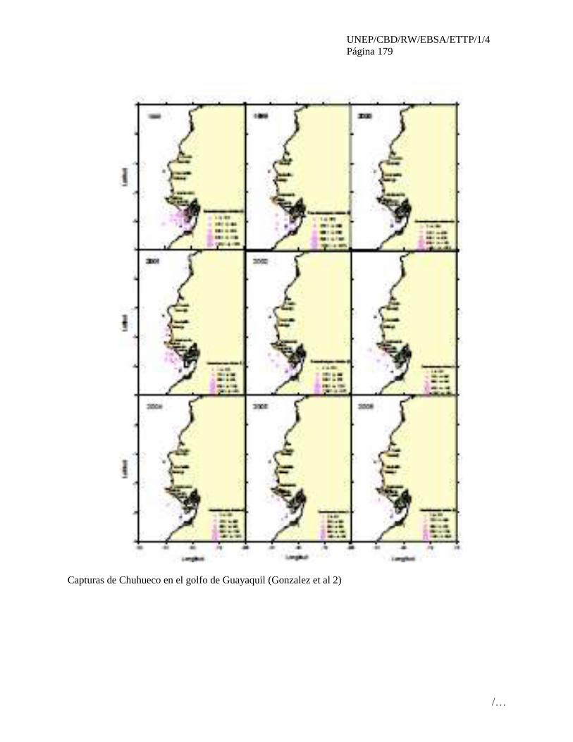
UNEP/CBD/RW/EBSA/ETTP/1/4
Página 179
/…
Capturas de Chuhueco en el golfo de Guayaquil (Gonzalez et al 2)

UNEP/CBD/RW/EBSA/ETTP/1/4
Página 180
/…
Derechos y permisos
Seabird tracking data used in this analysis is property of the data owners, images provided here can be
used with appropriate credits. Any request to publish these images elsewhere or to use the original
tracking data will require permission; requests should be made to BirdLife International
UNEP/CBD/RW/EBSA/ETTP/1/4
Página 181
/…
ÁREA NO. 13: SISTEMA DE SURGENCIA DE LA CORRIENTE HUMBOLDT EN PERÚ
(HUMBOLDT CURRENT UPWELLING SYSTEM IN PERU)
Resumen
El ecosistema de Humboldt frente al Perú (entre 5 y 18° S) es una de las zonas marinas más productivas
del mundo, asociada a un activo sistema de afloramiento marino-costero, exclusivo por su alto
endemismo. Esta zona se caracteriza por los patrones de vientos paralelos a la costa, que empujan las
aguas superficiales, permitiendo el afloramiento de aguas profundas ricas en nutrientes hacia la capa
fótica. Estas zonas están caracterizadas por albergar abundantes poblaciones de pequeños peces pelágicos
(anchovetas y sardinas) que a su vez alimentan grandes poblaciones de depredadores y actividades
pesqueras. Existen siete focos de afloramiento intenso de alta importancia para el reestablecimiento del
sistema después de eventos de alta variabilidad climática. A demás alberga una biodiversidad de
importancia global, lo que lo ha llevado a ser nominado como una de las 200 ecoregiones prioritarias de
conservación a nivel global. Adicionalmente, una variedad de actividades antropogénicas ejercen presión
sobre este ecosistema único.
Introducción
Los sistemas de corriente de borde oriental son reconocidos a nivel mundial por su alta productividad
biológica que se basa esencialmente en producción primaria nueva (Mann & Lazier, 1992), producto de
un alto flujo de nutrientes inducido por el proceso de surgencia costera. Estas regiones se les reconocen
como los grandes ecosistemas marinos (LME; Sherman et al 1995). Entre ellos, en la región norte de
Humboldt la surgencia se deriva de un régimen de vientos paralelos a la costa, que entregan energía a la
capa superficial del mar dando lugar a un transporte de agua costa afuera y permitiendo el ascenso de
aguas ecuatoriales subsuperficiales frías, ricas en nutrientes y con bajo contenido de oxígeno. La
fertilización de la capa fótica por parte de la surgencia, junto con el ascenso de aguas hipóxicas generan
un sistema único del punto de vista biogeoquímico, y que sustenta la mayor pesquería mundial de
recursos pelágicos.
Sistema de afloramiento costero de la Corriente de Humboldt frente a la costa de Perú posee una alta
variabilidad ambiental, forzada por la dinámica ecuatorial y local, además de la variabilidad climática
decadal, multidecadal (Chávez et al., 2003) y posiblemente el cambio climático global (Bakun & Weeks,
2010). Este sistema está muy afecto a la ciclicidad de ENOS (El Niño Oscilación del Sur) y su estructura
y funcionamiento pueden ser fuertemente impactados por fenómeno irregulares de El Niño, aunque su
alta capacidad de recuperación lo caracteriza como un ecosistema de mucha resiliencia (Chávez &
Messié, 2009).
Este sistema, por sus características, constituye un ecosistema único de la Corriente de Humboldt y del
Océano Pacífico, distintivo por su altísima producción biológica, alta producción de biomasa de peces,
altos flujos de carbono (C), complejas tramas trófica, y comunidades especiales de alta diversidad. La
singularidad e importancia ecológica de este ecosistema proveen suficientes fundamentos para sugerirlo
como un área de alta significancia ecológica y biológica del océano mundial.
Ubicación
Esta región se localiza en la zona costera del ecosistema de la Corriente de Humboldt, frente a la costa
central del Perú entre latitud 5 y 18°S. El límite oeste se extiende desde la línea de la costa hacía el límite
externo del talúd continental, el cuál alcanza una isóbata de aproximadamente 5,000m.

UNEP/CBD/RW/EBSA/ETTP/1/4
Página 182
/…
Descripción de las características del área propuesta
El sistema de afloramiento costero de la Corriente de Humboldt frente a la costa de Perú es una región
costera, caracterizada por una surgencia muy intensa y alta concentración
de fitoplancton en toda la franja entre la costa y los 100 km afuera de la
costa (Fig. 1).
La columna de agua está dominada por una fuerte estratificación vertical
y un marcado gradiente de oxígeno en los primeros 50 m, La oxiclina se
manifiesta en el rango de 10 a 50 m y en su base se encuentra el límite
superior de la zona de mínimo de oxígeno (ZMO). La presencia somera
de la ZMO restringe el hábitat vertical del plancton que depende de aguas
oxigenadas, favoreciendo una fuerte agregación vertical del fitoplancton,
zooplancton y peces pequeños pelágicos . Tal agregación puede acelerar
la transferencia de C entre los distintos niveles tróficos, dando origen a
un sistema altamente eficiente para la producción de peces y otros niveles
tróficos. Esta particularidad los distingue claramente de otros ecosistemas
de surgencia costera, en términos de mayor producción pesquera
comparativa (Kudela, 2005; Chávez & Messié, 2009).
La presencia de fuertes gradientes verticales ha dado origen a
comunidades muy especiales que se han adaptado a aguas
hipóxicas/anóxicas y han permitido la evolución de variadas estrategias
adaptativas para ajustarse a estos ambientes. Es así como muchas
especies epipelágicas del plancton y peces evaden la ZMO restringiendo sus distribuciones verticales
(Bertrand et al., 2010), pero otras pueden ingresar temporalmente a la ZMO (Hidalgo et al., 2005), u otras
incluso atravesar la ZMO, tales como los eufáusidos y peces mictófidos. La presencia de la ZMO por otra
parte constituye un relicto del océano ancestral de la tierra y por lo tanto puede manifestar comunidades
microbianas muy peculiares de metabolismo anaeróbico.
La presencia de una ZMO somera se manifiesta también en el sistema bentónico, caracterizado
por una rica comunidad microbiana anaeróbica y bajo nivel de oxidación de materia orgánica,
permitiendo una mayor preservación de sedimentos. La alta tasa de flujo vertical de C al bentos y su
posterior preservación permiten desarrollar estudios de registros sedimentarios que reflejan la variabilidad
paleoceanográfica del SANOH en el cuaternario reciente (Gutiérrez et al. 2010), ofreciendo una ventana
natural de observación de cambios climáticos en el pasado de los últimos milenios.
Aunque los eventos de surgencia ocurren durante todo el año frente a Perú existe una alta
variabilidad oceanográfica de origen local y/o remoto a diferentes escalas temporales (intraestacional,
estacional, interanual y decadal). Esta variabilidad oceanográfica determina importantes fluctuaciones en
el frente ecuatorial, en la extensión sur de la Corriente de Cromwell y en el afloramiento costero
afectando la abundancia y distribución de los recursos biológicos. Algunos aspectos de la variabilidad
estacional oceanográfica han sido discutidos por Zuta & Guillén (1970) y Wooster & Gilmartin (1961),
donde se reconoce que a lo largo de la costa de Perú existe una mayor intensidad en la surgencia durante
invierno y primavera, siendo más débil en verano y otoño. Igualmente en la región se observa una de las
señales más intensas asociadas con el ciclo El Niño Oscilación del Sur (ENOS) (Graco et al 2007).
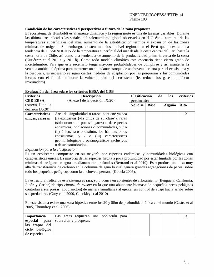
UNEP/CBD/RW/EBSA/ETTP/1/4
Página 183
/…
Condición de las características y perspectivas a futuro de la zona propuesta
El ecosistema de Humboldt es altamente dinámico y la región norte es una de las más variables. Durante
las últimas tres décadas las señales del calentamiento global observadas en el Océano: aumento de las
temperaturas superficiales del mar, aumento de la estratificación térmica y expansión de las zonas
mínimas de oxígeno. Sin embargo, existen modelos a nivel regional en el Perú que muestran una
tendencia de DISMINUCION de la temperatura superficial del mar desde la costa central del Perú hasta la
costa norte de Chile, así como una tendencia de aumento de la productividad primaria cerca de la costa
(Gutiérrez et al 2011a y 2011b). Como todo modelo climático este escenario tiene cierto grado de
incertidumbre. Para que este escenario tenga mayores probabilidades de cumplirse y así mantener la
ventana ambiental óptima para mantener un abundante estoque de anchoveta peruana para el ecosistema y
la pesquería, es necesario se sigan ciertas medidas de adaptación por las pesquerías y las comunidades
locales con el fin de aminorar la vulnerabilidad del ecosistema (ie. reducir los gases de efecto
invernadero).
Evaluación del área sobre los criterios EBSA del CDB
Criterios
CBD EBSA
(Anexo I de la
decisión IX/20)
Descripción
(Anexo I de la decisión IX/20) Clasificación de los criterios
pertinentes
No lo se Bajo Alguno Alto
Características
únicas, rarezas
Área de singularidad o rareza contiene ya sea
(i) exclusivas («la única de su clase"), raras
(sólo ocurre en pocos lugares) o de especies
endémicas, poblaciones o comunidades, y / o
(ii) único, raro o distinto, los hábitats o los
ecosistemas, y / o (iii) características
geomorfológicos u oceanográficos exclusivos
o desacostumbrados.
X
Explicación para la clasificación
Es un ecosistema compuesto en su mayoría por especies endémicas y comunidades biológicas con
características únicas. La mayoría de las especies habita a poca profundidad por estar limitada por las zonas
mínimas de oxígeno en aguas medianamente profundas (Bertrand et al 2010). Esto produce una tasa muy
alta de transferencia de carbono en la columna de agua lo cual genera grandes agregaciones de peces, sobre
todo los pequeños pelágicos como la anchoveta peruana (Kudela 2005).
La estructura trófica de este sistema es rara, solo ocurre en corrientes de afloramiento (Benguela, California,
Japón y Caribe) de tipo cintura de avispa en la que una abundante biomasa de pequeños peces pelágicos
controlan a sus presas (zooplancton) de manera simultánea al ejercer un control de abajo hacía arriba sobre
sus predadores (Cury et al 2000, Checkley et al 2010)
En este sistema existe una zona hipóxica entre los 20 y 50m de profundidad, única en el mundo (Castro et al
2005, Thumdrop et al. 2006).
Importancia
especial para
las etapas del
ciclo biológico
de especies
Las áreas requieren una población para
sobrevivir y prosperar.
X
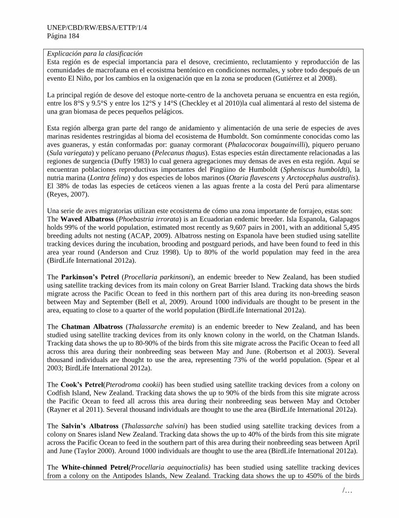
UNEP/CBD/RW/EBSA/ETTP/1/4
Página 184
/…
Explicación para la clasificación
Esta región es de especial importancia para el desove, crecimiento, reclutamiento y reproducción de las
comunidades de macrofauna en el ecosistma bentónico en condiciones normales, y sobre todo después de un
evento El Niño, por los cambios en la oxigenación que en la zona se producen (Gutiérrez et al 2008).
La principal región de desove del estoque norte-centro de la anchoveta peruana se encuentra en esta región,
entre los 8°S y 9.5°S y entre los 12°S y 14°S (Checkley et al 2010)la cual alimentará al resto del sistema de
una gran biomasa de peces pequeños pelágicos.
Esta región alberga gran parte del rango de anidamiento y alimentación de una serie de especies de aves
marinas residentes restringidas al bioma del ecosistema de Humboldt. Son comúnmente conocidas como las
aves guaneras, y están conformadas por: guanay cormorant (Phalacocorax bougainvilli), piquero peruano
(Sula variegata) y pelícano peruano (Pelecanus thagus). Estas especies están directamente relacionadas a las
regiones de surgencia (Duffy 1983) lo cual genera agregaciones muy densas de aves en esta región. Aquí se
encuentran poblaciones reproductivas importantes del Pingüino de Humboldt (Spheniscus humboldti), la
nutria marina (Lontra felina) y dos especies de lobos marinos (Otaria flavescens y Arctocephalus australis).
El 38% de todas las especies de cetáceos vienen a las aguas frente a la costa del Perú para alimentarse
(Reyes, 2007).
Una serie de aves migratorias utilizan este ecosistema de cómo una zona importante de forrajeo, estas son:
The Waved Albatross (Phoebastria irrorata) is an Ecuadorian endemic breeder. Isla Espanola, Galapagos
holds 99% of the world population, estimated most recently as 9,607 pairs in 2001, with an additional 5,495
breeding adults not nesting (ACAP, 2009). Albatross nesting on Espanola have been studied using satellite
tracking devices during the incubation, brooding and postguard periods, and have been found to feed in this
area year round (Anderson and Cruz 1998). Up to 80% of the world population may feed in the area
(BirdLife International 2012a).
The Parkinson’s Petrel (Procellaria parkinsoni), an endemic breeder to New Zealand, has been studied
using satellite tracking devices from its main colony on Great Barrier Island. Tracking data shows the birds
migrate across the Pacific Ocean to feed in this northern part of this area during its non-breeding season
between May and September (Bell et al, 2009). Around 1000 individuals are thought to be present in the
area, equating to close to a quarter of the world population (BirdLife International 2012a).
The Chatman Albatross (Thalassarche eremita) is an endemic breeder to New Zealand, and has been
studied using satellite tracking devices from its only known colony in the world, on the Chatman Islands.
Tracking data shows the up to 80-90% of the birds from this site migrate across the Pacific Ocean to feed all
across this area during their nonbreeding seas between May and June. (Robertson et al 2003). Several
thousand individuals are thought to use the area, representing 73% of the world population. (Spear et al
2003; BirdLife International 2012a).
The Cook’s Petrel(Pterodroma cookii) has been studied using satellite tracking devices from a colony on
Codfish Island, New Zealand. Tracking data shows the up to 90% of the birds from this site migrate across
the Pacific Ocean to feed all across this area during their nonbreeding seas between May and October
(Rayner et al 2011). Several thousand individuals are thought to use the area (BirdLife International 2012a).
The Salvin’s Albatross (Thalassarche salvini) has been studied using satellite tracking devices from a
colony on Snares island New Zealand. Tracking data shows the up to 40% of the birds from this site migrate
across the Pacific Ocean to feed in the southern part of this area during their nonbreeding seas between April
and June (Taylor 2000). Around 1000 individuals are thought to use the area (BirdLife International 2012a).
The White-chinned Petrel(Procellaria aequinoctialis) has been studied using satellite tracking devices
from a colony on the Antipodes Islands, New Zealand. Tracking data shows the up to 450% of the birds
UNEP/CBD/RW/EBSA/ETTP/1/4
Página 185
/…
from this site migrate across the Pacific Ocean to feed in the southern part of this area during their
nonbreeding seas in July and August.( (BirdLife International 2012a).. Up to 70,000 individuals are thought
to use the area (BirdLife International 2012a).
Importancia de
especies
amenazadas, en
peligro o en
declive y/o
hábitats
Áreas que contienen hábitat para la
supervivencia y recuperación de especies en
peligro, amenazadas, especies en declive o
área con agrupamientos significativos de tales
especies.
X
Explicación para la clasificación
En esta región se reproducen especies de predadores tope amenazadas como el Pingüino de Humboldt
(Spheniscus humboldti), la Nutria marina (Lontra felina) y el Potoyunco (Pelecanoides garnotii), estando
este último como críticamente amenazado (García-Godos & Goya 2006; Valqui 2012). Diversas especies de
cetáceos amenazados (ballena jorobada, cachalote, ballena azul, etc.) llegan a esta región cada año para
alimentarse en época no reproductiva (Reyes, 2007).
Waved Albatross (CR), Parkinson’s Petrel (VU),Chatham Albatross (VU), Cook’s Petrel (VU), Salvin’s
Albatross (VU), White-chinned Petrel (VU)
Vulnerabilidad,
fragilidad,
sensibilidad, o
Áreas de lenta
recuperación
Áreas que contengan una proporción
relativamente elevada de hábitats sensibles,
biotopos o especies que son funcionalmente
frágiles (altamente susceptibles a la
degradación o agotamiento por actividades
humanas o por acontecimientos naturales) o
con una lenta recuperación.
X
Explicación para la clasificación
Esta región ha mostrado una capacidad de recuperación muy rápida a pesar de haber sido impactado de
manera muy fuerte tanto por fenómenos naturales (ie. El Niño) como antropogénicos (ie. Pesquería de la
anchoveta) (Chávez & Messié, 2009; Bakun et al. 2010).
Productividad
biológica
Área que contiene especies, poblaciones o
comunidades con relativamente mayor
productividad biológica natural.
X
Explicación para la clasificación
Esta región del ecosistema de Humboldt se considera como la más productiva entre todos los ecosistemas de
afloramiento del mundo (Kudela et al. 2005, Bakun & Broad 2003; Bakun et al. 2008).
Frente a Perú, la producción primaria alcanza valores entre 3 y 4 g C m-2 d-1 en la franja costera de 100 km
(Calienes et al., 1985; Chavez et al., 1989). La alta productividad resulta de la gran disponibilidad de
nutrientes y de factores forzantes favorables que se mantienen durante todo el año (Pocklington, 1981).
Igualmente ciertas áreas altamente productivas coinciden con la presencia de una extensa plataforma,
particularmente entre los 7-10° S (Zuta & Guillén, 1970).
Diversidad
Biológica
Área que contiene una diversidad
relativamente superior de ecosistemas,
hábitats, comunidades, o especies, o tiene una
mayor diversidad genética.
X
Explicación para la clasificación
En esta región se encuentran una diversidad de especies con una genética única, bacterias únicas en el

UNEP/CBD/RW/EBSA/ETTP/1/4
Página 186
/…
mundo y muchos nichos ecológicos verticales (Graco et al 2007). A demás, en ella ocurren el 38% de las
especies de cetáceos del mundo (Reyes 2007).
Naturalidad Área con un grado relativamente mayor de
naturalidad como resultado de la falta o bajo
nivel de perturbación de origen humano o
degradación.
X
Explicación para la clasificación
Dada la alta productividad biológica y su localización costera, existe una alta intervención humana en esta
región por la pesquería industrial y artesanal, actividad petrolera y un alto desarrollo de centros poblados
cerca de la costa (REF).
Referencias
ACAP. 2009. ACAP Species Assessment: Waved Albatross Phoebastria irrorata. Available at:
www.acap.aq/acap-species/download-document/1179-waved-albatross.
Anderson, D. J.; Cruz, F. 1998. Biology and management of the Waved Albatross at the
Galápagos Islands. In: Robertson, G.; Gales, R. (ed.), Albatross biology and conservation, pp.
105-109. Surrey Beatty & Sons Pty Ltd, Chipping Norton, Australia.
Bakun, A. and K. Broad. 2003. Environmental ‘loopholes’ and fish population dynamics:
comparative pattern recognition with focus on El Niño effects in the Pacific. Fisheries
Oceanography 12: 458-473.
Bakun, A. and S. J. Weeks. 2008. The marine ecosystem off Peru: What are the secrets of its
fishery productivity and what might its future hold? Progress in Oceanography 79: 290-299.
Bell, E. A.; Sim, J. L.; Scofield, P. 2009. Population parameters and distribution of the Black
Petrel (Procellaria parkinsoni), 2005/06. Department of Conservation, Wellington, N.Z.
Bertrand, A., M. Ballón and A. Chaigneau. 2010. Acoustic observation of living organisms
reveals the upper limit of the oxygen minimum zone. PLoS ONE 5.
BirdLife International. 2012a. Tracking ocean wanderers: the global distribution of albatrosses
and petrels. BirdLife International, Cambridge, U.K. www.seabirdtracking.org
BirdLife International (2012b) Important Bird Areas factsheet. Downloaded from
www.birdlife.org/datazone/site/search on 29/08/2012
BirdLife International (2012c) IUCN Red List for birds. Downloaded from
www.birdlife.org/datazone/species/search
BirdLife International (2012d). the BirdLife seabird foraging range database: Seabird foraging
range and behaviour factsheets. http://seabird.wikispaces.com
Calienes, R., O. Guillen y N. Lostanau. 1985. Variabilidad espacio-temporal de clorofila,
producción primaria y nutrients frente a la costa Peruana Bol. Inst. Mar.Perú-Callao 10 (1). 44P.
Large, W. G., and S. Pond, 1981: Open ocean momentum flux measurements in mode rate to
strong winds. J. Phys. Oceanogr., 11,pp 324-336
Castro-Gonzalez, M., G. Braker, L.Farias, and O. Ulloa. 2005. Communities of nirs-type
denitrifiers inthe water column of the oxygen minimum zone in the eastern South Pacific.
Environ. Microbiol. 7: 1298–1306.
Chavez, F.P.; R.T. Barber & M.P. Sanderson. 1989. The potential Primary Production of the
Peruvian Upwelling System. Instituto del Mar del Peru (IMARPE), Deutshe Gesellschafr fur
Technische Zusammenarbeit (GTZ) and International Center for Living Aquatic Resources
Mangement (ICLARM).

UNEP/CBD/RW/EBSA/ETTP/1/4
Página 187
/…
Chávez, F., Ryan, J, Lluch-Cota, SE and Ñiquen, MC. 2003. From Anchovies to Sardines and
Back: Multidecadal change in the Pacific Ocean. Science 299: 217-221
Chávez, F. and Messié, M. 2009. A comparison of Eastern Boundary Upwelling Ecosystems.
Progress in Oceanography 83: 80–96
Checkley, D., J. Alheit, Y. Oozeki and C. Roy. 2009. Climate Change and Small Pelagic Fish.
Cambridge University Press.
Cury, P., and Roy, C., 1989. Optimal environmental window and pelagic fish recruitment success
in upwelling areas. Canadian Journal of Fisheries and Aquatic Sciences 46, 670-680
Cury, P., Bakun, A., Crawford, R. J. M. et al. 2000. Small pelagics in upwelling systems: patterns
of interaction and structural changes in “wasp-waist” ecosystems. ICES J. Mar. Sci. 57: 603–618.
Duffy, D. 1983. The foraging ecology of Peruvian seabirds. The Auk. 100 (4): 800-810
García-Godos, I. & Goya, E. 2006. Diet of the Peruvian Diving Petrel Pelecanoides garnotii at La
Vieja Island, Peru, 1997–2000: Potential fishery interactions and conservation implications.
Marine Ornithology 34: 33-41
Graco, M., Ledesma, J., Flores, G., Girán, M. 2007 Nutrientes, oxígeno y procesos
biogeoquímicos en el sistema de surgencias de la corriente de Humboldt frente a Perú. Rev. Per.
Biol. 14(1)
Gutiérrez, D., E. Enríquez, S. Purca, L. Quipúzcoa, R. Marquina, G. Flores and M. Graco. 2008.
Oxygenation episodes on the continental shelf of central Peru: Remote forcing and benthic
ecosystem response. Progress in Oceanography.
Gutiérrez, D., A. Bertrand, C. Wosnitza-Mendo, B. Dewitte, S. Purca, C. Peña, A. Chaigneau, J.
Tam, M. Graco, V. Echevin, C. Grados, P. Freón and R. Guevara-Carrasco. 2011a. Sensibilidad
del sistema de afloramiento costero del Perú al cambio climático e implicancias ecológicas.
Revista Peruana Geo-Atmosférica 3: 1-24.
Gutiérrez, D., I. Bouloubassi, A. Sifeddine, S. Purca, K. Goubanova, M. Graco, D. Field, L.
Méjanelle, F. Velazco, A. Lorre, R. Salvatecci, D. Quispe, G. Vargas, B. Dewitte and L. Ortlieb.
2011b. Coastal cooling and increased productivity in the main upwelling zone off Peru since the
mid-twentieth century. Geophysical Research Letters 38: 1-6.
Hidalgo, P., Escribano, R. And C.E. Morales (2005). Ontogenetic vertical distribution and diel
migration of the copepod Eucalanus inermis in the oxygen minimum zone off northern Chile.
Journal of
Plankton Research 27: 519-529
Kudela, R., Pitcher, G., Probyn, T. etal 2005. Algal Blooms in Coastal Upwelling Systems.
Oceanography. 18(2):184-197
Mann, K.H. and J.R.N. Lazier. 1991. Dynamics of marine ecosystems: 563.Oxford, Blackwell
Scientific Publications.
Pocklington, R. 1981. Organic matter in upwelling off Northern Perú, November 1977. Bol. Inst.
Mar Perú. (Vol. extraordinario ICANE): 7-14.
Rayner M. J.; Hauber M. E.; Steeves, T. E.; Lawrence, H. A.; Thompson, D. R.; Sagar, P. M.;
Bury, S. J.; Landers, T. J.; Phillips, R. A.; Ranjard, L.; Shaffer, S. A. 2011. Contemporary and
historic separation of transhemispheric migration between two genetically distinct seabird
populations. Nature Communications 2.
Reyes Robles, JC. 2009. Ballenas, delfines y otros cetáceos del Perú- Una fuente de información.
Squema-Ediciones. Lima, Perú. 159pp.
Robertson, C. J. R.; Bell, D.; Sinclair, N.; Bell, B. D. 2003. Distribution of seabirds from New
Zealand that overlap with fisheries worldwide.

UNEP/CBD/RW/EBSA/ETTP/1/4
Página 188
/…
Sherman, K., Lewis A, M. and Gold, D. (eds).1993. Large Marine Ecosystems: Stress, mitigation
and sustainability. AAAS Publication, Wasington DC, USA.
Spear, L. B.; Ainley, D. G.; Webb, S. W. 2003. Distribution, abundance and behaviour of
Buller's, Chatham Island and Salvin's Albatrosses off Chile and Peru. Ibis 145: 253-269.
Taylor, G. A. 2000. Action plan for seabird conservation in New Zealand. Department of
Conservation, Wellington.
Thamdrup, B., Dalsgaard, T., Jensen, M. M., Ulloa, O., Farías, L. and R. Escribano. 2006.
Anaerobic ammonium oxidation in the oxygen-deficient waters off northern Chile. Limnology
and Oceanography 51, 2145-2156.
Valqui, J. 2012. The marineotter Lontra felina (Molina, 1782): A review of its present status and
implications for future conservation. Mammalian Biology 77: 75–83
Wooster, W.S. & M. Gilmartin. 1961. The Peru-Chile Undercurrent. Journal of Marine Research
(19): 97-122.
Zuta, S. & O.G. Guillén. 1970. Oceanografía de las aguas costeras del Perú. Bol. Inst. Mar Perú
(2): 157-324.

UNEP/CBD/RW/EBSA/ETTP/1/4
Página 189
/…
Mapas y cifras
Derechos y permisos
Seabird tracking data used in this analysis is property of the data owners, images provided here can be
used with appropriate credits. Any request to publish these images elsewhere or to use the original
tracking data will require permission; requests should be made to BirdLife International
UNEP/CBD/RW/EBSA/ETTP/1/4
Página 190
/…
ÁREA NO. 14: CENTROS DE SURGENCIA PERMANENTES Y AVES MARINAS ASOCIADAS
A LA CORRIENTE DE HUMBOLDT EN PERÚ
(PERMANENT UPWELLING CORES AND IMPORTANT SEABIRD AREAS OF THE
HUMBOLDT CURRENT IN PERU)
Resumen
La surgencia en el ecosistema del Perú es inducida principalmente porel viento paralelo a la costa, y es
altamente modificado por otros factores, como la profundidad de la termoclina, el efecto de lamorfología
de la costa y topografía del fondo marino. En la costa de Perú esto ha generado una serie de centros de
surgencia que son de alta importancia para la agregación de predadores marinos, como es el caso de las
agregaciones más densas de aves marinas del mundo: las aves guaneras. Estos centros de surgencia son
cruciales para que el sistema de Humboldt se reestablezca después de cualquier evento de calentamiento y
durante aquellos eventos sirve a manera de refugio, dado la persistencia de la surgencia en ellas
Introducción La surgencia en el ecosistema del Perú es inducida principalmente porel viento paralelo a la costa, el cual
entrega energía a la capa deagua superficial provocando un transporte neto de agua hacia el oesteproducto
del efecto Coriolis (Smith et al., 1995). Sin embargo esteproceso físico es altamente modificado por otros
factores, tales comola profundidad de la termoclina sujeta a efectos remotos desde la zonaecuatorial
(Chavez et al., 1999), y también por el efecto de lamorfología de la costa y la topografía del fondo marino
(Takesue andvan Geen, 2002). La combinación de estos factores da lugar a una altaheterogeneidad
espacial de la surgencia, tal que los centros desurgencia tienden a asociarse a sectores de salientes del
continente,como puntas o penínsulas de variados tamaños. Estas salientes delcontinente también se
asocian a bahía semi-protegidas donde seconcentran nutrientes y agua cálidas dando lugar a las “sombras
de surgencia” (Graham et al., 1992). La combinación de estos focos de surgencia activa con puntas
costeras y sus sombras de surgencia generan áreas relativamente pequeñas (<100 km) que concentran
elefecto fertilizador de la surgencia y se transforman en sitios deagregaciones de plancton, peces y que
atraen comunidades de avesmarinas, mamíferos, invertebrados y peces para alimentación y reproducción.
Estoscentros de surgencia activa son claramente distinguibles a lo largo dela costa del Perú y constituyen
áreas que concentran las comunidadesbiológicas en torno a un centro muy productivo.Estos centros de
surgencia son cruciales para que el sistema de Humboldt se reestablezca después de cualquier evento de
calentamiento. Cerca de estas zonas siempre existe una mayor concentración de fitoplancton por el
afloramiento intenso de nutrientes hacía la superficie generando áreas óptimas de forrajeo para predadores
superiores como aves marinas.
Ubicación Se han identificado seis focos localizados en centros de acción biológica dónde la fricción de vientos
intensos sobre la morfología de las salientes de la costa generan los centros de surgencia más importantes
de la Corriente de Humboldt. Estos son: 1.- Punta Aguja (5°47´S), 2.- Chimbote (9°5S), 3.- Callao
(12°59´S), 4.-Paracas (13°45´S), 5.-Punta San Juan (15°22´S), 6.- Punta Atico (16°14S)
Estos puntos focales se han delimitado con un área buffer circular con un radio de 75 km desde el punto
de localización del foco de surgencia bajo el criterio de la máxima distancia de forrajeo de aves marinas
que se reproducen en este sistema (BirdLife 2012, Chiu et al. 2011).
The guano birds are the guanay cormorant (Phalacocorax bougainvilli), the Peruvian booby (Sula
variegata) and the Peruvian pelican (Pelecanus thagus). These are the key species captured within the
boundaries defined here, and provide justification for setting these limits. The species that have been
tracked, and used to define these boundaries, include Guanay Cormorant and Peruvian Booby
(Weimerskirch et al 2012), Humboldt Penguin (Culik and G. Luna-Jorquera 1997; Luna-Jorquera and
Culik 1999), Brown Pelican (Croll et al 1986)

UNEP/CBD/RW/EBSA/ETTP/1/4
Página 191
/…
Descripción de las características del área propuesta
Estos centros de surgencia constituyen áreas que concentran las comunidadesbiológicas siendo cruciales
para que el sistema de Humboldt se re-establezca después de cualquier evento de calentamiento. Cerca de
estas zonas siempre existe una mayor concentración de fitoplancton por el afloramiento intenso de
nutrientes hacía la superficie generando áreas óptimas de forrajeo para predadores superiores como aves
marinas.
Condición de las características y perspectivas a futuro de la zona propuesta
Estos centros muestran los patrones típicos del ecosistema de afloramiento de la corriente de Humboldt y
a su vez características únicas de los centros más estables de afloramiento. El sistema de seis centros
pequeños en red permitirá hacer un monitoreo de los patrones y a su vez de la variabilidad que existe en el
ecosistema y de los predadores que utilizan estos lugares como centros de alimentación y reproducción.
Evaluación del área sobre los criterios EBSA del CDB
Criterios
CBD EBSA
(Anexo I de la
decisión IX/20)
Descripción
(Anexo I de la decisión IX/20) Clasificación de los criterios
pertinentes
No lo se Bajo Alguno Alto
Características
únicas, rarezas
Área de singularidad o rareza contiene ya sea
(i) exclusivas («la única de su clase"), raras
(sólo ocurre en pocos lugares) o de especies
endémicas, poblaciones o comunidades, y / o
(ii) único, raro o distinto, los hábitats o los
ecosistemas, y / o (iii) características
geomorfológicos u oceanográficos exclusivos
o desacostumbrados.
X
Explicación para la clasificación
Estos centros únicos en el mundo. Son cruciales para la resilencia del ecosistema de Humboldt. El
ecosistema de Humboldt se ha podido reestablecer después de fuertes presiones naturales (ie. Eventos El
Niño), antropogénicas (ie. Pesquería industrial de la anchoveta) y efectos de su sinergia (Bakun & Weeks
2008). No existe ecosistema en el mundo que sometido a una presión tan fuerte sea tan resilente (Bakun &
Broad 2003; Bakun & Weeks 2008). Esta resilencia se logra mantener por la intenso afloramiento producido
en los focos de surgencia (Punta Aguja, Chimbote, Callao, Paracas, Punta San Juan y Punta Atico) por el
mantenimiento de los procesos de oxigencación. A demás, a este sistema están asociadas las agregaciones
más densas de aves marinas (aves guaneras) del mundo (Duffy 1983). las colonias más densas del lobos
marino de un pelo (Otaria flavescens) y en los centrosdel lobo marinos fino (Arctocephalus australis)
Importancia
especial para
las etapas del
ciclo biológico
de especies
Las áreas requieren una población para
sobrevivir y prosperar.
X
Explicación para la clasificación
Esta región al englobar la mayoría de los centros de surgencia, concentra las zonas óptimas de reclutamiento
de peces pequeños pelágicos, como es el caso de la anchoveta peruana (Engraulis ringens) (Cury et al
1989).
La anchoveta peruana es la presa principal de las aves marinas asociadas a los centros de surgencias. Estas
son comúnmente conocidas como las aves guaneras, y están conformadas por: guanay cormorant
(Phalacocorax bougainvilli), piquero peruano (Sula variegata) y pelícano peruano (Pelecanus thagus).

UNEP/CBD/RW/EBSA/ETTP/1/4
Página 192
/…
Estas especies están directamente relacionadas a las regiones de surgencia (Duffy 1983) lo cual genera
agregaciones muy densas de aves en esta región. Aquí se encuentran poblaciones reproductivas importantes
del Pingüino de Humboldt (Spheniscus humboldti), la nutria marina (Lontra felina) y dos especies de lobos
marinos (Otaria flavescens y Arctocephalus australis). El 38% de todas las especies de cetáceos vienen a las
aguas frente a la costa del Perú para alimentarse (Reyes, 2007).
Estos centros albergan gran parte del rango de anidamiento y alimentación de una serie de especies de aves
marinas residentes restringidas al bioma del ecosistema de Humboldt. A continuación se describen las
colonias de aves marinas más importantes que se asocian con cada uno de los centros de surgencias:
Punta Aguja
Isla Lobos de Afuera holds a breeding colony of guano species, which occur here in globally significant
numbers, with the site qualifying as an Important Bird Area (IBA) under BirdLife International criteria
(BirdLife International 2012). The area includes the foraging areas for these species around the island. The
species of international significance are the Humboldt Penguin (Spheniscus humboldti), Red-legged
Cormorant (Phalacrocorax gaimardi), Peruvian Booby (Sula variegate), Inca Tern (Larosterna inca) and
Peruvian Pelican (Pelecanus thagus). Around 250,000 pairs of the latter species breed.
Isla Lobos de Tierra holds a breeding colony of guano species, which occur here in globally significant
numbers, with the site qualifying as an Important Bird Area (IBA) under BirdLife International criteria
BirdLife International 2012). The area includes the foraging areas for these species around the island. The
species of international significance are 1000 pairs of Humboldt Penguin (Spheniscus humboldti), Red-
legged Cormorant (Phalacrocorax gaimardi), Guanay Cormorant (phlacrocorax bougainvillii), Peruvian
Booby (Sula variegate), 15,000 pairs of Blue-footed Booby (Sula nebouxii), Peruvian Pelican (Pelecanus
thagus) and 13,000 individuals of Peruvian Diving-petrel (Pelecanoides garnotii). The latter species occur
here at its northern most breeding colony.
Chimbote
Macabí and Guañape Norte hold breeding colonies of guano species, which occur here in globally
significant numbers, with the site qualifying as an Important Bird Area (IBA) under BirdLife International
criteria (BirdLife International 2012). The area includes the foraging areas for these species around the
island. The species of international significance are: Red-legged Cormorant (Phalacrocorax gaimardi),
Guanay Cormorant (phlacrocorax bougainvillii), Peruvian Booby (Sula variegate), and Peruvian Pelican
(Pelecanus thagus)
Isla Pachacamac holds a breeding colony of guano species, which occur here in globally significant
numbers, with the site qualifying as an Important Bird Area (IBA) under BirdLife International criteria
(BirdLife International 2012). The area includes the foraging areas for these species around the island. The
species of international significance are Grey gull (Larus modestus), Humboldt Penguin (Spheniscus
humboldti), Red-legged Cormorant (Phalacrocorax gaimardi), Peruvian Booby (Sula variegate), Peruvian
Pelican (Pelecanus thagus) and Markham’s Storm-petrel (Oceanodroma markhami),
Callao
Pantanos de Villa holds a breeding colony of Band-tailed Gull (larus belcheri), which occur here in globally
significant numbers, with the site qualifying as an Important Bird Area (IBA) under BirdLife International
criteria (BirdLife International 2012). The area includes the foraging areas for these species around the
island
Punta Pampa Redonda holds a breeding colony of Humboldt Penguin (Spheniscus humboldti) including
1800 individuals occurring here in globally significant numbers, with the site qualifying as an Important
Bird Area (IBA) under BirdLife International criteria (BirdLife International 2012). The area includes the
foraging areas for these species around the island.
UNEP/CBD/RW/EBSA/ETTP/1/4
Página 193
/…
Paracas
Reserva Nacional de Paracas holds a breeding colony of guano species, which occur here in globally
significant numbers, with the site qualifying as an Important Bird Area (IBA) under BirdLife International
criteria (BirdLife International 2012). The area includes the foraging areas for these species around the
island. The species of international significance are Grey Gull (Larus modestus), Humboldt Penguin
(Spheniscus humboldti), Inca Tern (Larosterna inca), Peruvian Booby (Sula variegate), Peruvian Pelican
(Pelecanus thagus), Peruvian Diving-petrel (Pelecanoides garnotii), Peruvian Tern (Sterna lorata), and Red-
legged Cormorant (Phalacrocorax gaimardi). The Markham’s Storm-petrel (Oceanodroma markhami) also
breeds here, the only known colony in the world of this species.
Chinchas holds a breeding colony of guano species, which occur here in globally significant numbers, with
the site qualifying as an Important Bird Area (IBA) under BirdLife International criteria (BirdLife
International 2012). The area includes the foraging areas for these species around the island. The species of
international significance are Humboldt Penguin (Spheniscus humboldti), Guanay Cormorant (phlacrocorax
bougainvillii), and Peruvian Diving-petrel (Pelecanoides garnotii). In early 20th century the site held over
five and a half million pairs of cormorants, though has declined significantly since that time.
Punta San Juan
Punta San Juan holds a breeding colony of Humboldt Penguin (Spheniscus humboldti) including 3600
individuals occurring here in globally significant numbers, with the site qualifying as an Important Bird
Area (IBA) under BirdLife International criteria (BirdLife International 2012). The area includes the
foraging areas for these species around the island.
Punta Atico
Smaller sites with significant numbers of Humboldt penguins, Peruvian pelicans, Peruvian Boobies and
Guanay cormorants are supported by the upwelling of Punta Atico (BirdLife International 2012).
Las especies migratorias que se han registrado asociados a estos centros de surgencia son:
Ringed Storm-petrel (Oceanodroma hornbyi), a species whose breeding grounds have never been found.
The area is also known to be an important feeding area for a range of migratory seabird species including
Buller’s Shearwater (Puffinus bulleri), Cook’s Petrel (Pterodroma cookie), Elegant Tern (Sterna elegans),
Galapagos Petrel (Pterodroma phaeopygia), Pink-footed Shearwater (Puffinus creatopus), and Waved
Albatross (Phoebastria irrorata)
Importancia de
especies
amenazadas, en
peligro o en
declive y/o
hábitats
Áreas que contienen hábitat para la
supervivencia y recuperación de especies en
peligro, amenazadas, especies en declive o
área con agrupamientos significativos de tales
especies.
X
Explicación para la clasificación
En Punta San Juan, uno de los focos de surgencia se encuentra la colonia más grande del Pingüino de
Humboldt (Spheniscus humboldti), el cual se encuentra amenazado según IUCN. En los focos de surgencia-
Paracas, Punta San Juan, Punta Atico y Punta Coles- se encuentra prácticamente toda la población del lobo
marino fino (Arctocephalus australis), especie protegida dentro del Perú y enlistada en CITES II.
Resident populations
Threatened seabird species known to forage in these areas when breeding include Humboldt Penguin (VU),
Peruvian Diving-petrel (EN), Markham’s Storm-petrel (DD), Red-legged Cormorant (NT), Peruvian pelican
(NT), and Peruvian Tern (EN).

UNEP/CBD/RW/EBSA/ETTP/1/4
Página 194
/…
Migratory species
Other threatened seabird species known to occur here include Ringed Storm-petrel (DD), whose breeding
sites have never been found, and migratory seabird species including Buller’s shearwater (VU), Cook’s
Petrel (VU), Elegant Tern (NT), Galapagos Petrel (CR), Pink-footed Shearwater (VU), and Waved
Albatross (CR)
Vulnerabilidad,
fragilidad,
sensibilidad, o
Áreas de lenta
recuperación
Áreas que contengan una proporción
relativamente elevada de hábitats sensibles,
biotopos o especies que son funcionalmente
frágiles (altamente susceptibles a la
degradación o agotamiento por actividades
humanas o por acontecimientos naturales) o
con una lenta recuperación.
X
Explicación para la clasificación
Because upwelling is persistant thru the year, this system will have optimal conditions and high levels of
oxygen and nutrient throughout the year. This is particularly important to influx the system with nutrients
after a warming event (ie. El Niño) allowing this system to recover relatively fast. This will in turn allow the
populations of top predators to recover rapidly after catastrophic declines (ie. Arctocephalus australis,
Cárdenas-Alayza, 2012).
All seabirds are long lived (several decades) and slow at reproducing (normally 1 chick a year, and often
taking several years to reach maturity) making them vulnerable and slow to recover following declines.
All of the seabird species here rely almost exclusively on the anchoveta as a prey item. Changes in the
abundance and distribution of this fish, for example in El Niño years, have been shown to alter the species
foraging ecology, negatively affect productivity, and cause adult starvation leading to population crashes
(Bertrand et al 2012).
Productividad
biológica
Área que contiene especies, poblaciones o
comunidades con relativamente mayor
productividad biológica natural.
X
Explicación para la clasificación
La surgencia en estos centros de surgencia es producida porel viento paralelo a la costa, el cual entrega
energía a la capa deagua superficial provocando un transporte neto de agua hacia el oesteproducto del efecto
Coriolis (Smith et al., 1995). Sin embargo esteproceso físico es altamente modificado por otros factores,
tales comola profundidad de la termoclina sujeta a efectos remotos desde la zonaecuatorial (Chavez et al.,
1999), y también por el efecto de lamorfología de la costa y la topografía del fondo marino (Takesue andvan
Geen, 2002). La combinación de estos factores da lugar a una altaheterogeneidad espacial de la surgencia,
tal que los centros de surgencia tienden a asociarse a sectores de salientes del continente,como puntas o
penínsulas de variados tamaños.
Estas salientes delcontinente también se asocian a bahía semi-protegidas donde seconcentran nutrientes y
agua cálidas dando lugar a las “sombras de surgencia” (Graham et al., 1992). La combinación de estos focos
de surgencia activa con puntas costeras y sus sombras de surgencia generan áreas relativamente pequeñas
(<100 km) que concentran elefecto fertilizador de la surgencia y se transforman en sitios deagregaciones de
plancton, peces y que atraen comunidades de avesmarinas, mamíferos, invertebrados y peces para
alimentación y reproducción. Estoscentros de surgencia activa son claramente distinguibles a lo largo dela
costa del Perú y constituyen áreas que concentran las comunidadesbiológicas en torno a un centro muy
productivo.
Como un foco de surgencia especial, se ha reconocido que Punta San Juan es considerado como el centro de
surgencia más productivo del mundo (Bakun & Weeks 2008).
UNEP/CBD/RW/EBSA/ETTP/1/4
Página 195
/…
Diversidad
Biológica
Área que contiene una diversidad
relativamente superior de ecosistemas,
hábitats, comunidades, o especies, o tiene una
mayor diversidad genética.
X
Explicación para la clasificación
Los centros de surgencia son una fuente de biodiversidad propia del HCS, pero más bien se caracterizan por
la abundancia de las especies presentes en ellas.
Naturalidad Área con un grado relativamente mayor de
naturalidad como resultado de la falta o bajo
nivel de perturbación de origen humano o
degradación.
X
Referencias
Alheit, J. and P. Bernal. 1993. Effects of physical and biological changes on the biomass yield of
the Humboldt Current Ecosystem. Pages 53-68 in K. SHERMAN, A. LEWIS M and B. D. GOLD
eds. Large Marine Ecosystems: Stress, mitigation and sustainability. AAAS Publication,
Wasington DC, USA.
Bakun, A. 1975. Daily and weekly upwelling indices, west coast of North América, 1967-73.
U.S. Commer. NOAA Tech. Rep. NMFS-SSRS-693, pp 113.
Bakun A., 1990. Global Climate Change and Intensification of Coastal Ocean Upwelling.
Science, (247), 4939, pp. 198-201.
Bakun, A. and Parrish. 1982. Turbulence, Transport, and pelagic fish in the California and Peru
Current Systems. CalCOFI. Rep., XXIII. 99-112
Bakun, A. and S. J. Weeks. 2008. The marine ecosystem off Peru: What are the secrets of its
fishery productivity and what might its future hold? Progress in Oceanography79: 290-299.
Bertrand S., Rocio J., Smet C.A., Tremblay Y., Christophe Barbraud C. and Weimerskirch H.
(2012). Local depletion by a fishery can affect seabird foraging. Journal of Applied Ecology. Doi:
10.1111/j.1365-2664.2012.02190.
BirdLife International (2012b) Important Bird Areas factsheet. Downloaded from
www.birdlife.org/datazone/site/search on 29/08/2012
Capet X. J., P Machesiello, and J.C. McWillians. 2004. Upwelling response to coastal wind
profiles. Geophysical Research Letters, 31, L13311, doi: 10.1029/2004/GL020123
Chavez, F. P., P. G. Strutton, C. E. Friederich, R. A. Feely, G. C., Feldman, D. C. Foley, and M.
J. McPhaden (1999), Biological and chemical response of the equatorial Pacific Ocean to the
1997 – 98 El Niño, Science, 286, 2126–2131.
Chiu Werner, A., Cárdenas Alayza, S., Cardeña Mormontoy, M., Bussalleu Cavero, A., Guerrero
Bustamante, P., Sandoval García, F. & Y. Tremblay. 2011. La ruta del ping ino: Uso de hábitat
marino y patrón de atención al nido por el Ping ino de Humboldt (Spheniscus humboldti) en
Punta San Juan, Perú. Boletín Informativo de la Unión de Ornitólogos del Perú (UNOP), 6 (2):
21-27
Croll D., Balance L.T., Wursig B. and Tyler WM (1986).Movements and daily activity patterns
of a brown Pelican in central California. The Condor 88:258-260
Culik, B. M. and G. Luna-Jorquera (1997). Satellite tracking of Humboldt penguin in northern
chile. Marine Biology Volume 128, Number 4 (1997), 547-556,
UNEP/CBD/RW/EBSA/ETTP/1/4
Página 196
/…
Duffy, D. 1983. The foraging ecology of Peruvian seabirds. The Auk. 100 (4): 800-810
García-Godos, I. & Goya, E. 2006. Diet of the Peruvian Diving Petrel Pelecanoides garnotii at La
Vieja Island, Peru, 1997–2000: Potential fishery interactions and conservation implications.
Marine Ornithology 34: 33-41
Graham W, Field J, Potts D (1992) Persistent ‘upwelling shadows’and their influence on
zooplankton distributions. Mar Biol 114:561–570
Luna-Jorquera, G. & Culik, B.M. 1999. Diving behaviour of Humboldt Penguins Spheniscus
humboldtiin northern Chile. Marine Ornithology27: 67–76.
Smith RL (1995) The physical processes of coastal ocean upwellingsystems. In: Summerhayes
CP, Emeis KC, Angel MV, Smith RL, Zeitzchel B(eds) Upwelling in the ocean: modern
processes and ancient records.John Wiley & Sons, New York, p 39–64
Takesue, R. K., and A. van Geen (2002), Nearshore circulation duringupwelling inferred from the
distribution of dissolved cadmium off theOregon coast., Limnol. Oceanogr., 47, 176–185.
Weimerskirch H., Bertrand S., Silva J., Bost C, Peraltilla S. (2012). Foraging in Guanay
cormorant and Peruvian booby, the major guano-producing seabirds in the Humboldt Current
System. Marine Ecology Progress Series 458: 231–245, 2012

UNEP/CBD/RW/EBSA/ETTP/1/4
Página 197
/…
Mapas y cifras
Derechos y permisos
Seabird tracking data used in this analysis is property of the data owners, images provided here can be
used with appropriate credits. Any request to publish these images elsewhere or to use the original
tracking data will require permission; requests should be made to BirdLife International
UNEP/CBD/RW/EBSA/ETTP/1/4
Página 198
/…
ÁREA NO. 15: SISTEMA DE SURGENCIA DE LA CORRIENTE DE HUMBOLDT EN EL
NORTE DE CHILE
(NORTHERN CHILE HUMBOLDT CURRENT UPWELLING SYSTEM)
Abstract
The coastal upwelling region of northern Chile between 21° and 24°S includes the El Loa river area, the
coastal upwelling Center of Mejillones Peninsula and surrounding areas. Both El Loa river zone and
Mejillones Peninsula are well known sites of strong biological activity driven by upwelling and within
which both pelagic and benthic communities become concentrated, giving rise to important spawning and
nursery areas for fishes, crustacean and mollusk species. In the region, diversity becomes increased as the
upwelling process can be intermittently present throughout the year. Continuity of upwelling provides
nutrients and hence the flourishing of the large variety of phytoplankton with extremely short life cycles,
and the consequence of this wide spectrum lower trophic level gives the opportunity to evolution of
higher diversity of subsequent trophic levels.
Introduction
The upwelling region of northern Chile is worldwide recognized as a highly productiveecosystem,
sustaining the large fisheries of anchovy and sardine (Alheit and Bernal, 1993; Walsh, 1991; Mann and
Lazier, 1991). One of the interesting features of this region, as compared to other eastern boundary
currents, is the fact that most of its biological production appears restricted to a very narrow continental
shelf, within which coastal upwelling takes place (Fonseca and Far!ıas, 1987; Mar!ın et al., 2001). One of
the important upwelling centers in north of Chile is located off Antofagasta (23S). This site has received
increasing attention in the last decade, motivated by some studies indicating that upwelling may occur
year round (Escribano, 1998; Fonseca and Far!ıas, 1987), promoting continuous primary production
(Mar!ın et al., 1993) and secondary production of zooplankton throughout the year (Escribano and
McLaren, 1999), even under abnormally warm conditions during El Nin˜o (Ulloa et al., 2001; Gonzalez et
al., 2000). Production and abundance of plankton in the nearshore zone of Antofagasta might also be
enhanced by recent observations suggesting that plankton remains aggregated near the shoreline, because
of diminished offshore advection and the presence of retention areas resulting from circulation during
upwelling (Escribano and Hidalgo, 2000; Mar!ın et al., 2001; Giraldo et al., 2002). However, the precise
knowledge about coastal currents off Antofagasta can only be inferred from large-scale geostrophic
estimations based on occasional hydrographic surveys (Strub et al., 1998), and circulation in the
nearshore area may rather exhibit a complex interaction between major currents and variability of winds
during upwelling (Mar!ın et al., 2001). Such interaction might give rise to a variety of physical structures
near the coast, including the cold-upwelling plumes, highly advective areas and zones of particle retention
(Mar!ın et al., 2001; Giraldo et al., 2002), they altogether may act as an efficient mechanism to maintain
plankton populations within inshore waters (Mar!ın et al., 2001; Escribano et al., 2002; Giraldo et al.,
2002). The physical heterogeneity near the coast may certainly result from thedominant circulation
controlled by both baroclinic and barotropic factors, whose combined effects on circulation have not yet
been examined for this important upwelling center.
Location
The proposed area comprises the region between 21°S and 24°S at the northern upwelling region of Chile
with an offshore extension up to 200 km from the coastline (Fig. 1). The region is located within the
jurisdictional area of Chile and it covers the continental shelf and the shelf break off Antofagasta and
surrounding areas.

UNEP/CBD/RW/EBSA/ETTP/1/4
Página 199
/…
Fig.1 The Coastal Upwelling
System in the Northern region
of Chile.
Feature description of the
proposed area
La zona comprendida entre el Río Loa y la Península de Mejillones (Región de Antofagasta) destaca la
gran extensión en el borde costero de las unidades geomorfológicos: Escarpe en Farellón y Farellón
Costero. Además, de la distribución disyunta que presentan las planicies fluviomarinas, pero que cubren
territorialmente sectores significativos, especialmente en la Península de Mejillones(Murillo et al., 2010).
Figura 2. Mapa temático del tipo de rompiente, rugosidades subsuperficiales y barreras físicas en el área.
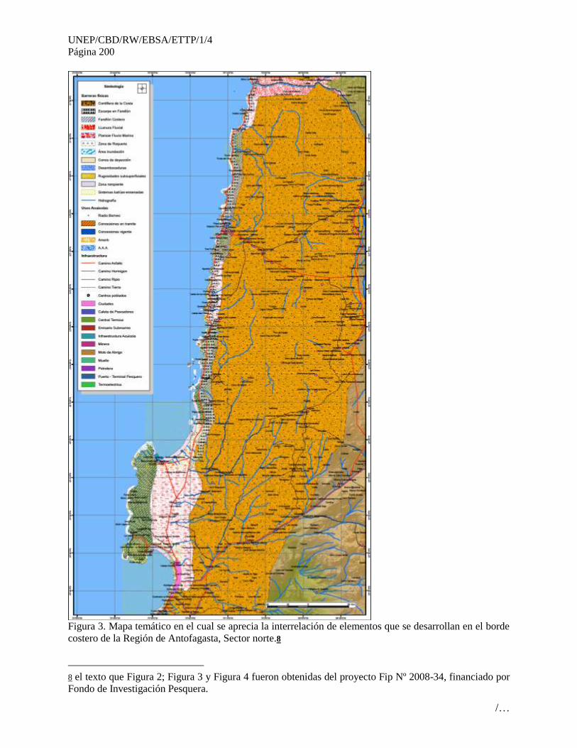
UNEP/CBD/RW/EBSA/ETTP/1/4
Página 200
/…
Figura 3. Mapa temático en el cual se aprecia la interrelación de elementos que se desarrollan en el borde
costero de la Región de Antofagasta, Sector norte.8
8 el texto que Figura 2; Figura 3 y Figura 4 fueron obtenidas del proyecto Fip Nº 2008-34, financiado por
Fondo de Investigación Pesquera.
UNEP/CBD/RW/EBSA/ETTP/1/4
Página 201
/…
Feature condition and future outlook of the proposed area
Estas áreas se caracterizan por una alta diversidad biológica sustentada por los focos de surgencias
cercanos a la costa que se producen por períodos cortos y durante todo el año. Además se destaca la
abundancia de recursos pelágicos de importancia comercial como la anchoveta y la sardina española
(Subpesca, 2006). Cabe señalarse que en este sistema costero chileno los eventos de surgencia se
presentan durante todo el año, alternándose con períodos de relajamiento. La frecuencia de estos eventos
es mayor en verano y la duración de cada uno de ellos es variable y oscila entre 4 y 15 días. Los eventos
de mayor duración se presentan a fines del verano e inicios del otoño, mientras que los de menor duración
ocurren durante los meses de invierno y primavera. Es en este último período donde la extensión de la
surgencia medida desde la costa hacia la zona oceánica alcanza de 20 a 25 millas náuticas (46,3 km),
mientras en verano puede alcanzar las 40 mn (74,08 km), en ambos períodos la “lengua surgente” tiene
dirección W o NW (Barbieri et al., 1995). Es justamente en las primeras 20 mn desde la costa en donde se
concentran las mayores densidades y agregación de recursos pelágicos vinculados a las zonas de borde de
las áreas de surgencia (Pizarro et al., 1994).
Adicionalmente, este sistema costero es afectado por eventos Niño-Niña o de Oscilación del Sur (ENOS),
que se manifiesta por alteraciones de los patrones de distribución de temperatura, salinidad y contenido de
oxígeno disuelto de las masas de agua superficiales. Este cambio en las condiciones ambientales causa
efectos ecológicos, como migraciones batimétricas y geográficas de especies pelágicas, desaparición o
reemplazo temporal de especies, alteración en las comunidades, cambios en la dinámica de poblaciones,
etc. Además, una disminución de los procesos de surgencia (up-welling) e intensas precipitaciones o
sequías en zonas costeras, según sea el caso (e.g., Pizarro et al., 1994)
Assessment of the area against CBD EBSA Criteria
CBD EBSA
Criteria
(Annex I to
decision
IX/20)
Description
(Annex I to decision IX/20) Ranking of criterion relevance
Don’t
Know
Low Some High
Uniqueness or
rarity
Area contains either (i) unique (“the only one of its
kind”), rare (occurs only in few locations) or
endemic species, populations or communities,
and/or (ii) unique, rare or distinct, habitats or
ecosystems; and/or (iii) unique or unusual
geomorphological or oceanographic features.
X
Explanation for ranking
The fertilizing effect of strong seasonal upwelling combined with large inputs of nutrients from winter
runoff (Sobarzo et al., 2007) and rivers generates a unique coastal ecosystem in terms of productivity and
habitat compartments characterized by year-round productivity (Montero et al., 2007). and presence of a
mosaic of estuarine, hypoxic, shallow and deep-sea habitats (Vargas et al., 2007). This mosaic provides
substrate and nourishments for a variety of organisms from microbes to higher vertebrates.
Special
importance
for life-
history stages
of species
Areas that are required for a population to survive
and thrive. X
Explanation for ranking
Many fish populations and invertebrates can complete successfully their life cycles by using the estuarine
habitats for key life stages, such as eggs, larvae and juveniles (Castro et al., 2000, Escribano and Morales
2012).
Importance Area containing habitat for the survival and X
UNEP/CBD/RW/EBSA/ETTP/1/4
Página 202
/…
for
threatened,
endangered
or declining
species
and/or
habitats
recovery of endangered, threatened, declining
species or area with significant assemblages of
such species.
Explanation for ranking
The strong human pressure on this ecosystem from industrial activities, and urban settlements may indicate
the potential for threats for some key species
Vulnerability,
fragility,
sensitivity, or
slow recovery
Areas that contain a relatively high proportion of
sensitive habitats, biotopes or species that are
functionally fragile (highly susceptible to
degradation or depletion by human activity or by
natural events) or with slow recovery.
X
The dependence of river inputs and rainfall for coastal production during the non-upwelling season
(Sobarzo et al., 2007; Vargas et al., 2007) and the increasing human intervention in the coastal zone rise
strong concern of how anthropogenic activities may impact this ecosystem. Also, this ecosystem may be
strongly impacted by natural perturbations, such El Niño and the it seems that recovering from
perturbations at least in the benthic system takes longer than in other upwelling regions (Escribano et al.,
2004).
The impact of ongoing climate change on this ecosystem is also uncertain, but it raises concern upon recent
evidence that upwelling is gradually increasing in this region (Falvey and Garreaud, 2009) rising the mixed
layer with unknown ecological consequences (Bakun et al, 2010).
Biological
productivity
Area containing species, populations or
communities with comparatively higher natural
biological productivity.
X
Explanation for ranking
Some of the highest values of primary production for upwelling systems have been measured over the
continental shelf of this zone, >20 g C/m2 d (Montero et al., 2007)
Biological
diversity
Area contains comparatively higher diversity of
ecosystems, habitats, communities, or species, or
has higher genetic diversity.
X
Explanation for rankingComparatively, this ecosystem exhibit low biodiversity and high dominance of
many components of the benthic and pelagic system (Escribano et al., 2003; Hidalgo et al., 2010, Riquelme-
Bugueño et al., 2012).
Naturalness Area with a comparatively higher degree of
naturalness as a result of the lack of or low level of
human-induced disturbance or degradation.
X
Explanation for rankingAs compared to other systems, this region may not reflect much naturalness,
because of strong influences from human activities in terms of industry, fishery and urban
settlements(Murillo et al., 2010). (Figura 4).
References
Alheit, J., Bernal, P., 1993. Effects of physical and biological changes on the biomass
yield of the Humboldt Current Ecosystem, In: Sherman, K., Alexander, L.M., Gold, B.D.

UNEP/CBD/RW/EBSA/ETTP/1/4
Página 203
/…
(Eds), Large Marine ecosystems. V.: Stress, mitigation and sustainability. AAAS Press,
Washington D.C.
Barbieri, B., M. Bravo, M. Farías, A. González, O. Pizarro & E. Yáñez. 1995.
Fenómenos Asociados a la estructura térmica superficial del mar observados a través de
imágenes satelitales en la zona norte de Chile. Investigaciones Marinas (Chile) 23: 99-
122.
Blanco, J.L., Thomas, A.C., Carr, M.-E., Strub, P.T., 2001. Seasonal climatology of hydrographic
conditions in the upwelling region off northern Chile. Journal of Geophysical Research 106,
11451–11467.
Murillo, V., R. Gonzalez, M.V. Soto, Ch. espinoza & N. Pesse.2010. Diagnóstico y proyección de
las actividades de acuicultura entre arica y taltal. Informe final corregido fip nº 2008-34. 563 pp.
Pizarro, O., S. Hormazábal, A. González & E. Yánez. 1994. Variabilidad del viento, nivel
del mar y temperatura en la costa norte de Chile. Investigaciones Marinas 22:85-101.
Rojas, P., Escribano, R., Mar!ın, V., 2002. The influence of coastal upwelling on fish larvae
distribution off Mejillones Peninsula, northern Chile. Fisheries Oceanography 11, 233–244.
Servicio Nacional de Pesca (Sernapesca). 2006. Anuario Estadístico de Pesca 2005.
Ministro de Economía Fomento y Reconstrucción. Gobierno de Chile. Dirección URL:
http://www.sernapesca.cl/index.php?option=com_remository&Itemid=24
6&func=select&id=2. Visitada en noviembre 2008
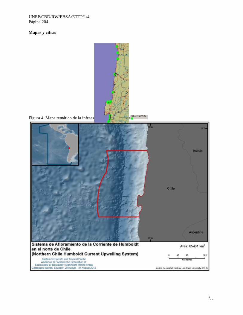
UNEP/CBD/RW/EBSA/ETTP/1/4
Página 204
/…
Mapas y cifras
Figura 4. Mapa temático de la infraestructura en el área de estudio.
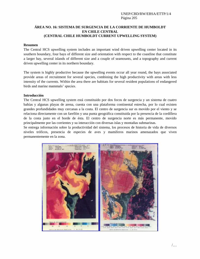
UNEP/CBD/RW/EBSA/ETTP/1/4
Página 205
/…
ÁREA NO. 16: SISTEMA DE SURGENCIA DE LA CORRIENTE DE HUMBOLDT
EN CHILE CENTRAL
(CENTRAL CHILE HUMBOLDT CURRENT UPWELLING SYSTEM)
Resumen
The Central HCS upwelling system includes an important wind driven upwelling center located in its
southern boundary, four bays of different size and orientation with respect to the coastline that constitute
a larger bay, several islands of different size and a couple of seamounts, and a topography and current
driven upwelling center in its northern boundary.
The system is highly productive because the upwelling events occur all year round, the bays associated
provide areas of recruitment for several species, combining the high productivity with areas with less
intensity of the currents. Within the area there are habitats for several resident populations of endangered
birds and marine mammals’ species.
Introducción
The Central HCS upwelling system está constituido por dos focos de surgencia y un sistema de cuatro
bahías y algunas playas de arena, cuenta con una plataforma continental estrecha, por lo cual existen
grandes profundidades muy cercanas a la costa. El centro de surgencia sur es movido por el viento y se
relaciona directamente con un farellón y una punta geográfica constituida por la presencia de la cordillera
de la costa justo en el borde de ésta. El centro de surgencia norte es más permanente, movido
principalmente por las corrientes y su interacción con diversas islas y montañas submarinas.
Se entrega información sobre la productividad del sistema, los procesos de historia de vida de diversos
niveles tróficos, presencia de especies de aves y mamíferos marinos amenazados que viven
permanentemente en la zona.

UNEP/CBD/RW/EBSA/ETTP/1/4
Página 206
/…
Ubicación
The Central HCS upwelling system includes the area between 29 and 31ºS and extends 200 km to the
west.
Evaluación del área sobre los criterios EBSA del CDB
Criterios
CBD EBSA
(Anexo I de la
decisión IX/20)
Descripción
(Anexo I de la decisión IX/20) Clasificación de los criterios
pertinentes
No lo se Bajo Alguno Alto
Características
únicas, rarezas
Área de singularidad o rareza contiene ya sea (i)
exclusivas («la única de su clase"), raras (sólo
ocurre en pocos lugares) o de especies endémicas,
poblaciones o comunidades, y/o (ii) único, raro o
distinto, los hábitats o los ecosistemas, y/o (iii)
características geomorfológicos u oceanográficos
exclusivos o desacostumbrados.
X
Explanation for ranking
The Humboldt Current System (HCS) is one of the most productive marine ecosystems on earth. It extends
along the west coast of South America from southern Chile (~42°S) up to Ecuador and the Galapagos Islands
near the equator Thiel et al. (2007). Along the coast of central Chile, upwelling is localised and its
occurrence is mostly continuous (aseasonal). Upwelling in the coastal zone off northern Chile may exhibit
much spatial variation characterized by discrete upwelling centres, such as the ones observed off Iquique
(20°S), the river Loa (21°S), Mejillones (23°S), Caldera (27ºS) and Coquimbo (30°S) (Fonseca & Farías
1987). Large-scale climatic phenomena (El Niño Southern Oscillation, ENSO) are superimposed onto this
regional pattern, which results in a high spatiotemporal heterogeneity, complicating the prediction of
ecological processes along the Chilean coast. El Niño (EN) events in northern Chile do not appear to cause a
dramatic decline in primary or zooplankton production but rather a shift in species composition, which
affects trophic efficiency of and interactions among higher-level consumers. Another important feature of
this area is the presence of low oxygen concentrations in subsurface waters (oxygen minimum zone, OMZ).
At 30ºS there is a convergence zone where subantarctic waters subduct below warmer waters advected from
the north and also the subtropical atmospheric convergence zone. Furthermore, the coastal range is found
right at the coast and generates a very narrow and almost non existing continental shelf, right at 30ºS.
Finally, in this area several faunal discontinuities have been described for pelagic and even intertidal species.
Importancia
especial para las
etapas del ciclo
biológico de
especies
Las áreas requieren una población para
sobrevivir y prosperar.
X
Explanation for ranking
The Eastern Boundary Current systems, as the HCS, are characterized by being areas where species from all
realms can develop all their life cycle, because they provide food for all trophic levels. Pelagic as well as
demersal and benthic organisms benefit by high productivity in upwelling sites. Zooplankton populations
tend to aggregate in upwelling centres previously listed and hence they are also very patchily distributed
(González & Marín 1998, Escribano & Hidalgo 2000a).Dominant zooplankton species have been suggested
to be strongly associated with upwelling centres (González & Marín 1998, Escribano & Hidalgo 2000b), and
they can thus complete their life cycles within the upwelling zone, growing at temperature-dependent rates
under non-limiting conditions of food (Escribano & McLaren 1999, Giraldo et al. 2002). In the HCS there is
a rich diversity of seabirds, comprising at least 14 breeding species, 9 of which are endemic. According to
available information, along the coast of Chile the most important breeding colonies are found on islands of
UNEP/CBD/RW/EBSA/ETTP/1/4
Página 207
/…
northern-central Chile, near upwelling areas. The HCS is visited regularly by a number of migrant species.
Among the Procelariiformes, whitechinned petrels (Procellaria aequinoctialis), Buller’s albatrosses
(Thalassarche bulleri), Antarctic prions (Pachyptila desolata) and Juan-Fernández petrels (Pterodroma
externa) are the most abundant species during austral summer (Weichler et al. 2004). There is evidence that
the HCS is also frequented by other remarkable visitors such as the Chatham, wandering and royal
albatrosses (Thalassarche eremita, Diomedea exulans, and D. epomophora, respectively). Apparently the
presence of these species at such a distance from their colonies is related to the food abundance in the HCS,
which in summer also attracts species like the black-browed albatross (Thalassarche melanophris) from
southern islands (56°S) (Arata & Xavier 2003) and during winter species like the white-chinned petrels from
South Georgia (Phillips et al. 2006).
Species of mammals mainly occur over the continental shelf in the HCS. Although there are no endemic
species, the total species richness reaches at least 22 species, most of them being cetaceans. The number of
species and abundance of individual sightings suggest that the upwelling regions between 18°S and 30°S are
important feeding stations on the migration routes of whales (Rendell et al. 2004).
Importancia de
especies
amenazadas, en
peligro o en
declive y/o
hábitats
Áreas que contienen hábitat para la
supervivencia y recuperación de especies en
peligro, amenazadas, especies en declive o
área con agrupamientos significativos de tales
especies.
X
Explanation for ranking
Marine mammals likeMarine otter Lontra felina, Humpback whale Megaptera novaeangliae, Fin whale
Balaenoptera physalus, Blue whale Balaenoptera musculus, Sperm whale Physeter macrocephalus,
andbirdslike Peruvian tern Sterna lorata, Peruvian diving-petrel Pelecanoides garnotii and Humboldt
penguin Spheniscus humboldti with conservation status of Endangered or Vulnerable, feed or nest in the
HCS (Thiel et al. 2007).
Vulnerabilidad,
fragilidad,
sensibilidad, o
Áreas de lenta
recuperación
Áreas que contengan una proporción
relativamente elevada de hábitats sensibles,
biotopos o especies que son funcionalmente
frágiles (altamente susceptibles a la
degradación o agotamiento por actividades
humanas o por acontecimientos naturales) o
con una lenta recuperación.
X
Explanation for ranking
Productividad
biológica
Área que contiene especies, poblaciones o
comunidades con relativamente mayor
productividad biológica natural.
X
Explanation for ranking
Upwelling areas in the Central Chile HCS are high in biological productivity, normally these upwelling
centers related with bays or bay systems, where this productivity can be made available to higher trophic
levels. Sublittoral hard bottoms in shallow waters are dominated by macroalgae and suspension-feeder reefs,
which concentrate planktonic resources (nutrients and suspended matter) and channel them into benthic food
webs. Important lower continental shelf and upper slope demersal community with several crustacean and
fish species being harvested. Relatively important small pelagic fish species, sardines and anchovy, are
common in these areas. Farther offshore, the continental shelf and the deep-sea trenches off the Chilean coast
play an important role in biogeochemical cycles, which may be highly sensitive to climatic change (Thiel et
al. 2007).

UNEP/CBD/RW/EBSA/ETTP/1/4
Página 208
/…
Diversidad
Biológica
Área que contiene una diversidad
relativamente superior de ecosistemas,
hábitats, comunidades, o especies, o tiene una
mayor diversidad genética.
X
Explanation for ranking
In the upwelling region off Central Chile most species or species assemblages are considered to be part of the
subantarctic fauna. This fauna originates in the Austral region, but it is then advected northward. As it was
stated before the area is very important in terms of faunal discontinuities in pelagic and even intertidal
species.
Naturalidad Área con un grado relativamente mayor de
naturalidad como resultado de la falta o bajo
nivel de perturbación de origen humano o
degradación.
X
Explanation for ranking
Existen en el área dos centros urbanos importantes, Coquimbo y La Serena (320,000 habitantes), con un
aumento significativo de la población en la época estival, pero saliendo de éstos, disminuye notoriamente.
Las actividades económicas son de tamaño pequeño o centradas hacia el interior del territorio (agricultura).
Referencias
Arata, J. & Xavier, J.C. 2003. The diet of black-browed albatrosses at the Diego Ramirez Islands,
Chile. Polar Biology 26, 638–647.
Escribano, R. & Hidalgo, P. 2000a. Spatial distribution of copepods in the north of the Humboldt
Current region off Chile during coastal upwelling. Journal of the Marine Biological Association
of the United Kingdom 80, 283–290.
Escribano, R. & Hidalgo, P. 2000b. Influence of El Niño and La Niña on the population dynamics
of Calanus chilensis in the Humboldt Current ecosystem of northern Chile. Ices Journal of
Marine Science 57, 1867–1874.
Escribano, R. & McLaren, I. 1999. Production of Calanus chilensis in the upwelling area of
Antofagasta, northern Chile. Marine Ecology Progress Series 177, 147–156.
Fonseca, T. & Farías, M. 1987. Estudio del proceso de surgencia en la costa chilena utilizando
percepción remota. Investigaciones Pesqueras 34, 33–46.
Giraldo, A., Escribano, R. & Marín, V. 2002. Spatial distribution of Calanus chilensis off
Mejillones Peninsula (northern Chile): ecological consequences upon coastal upwelling. Marine
Ecology Progress Series 230, 225–234.
González, A. & Marín, V.H. 1998. Distribution and life cycle of Calanus chilensis and
Centropages brachiatus (Copepoda) in Chilean coastal waters: a GIS approach. Marine Ecology
Progress Series 165, 109–117.
Phillips, R.A., Silk, J.R, Croxall, J.P. & Afanasyev, V. 2006. Year-round distribution of white-
chinned petrels from South Georgia: relationships with oceanography and fisheries. Biological
Conservation 129, 336–347.
Rendell, L., Whitehead, H. & Escribano, R. 2004. Sperm whale habitat use and foraging success
off northern Chile: evidence of ecological links between coastal and pelagic systems. Marine
Ecology Progress Series 275, 289–295.
Thiel, M., E.C. Macaya, E. Acuña, W.E. Arntz, H. Bastias, K. Brokordt, P.A. Camus, J.C.
Castilla, L.R. Castro, M. Cortés, C.P. Dumont, R. Escribano, M. Fernandez, J.A. Gajardo, C.F.

UNEP/CBD/RW/EBSA/ETTP/1/4
Página 209
/…
Gaymer, I. Gomez, A.E. González, H.E. González, P.A. Haye, J.E. Illanes, J.L. Iriarte, D.A.
Lancellotti, G. Luna-Jorquera, C. Luxoro, P.H. Manriquez, V. Marín, P. Muñoz, S.A. Navarrete,
E. Perez, E. Poulin, J. Sellanes, H.H. Sepúlveda, W. Stotz, F. Tala, A. Thomas, C.A. Vargas, J.A.
Vasquez & J.M.A. Vega. 2007. The Humboldt Current System of northern and central Chile.
oceanographic processes, ecological interactions and socioeconomic feedback. Oceanography and
Marine Biology: An Annual Review, 45, 195-344.
Weichler, T., Garthe, S., Luna-Jorquera, G. & Moraga, J. 2004. Seabird distribution on the
Humboldt Current in northern Chile in relation to hydrography, productivity, and fisheries. ICES
Journal of Marine Science 61, 148–154.

UNEP/CBD/RW/EBSA/ETTP/1/4
Página 210
/…
Maps and Figures
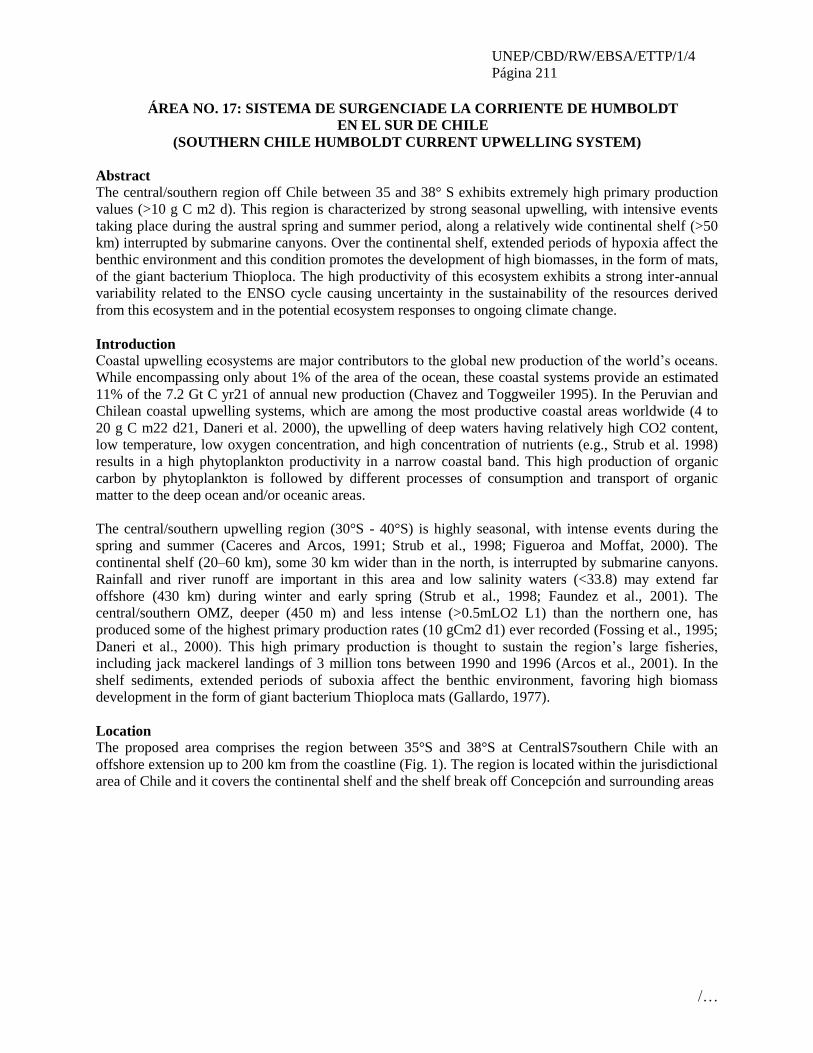
UNEP/CBD/RW/EBSA/ETTP/1/4
Página 211
/…
ÁREA NO. 17: SISTEMA DE SURGENCIADE LA CORRIENTE DE HUMBOLDT
EN EL SUR DE CHILE
(SOUTHERN CHILE HUMBOLDT CURRENT UPWELLING SYSTEM)
Abstract
The central/southern region off Chile between 35 and 38° S exhibits extremely high primary production
values (>10 g C m2 d). This region is characterized by strong seasonal upwelling, with intensive events
taking place during the austral spring and summer period, along a relatively wide continental shelf (>50
km) interrupted by submarine canyons. Over the continental shelf, extended periods of hypoxia affect the
benthic environment and this condition promotes the development of high biomasses, in the form of mats,
of the giant bacterium Thioploca. The high productivity of this ecosystem exhibits a strong inter-annual
variability related to the ENSO cycle causing uncertainty in the sustainability of the resources derived
from this ecosystem and in the potential ecosystem responses to ongoing climate change.
Introduction
Coastal upwelling ecosystems are major contributors to the global new production of the world’s oceans.
While encompassing only about 1% of the area of the ocean, these coastal systems provide an estimated
11% of the 7.2 Gt C yr21 of annual new production (Chavez and Toggweiler 1995). In the Peruvian and
Chilean coastal upwelling systems, which are among the most productive coastal areas worldwide (4 to
20 g C m22 d21, Daneri et al. 2000), the upwelling of deep waters having relatively high CO2 content,
low temperature, low oxygen concentration, and high concentration of nutrients (e.g., Strub et al. 1998)
results in a high phytoplankton productivity in a narrow coastal band. This high production of organic
carbon by phytoplankton is followed by different processes of consumption and transport of organic
matter to the deep ocean and/or oceanic areas.
The central/southern upwelling region (30°S - 40°S) is highly seasonal, with intense events during the
spring and summer (Caceres and Arcos, 1991; Strub et al., 1998; Figueroa and Moffat, 2000). The
continental shelf (20–60 km), some 30 km wider than in the north, is interrupted by submarine canyons.
Rainfall and river runoff are important in this area and low salinity waters (<33.8) may extend far
offshore (430 km) during winter and early spring (Strub et al., 1998; Faundez et al., 2001). The
central/southern OMZ, deeper (450 m) and less intense (>0.5mLO2 L1) than the northern one, has
produced some of the highest primary production rates (10 gCm2 d1) ever recorded (Fossing et al., 1995;
Daneri et al., 2000). This high primary production is thought to sustain the region’s large fisheries,
including jack mackerel landings of 3 million tons between 1990 and 1996 (Arcos et al., 2001). In the
shelf sediments, extended periods of suboxia affect the benthic environment, favoring high biomass
development in the form of giant bacterium Thioploca mats (Gallardo, 1977).
Location
The proposed area comprises the region between 35°S and 38°S at CentralS7southern Chile with an
offshore extension up to 200 km from the coastline (Fig. 1). The region is located within the jurisdictional
area of Chile and it covers the continental shelf and the shelf break off Concepción and surrounding areas
UNEP/CBD/RW/EBSA/ETTP/1/4
Página 212
/…
Fig.1
The
Coas
tal Upwelling System in the Southern Humboldt Current, indicating the oceanographic monitoring
stations.
Feature description of the proposed area
Feature condition and future outlook of the proposed area
Assessment of the area against CBD EBSA Criteria
CBD EBSA
Criteria
(Annex I to
decision
IX/20)
Description
(Annex I to decision IX/20) Ranking of criterion relevance
Don’t
Know
Low Some High
Uniqueness
or rarity
Area contains either (i) unique (“the only one of its
kind”), rare (occurs only in few locations) or
endemic species, populations or communities,
and/or (ii) unique, rare or distinct, habitats or
ecosystems; and/or (iii) unique or unusual
geomorphological or oceanographic features.
X
Explanation for ranking
The fertilizing effect of strong seasonal upwelling combined with large inputs of nutrients from winter
runoff (Sobarzo et al., 2007) and rivers generates a unique coastal ecosystem in terms of productivity and
habitat compartments characterized by year-round productivity (Montero et al., 2007). and presence of a
mosaic of estuarine, hypoxic, shallow and deep-sea habitats (Vargas et al., 2007). This mosaic provides
substrate and nourishments for a variety of organisms from microbes to higher vertebrates. This area also
contains a very unique system in the shelf break where endemic and novelty benthic communities have
evolved associated with methane hydrates environments. At least two new species of mollusk have recently
been described.
UNEP/CBD/RW/EBSA/ETTP/1/4
Página 213
/…
Special
importance
for life-
history stages
of species
Areas that are required for a population to survive
and thrive. X
Explanation for ranking
Many fish populations and invertebrates can complete successfully their life cycles by using the estuarine
habitats for key life stages, such as eggs, larvae and juveniles (Castro et al., 2000, Escribano and Morales
2012).
Importance
for
threatened,
endangered
or declining
species
and/or
habitats
Area containing habitat for the survival and
recovery of endangered, threatened, declining
species or area with significant assemblages of
such species.
X
Explanation for ranking
The strong human pressure on this ecosystem from industrial activities , and urban settlements may indicate
the potential for threats for some key species
Vulnerability,
fragility,
sensitivity, or
slow recovery
Areas that contain a relatively high proportion of
sensitive habitats, biotopes or species that are
functionally fragile (highly susceptible to
degradation or depletion by human activity or by
natural events) or with slow recovery.
X
Explanation for ranking
The dependence of river inputs and rainfall for coastal production during the non-upwelling season
(Sobarzo et al., 2007; Vargas et al., 2007) and the increasing human intervention in the coastal zone rise
strong concern of how anthropogenic activities may impact this ecosystem. Also, this ecosystem may be
strongly impacted by natural perturbations, such El Niño and the it seems that recovering from perturbations
at least in the benthic system takes longer than in other upwelling regions (Escribano et al., 2004).
The impact of ongoing climate change on this ecosystem is also uncertain, but it raises concern upon recent
evidence that upwelling is gradually increasing in this region (Falvey and Garreaud, 2009) rising the mixed
layer with unknown ecological consequences (Bakun et al, 2010).
Biological
productivity
Area containing species, populations or
communities with comparatively higher natural
biological productivity.
X
Explanation for ranking
Some of the highest values of primary production for upwelling systems have been measured over the
continental shelf of this zone, >20 g C/m2 d (Montero et al., 2007)
Biological
diversity
Area contains comparatively higher diversity of
ecosystems, habitats, communities, or species, or
has higher genetic diversity.
X
Explanation for ranking
Comparatively, this ecosystem exhibit low biodiversity and high dominance of many components of th
benthic and pelagic system (Escribano et al., 2003; Hidalgo et al., 2010, Riquelme-Bugueño et al., 2012).
Naturalness Area with a comparatively higher degree of X

UNEP/CBD/RW/EBSA/ETTP/1/4
Página 214
/…
naturalness as a result of the lack of or low level of
human-induced disturbance or degradation.
Explanation for ranking
As compared to other systems, this region may not reflect much naturalness, because of strong influences
from human activities in terms of industry, fishery and urban settlements
References
Cáceres, M., Arcos, D.F., 1991. Varibilidad en la estructura espacio-temporal de un area
de surgencia frente a la costa de Concepción, Chile. Investigación Pesquera (Chile) 36,
27–38.
CHAVEZ, F. P., AND J. R. TOGGWEILER. 1995. Physical estimates of global new
production: The upwelling contribution, p. 313–320. In C. P. Summerhayes, K. C. Emeis,
M. V. Angel, R. L. Smith and B. Zeitzschel [eds.], Upwelling in the ocean: Modern
processes and ancient records. Wiley.
DANERI, G., V. DELLAROSSA, R. QUIN˜ ONES, B. JACOB, P.MONTERO, AND O.
ULLOA. 2000. Primary production and community respiration in the Humboldt Current System
off Chile and associated oceanic areas. Mar. Ecol. Prog. Ser. 197: 41–49.
Escribano, R. and Schneider, W. (2007) The structure and functioning of the coastal upwelling
system off central/south of Chile. Prog. Oceanogr., 75, 343–346.
Escribano, R., Ferna´ndez, M. and Aranís, A. (2003) Physical-chemical processes and patterns of
diversity of the Chilean eastern boundary pelagic and benthic marine ecosystem: an overview.
Gayana, 67, 190–205.
Escribano, R., Daneri, D., Farı´as, L. et al. (2004) Biological and chemical consequences of the
1997-98 El Nin˜o in the Chilean coastal upwelling system: a synthesis. Deep-Sea Res. II, 51,
2389–2411.
Escribano, R., Morales, C.E., 2012. Spatial and temporal scales of variability in the coastal
upwelling and coastal transition zone off central-southern Chile (35-40°S). Progress in
Oceanography 92-95, 1-7.
Figueroa, A.D., Moffat, C., 2000. On the influence of topography in the induction of coastal
upwelling along the Chilean coast. Geophysical Research Letters 27, 3905–3908.
Faúndez, P.B., Morales, C.E., Arcos, D., 2001. Variabilidad espacial y temporal en la hidrografı´a
invernal del sistema de bahı´as frente a la VIII regio´ n (Chile centro-sur). Revista Chilena de
Historia Natural 74, 817–831.
Fossing, H., Gallardo, V.A., Jorgensen, B.B., Huttel, M., Nielsen, L.P., Schultz, H., Canfield, D.,
Forster, S., Glud, R.R., Gundersen, J.K., Ramsing, N.B., Teske, A., Thamdrup, B., Ulloa, O.,
1995. Concentration and transport of nitrate by the mat-forming sulphur bacterium Thioploca.
Nature 374, 713–715.
Gallardo, V.A., 1977. Large benthic microbial communities in sulfide biota under Peru–Chile
subsurface countercurrent. Nature 268, 331–332.
Montero, P., Daneri, G., Cuevas, L. A. et al. (2007) Productivity cycles in the coastal upwelling
area off Concepcion: the importance of diatoms and bacterioplankton in the organic carbon flux.
Prog.
Oceanogr., 75, 518–530.
UNEP/CBD/RW/EBSA/ETTP/1/4
Página 215
/…
Sobarzo, M., Bravo, L., Donoso, D. et al. (2007) Coastal upwelling and seasonal cycles that
influence the water column over the continental shelf off central Chile. Prog. Oceanogr., 75, 363–
382.
STRUB, P. T., J. M. MESIAS, V. MONTECINO, J. RUTLLAND, AND S. SALINAS. 1998.
Coastal ocean circulation off Western South America, p. 273–313. In A. R. Robinson and K. H.
Brink[eds.], The sea, vol. 11. Wiley.
Riquelme-Bugueño, R., Nuñez, S., Jorquera, E., Valenzuela, L., Escribano, R., Hormazabal, S.
2012. The influence of upwelling variation on the spatially-structured euphausiid community off
central/southern Chile. Progress in Oceanography 92-95, 146-165.
Vargas, C., Martı´nez, R., Cuevas, L. et al. (2007) The relative importance of microbial and
classical food webs in a highly productive coastal upwelling area. Limnol. Oceanogr., 52, 1495–
1510.

UNEP/CBD/RW/EBSA/ETTP/1/4
Página 216
/…
Maps and Figures
UNEP/CBD/RW/EBSA/ETTP/1/4
Página 217
/…
ÁREA NO. 18: DORSAL DE NAZCA Y DE SALAS Y GÓMEZ
(SALAS Y GÓMEZ AND NAZCA RIDGES)
Introduction:
The area proposed covers pelagic through hadal depth zones in the Salas y Gómez and Nazca submarine
ridges, which are two sequential chains of submarine mountains of volcanic origin located in the
Southeastern Pacific Ocean, jointly extending over 2,900 km. The Salas y Gómez ridge lies in a west-east
orientation. Its western end intersects the East Pacific Rise inside the Chilean Exclusive Economic Zone
(EEZ) of the Easter Islands and its eastern end adjoins the western end of Nazca ridge. The Nazca ridge
spreads in a southwest-northeastern direction. Its southern end includes part of the Chilean EEZ of San
Felix Island, while its northern end meets the Peru-Chile subduction zone inside the Peruvian EEZ.
The area beyond national jurisdiction covers about 415,638 km2, which represent approximately 1.68%
of the international waters surface in the FAO area No. 87. Further, it contains about 110 seamounts with
summits between the sea surface level and 2,000 m depth (fishable depths), which represent some 41% of
the seamounts in the Southeastern Pacific Ocean. The area is a biological hotspot with one of the highest
levels of marine biological endemism (41.2% in fishes and 46.3% in invertebrates) in the World. It is
considered a stepping stone for some marine mammals (e.g., blue whale, Rodrigo Hucke-Gaete personal
communication). And it has been identified as part of the forage area for Leatherback turtle. In addition, it
has been described as recruitment and nursery area for swordfish and it is part of the breeding zone
described for Chilean jack mackerel, overexploited specie. Until now the area has been subject of minor,
localized and sporadic activities, like bottom fishing and geological surveys and, therefore, a high degree
of naturalness is expected for many seamounts into the area.
Location:
Salas y Gomez ridge is located between 23°42’ S and 29°12’ S and 111°30’ W and 86°30’ W. Nazca
ridge is located between 15°00’ S and 26°09’ S and 86°30’ W and 76°06’ W. Both ridges include a
portion of the Chile EEZ: the former spread into the EEZ of Eastern Island and Salas y Gomez Island and
Nazca spread into the EEZ of Desventuradas Islands.
Feature description of the proposed area:
The Nazca area is influenced slightly by the eastern boundary currents of the South Pacific anticyclonic
gyre. The Chile current carries subantarctic water north, along the coast of Chile towards the equator,
along the coast of Chile. At approximately 20° S, influenced by the southeast trade winds and coastal
configuration, the current turns westward, away from the coast influencing Nazca area with nutrient-rich
waters (Galvez, 2009).
The Salas y Gómez and Nazca ridges are a long chain of tall seamounts and guyots that vary greatly in
depth, and are isolated from the nearest continental margin by a deep trench (Parin etal., 1997). The ridge
area beyond national jurisdiction contains about 110 seamounts with summits at fishable depths down to
2’000 m, representing 41% of the seamounts in the south-eastern Pacific Ocean. The benthic and
benthopelagic invertebrates and fishes of the area are much more closely related to the Indo-West Pacific
than to the eastern Pacific fauna.
Currently, 226 species of benthic and benthopelagic invertebrates and 171 fish species of 64 genera are
known to inhabit the 22 explored seamounts of the ridges (Parin et al., 1997). Considering the overall
number of seamounts in the region, many more species can be expected. Further, the bottom areas of

UNEP/CBD/RW/EBSA/ETTP/1/4
Página 218
/…
Salas y Gómez and Nazca ridges have not been sampled biologically. The area is a biodiversity hotspot
with one of the highest levels of marine biological endemism, amounting to 41.2% of fish species and
46.3% of benthic invertebrates (Parin et al., 1997; Mironov et al., 2006) even surpassing the rates for
hydrothermal vent ecosystems (Richer de Forges et al., 2000).
The ridges offer habitat to a number of low resilience and long-lived species like deep water sharks (Parin
and Kotlyar, 2007), oreos, alfonsino, and reefbuilder corals (e.g., Madrepora oculata). They are likely to
be speciation centers and provide the only extensive hard substrate available for propagation of benthic
suspension feeders like black (Antipatharia) and stony corals (Scleractinia), of which at least 19 genera
have been recorded, with many more species (Mironov et al., 2006).
The seamounts of the ridges were found to host aggregations of vertically migrant, seamount-associated
mesopelagic fishes and migratory pelagic fishes: Pelagic sharks, in particular schools of large (2 - 3 m
TL) adult male blue sharks have been observed to aggregate over Nazca ridge. Also bigeye thresher
sharks (Alopias superciliosus) were more abundant over seamounts than in the surroundings (Litvinov,
1989). The ridges function as recruitment and nursery areas for swordfish (Xiphias gladius) (Yañez et al.,
2004, 2006, 2009) and are part of the breeding zone described for Chilean jack mackerel (Trachurus
murphyi) (Arcos et al., 2001; Anon., 2007).
The high pelagic productivity indicated by the formation of Taylor caps and local upwelling processes
observed over the Nazca Ridge may support blue whales (Balaenoptera musculus), for which it is
considered to be a likely reproductive zone and stepping stone during their extensive migrations (Hucke-
Gaete and Mate, 2005). Salas y Gómez ridge is located at the center of the foraging area for leatherback
sea turtles (Dermochelys coriacea) in the South Pacific Gyre (Shillinger, 2008) and, based on that, it has
been postulated as ecologically or biologically significant marine area by Duke University and TOPP.
Deepwater commercial species and the occurrence of vulnerable benthic species coincide to a large
extent. There are indications of abundant mega- and macrofauna bycatch in trawls, including large
branches of gorgonians. Between 1979/80 and 1987 significant changes in the benthic communities such
as loss of antipatharian corals were observed in consequence of bottom trawling (Parin et al., 1997).
Feature condition and future outlook of the proposed area
Based on satellite tracking of blue whales, Nazca ridge has been postulated as the likely reproductive
zone for blue whale sub-population feeding in Corcovado Gulf (Southern Chile), but in situ research must
be carried out to test such hypothesis. On Salas y Gómez ridge, most of the fishing activity carried out is
pelagic (Vega etal., 2009). There has been historical fishing targeting jack mackerel, tunas and swordfish,
but information from SPRFMO and IATTC should be available to conduct analyses in that sense. The
area is likely to be on the route of cargo ships that transit between Asia Pacific countries and Chilean
ports; therefore, strikes with whales may occur.
UNEP/CBD/RW/EBSA/ETTP/1/4
Página 219
/…
Assessment of the area against CBD EBSA Criteria
CBD EBSA
Criteria
(Annex I to
decision
IX/20)
Description
(Annex I to decision IX/20) Ranking of criterion relevance
Don’t
Know
Low Some High
Uniqueness or
rarity
Area contains either (i) unique (“the only one of its
kind”), rare (occurs only in few locations) or
endemic species, populations or communities, and/or
(ii) unique, rare or distinct, habitats or ecosystems;
and/or (iii) unique or unusual geomorphological or
oceanographic features
X
Explanation for ranking
The seamounts of N&SG are unique in that they constitutes a biogeographical province much more closely
related to the Indo-West Pacific than to the eastern Pacific. Findings in the area shown high endemism rates,
reached to 41.2% in fishes and 46.3% in invertebrates associated to the bottom (Parin etal., 1997; Mironov
etal., 2006). These endemism rates are the higher found in seamounts, and surpass rates of ecosystems
associated with hydrothermal vents, one of the most isolated in the Ocean (Richer de Forges etal., 2000).
These ridges have 15 out of 94 seamounts in shallow water and has a high proportion of the total number of
shallow seamounts in the region and met the criteria for unique habitats (Dunstan etal., 2011).
Special
importance
for life-history
stages of
species
Areas that are required for a population to survive
and thrive X
Explanation for ranking
Nazca ridge and the eastern end of Salas y Gomez ridges are considered to be the main recruitment area for
Chilean jack mackerel and a nursery zone for swordfish (Yañez etal., 2004, 2006). Almost half of all
invertebrates recorded live in those seamounts; therefore, the habitat provided by these seamounts is required
for invertebrate populations to survive and thrive. It provides the only extensive hard substrate available for
propagation of benthic suspension feeders like Antipatharians and Scleractinians.
On isla Sala y Gomez three species of seabird breed in internationally significant numbers and the site
qualifies as an Important Bird Area (IBA) according to BirdLife criteria. Christmas Island Shearwater
(Puffinus nativiatis), White-throated Storm-petrel (Nesofregetta fuliginosa) and Masked Booby (Sula
dactylatra). BirdLife International (2012b). Isla San Felix and isla Ambrosio also hold internationally
important seabird colonies, with both qualifying as IBA. Defilippi’s Petrel (Pterodroma defilippiana) is the
species of greatest importance, with over 10,000 pairs known to occur, and is an endemic breeder to Chile,
only occurring elsewhere on the Juan Fernandez Islands. BirdLife International (2012b).
While no tracking data exists for these species, and many are highly pelagic potentially travelling up to 500
km on a single foraging trip, the area included in this area will include a large proportion of their feeding
areas used during the breeding season. Data collected from tracking devices shows that the area north of Islas
San Felix and Ambrosio is used by the Chatham Petrel (Pterodroma axillaris), which migrates here from
New Zealand to feed in its non-breeding season during the months of June to September. (Rayner et al 2012)
Importance
for threatened,
Area containing habitat for the survival and recovery
of endangered, threatened, declining species or area X

UNEP/CBD/RW/EBSA/ETTP/1/4
Página 220
/…
endangered or
declining
species and/or
habitats
with significant assemblages of such species.
Explanation for ranking
Much of the fauna recorded in Nazca and Salas y Gomez ridges is endemic to their seamounts. Therefore,
due the scarce information most of benthic or benthopelagic species inhabiting these ridges are not evaluated
in their status or are data deficient classified in the IUCN Red List.
However, the ridges offer habitat for a number of low resilient and long-living species like deep water sharks
(Parin and Kotlyar, 2007), oreos, alfonsino, and reef-builder coral (e.g., Madrepora oculata). If these species
are adversely affected they may easily become threatened.
Satellite tracking has recorded the presence and persistence of blue whales and leatherback turtles, both
threatened species. The IUCN RedList includes Defilippi’s Petrel as Vulnerable, Chatham Petrel as
Endangered and the White-throated Storm-petrel as Vulnerable (BirdLife International, 2012a).
Vulnerability,
fragility,
sensitivity, or
slow recovery
Areas that contain a relatively high proportion of
sensitive habitats, biotopes or species that are
functionally fragile (highly susceptible to
degradation or depletion by human activity or by
natural events) or with slow recovery.
X
Explanation for ranking
In particular deep water species and biogenic habitats such as formed by cold water corals and sponges are
considered vulnerable (Koslow, 2007), as often fragile, and slow (if at all) to recover due to slow growth,
retarded maturity and high generation length, as well as population characteristics of high diversity at low
biomass.
Please see below for illustration:
“Significant changes were noted between 1979-1980 and 1987 in the structure of bottom communities.
Antipatharians were destroyed by the bottom otter-trawl […], and [cirripedes] were lost with their
substratum animals, [while] populations of sea urchin [, who feed over cirripedes,] declined following the
destruction” (Parin etal., 1997: 178)
All seabirds are long lived (several decades) and slow at reproducing (normally 1 chick a year, and often
taking several years to reach maturity) making them vulnerable and slow to recover following declines.
Biological
productivity
Area containing species, populations or communities
with comparatively higher natural biological
productivity.
X
Explanation for ranking
Daneri etal (2000) have shown strong evidence that may support the formation of Taylor columns over the
seamounts of Nazca ridge, and the occurrence of local upwelling process in Nazca area, making this area
particularly more productive than the surrounding South-eastern Pacific Ocean.
The Nazca area is slightly influenced by the eastern boundary currents of the South Pacific anticyclonic gyre.
The Chile Current arises in the Subantarctic region. Thus, it carries “equatorward”, along the coast of Chile,
Subantarctic Water. When it reaches approximately 20° S, influenced by the southeast trade winds and
coastal configuration, turns westward, away from the coast influencing Nazca area with rich nutrients waters
(Galvez, 2009).
Biological Area contains comparatively higher diversity of X
UNEP/CBD/RW/EBSA/ETTP/1/4
Página 221
/…
diversity ecosystems, habitats, communities, or species, or has
higher genetic diversity.
Explanation for ranking
Few comprehensive studies have been conducted on the N&SG ridges. Taking into account only the Russian
research, we know that 192 species of benthopelagic and benthic invertebrates and 171 species of fishes
inhabit the 22 explored seamounts of the Nazca and Salas y Gomez ridges (Parin etal., 1997). If we consider
that the area comprise at least 110 seamounts, then we can expect to discover a much higher biodiversity. It
is important to note that the bottom of Nazca and Salas y Gomez ridges has not been biologically sampled.
Elevations and depths ranging from abyssal soft sediment plains and trenches to the hard bottom peaks of
seamounts and hills on the ridges may provide for an extensive range of ecological niches. Preliminary
information on research done in 2011 shows that new species and high biological diversity were found in
Salas y Gomez ridge close to Salas y Gomez island (National Geographic and Oceana, 2011)
Naturalness Area with a comparatively higher degree of
naturalness as a result of the lack of or low level of
human-induced disturbance or degradation.
X
Explanation for ranking
Only the former URSS scientific expeditions and Chilean bottom trawling fleet were known to bottom fish in
this area (Galvez, 2009) There are indications that big branches of gorgonias were destroyed by trawlers
(Parin etal., 1997). However, from beyond fishing depth, no significant human impacts are known. In sum,
the area has been lightly fished with only 12 seamounts with reported fishing activity, so naturalness is
reasonably high (Dunstan etal., 2011). In the case of Salas y Gomez ridge, most of the fishing activity carried
out is on pelagic layer on tuna and swordfish (Vega etal., 2009).
References
Anon., 2007. Report from Chile on jack mackerel research and stock assessment. Paper
SPRFMO-III-SWG-18 presented at Third Scientific Working Group of South pacific Regional
Fisheries Organisation, 25-27 April 2007 in Reñaca, Chile.
http://www.southpacificrfmo.org/third-swg-meeting/
Arcos, D., L. Cubillos & S. Nuñez. 2001. The jack mackerel fishery and El Niño 1997-1998
effects off Chile. Progress in Ocenography, 49(1), 597-617.
BirdLife International (2012a) IUCN Red List for birds. Downloaded from
www.birdlife.org/datazone/species/search on 29/08/2012
BirdLife International (2012b) Important Bird Areas factsheet. Downloaded from
www.birdlife.org/datazone/site/search on 29/08/2012
Clark, J.G. & J. Dymond. 1977. Geochronology and petrochemistry of Easter and Sala y Gómez
islands; implications for the origin of the Sala y Gómez Ridge. J. Volcanol. Geoth. Res., 2(1), 29-
48.
Daneri, G., V. Dellarossa, R. Quiñones, B. Jacob, P. Montero & O. Ulloa. 2000. Primary
production and community respiration in the Humboldt current system off Chile and associated
oceanic areas. Mar. Ecol. Prog. Ser., 197, 41-49.
Dunstan, P.K., M.R. Clark, J. Guinotte, T. O’Hara, E. Niklitschek, A.A. Rowden, T. Schlacher, S.
Tsuchida, L. Watling, & A. Williams. 2011. Identifying Ecologically and Biologically Significant
Areas on Seamounts. Gland, Switzerland: IUCN. 14 pp. http://data.iucn.org/dbtw-
wpd/edocs/2011-056.pdf
UNEP/CBD/RW/EBSA/ETTP/1/4
Página 222
/…
Gálvez, M. 2009. Seamounts of Nazca and Salas y Gómez: a review for management and
conservation purposes. Lat. Am. J. Aquat. Res., 37(3), 479-500.
http://www.scielo.cl/pdf/lajar/v37n3/art16.pdf
Hucke-Gaete, R. & B. Mate. 2005. Feeding season movements and fall migration to wintering
areas for Chilean blue whales. Abstracts of the 16th Biennial Conference on the Biology of
Marine Mammals, 12-16 December 2005, San Diego, CA, USA.
Koslow, T. 2007. The silent deep: the discovery, ecology and conservation of the deep sea.
Chicago. The University of Chicago Press, Chicago, 270 pp.
Litvinov, F.F. 1989. Struktura epipelagicheskogo taksocena Elasmobranchii v Atlanticheskom i
Tikhom okeanakh i ee izmeneniya v noveyshee geologicheskoe vremya. Voprosy Ikhtyologii, 29,
973–984.
Mironov, A.N., T.N. Molodtsova & N.V. Parin. 2006. Soviet and Russian studies on seamount
biology. Presentation at the International Seabed Authority workshop on Cobalt-Rich Crusts and
the Diversity and Distribution Patterns of Seamount Fauna.
http://www.isa.org.jm/en/scientific/workshops/2006/Mar06.
National Geographic & Oceana. 2011. Expedición a Isla de Pascua y Salas y Gómez, Febrero –
Marzo 2011.Informe Científico.
http://oceana.org/sites/default/files/reports/Informe_IPySG_final.pdf
Parin, N.V., A.N. Mironov & K.N. Nesis. 1997. Biology of the Nazca and Sala y Gómez
submarine ridges, an outpost of the Indo-West Pacific fauna in the Eastern Pacific Ocean:
composition and distribution of the fauna, its communities and history. In: A.V. Gebruk et al.
(ed.). The biogeography of the oceans. Adv. Mar. Biol., 32, 145-242.
Parin, N.V. and A. N. Kotlyar. 2007. On Finding of Shark of the Genus Somniosus (Squalidae) at
the Submarine Ridge of Nazca (Southeastern Pacific). Journal of Ichthyology, 47(8), 669–672.
Rayner, M. J.; Taylor, G. A.; Gummer, H. D.; Phillips, R. A.; Sagar, P. M.; Shaffer, S. A.;
Thompson, D. R. 2012. The breeding cycle, year-round distribution and activity patterns of the
endangered Chatham Petrel (Pterodroma axillaris). Emu.
Richer de Forges, B.; J.A. Koslow & G.C.B. Poore. 2000. Diversity and endemism of the benthic
seamount fauna in the southwest Pacific. Nature, 405, 944–947.
Vega, R., R. Licandeo, G. Rosson & E. Yáñez. 2009. Species catch composition, length structure
and reproductive indices of swordfish (Xiphias gladius) at Easter Island zone. Lat. Am. J. Aquat.
Res., 37(1), 83-95. http://www.scielo.cl/pdf/lajar/v37n1/art07.pdf
Yáñez, E., C. Silva, J. Marabolí, F. Gómez, N. Silva, E. Morales, A. Bertrand, J. Campalans, A.
Gamonal, J. Chong, P. Rojas, B. Menares & J.I. Sepúlveda. 2004. Caracterización ecológica y
pesquera de la Cordillera de Nazca como área de crianza del pez espada. Informe Final Proyecto
FIP N° 2002-04: 388 pp.
Yáñez, E., C. Silva, N. Silva, A. Ordenes, F. Leiva, P. Rojas, J. Chong, J. Campalans, S. Palma,
G. Claramunt, C. Oyarzún, R. Meléndez & R. Vega. 2006. Caracterización ecológica y pesquera
de Cordillera de Nazca como área de crianza del pez espada. Fase II. Informe Final Proyecto FIP
2004-34: 236 pp.
Yáñez, E., C. Silva, M. Barbieri1, A. Órdenes & R. Vega. 2009. Environmental conditions
associated with swordfish size compositions and catches off the Chilean coast. Lat. Am. J. Aquat.
Res., 37(1), 71-81. http://www.lajar.cl/pdf/imar/v37n1/Articulo_37_1_6.pdf
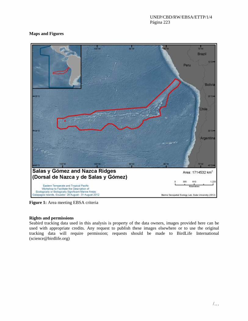
UNEP/CBD/RW/EBSA/ETTP/1/4
Página 223
/…
Maps and Figures
Figure 1: Area meeting EBSA criteria
Rights and permissions
Seabird tracking data used in this analysis is property of the data owners, images provided here can be
used with appropriate credits. Any request to publish these images elsewhere or to use the original
tracking data will require permission; requests should be made to BirdLife International

UNEP/CBD/RW/EBSA/ETTP/1/4
Página 224
/…
ÁREA NO. 19: MONTES SUBMARINOS EN EL CORDÓN DE JUAN FERNÁNDEZ
(JUAN FERNANDEZ RIDGE SEAMOUNTS)
Resumen
Los montes submarinos constituyen ecosistemas marinos vulnerables de gran importancia ecológica y
biológica (Dunstan, et al., 2011; FAO 2009). Se han identificado y caracterizado 118 montes en las
distintas ZEE de Chile. Adicionalmente, en los montes Juan Fernández 1 y 2 (JF1, JF2) se he levantado
información oceanográfica y biológica (fitoplancton, zooplancton, invertebrados y pesca exploratoria con
diversos artes) (Yañez, et al., 2006). Información histórica indica que JF1 y JF2 se han capturado un total
de 82 especies, destacándose la presencia de corales negros en trampas langosteras. Fotografías
submarinas de los montes JF1 y JF2 presentan características atribuibles al impacto de artes de arrastre de
fondo. El esfuerzo de pesca se ha realizado mayormente en JF2 (4.667 km arrastrados). El esfuerzo de
pesca mensual se incrementó considerablemente durante el 2002, 2003 y 2005, alcanzando valores sobre
500 km arrastrados, modificando la estructura espacial de las agregaciones de recursos en el monte JF2
Introducción
Uno de los objetivos del actual enfoque internacional de conservación de la biodiversidad marina es la
identificación y protección de áreas discretas, definidas a partir de la representatividad de los ecosistemas
presentes en ellas y/o de su rol como hábitat esencial para la conservación de especies vulnerables o
amenazadas. De este modo, la demanda internacional por identificar y priorizar posibles áreas marinas
protegidas en los montes submarinos chilenos requiere de un mínimo conocimiento de la estructura y
singularidad de las comunidades allí presentes, y del rol que cumplen esas áreas en el ciclo de vida de
especies identificadas como sujetos especiales de conservación.
El proyecto FIP 2006-57 permitió generar información relevante sobre aspectos ambientales, ecológicos y
biológicos de los montes submarinos en aguas chilenas (Yáñez et al., 2008, 2009). Se cuenta con
imágenes satelitales topográficas junto con la información geográfica, nombres asignados y principales
dimensiones (área superficial, profundidad) de 118 montes submarinos localizados en aguas de la ZEE
chilena, dentro de las sub-áreas FAO 87.2 y 87.3. El área de estudio correspondiente a las ZEE de Chile
continental e insular es dividida en 7 zonas para facilitar el proceso, análisis e interpretación de los datos:
norte, centro, sur, sur austral, San Felix, Juan Fernández e isla de Pascua (Fig. 1).
Se cuenta con bases datos digitales históricas de la biodiversidad de los principales montes submarinos
asociados a la ZEE continental e insular de Chile (Tabla 1).
Se dispone esfuerzo pesquero aplicado a los montes submarinos de la ZEE de Chile en años recientes
(Tabla 2 y Figura 2)
Se dispone de información sobre evaluación directamente (in situ) de la biodiversidad bentónica y
demersal de dos (JF1 y JF2) de montes submarinos identificados como prioritarios de estudiar debido a su
alta explotación: fitoplancton (Tabla 3), zooplancton (Tabla 4), invertebrados (Tabla 5) y peces y
crustáceos.
Se cuenta con la información de características ambientales y oceanográficas de los montes submarinos
JF1 y JF2: 1) datos in situ: temperatura, salinidad y oxígeno disueltos en profundidad, 2) datos satelitales:
anomalía de la altura superficial del mar y corrientes geostróficas, magnitud y dirección de vientos
superficiales del mar, temperatura superficial del mar, salinidad superficial, concentración de clorofila a.
Ubicación

UNEP/CBD/RW/EBSA/ETTP/1/4
Página 225
/…
El área de estudio correspondiente a las ZEE de Chile continental e insular donde hay montes submarinos
y está dividida en 7 zonas: norte, centro, sur, sur austral, San Felix, Juan Fernández e Isla de Pascua (Fig.
1). No obstante, que se propone el estudio de todas las zonas de montes submarinos vulnerables como las
7 áreas descritas, se cuenta con información detallada sólo para los montes fuertemente explotados Juan
Fernández 1 y 2 (JF1, JF2).
Descripción de las características del área propuesta
Se identificaron 118 montes submarinos: 35 alrededor de isla de Pascua (25º-30°S; 105º-112°W), 21
cerca de isla San Félix (24°-29°S; 76°-84°W), 21 en la zona norte del país (18°-30°S; 71°-75°W), 15
alrededor del archipiélago de Juan Fernández (30°-35°S; 76°-82°W), 10 en la zona sur austral (50°-58°S;
70°-77° W ), 9 en la zona sur y (40°-50° S; 73°-79° W) y 8 en la zona central del país (30°-40°S; 71°-
76°W).
Al evaluar el área de los montes fuertemente explotados (JF1 y JF2) podemos hacer la siguiente
descripción de las características ambientales, ecológicas y biológicas de esta área marina. Los montes
submarinos JF1 y JF2 presentan un sustrato volcánico, principalmente constituido por escombros de roca
y arena. Estos se encontraron influenciados por las masas de agua subtropical (AST), subantártica
(ASAA), ecuatorial subsuperficial (AESS) e intermedia antártica (AIAA), aunque la influencia de AST y
AIAA es débil. La distribución vertical del oxígeno disuelto presentó una estructura de dos capas, una
superficial de alrededor de 100 m, bien oxigenada y con concentraciones mayores de 5 mL·L-1 (90-100%
de saturación), siendo relativamente cuasi homoóxica. Bajo esta capa, el oxígeno disuelto disminuyó
rápidamente a concentraciones menores de 1 mL·L-1 (5-20% saturación) alrededor de 200-300 m de
profundidad. En julio-agosto (invierno) se observó un leve frente de corriente con anomalías de
temperatura superficial del mar (TSM) negativas en JF1 y positivas en JF2. La TSM mostró una
condición fría característica de 10°-17°C, salinidad superficial de aproximadamente 34.3%o y
concentración de clorofila a entre 0.09 y 1 mg/m3. En tanto en noviembre-diciembre (primavera) se
observó una mayor cantidad de estructuras de mesoescalas, como giros y frentes de corrientes. La TSM
presentó una condición fría característica de la época, con valores de 13º-18°C, en tanto la salinidad
superficial fue cercana a 34.1%o y la concentración de clorofila a de alrededor de.4 mg/m3.
El fitoplancton sobre los montes submarinos explorados presentó 31 géneros, 23 especies y otros no
identificados: Acantharia (1), Bacillariophyceae (15), Cianophyceae (1), Ciliatea (19), Dictyochophyceae
(3) y Dinophyceae (18). En tanto que del zooplancton se identificaron 26.964 organismos, distribuidos en
16 grupos taxonómicos pertenecientes a los Phylum Cnidaria, Annelida, Chaetognatha, Arthropoda,
Tunicata y Vertebrata. El 88% de los organismos son quitinosos (eufáusidos, misidáceos, anfípodos,
ostrácodos, copépodos, cirripedios y larvas de crustáceos decápodos), el 11% gelatinosos y
semigelatinosos (medusas, sifonóforos, ctenofors, quetognatos, salpas, apendiculares y poliquetos) y el
1% restante a huevos y larvas de peces (Hygophum brunni y Sardinops sagax).
Los métodos de pesca utilizados permitieron la captura de dos especies pelágicas, tiburón azulejo
(Prionace glauca) y sierra (Thyrsites atun), dos demersales, chancharro (Helicolenus lengerichi) y
congrio de profundidad (Pseudoxenomystax nielseni), y dos crustaceos, cangrejo dorado (Chaceon
chilensis) y la centolla de Juan Fernández (Paromola rathbuni). Los invertebrados que se recolectan con
rastra son 409 y represen grupos importantes, como Echinoidea (Echinacea), Polychaeta, Porifera,
Actinaria y Asteroidea. Diferentes muestras fueron enviadas a laboratorios de especialistas nacionales y
extranjeros, para la identificación a nivel de especie. Por otra parte, la revisión bibliográfica permitió
establecer que en las actividades pesqueras del 2001-2006, en los montes JF1 y JF2, se capturaron 82
especies pertenecientes a 4 Phylum (Chordata, Arthropoda, Mollusca y Echinodermata), destacándose las
familias Macrouridae (9), Moridae (6) y Dalatiidae (4).
Las fotografías submarinas del sustrato marino de JF1 y JF2 presentan características que atribuibles al
impacto de artes de arrastre de fondo (Fig. 2). Esto concuerda con la información proveniente de la flota

UNEP/CBD/RW/EBSA/ETTP/1/4
Página 226
/…
arrastrera, que muestra que la actividad se realiza principalmente sobre la parte plana y superficial de los
montes (Gálvez et al., 2006). Del análisis de esta información se desprende que el esfuerzo de pesca se
realizo mayormente en el monte JF2, alcanzando 4.667 km de arrastre, en comparación con los montes
JF1 y JF4, donde se registraron valores de 1.526 y 906 km de arrastre respectivamente. Sin embargo, el
índice relativo de pesca mostró valores altos para los montes JF4 y JF2, de 11,7 km-1 y 10,5 km-1
respectivamente. No así para el monte JF1, que con un alto de esfuerzo de pesca mostró un índice relativo
de pesca de 2,51 km-1 debido a su mayor área estimada en 608 km2.
El esfuerzo de pesca mensual se incremento considerablemente durante el 2002, 2003 y 2005, alcanzando
valores por sobre los 500 km de arrastre; luego decae considerablemente al final del periodo analizado
(2001-06), registrando los valores de inicio de la pesquería. Los altos valores observados del esfuerzo de
pesca modificaron la estructura espacial de las agregaciones de los recursos en el monte JF2. En el 2001
las agregaciones del monte JF2 presentaron una distribución espacial simétrica hasta los 4 km; sin
embargo, en el 2003 presentó un valor inferior al 1 km. La variabilidad espacial se vio afectada por una
disminución de la abundancia relativa de los principales recursos explotados en este monte, orange
roughy (Hoplostetbus atlanticus) y alfonsino (Beryx splendens).
La magnitud del conocimiento necesario para la adecuada conservación de la biodiversidad de montes
submarinos de la ZEE de Chile es enorme y el presente proyecto representa solo un paso orientado
incrementar la información disponible. Obviamente que la mayor preocupación dice relación con aquellas
áreas actualmente sometidas a explotación pesquera, donde se considera prioritario tomar medidas de
conservación y desarrollo de actividades sustentables.
Condición de las características y perspectivas a futuro de la zona propuesta
El esfuerzo de pesca se ha incrementado considerablemente en la década del 2000, modificando
significativamente la estructura espacial de las agregaciones de los recursos explotados, particularmente
orange roughy y alfonsino (Yáñez et al., 2009).
Por otra parte, fotografías submarinas del sustrato marino presentan características que pueden atribuirse
al impacto físico de artes de arrastre de fondo. Esto concuerda con la información operacional de la flota,
que muestra que la actividad se realiza preferentemente sobre la parte plana y superficial de los montes
(Yáñez et al., 2008).
Finalmente cabe señalar, que la reducida cantidad de especies que han sido obtenidas durante las
prospecciones efectuadas sobre los montes submarinos JF1 y JF2, se debió al sistema de muestreo
empleado, restringido a métodos no intrusivos por los Términos Básicos de Referencia del proyecto. Esto
impidió registrar con mayor exactitud el grado de endemismo de las especies presentes y determinar si
efectivamente se está frente a un ecosistema marino vulnerable. Por lo tanto, se recomienda realizar otro
proyecto de esta misma naturaleza, para lograr resultados más precisos y concluyentes.
Evaluación del área sobre los criterios EBSA del CDB
Criterios
CBD EBSA
(Anexo I de la
decisión IX/20)
Descripción
(Anexo I de la decisión IX/20) Clasificación de los criterios
pertinentes
No lo se Bajo Alguno Alto
Características
únicas, rarezas
Área de singularidad o rareza contiene ya sea
(i) exclusivas («la única de su clase"), raras
(sólo ocurre en pocos lugares) o de especies
endémicas, poblaciones o comunidades, y / o
(ii) único, raro o distinto, los hábitats o los
ecosistemas, y / o (iii) características
X

UNEP/CBD/RW/EBSA/ETTP/1/4
Página 227
/…
geomorfológicos u oceanográficos exclusivos
o desacostumbrados.
Explicación para la clasificación
De acuerdo a la fauna de invertebrados, Parin et al. (1997) postulan la provincia biogeográfica Salas y
Gomesian entre 83ºW y 101ºW, que se diferencia archipiélago de Juan Fernández. Por lo tanto, estos montes
submarinos tendrían una fauna de invertebrados distintiva.
Otro elemento distintivo del cordón de montes submarinos de Juan Fernandez es que el stock de Alfonsino y
orange roughy se encuentra principalmente en dichos montes, y escasamente en otros montes aislados.
Importancia
especial para
las etapas del
ciclo biológico
de especies
Las áreas requieren una población para
sobrevivir y prosperar.
X
Explicación para la clasificación
The species targeted by fisheries at seamounts of Juan Fernandez have a very low overall abundance, but
they aggregate at seamounts as part of their life cycle strategy, e.g. for spawning. They are long-lived, slow
growing, late maturing and have low reproductive potential.
Therefore if they are fished out, it is thought that it could be decades before these localised stocks recover;
particularly as they are thought to have limited exchange with other seamounts. This makes each seamount
very important for lifecycle of species (ICES, http://www.ices.dk/marineworld/seamounts.asp)
Importancia de
especies
amenazadas, en
peligro o en
declive y/o
hábitats
Áreas que contienen hábitat para la
supervivencia y recuperación de especies en
peligro, amenazadas, especies en declive o
área con agrupamientos significativos de tales
especies.
X
Explicación para la clasificación
El orange rouphy (Hoplosthetus atlanticus), Alfonsino (Beryx splendens) y bacalao de Juan Fernandez
(Polyprion oxigenois) son especies características de los montes submarinos de Juan Fernandez y
actualmente se encuentran severamente sobreexplotadas por la acción de la pesca. Igualmente, dichos
montes son hábitat para especies de corales negros de aguas frías, los que son frágiles a la perturbación
mecánica. Dado que estas especies se distribuyen preferentemente en estos montes, ellos se convierten en un
hábitat importante para que estas especies puedan persistir.
Vulnerabilidad,
fragilidad,
sensibilidad, o
Áreas de lenta
recuperación
Áreas que contengan una proporción
relativamente elevada de hábitats sensibles,
biotopos o especies que son funcionalmente lo
caul o agotamiento por actividades humanas o
por acontecimientos naturales) o con una lenta
recuperación.
X
Explicación para la clasificación
Seamount ecosystems have been highlighted by the United Nations General Assembly as vulnerable to
fishing (resolutions 61/105, and 59/25, United Nations 2006) and the Food and Agriculture Organization of
the UN has developed International Guidelines for the Management of deep-sea fisheries in the High Seas
(FAO 2009). Conservation needs for seamounts have been identified in recent years (e.g., Probert et al.
2007) including the need for a protected area system to protect seamount biodiversity, and ecosystem
structure and function (e.g., Johnston & Santillo 2004, George et al. 2007). Using underwater photography,
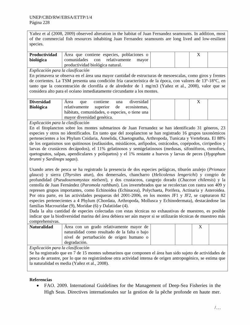
UNEP/CBD/RW/EBSA/ETTP/1/4
Página 228
/…
Yañez et al (2008, 2009) observed alteration in the habitat of Juan Fernandez seamounts. In addition, most
of the commercial fish resources inhabiting Juan Fernandez seamounts are long lived and low-resilient
species.
Productividad
biológica
Área que contiene especies, poblaciones o
comunidades con relativamente mayor
productividad biológica natural.
X
Explicación para la clasificación
En primavera se observa en el área una mayor cantidad de estructuras de mesoescalas, como giros y frentes
de corrientes. La TSM presenta una condición fría característica de la época, con valores de 13º-18°C, en
tanto que la concentración de clorofila a de alrededor de 1 mg/m3 (Yañez et al., 2008), valor que se
considera alto para el océano inmediatamente circundante a los montes.
Diversidad
Biológica
Área que contiene una diversidad
relativamente superior de ecosistemas,
hábitats, comunidades, o especies, o tiene una
mayor diversidad genética.
X
Explicación para la clasificación
En el fitoplancton sobre los montes submarinos de Juan Fernandez se han identificado 31 géneros, 23
especies y otros no identificados. En tanto que del zooplancton se han registrado 16 grupos taxonómicos
pertenecientes a los Phylum Cnidaria, Annelida, Chaetognatha, Arthropoda, Tunicata y Vertebrata. El 88%
de los organismos son quitinosos (eufáusidos, misidáceos, anfípodos, ostrácodos, copépodos, cirripedios y
larvas de crustáceos decápodos), el 11% gelatinosos y semigelatinosos (medusas, sifonóforos, ctenofors,
quetognatos, salpas, apendiculares y poliquetos) y el 1% restante a huevos y larvas de peces (Hygophum
brunni y Sardinops sagax).
Usando artes de pesca se ha registrado la presencia de dos especies pelágicas, tiburón azulejo (Prionace
glauca) y sierra (Thyrsites atun), dos demersales, chancharro (Helicolenus lengerichi) y congrio de
profundidad (Pseudoxenomystax nielseni), y dos crustaceos, cangrejo dorado (Chaceon chilensis) y la
centolla de Juan Fernández (Paromola rathbuni). Los invertebrados que se recolectan con rastra son 409 y
represen grupos importantes, como Echinoidea (Echinacea), Polychaeta, Porifera, Actinaria y Asteroidea.
Por otra parte, en las actividades pesqueras del 2001-2006, en los montes JF1 y JF2, se capturaron 82
especies pertenecientes a 4 Phylum (Chordata, Arthropoda, Mollusca y Echinodermata), destacándose las
familias Macrouridae (9), Moridae (6) y Dalatiidae (4).
Dada la alta cantidad de especies colectadas con estas técnicas no exhaustivas de muestreo, es posible
indicar que la biodiversidad marina del área debiera ser aún mayor si se utilizarán técnicas de muestreo más
comprehensivas.
Naturalidad Área con un grado relativamente mayor de
naturalidad como resultado de la falta o bajo
nivel de perturbación de origen humano o
degradación.
X
Explicación para la clasificación
Se ha registrado que en 7 de 15 montes submarinos que componen el área han sido sujeto de actividades de
pesca de arrastre, por lo que no registrándose otra actividad intensa de origen antropogénico, se estima que
la naturalidad es media (Yañez et al., 2008).
Referencias
FAO. 2009. International Guidelines for the Management of Deep-Sea Fisheries in the
High Seas. Directives internationales sur la gestion de la pêche profonde en haute mer.
UNEP/CBD/RW/EBSA/ETTP/1/4
Página 229
/…
Directrices Internacionales para la Ordenacíon de las Pesquerías de Aguas Profundas en
Alta Mar. Rome/Roma, FAO 2009. 73pp.
Gálvez, P., J. Sateler, J. González & P. Toledo. 2006. Programa de seguimiento del
estado de situación de las principales pesquerías nacionales: Pesquería demersal centro-
sur y aguas profundas, 2005. Informe SUBPESCA-IFOP: 70 pp.
Yáñez, E., C. Silva, R. Vega, L. Álvarez, N. Silva, S. Palma, S. Salinas, E. Menschel, V.
Haussermann, D. Soto & N. Ramírez. 2008. Biodiversidad de montes submarinos.
Informe Final Proyecto FIP 2006-57: 246 pp.
Dunstan, P.K. Clark, M.R., Guinotte, J., O’Hara, T., Niklitschek, E., Rowden, A.A.,
Schlacher, T., Tsuchida, S., Watling, L., Williams, A. (2011). Identifying Ecologically
and Biologically Significant Areas on Seamounts. Gland, Switzerland: IUCN. 14pp.
Yáñez, E., C. Silva, R. Vega, F. Espíndola, L. Álvarez, N. Silva, S. Palma, S. Salinas, E.
Menschel, V. Häussermann, D. Soto & N. Ramírez. 2009. Seamounts in the southeastern
Pacific Ocean and biodiversity on Juan Fernandez seamounts, Chile. Lat. Am. J. Aquat.
Res., 37(3): 555 – 570.
E. Yáñez, C. Silva, R. Vega, F. Espíndola, L. Alvarez, N. Silva, S. Palma, S. Salinas E.
Mennschel, V. Haussermann, D. Soto & N. Ramirez.2009. Seamounts in the Chilean
Exclusive Economic Zone: Identification and Biodiversity. GLOBEC International
Newslleter, Vol. 15, Nº 1: 22-24.
Parin, N.V., A.N. Mironov & K.N. Nesis. 1997. Biology of the Nazca and Salas y Gómez
submarine ridges, an outpost of the Indo-West Pacific fauna in the eastern Pacific ocean:
composition and distribution of the fauna, its communities and history. Adv. Mar. Biol.,
32: 145-242.

UNEP/CBD/RW/EBSA/ETTP/1/4
Página 230
/…
Mapas y cifras
Derechos y permisos
No existen problemas, dado que todo es de conocimiento público

UNEP/CBD/RW/EBSA/ETTP/1/4
Página 231
/…
ÁREA NO. 20: CONVERGENCIA DE LA DERIVA DEL OESTE
(WEST WIND DRIFT CONVERGENCE)
Introduction:
The area proposed, covering pelagic through deep-ocean zones between, 41.5 S and 47S off the coast of
Chile (including fjords and channels and the offshore area up to 200 km from the coastline), comprises an
intricate array of inner seas, archipelagos, channels, and fjords stretching some 600 linear km and
enclosing roughly 10,700 km of convoluted and protected shoreline. This region (also termed as being
part of the “roaring forties”) has been classified as one of ‘main concerns’ within the process of setting
geographic priorities for marine conservation in Latin America and the Caribbean (Sullivan Sealey &
Bustamante, 1999). Partly belonging to the Cold-temperate South America Province, and also known as
Chiloense Ecoregion.
This area is where the West Wind Drift strikes the South America continent in southeast direction (Reíd,
1965; Wyrtki, 1975; Silva & Neshyba, 1977) bringing cold waters to the continent (Silva & Neshyba,
1979). The region is characterized by a wide tidal regime (up to eight meters in some areas) and abundant
freshwater input from glacier melt, river drainage and copious precipitation (4000-7000 mm per year). In
fact, two out of three maximum values of mean annual river discharge in the world have been found in the
Chiloense ecoregion (2470 m³/s at latitude 42°S and 3480 m³/s at latitude 46°S) (Davila et al., 2002).
The area is also home to the world’s third-most important feeding and calving grounds for cetaceans: the
Gulf of Corcovado. It is here that hundreds of humpback and blue whales congregate each year to feed on
the abundant krill that are product of the rich upwelling systems along the Humboldt Current and where
blue whales bring their calves to nurse. These whales, however, are not the only creatures drawn to this
area: the exceptional marine diversity, including endemic species and relict taxa, is found in this region,
which is one of world’s most productive.
Biogeographic region: Magellean Province; Chiloense marine ecoregion.
Habitat: Pelagic habitat, demersal and benthonic, continental shelf and slope, kelp forest,
underwater sea canyons; chemiosyntetic habitat.
Species richness: 31 species of marine mammals; 2 species of otther; 110 species of seabirds, 23
shallow-water sea anemones (Cnidaria: Anthozoa: Actiniaria, Corallimorpharia)
(37% of all described Chilean sea anemones); coldwaters species
Biological importance: 18 threathened species, 4 species near threathened.
Location:
Between 41.5 S and 47S off the coast of Chile (including fjords and channels and the offshore area until
100 nm from the straight baselines). It covers pelagic through hadal depth zones.
Feature description of the proposed area:
En la zona se presentan tres masas de agua entre los 0 y 400 m de profundidad correspondiendo a Agua
Superficial Subantártica (ASAA), Agua Ecuatorial Subsuperficial (AESS) y Agua Intermedia Antártica
(AIAA), las que se encuentran presentes en la boca del Guafo, pero sólo logran penetrar a los canales
interiores masas de ASAA en la capa superficial que va diluyéndose debido a los aportes de agua dulce
(AD) de los ríos y de lluvias del sector. La masa de agua AESS se desplaza cerca del fondo como “agua
profunda” (> 150 m) (Silva et al. 1999). Las mareas gobiernan las corrientes en el sector y existe una
simultaneidad en los canales que evidenciaría que la renovación de aguas del canal Moraleda y por los
innumerables canales transversales que lo conectan con el océano (Bravo y Fierro 1997). Los modelos de
circulación esquemáticos sugieren una fuerte circulación superficial (0-30 m) de aguas subantárticas
modificadas y estuarinas hacia mar afuera y un importante ingreso de aguas de origen ecuatorial sub-
superficial a nivel profundo (Silva et al. 1998).

UNEP/CBD/RW/EBSA/ETTP/1/4
Página 232
/…
Freshwater runoff and glacier meltdown in some areas can cause anomalies in water salinity, density and
temperature in inshore waters (such as in Laguna San Rafael (46°S) where glaciers reach sea water). In
addition, river discharges bring sediments and terrigenous material to the coastline, which, all combined,
affect the dynamics of coastal circulation (Davila et al., 2002). Several factors contribute to the existence
of high river discharges in southern Chile, where three kinds of river regimes can be found (pluvial, nival
and mixed pluvial-nival). First, subpolar low-pressure systems severely affect this part of South America,
bringing waves of high precipitation. Secondly, both the Andes and the Coastal Cordillera (north-south
mountain ranges) act as topographic barriers enhancing the continental precipitation on their western
sides and contributing to the formation of rivers of pluvial regime. Finally, the high altitude of the Andes
Mountains allows much of the rainfall to accumulate in the form of snow and ice (Davila et al., 2002).
Consequently, the southern Chilean coastal range and immediate inner seas are recognized as a highly
complex system, one that behaves in many respects like a large estuary.
Although poorly understood, the ecology of the area depends on a dynamic relationship among waves,
currents, bathymetry, substrate type, salinity and temperature differences between the open coast and the
inner seas (water mass convergence), the inorganic and organic nutrient input from local upwelling and
freshwater runoff. As a result, this complexity generates a degree of habitat diversification, biodiversity,
and productivity that is truly extraordinary. High levels of primary productivity (phytoplankton) have
been reported during austral summer and autumn months for several hotspots off Chiloe Island and the
Gulf of Corcovado (Hucke-Gaete, 2004), even to a degree of surpassing productivity levels of upwelling
systems in the Humboldt Current (one of the most productive in the world).
According to an analysis of phytoplankton dynamics and available information on the physical
oceanography of the area, meso-scale physical processes such as eddies, fronts and plumes would
enhance the collection and retention of phytoplankton biomass within the area (Hucke-Gaete, 2004).
These seasonal phytoplankton blooms in turn favour the formation of large zooplankton swarms
(secondary production), which is the essential food of several larger species, such as the blue whale. Thus,
the system can be considered to seasonally boil with life.
This complex system of mixed saline conditions –one of only five in the world– harbors extraordinary
biodiversity. A total of 31 marine mammal species have been reported to occur in the Chiloense
ecoregion (from a total of ca. 51 at the national level), making it a hot spot for marine mammal diversity
in Chile. Among these species are blue whales (Balaenoptera musculus), the largest animal ever to have
lived on Earth; Chilean dolphins (Cephalorhynchus eutropia), one of the smallest and the only endemic
cetacean in Chile; Peale’s dolphins (Lagenorhynchus australis), a dolphin found only in Argentina and
Chile, and South American fur seals (Arctocephalus australis), a heavily hunted species for their fur in the
past and now recovering.
En isla Guafo se localiza la colonia más boreal del lobo de dos pelos sudamericano. En los últimos 20
años, esta especie ha registrado una disminución poblacional en todo el litoral chileno. En la actualidad,
dado los últimos censos, se estima una población de 30.000 individuos (Aguayo & Maturana 1973;
Sielfeld et al 1997; Aguayo et al 1998; Oporto et al 1999; Venegas et al 2001, 2002; Paves 2007). Isla
Guafo representa un 10% del total poblacional (Oliva et al. 2008). En la isla Metalqui se reproduce la
mayor población de lobo marino de un pelo sudamericano de todo el litoral chileno. El último censo
realizado en verano y para la X región, registró un total de 57 loberías, ocho de las cuales corresponden a
colonias reproductivas (14%). El número total de lobos censados fue de 35.456 ejemplares, de los cuales
el 14,3% fueron crías (Oliva et al. 2008). La colonia de aves marinas más grande del mundo se localiza en
isla Guafo, con más de 4 millones de fardelas negras (Reyes-Arriagada et al. 2007). Son también
conocidas las colonias reproductivas de isla Metalqui, Puñihuil e isla Guamblin (ver Anexo para listado
de biodiversidad marina).

UNEP/CBD/RW/EBSA/ETTP/1/4
Página 233
/…
Hábitats peculiares son los que se encuentran asociados a afloramientos submarinos de sulfuros de origen
volcánico. Dichos hábitat pudieran contener comunidades quimiotróficas aunque aún no se dispone de
antecedentes científicos sobre los mismos.
Coral species are among the most important groups of invertebrates that serve as indicators of biological
health and diversity. Coral aggregations provide complex substrates and habitats on which diverse
assemblages of fish and other invertebrates depend. However, their low tolerance to varying physical
conditions (e.g. salinity, temperature, sedimentation) and their slow growth rate make them extremely
vulnerable to anthropogenic impact (Sullivan Sealey & Bustamante, 1999). South Chilean fjords contain
an astonishingly diverse benthic macrofauna of which anthozoans (i.e. anemones, corals) form a major
portion (Försterra & Häussermann, 2003). Recently, remarkably dense aggregations of coral species,
known only to inhabit waters 700 to 2400 m deep, have been found in shallow waters (20 m) in two fjords
of the Chiloense ecoregion. Some aggregations of one of these species, Desmopyllum dianthus, were
estimated in the order of 1500 specimens per square meter (Försterra & Häussermann, 2003).
Furthermore, two new coral species have also been identified in these fjords (Försterra & Häussermann,
2003), representing a very important discovery for this ecoregion and highlighting how little we know
about this area.
Feature condition and future outlook of the proposed area
Currently, many local productive activities like smallscale fishing and aquaculture (mainly salmon
farming) center on the marine environment, while other activities include agriculture and forestry. Small-
scale or cottagelevel fishing in the area is mainly devoted to benthic resources, particularly sea urchins
(Loxechinus albus). Algae collection and demersal fishing together account for the largest share of
productive activities in the area. The area is also subject of intensive maritime traffic, mostly small fishing
vessels and salmon cargo vessels. There are stablished routes for ferries and big tourism cruises.
There is only one small Marine Protected Area in Comau Fjord. WWF along with the local NGO Centro
Ballena Azul proposed a big Multiple Use Marine Protected Area in the Gulf of Corcovado and
sourronding area. In addition, other local NGOs are proposing a Marine Park close to Añihue and Tic Toc
Bay, which is comprised in the proposal of WWF/Centro Ballena Azul.
Assessment of the area against CBD EBSA Criteria
CBD EBSA
Criteria
(Annex I to
decision
IX/20)
Description
(Annex I to decision IX/20) Ranking of criterion relevance
(please mark one column with an
X)
Don’t
Know
Low Some High
Uniqueness
or rarity
Area contains either (i) unique (“the only one of its
kind”), rare (occurs only in few locations) or endemic
species, populations or communities, and/or (ii)
unique, rare or distinct, habitats or ecosystems;
and/or (iii) unique or unusual geomorphological or
oceanographic features
X
Explanation for ranking
The key environmental process governing the dynamics of this area is the convergence of the West Wind
Drift (WWD) over the continent. The complete functioning and dynamics of the Humboldt Current system
may strongly depend on the variability of the WWD. Therefore, there is clear need to understand the
connection between the WWD and the Humboldt system. Furthermore, the convergence of this large water
mass on the coastal region of Chile may cause a very particular environment where oceanic waters encounter
a freshwater dominated system, giving rise to a variety of microhabitats promoted by an abrupt, irregular and

UNEP/CBD/RW/EBSA/ETTP/1/4
Página 234
/…
interrupted coastal morphology.
The ecological uniqueness of the area becomes evident when considering that the area is characterized by a
vast array of habitat types (heterogeneity) both in open waters and inner seas. The structural complexity of
the environment arising from the intricate coastal geometry and bathymetry, together with their influence on
hydrologic and oceanographic dynamics, has favored the formation of different ecological communities.
These arrays of plant, animal and bacterial populations, interacting with one another within the environment,
form a distinctive living system with its own composition, structure, environmental relations, development
and function, and hence, are crucial for the sustainability of marine biodiversity inhabiting the area and
related ecosystems.
Within these communities, many keystone and emblematic species depend on our ability to maintain the
integrity of the wider ecosystem. The presence of endemic species, the high diversity of marine top
predators, and presence of critical habitats for several species, are just some indirect indicators of the
biological value of marine ecosystems in Chiloense ecoregion. Such characteristics are a reflection of the
abiotic environment that shapes the associated biological communities and are directly connected to the
diversity and productivity of marine flora and fauna.
En la ecorregion Chiloense se han identificado importantes comunidades de corales de agua fría en altas
densidades (1500 individuos por metro cuadrado) (Försterra y Häusermann 2003, Försterra et al. 2008) e
incluso identificado nuevas especies (Cairns et al. 2005). Estos corales de agua fría habiamn sido descrito
anteriormente para aguas profundas (de 35 a 2500 m) en otras partes del mundo, sin embargo en los canales
y fiordos de esta ecorregionpuedens er encontrados a menos de 8 m de profundidad (Försterra y Häusermann
2003, Cairns et al. 2005).
En esta ecorregion se encuentran además especies de delfines únicas en Sudamérica. El delfín chileno
(Cephalorhynchus eutropia), único cetáceos endémico en Chile, tiene tal vez sus poblaciones más
importantes en esta ecorregion (Goodall 1994, Heinrich 2006, Viddi 2009, Viddi et al. 2010, Viddi et al.
2011).
Existen otras especies únicas en esta área. Entre ellas destacan la nutria de mar, o Chungungo (Lontra felina),
que se encuentra solo en Peru y Chile. Es una especie en peligro de extinción que habita en simpatria con la
nutria de rio, o huillín (Lontra provocax), la otra especie de mustélido en la ecorregion que se encuentra solo
en Argentina y Chile. El huillín también esta listada como especie en peligro (Sielfeld y Castilla 1999)
This complex system of mixed saline conditions is one of only five in the world.
Special
importance
for life-
history stages
of species
Areas that are required for a population to survive
and thrive X

UNEP/CBD/RW/EBSA/ETTP/1/4
Página 235
/…
Explanation for ranking
En isla Guafo se localiza la colonia más boreal del lobo de dos pelos sudamericano. En los últimos 20 años,
esta especie ha registrado una disminución poblacional en todo el litoral chileno (Aguayo & Maturana 1973;
Sielfeld et al 1997; Aguayo et al 1998; Oporto et al 1999; Venegas et al 2001, 2002; Paves 2007). Isla Guafo
representa un 10% del total poblacional (Oliva et al. 2008). En la isla Metalqui se reproduce la mayor
población de lobo marino de un pelo sudamericano de todo el litoral chileno. El último censo realizado en
verano y para la X región, registró un total de 57 loberías, ocho de las cuales corresponden a colonias
reproductivas (14%). El número total de lobos censados fue de 35.456 ejemplares, de los cuales el 14,3%
fueron crías (Oliva et al. 2008). Una de las colonias de aves marinas más grande del mundo se localiza en
isla Guafo, con más de 4 millones de fardelas negras (Reyes-Arriagada et al. 2007). Existen varias familias
de chungungo, asi como de delfin chileno y austral
La ecoregion Chiloense se identificado como una área de alta importancia para especies de peces óseos de
importancia ecológica y de gran interés comercial, como es el caso de la merluza del sur y de cola (Balvontin
y Bravo 1993, Chong et al. 2007).
El delfín chileno, por su condición de uso de hábitat restringido, y como descrito arriba, se cree que es el área
con mayor abundancia de esta especie. Por esta razón, la zona es posiblemente de gran importancia para el
desarrollo general de esta especie ecorregion (Heinrich 2006, Viddi 2009, Viddi et al. 2010, Viddi et al.
2011).
Importance
for
threatened,
endangered
or declining
species
and/or
habitats
Area containing habitat for the survival and recovery
of endangered, threatened, declining species or area
with significant assemblages of such species.
X
Explanation for ranking
Hucke-Gaete 2004 indica que el área de la ecoregion chiloense es el área de alimentación más importante
para la ballena azul en todo el hemisferio sur (Especie en peligro). Asi mismo, en esta ecorregion existe una
de los sitios reproductivos mas importante para la fardela negra (Puffinus griseus), especia clasificada como
“casi amenazada” (Reyes-Arriagada et al. 2007). La fardela blanca (Puffinus creatopus) es una especie
endémica para Chile, clasificada como “en peligro”. Aunque no nidifica en la ecorregion, visita el área para
alimentarse (Schlatter y Simeone 1999).
El área es también de gran importancia para el huillín, la otra especie de mustélido en la ecorregion que se
encuentra solo en Argentina y Chile. El huillín también esta listada como especie en peligro (Sielfeld y
Castilla 1999)
Several are the species in the IUCN Red List (see Annex), among them:
Blue whale (Balaenopteramusculus): Endangered
Southern right whale: Endangered
River otter (Lontraprovocax): Endangered
Tonina overa: Endangered
Playero ártico (Calidriscanutus): Endangered
Fardela blanca: Endangered
Humpback whale (Megapteranovaeangliae): Vulnerable
Humboldt penguin (Spheniscushumboldti): Vulnerable
Vulnerability, Areas that contain a relatively high proportion of X

UNEP/CBD/RW/EBSA/ETTP/1/4
Página 236
/…
fragility,
sensitivity, or
slow recovery
sensitive habitats, biotopes or species that are
functionally fragile (highly susceptible to degradation
or depletion by human activity or by natural events)
or with slow recovery.
Explanation for ranking
Coral aggregations provide complex substrates and habitats on which diverse assemblages of fish and other
invertebrates depend. However, their low tolerance to varying physical conditions (e.g. salinity, temperature,
sedimentation) and their slow growth rate make them extremely vulnerable to anthropogenic impact
(Sullivan Sealey & Bustamante, 1999). South Chilean fjords contain an astonishingly diverse benthic
macrofauna of which anthozoans (i.e. anemones, corals) form a major portion (Försterra & Häussermann,
2003). Recently, remarkably dense aggregations of coral species, known only to inhabit waters 700 to 2400
m deep, have been found in shallow waters (20 m) in two fjords of the Chiloense ecoregion.
Además de los corales de agua frias encontrados en la ecorregion, se debe destacar la presencia de grandes
bancos de huiro (Macrocystis pyrifera). El huiroes un alga parda que presenta una distribución geográfica
bipolar, localizándose principalmente a lo largo de las costas del Pacífico de América del Norte (México,
norte de Baja California y Alaska) y del sur (Perú hasta Cabo de Hornos), Sudáfrica, Australia, Nueva
Zelanda. Sus poblaciones forman cordones continuos paralelos a la costa, de hasta 100 m de ancho,
habitando preferentemente áreas protegidas y semiprotegidas del oleaje. La especie se caracteriza por formar
densos bosques con ejemplares que alcanzan fácilmente los 30 m de longitud. M. pyrifera tiene una gran
importancia ecológica, siendo considerada como especie clave y paraguas para la coexistencia de otros
organismos (Buschmann et al. 2004, Castilla 1985, Ríos et al. 2007) .
En este aspecto cabe destacar que la presencia de M. pyrifera es crucial para mantener la organización y
diversidad de comunidades ecológicas. Se ha observado que los bancos de huiro son además de gran
importancia para los delfines australes por albergar especies presa clave (Viddi y Lescrauwaet 2005, Viddi
2009, Viddi et al. 2011)
Biological
productivity
Area containing species, populations or communities
with comparatively higher natural biological
productivity.
X
Explanation for ranking
De acuerdo con ciertos análisis relativos a la dinámica del fitoplancton y la información disponible acerca de
la oceanografía física del área, procesos de mesoescala tales como remolinos, frentes y plumas
incrementarían la recolección y retención de la biomasa de fitoplancton que se encuentra en el área (Hucke-
Gaete 2004). Estas características determinarían la formación de floraciones fitoplanctónicas durante el
verano y otoño (llegando hasta 200 o 300 km mar afuera). Estas floraciones, podrían incluso superar la
productividad de zonas de surgencias de latitudes medias y bajas (Hucke-Gaete 2004)
Biological
diversity
Area contains comparatively higher diversity of
ecosystems, habitats, communities, or species, or has
higher genetic diversity.
X
Explanation for ranking
The marine Chiloense ecoregion has been identified as a hotspot for cetaceans and other marine mammals
(Viddi et al 2010, Viddi 2009, Hucke-Gaete et al 2006) as well as seabirds and other emblematic fauna
(Hucke et al. 2010, Försterra y Häusermann 2003, Försterra et al 2008)
Endemic species or species of regional importance are:
Ballena azul (Balaenopteramusculus), Ballena fin (Balaenopteraphysalus), Ballena sei
(Balaenopteraborealis), Ballenajorobada (Megapteranovaeangliae), Cachalote (Physetermacrocephalus),
Orca (Orcinusorca), Delfín chileno (Cephalorhynchuseutropia), Delfín austral (Lagenorhynchusaustralis),
Marsopa espinoza (Phocoenaspinipinnis), Huillin (Lontraprovocax), Chungungo (Lontrafelina), Lobo fino
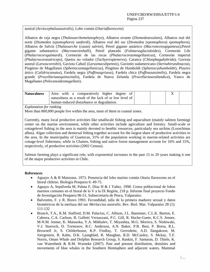
UNEP/CBD/RW/EBSA/ETTP/1/4
Página 237
/…
austral (Arctocephalusaustralis), Lobo común (Otariaflavescens)
Albatros de ceja negra (Thalassarchemelanophrys), Albatros errante (Diomedeaexulans), Albatros real del
norte (Diomedea (epomophora) sanfordi), Albatros real del sur (Diomedea (epomophora) epomophora),
Albatros de Salvín (Thalassarche (cauta) salvini), Petrel gigante antártico (Macronectesgiganteus),Petrel
gigante subantartico (Macronecteshalli), Petrel plateado (Fulmarusglacialoides), Cormorán Lile
(Phalacrocorxgaimardi), Cormorán de las rocas (Phalacrocoraxmagellanicus), Cormorán imperial
(Phalacrocoraxatriceps), Quetru no volador (Tachyerespteneres), Caranca (Chloephagahybrida), Gaviota
austral (Larusscoresbii), Gaviota Cahuil (Larusmaculipennis), Gaviotín sudamericano (Sternahirundinacea),
Pingüino de Magallanes (Spheniscusmagellanicus), Pingüino de Humboldt (Spheniscushumboldti), Playero
ártico (Calidriscanutus), Fardela negra (Puffinusgriseus), Fardela chica (Puffinusassimilis), Fardela negra
grande (Procellariaaequinoctialis), Fardela de Nueva Zelanda (Procellariawestlandica), Yunco de
Magallanes (Pelecanoidesmagellani).
Naturalness Area with a comparatively higher degree of
naturalness as a result of the lack of or low level of
human-induced disturbance or degradation.
X
Explanation for ranking
More than 800,000 people live within the area, most of them in coastal zones.
Currently, many local productive activities like smallscale fishing and aquaculture (mainly salmon farming)
center on the marine environment, while other activities include agriculture and forestry. Small-scale or
cottagelevel fishing in the area is mainly devoted to benthic resources, particularly sea urchins (Loxechinus
albus). Algae collection and demersal fishing together account for the largest share of productive activities in
the area. In the municipality of Guaitecas, 31% of the population working in marine-related activities are
cottage-level fishermen, while in Chaiten, fishing and native forest management account for 16% and 15%,
respectively, of productive activities (2002 Census).
Salmon farming plays a significant role, with exponential increases in the past 15 to 20 years making it one
of the major productive activities in Chile.
References
Aguayo A & R Maturana. 1973. Presencia del lobo marino común Otaria flavescens en el
litoral chileno. Biología Pesquera 6: 49-75.
Aguayo A, Sepúlveda M, Palma F, Díaz H & J Yañez. 1998. Censo poblacional de lobos
marinos comunes en el litoral de la V a la IX Región, 218 p. Informe final proyecto Fondo
de Investigación Pesquera 96-51, Subsecretaría de Pesca, Valparaíso.
Balvontin, F. y R. Bravo 1993. Fecundidad, talla de la primera madurez sexual y datos
biométricos de la merluza del sur Merluccius australis. Rev. Biol. Mar. Valparaíso 28 (1):
111-132
Branch, T.A., K.M. Stafford, D.M. Palacios, C. Allison, J.L. Bannister, C.L.K. Burton, E.
Cabrera, C.A. Carlson, B. Galletti Vernazzani, P.C. Gill, R. Hucke-Gaete, K.C.S. Jenner,
M-N.M. Jenner, K. Matsuoka, Y.A. Mikhalev, T. Miyashita, M.G. Morrice, S. Nishiwaki,
V.J. Sturrock, D. Tormosov, R.C. Anderson, A.N. Baker, P.B. Best, P. Borsa, R.L.
Brownell Jr, S. Childerhouse, K.P. Findlay, T. Gerrodette, A.D. Ilangakoon, M.
Joergensen, B. Kahn, D.K. Ljungblad, B. Maughan, R.D. McCauley, S. Mckay, T.F.
Norris, Oman Whale and Dolphin Research Group, S. Rankin, F. Samaran, D. Thiele, K.
van Waerebeek & R.M. Warneke (2007). Past and present distribution, densities and
movements of blue whales in the Southern Hemisphere and adjacent waters. Mammal
UNEP/CBD/RW/EBSA/ETTP/1/4
Página 238
/…
Review 37(2): 116-175.
Brattström, H. y E. Dahl. 1951. Reports of the Lund University- Chile Expedition 1948-
1949. I General Account, list of stations, hydrography. Lunds Universitets Arsskrift N. F.
Avd. 2 Bd. 46 Nr 8, 86 pp.
Buschmann A. H., J. A. Vásquez, E. P. Osorio, E. Reyes, L. Filun, M. C. Hernández-
González y A. Vega 2004. The effect of water movement, temperature and salinity on
abundance and reproductive patterns of Macrocystis spp. (Phaeophyta) at different
latitudes in Chile. Marine Biology 145, 849-862
Cairns. S., Häussermann, V. y Försterra, G. 2005. A review of the Scleractinia (Cnidaria:
Anthozoa) of Chile, with the description of two new species. Zootaxa 1018: 15–46
Castilla, J. C. 1985. Food webs and functional aspects of the kelp, Macrocystis pyrifera,
community in the Beagle Channel, Chile. In: Siegfried W.R., P.R. Condy & R.M. Laws
(eds.) Antarctic Nutrient Cycles and Food Webs, pp 407-414. Springer-Verlag, Berltn,
Heidelberg.
Chong, J., Aguayo, M. y I. Paya 2007. Estimación de edad, crecimiento y mortalidad
natural de la merluza de cola, Macruronus magellanicus Lönnberg, 1907 (Macruridae,
Gadiformes) en el océano Pacifico suroriental. Revista de Biología Marina y Oceanografía
42(3): 311 – 333
Corcuera, J., F. Monzón, E.A. Crespo, A. Aguilar & J.A Raga. 1994. Interactions between
marine mammals and coastal fisheries of Necochea and Claromecó (Buenos Aires
Province, Argentina). International Whaling Commission, (Special Issue 15): 283-290.
Crespo, E.A. & S.N. Pedraza. 1991. Estado Actual Y Tendencia De La Poblacion De
Lobos Marinos De Un Pelo (Otaria Flavescens) En El Litoral Patagonico. Ecologia Austral
1: 87-95.
Crespo, E.A., J. Corcuera & A. Lopez Cazorla. 1994. Interactions between marine
mammals and fisheries in some fishing areas of the coast of Argentina. International
Whaling Commission, Special Issue 15: 283-290.
Crespo, E.A., S.N. Pedraza, S.L. Dans, M. Koen Alonso, L.M. Reyes, N.A. Garcia, M.
Coscarella & A.C.M. Schiavini. 1997. Direct and indirect effects of the highseas fisheries
on the marine mammal populations in the northern and central patagonian coast. Journal of
the Northwest Atlantic Fishery Science 22:189-207.
Dans, S.L., Koen Alonso, M., Crespo, E.A, Pedraza, S.N. & García, N.A. 2003.
Interactions between Marine Mammals and High Seas Fisheries in Patagonia Under an
Integrated Approach. Pag. 100-115 En: Gales, N., M. Hindell y R.
Dávila, P. M., Figueroa, D. y E. Muller. 2002. Freshwater input into coastal ocean and its
relation with the salinity distribution off austral Chile (35-55°S). Cont. Shelf Resea. 22(3):
521-534.
Försterra G. y Häusermann V. 2003. First report on large scleractinian (Cnidaria:
Anthozoa) accumulations in cold-temperate shallow water of south Chilean fjords.
Zoologische Verhandelingen (Leiden) 345, 117–128.
Försterra, G., Häussermann V. y Carsten, L. 2008. Mass occurrence of the recent
brachiopod Magellania venosa (Terebratellidae) in the fjords Comau and Reñíhué ,
northern Patagonia, Chile. Marine Ecology 29, 1–6.
Freilich, S.Y. 2004. Genetic Diversity and Population Genetic Structure in the South
American Sea Lion (Otaria flavescens) from Argentina and the Falkland Islands. Tesis
doctoral.
George-Nascimiento M, Bustamante R & C Oyarzún. 1985. Feeding ecology of the South
American sea lion Otaria flavescens: food contents and food selectivity. Marine Ecology
Progress Series 21: 135-143.
Goodall, R. N. P. 1994. Chilean dolphins Cephalorhynchus eutropia (Gray, 1846). En:
Handbook of Marine Mammals, pp. 269–287. Ed. por S. H. Ridgway, y S. R. Harrison.

UNEP/CBD/RW/EBSA/ETTP/1/4
Página 239
/…
Academic Press, San Diego.
Grandi M.F., Dans S.L. & Crespo E.A. 2008. Social composition and spatial distribution
of colonies in an expanding population of South American sea lions. Journal of
Mammalogy 89(5)
Häussermann, V. and G. Försterra. 2005. Distribution patterns of Chilean shallow-water
sea anemones (Cnidaria: Anthozoa: Actiniaria, Corallimorpharia), with a discussion of the
taxonomic and zoogeographic relationships between the actinofauna of the South East
Pacific, the South West Atlantic and the Antarctic Reid, J.L. 1965. Intermediate waters of
the Pacific Ocean. The Johns Hopkins Oceanographic Studies, 2: 85 pp. SCI. MAR., 69
(Suppl. 2): 91-102
Heinrich, S. 2006. Ecology of Chilean dolphins and Peale’s dolphins at Isla Chiloe,
southern Chile. PhD thesis, University of St Andrews.
Hucke-Gaete, R. 2004. Distribución, preferencia de hábitat y dinámica espacial de la
ballena azul en Chile: 1997–2004. PhD thesis, Universidad Austral de Chile.
Hucke-Gaete, R., L.P. Osman, C.A. Moreno, K.P. Findlay & D.K. Ljungblad (2004).
Discovery of a blue whale feeding and nursing ground in southern Chile. Proc. R. Soc.
Lond. Ser. B 271: S170–S173.
Hucke-Gaete, R., F. Viddi & M. Bello (2006). Marine conservation in southern Chile: The
importance of the Chiloe-Corcovado region for blue whales, biological diversity and
sustainable development. Published by Centro Ballena Azul (CBA) & Natural Resources
Defense Council (NRDC). Imprenta América. 109 pp (bilingual)
Hucke-Gaete, H. P. Lo Moro y J. Ruiz (Eds.). 2010. Conservando el mar de Chiloé, Palena
y Guaitecas. Síntesis del estudio “Investigación para el desarrollo de Área Marina Costera
Protegida Chiloé, Palena y Guaitecas”. Valdivia, 342 p.
Hückstädt, LA. & T. Antezana. 2003. Behaviour of the southern sea lion (Otaria
flavescens) and consumption of the catch during purse-seining for jack mackerel
(Trachurus symmetricus) off central Chile. ICES Journal of Marine Science, 60: 1–9.
Kirkwood (Eds) Marine Mammals: Fisheries; Tourism and Management Issues CSIRO
Publishing Dans, S.L., E.A. Crespo, S.N. Pedraza & M. Koen Alonso, M. 2004. Recovery
of the south american sea lion population in northern Patagonia. Canadian J. Fisheries and
Aquatic Science. Vol. 61:1681-1690.
Koen Alonso, M., EA. Crespo, SN. Pedraza, NA. García & MA. Coscarella. 2000. Food
habits of the South American sea lion, Otaria flavescens, off Patagonia, Argentina. Fishery
Bulletin 98: 250-263.
Lancelloti, D. y J.A. Vásquez. 1999. Biogeographical patterns of benthic invertebrates in
the southeastern Pacific litoral. Journal of Biogeography 26: 1001-1006.
Mann, K.M. y J.R.N. Lazier. 1991. Dynamics of Marine Ecosystems. Blackwell Scientific
Publications, Massachusetts.
Oporto J, C Mercado & L Brieva. 1991. Conflicting interactions between coastal fisheries
and pinnipeds in Southern Chile, 21p. In: Report on the Benguela Ecology Programme
workshop on seal-fishery biological interactions, University of Cape Town. Working paper
BEP/SW91/R8.
Oporto, J., L. Brieva, R. Navarro & Al Turner. 1999. Informe Final Proyecto FIP 97– 44.
"Cuantificación poblacional de lobos marinos en la X y XI Regiones", 277 p.
Paez, E. 2005. ¿Yo...? Otaria. ¿Y usted... III Jornadas de conservación y uso sustentable de
la fauna marina.
Reyes, L.M., Crespo E.A. & Szapkievich V. 1999. Distribution and population size of the
southern sea lion (Otaria flavescens) in central and southern Chubut, Argentina. Mar.
Mam. Sci. 15(2):478-493.
Reyes-Arriagada, R., P. Campos-Ellwanger, R. Schlatter y C.Baduini. 2007. Sooty
shearwater (Puffinus griseus) on Guafo Island: the largest seabird colony in the World?.
UNEP/CBD/RW/EBSA/ETTP/1/4
Página 240
/…
Biodiversity and Conservation 16,:1913-930.
Riedman, M. 1990. The pinnipeds; Seals, Sea Lions, and Walruses. Berkley: Univ.
California Press.
Ríos, C, W. E. Arntz, D. Gerdes, E. Mutschke & A. Montiel 2007. Spatial and temporal
variability of the benthic assemblages associated to the holdfasts of the kelp Macrocystis
pyrifera in the Straits of Magellan, Chile. Polar Biology 31, 89-100.
Rodríguez, AL. 2005. Evaluación del impacto del lobo marino común Otaria flavescens
(Shaw, 1800) en la actividad diaria de pescadores artesanales en las caletas San Pedro de
Coquimbo y Peñuelas. Tesis para obtener el grado de magíster en Ciencias del Mar.
Universidad Católica del Norte – Sede Coquimbo, Chile. 98 pp.
Rosas, F.C.W., Pinedo M.C., Marmontel M. & Haimovici M. 1994. Seasonal movements
of the South American sea lion (Otaria flavescens, Shaw) off the Rio Grande do Sul coast,
Brazil. Mammalia 58:51-59.
Schiavini, A.C.M., Crespo E.A. & Szapkievich V. 2004. Status of the population of South
American sea lion (Otaria flavescens) in Santa Cruz and Tierra del Fuego Provinces,
Argentina. Mammalian Biology (Zeit. Säuge.) 69:1-11.
Schlatter, R. y A. Simeone. 1999. Estado del conocimiento y Conservación de las aves en
mares chilenos. Estudios Oceanologicos 18, 25-33.
Sielfeld, W. y Castilla J.C. 1999. Estado de conservación y conocimiento de las nutrias en
Chile. Estudios Oceanologicos 18, 69-79
Silva, N. & S. Neshyba. 1977. Corrientes superficiales frente a la costa austral de Chile.
Cienc. Tecnol. Mar, 3: 37-42.
Silva, N. & S. Neshyba. 1979. Masas de agua y circulación geostrófica frente a la costa de
Chile austral. Inst. Antár. Chi., Ser. Cient., 25/26: 5-32.
Silva, N., Calvete M. y H.A. Sievers. 1998. Masas de agua y circulación general para
algunos canales Australes entre Puerto Montt y Laguna San Rafael, Chile (Cimar-Fiordo
1). Ciencia y Tecnología del Mar 21: 17-48.
Silva, N., D. Guzman y H. Sievers. 1999. Distribución de temperatura, salinidad y oxígeno
disuelto, entre la boca del Guafo y el estero Elefantes. Resultados del Crucero CIMAR 4
Fiordos. Comité Oceanográfico Nacional, Valparaíso. Libro de Resúmenes, pp. 13-17.
Viddi, F A. & A.K. Lescrauwaet 2005. Insights on habitat selection and behavioural
patterns of Phale's dolphin (Lagenorhynchus australis) in the Strait of Magellan, southern
Chile. Aquat. Mammals 31(2): 176-183.
Viddi, F.A. 2009. Behavioural ecology of small cetaceans in the Northern Patagonian
fjords, Chile. PhD Thesis, Macquarie University, Sydney, Australia
Viddi, F.A., Hucke-Gaete, R., Torres-Florez, J.P. y Ribeiro, S. 2010. Spatial and seasonal
variability in cetacean distribution in the fjords of northern Patagonian, Chile. ICES
Journal of Marine Science 67, 959–970.
Viddi, F.A., Harcourt, R., Hucke-Gaete, R. y Field, I. C. 2011. Fine-scale movement
patterns of the sympatric Chilean and Peale’s dolphins in the Northern Patagonian fjords,
Chile. Marine Ecology Progress Series 436, 245–256.
Wyrtky, K. 1975. Fluctuation of the dynamic topography inthe Pacific Ocean. J. Phys.
Oceanogr., 5: 450-459.
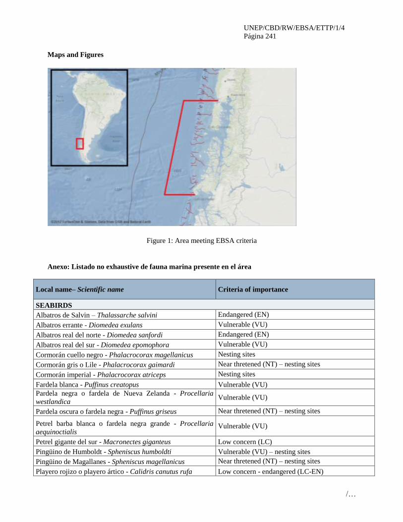
UNEP/CBD/RW/EBSA/ETTP/1/4
Página 241
/…
Maps and Figures
Figure 1: Area meeting EBSA criteria
Anexo: Listado no exhaustive de fauna marina presente en el área
Local name– Scientific name Criteria of importance
SEABIRDS
Albatros de Salvin – Thalassarche salvini Endangered (EN)
Albatros errante - Diomedea exulans Vulnerable (VU)
Albatros real del norte - Diomedea sanfordi Endangered (EN)
Albatros real del sur - Diomedea epomophora Vulnerable (VU)
Cormorán cuello negro - Phalacrocorax magellanicus Nesting sites
Cormorán gris o Lile - Phalacrocorax gaimardi Near thretened (NT) – nesting sites
Cormorán imperial - Phalacrocorax atriceps Nesting sites
Fardela blanca - Puffinus creatopus Vulnerable (VU)
Pardela negra o fardela de Nueva Zelanda - Procellaria
westlandica Vulnerable (VU)
Pardela oscura o fardela negra - Puffinus griseus Near thretened (NT) – nesting sites
Petrel barba blanca o fardela negra grande - Procellaria
aequinoctialis Vulnerable (VU)
Petrel gigante del sur - Macronectes giganteus Low concern (LC)
Pingüino de Humboldt - Spheniscus humboldti Vulnerable (VU) – nesting sites
Pingüino de Magallanes - Spheniscus magellanicus Near thretened (NT) – nesting sites
Playero rojizo o playero ártico - Calidris canutus rufa Low concern - endangered (LC-EN)

UNEP/CBD/RW/EBSA/ETTP/1/4
Página 242
/…
Local name– Scientific name Criteria of importance
INVERTEBRATES
Centolla - Lithodes santolla
Centollón - Paralomis granulosa
Erizo - Loxechinus albus
Huepo - Ensis macha
Ostión del sur - Chlamys vitrea
Ostión patagónico - Chlamys patagonica
Almeja - Venus antiqua
Chorito - Mytilus chilensis
Cholga - Aulacomya ater
Tawera - Tawera gayi
Culenge - Gari solida
Macha - Mesodesma donacium
Navajuela - Tagelus dombeii
Pulpo del sur - Enteroctopus megalocyathus
Tumbao - Semele solida
MARINE MAMMALS
Chungungo - Lontra felina Endangered (EN)
Huillín - Lontra provocax Endangered (EN)
Ballena azul - Balaenoptera musculus Endangered (EN) – Feeding ground
Ballena fin - Balaenoptera physalus Endangered (EN)
Ballena franca austral - Eubalaena australis Critically endangered(CR) – Chile/Peru population
Ballena jorobada - Megaptera novaeangliae Vulnerable (VU) (IUCN- LC)?
Ballena sei - Balaenoptera borealis Endangered (EN)
Cachalote - Physeter macrocephalus Vulnerable (VU)
Delfín austral - Lagenorhynchus australis Data deficient (DD) – Restricted distribution.
Delfín chileno - Cephalorhynchus eutropia Near thretened (NT) - Endemic.
Delfín liso - Lissodelphis peronii Data deficient (DD)
Marsopa espinosa - Phocoena spinnipinnis Data deficient (DD)
Orca - Orcinus orca Data deficient (DD)
Tonina overa - Cephalorhynchus commersonii Data deficient (DD)
Lobo marino de dos pelos sudamericano - Arctocephalus
australis Reproductive colony
Lobo marino de un pelo sudamericano - Otaria flavescens Biggest Chilean reproductive colony
FISHES
Abadejo - Congrio dorado - Genypterus blacodes
Merluza austral - Merluccius australis
Bacalao de profundidad – Dissostichus eleginoides
Merluza de cola – Macruronus magellanicus
Sardina austral – Sprattus fuegensis
Sierra - Thyrsites atun

UNEP/CBD/RW/EBSA/ETTP/1/4
Página 243
/…
Local name– Scientific name Criteria of importance
Raya volantín - Dipturus chilensis
SEAWEED
Chascon o huiro negro - Lessonia nigrescens
Chicorea de mar - Chondracanthus chamissoi
Cochayuyo - Durvillaea antarctica
Huiro - Macrocystis spp
Luga cuchara o corta - Mazzaella laminarioides
Luga negra o crespa - Sarcothalia crispata
Luga-roja - Gigartina skottsbergii
Pelillo - Gracilaria spp
ANEMONE
23 shallow-water sea anemones (Cnidaria: Anthozoa:
Actiniaria, Corallimorpharia) (37% of all described Chilean
sea anemones) (Gunter and Forsterra, 2005)

UNEP/CBD/RW/EBSA/ETTP/1/4
Página 244
/…
ÁREA NO. 21: ÁREA DE ALIMENTACIÓN DEL PETREL GRIS EN LA SUR DEL
DORSAL DEL PACÍFICO ESTE
(GREY PETREL’S FEEDING AREA IN THE SOUTH EAST PACIFIC RISE)
Abstract
This site is the key feeding area for the Antipodes Island, New Zealand population of the Near Threatened
Grey Petrel (Procellaria cinerea) during their non-breeding season. Birds migrate from their breeding
colonies to feed in this area between October and February.
Introduction The site is located near the southern end of the East Pacific Rise, and the western part of the South Pacific
Basin. BirdLife International recognizes this site as an Important Bird Area (IBA) (BirdLife International
2012b).
A habitat use analysis of non-breeding grey petrel tracking data, using boosted regression trees,
determined that bathymetry, mixed layer depth, mean temperature between the surface and 50 m,
chlorophyll a concentration, and current velocity influenced the distribution of the birds (Torres et al,
2012).
Location
The area is completely outside national jurisdiction, located near the southern end of the East Pacific Rise,
and the western part of the South Pacific Basin. The nearest land lies 2000 km south to Antarctica, 2500
km north to Easter Island, 4000 km east to South America, and 7000 km west to New Zealand islands.
The site is approximately bounded as follows: NW -120, -47; NE -112, -49; SE -112, -57, SW -120, -57
Feature description of the proposed area
Eighteen British Antarctic Survey geolocation (GLS) loggers were deployed on Grey Petrel breeding on
Antipodes Island, New Zealand to determine their year round at-sea distribution. All 18 individuals
migrated to this site in the middle of the Pacific Ocean during their non-breeding season between October
2009 and February 2010 (Thompson, 2010).
The population on the Antipodes was estimated at 53,000 pairs in 2001 (Bell, 2002) making it the largest
known colony for this species in the world. BirdLife International conducted an analysis of this tracking
data, which suggests the area used by the tracked population represented those used by up to 80% of the
Antipodes population, ie 80,000 individuals (BirdLife International, 2010a)
Habitat modelling undertaken by the National Institute of Water and Atmosphere (NIWA) in New
Zealand (Torres et al, 2012) shows that the petrels preferred habitats where depths were between 2500
and 3500 m the mean temperature was between 7 and 11 °C between the surface and 50m depth, where
the mixed layer was between 50 and 80 m, the chlorophyll a concentration was between 0.1 and 0.4
mg/m3 and moderate current velocities occurred of between 0.05 and 0.2 m/s.
Feature condition and future outlook of the proposed area It is unknown how these physical oceanographic patterns interact to create enhanced foraging
opportunities for grey petrels. Further research is needed to better understand the reasons for the presence
of the birds here. Limited diet studies indicate that the majority (over 80%) of the Grey Petrel diet is
composed of squid (Ridoux 1994). Little is known of oceanic squid ecology, but they are known to
concentrate around meso-scale fronts and eddies which could be occurring in this area. Further research is
needed to determine these functional mechanisms. However, it is clear that the bathymetric structure is

UNEP/CBD/RW/EBSA/ETTP/1/4
Página 245
/…
influencing the habitat quality in this region and grey petrels prefer using this local ecosystem (Torres et
al, 2012).
Assessment of the area against CBD EBSA Criteria
CBD EBSA
Criteria
(Annex I to
decision
IX/20)
Description
(Annex I to decision IX/20) Ranking of criterion relevance
Don’t
Know
Low Some High
Uniqueness
or rarity
Area contains either (i) unique (“the only one
of its kind”), rare (occurs only in few
locations) or endemic species, populations or
communities, and/or (ii) unique, rare or
distinct, habitats or ecosystems; and/or (iii)
unique or unusual geomorphological or
oceanographic features.
X
Explanation for ranking
It is the only known feeding congregation during the non-breeding season of the Antipodes Islands, new
Zealand population of Grey Petrel.
Special
importance
for life-
history stages
of species
Areas that are required for a population to
survive and thrive. X
Explanation for ranking
This site is the key feeding area for the Near Threatened Grey Petrel (Procellaria cinerea) during their
non-breeding season. Birds migrate from their breeding colonies in the Antipodes Island, New Zealand to
this area in Nov-Feb. The area is thought to be used by up to 80% of the Antipodes population, ie 80,000
individuals (BirdLife International, 2010a)
Importance
for
threatened,
endangered
or declining
species
and/or
habitats
Area containing habitat for the survival and
recovery of endangered, threatened, declining
species or area with significant assemblages of
such species.
X
Explanation for ranking
The Grey Petrel is listed as Near Threatened on the IUCN Red List (BirdLife International, 2012).
Vulnerability,
fragility,
sensitivity, or
slow recovery
Areas that contain a relatively high proportion
of sensitive habitats, biotopes or species that
are functionally fragile (highly susceptible to
degradation or depletion by human activity or
by natural events) or with slow recovery.
X
Explanation for ranking
All seabirds are long lived (several decades) and slow at reproducing (normally 1 chick a year, and often
taking several years to reach maturity) making them vulnerable and slow to recover following decline
(ACAP, 2009).

UNEP/CBD/RW/EBSA/ETTP/1/4
Página 246
/…
The Grey Petrel was the fourth most common seabird species observed as incidental bycatch in New
Zealand fisheries between 1998-2004, but the second most common observed on bottom longline vessels
(Waugh et al 2008)
Biological
productivity
Area containing species, populations or
communities with comparatively higher
natural biological productivity.
X
Explanation for ranking
Habitat modeling has suggested that the area may be productive, and provide an abundant food source for
the grey petrel, however the linkages are not yet fully understood (Torres et al 2012) hence the criteria is
scored as don’t know at this stage.
Biological
diversity
Area contains comparatively higher diversity
of ecosystems, habitats, communities, or
species, or has higher genetic diversity.
X
Explanation for ranking
No other seabird species are currently known to use this area to any significant degree, though satellite
tracking data shows that several species (eg Grey-headed Albatross Thalassarche chrysostoma and
Wandering Albatross Diomedea exulansfrom South Georgia) pass through the area on migration as they
travel from breeding sites in New Zealand to feeding areas off the coast of south America during their
non-breeding seasons (www.seabirdtracking.org).
Naturalness Area with a comparatively higher degree of
naturalness as a result of the lack of or low
level of human-induced disturbance or
degradation.
X
Explanation for ranking
Given the isolated location of the site, several thousand kilometers from the nearest land, it seems likely
that the site exhibits a high degree of naturalness, however it has not been surveyed to any degree, so has
been scored as don’t know at this stage.
Sharing experiences and information applying other criteria
Other Criteria Description Ranking of criterion relevance
Don’t
Know
Low Some High
Add relevant criteria
BirdLife International Important Bird Area
(IBA) criteria
X
Explanation for ranking
BirdLife IBA criteria A4ii is triggered here, an area holding >1% of the global population of a seabird
species, on the basis of the Grey Petrel congregation. IBA criteria A4iii is also triggered, an area holding
>20,000 pairs of seabirds.
References
BirdLife International (2010a). Marine Important Bird Areas toolkit: standardised techniques for
identifying priority sites for the conservation of seabirds at sea. BirdLife International, Cambridge
UK. Version 1.2: February 2011

UNEP/CBD/RW/EBSA/ETTP/1/4
Página 247
/…
Bell, E. 2002. Grey Petrels (Procellaria cinerea) on Antipodes Island, New Zealand: research
feasibility, April-June 2001.
Torres L.G., Thompson D.R., Phillips R.A., Sagar P.M., Sutton P. and Sommer E. (2012). Grey
Petrel non-breeding habitat use patterns: what’s in the middle of no place? Paper presented to the
5th International Albatross and Petrel Conference, Wellington, New Zealand. August 2012.
BirdLife International (2012a) IUCN Red List for birds. Downloaded from
www.birdlife.org/datazone/species/search
ACAP. 2009. ACAP Species Assessment: Grey Petrel Procellaria cinerea. Available at:
#http://www.acap.aq/acap-species/download-document/1181-grey-petrel.
Thompson D. (2010). Data housed in the Global Procellariifrom Tracking database. See
http://www.seabirdtracking.org/dataset.php?id=634
BirdLife International (2012b) Important Bird Areas factsheet. Downloaded from
www.birdlife.org/datazone/site/search on 29/08/2012
Ridoux, V. 1994. The diets and dietary segregation of seabirds at the subantarctic Crozet Islands.
Marine Ornithology 22: 1-192.
Waugh, S.M., MacKenzie, D.I., and Fletcher, D. 2008. Seabird bycatch in New Zealand trawl and
longline fisheries 1998-2004. Papers and Proceedings of the Royal Society of Tasmania 142: 45-
66.

UNEP/CBD/RW/EBSA/ETTP/1/4
Página 248
/…
Maps and Figures
Image courtesy of BirdLife International (2012a) showing location of site
Image courtesy of Torres et al (2012) showing (a) current velocities (scaled by length of white arrows)
overlaid on bathymetry, and tracking locations (black dots) overlaid on climatologies of (b) mixed layer
depth and (c) current velocity.

UNEP/CBD/RW/EBSA/ETTP/1/4
Página 249
/…
Rights and permissions
The “current velocity magnitude over bathymetry” image can only be used with the written approval from
the data owners at NIWA (L. Torres and D. Thompson).
Seabird tracking data used in this analysis is property of the data owners, images provided here can be
used with appropriate credits (not including the “current velocity magnitude over bathymetry” image).
Any request to publish these images elsewhere or to use the original tracking data will require permission;
requests should be made to BirdLife International ([email protected])
-----