防災科学 v o l canic 技術研究所 disasters 要覧supercomputer building...
TRANSCRIPT

● 筑波大学 University of Tsukuba
● 防災科学技術研究所 NIED
つくば駅Tsukuba Sta.
土浦駅Tsuchiura Sta.
荒川沖駅Arakawaoki Sta.
ひたち野うしく駅Hitachinoushiku Sta.
至上野to Ueno
至水戸to Mito
研究学園駅Kenkyū-gakuen Sta.
万博記念公園駅Bampaku-kinenkōen Sta.
みどりの駅Midorino Sta.
みらい平駅 Miraidaira Sta.
谷田部I.C. Yatabe I.C.
つくば牛久I.C. Tsukuba-Ushiku I.C.
牛久阿見I.C.Ushiku-Ami I.C.
つくば中央I.C. Tsukuba-chuo I.C.
桜土浦 I.C.Sakuratsuchiura I.C.
土浦北 I.C.Tsuchiurakita I.C.
つくばJCT Tsukuba JCT
408
408
354
6
125
常磐自動車道
JOBAN EXPRESSWAY
圏央
道
KEN-O EXPRESSWAY
Tsukuba Express
つくばエクスプレス
Science-Odori
サイエンス大通り
Nishi-Odori
西大通り
Higashi-Odori
東大通り
● つくばセンター Tsukuba Center
Ushiku - Gakuen sen
牛久学園線
JR Joban Line
JR常磐線 国立研究開発法人
防災科学技術研究所要覧
Introductionto NIED
国立研究開発法人防災科学技術研究所National Research Institute for Earth Science and Disaster Prevention (NIED)URL : http : //www.bosai.go.jp
本所〒305-0006 茨城県つくば市天王台 3-1Tel.029-851-1611 Fax.029-851-3246 E-mail : [email protected], Tennodai, Tsukuba-shi, Ibaraki-ken, 305-0006 Japan Phone +81-29-851-1611 Fax +81-29-851-3246
雪氷防災研究センター〒940-0821 新潟県長岡市栖吉町前山 187-16 Tel.0258-35-7520 Fax.0258-35-0020Snow and Ice Research Center 187-16, Maeyama, Suyoshi-machi Nagaoka-shi, Niigata-ken, 940-0821, Japan Phone +81-258-35-7520 Fax +81-258-35-0020
雪氷防災研究センター新庄雪氷環境実験所〒996-0091 山形県新庄市十日町高壇 1400 Tel.0233-22-7550 Fax.0233-22-7554Shinjo Cryospheric Environment Laboratory, Snow and Ice Research Center 1400, Takadan, Toka-machi, Shinjo-shi, Yamagata-ken, 996-0091, Japan Phone +81-233-22-7550 Fax +81-233-22-7554
兵庫耐震工学研究センター〒673-0515 兵庫県三木市志染町三津田西亀屋 1501-21Tel.0794-85-8211 Fax.0794-85-7994Hyogo Earthquake Engineering Research Center 1501-21, Nishikameya, Mitsuda, Shijimi-cho, Miki-shi, Hyogo-ken, 673-0515, Japan Phone +81-794-85-8211 Fax +81-794-85-7994
敷地面積274,011m2
防災科学技術研究所前(花畑、防災科技研)
P研究交流棟
守衛所・正門
研究本館Main Research
Building
第1地震調査研究棟
第2地震調査研究棟
防災研究データセンター棟
学園東大通り
大型耐震実験施設
↓つくばセンター
大型降雨実験施設
0 100 m 200 m 300 m
N
Large-scale Rainfall Simulator
Large-ScaleEarthquake Simulator
SecondEarthquake Research Building
First EarthquakeResearch Building
Main Entrance
Research Communication
Building
アウトリーチ棟Outreach Building
National DisastersInformation Center
Bus stop(Bosai Kagakugijutsu Kenkyu-sho)
防災科学技術研究所前(花畑、防災科技研)
Bus stop(Bosai Kagakugijutsu Kenkyu-sho)
Gakuen Higashi-O
dori
to Tsukuba Center
↑筑波山to Mt. Tsukuba
● 施設の配置
● 近隣の略図
秋葉原駅Akihabara Sta.
つくば駅Tsukuba Sta.
東京駅 Tokyo Sta.
上野駅 Ueno Sta.
Hitachinoushiku Sta.
ひたち野うしく駅
Arakawaoki Sta.
荒川沖駅
Tsuchiura Sta.
土浦駅
テクノパーク大穂行防災科技研 下車筑波山口行花畑 下車
タクシー約12分Taxi (about 12min.)
一般道約25分about 25min.
一般道約20分about 20min.
東京 三郷 I.C.
谷田部 I.C.
桜土浦 I.C.
Tsukuba Center
つくばセンター
バス約25分
つくばエクスプレス約45分(快速)
J R常磐線約60分~70分
高速バス約65分
首都高 常磐自動車道
バス約25分バス約25分
バス約20分つくバス約15分
Bus (about 15~20min.)
防災科学技術研究所
Tokyo Misato I.C. Yatabe I.C. Sakuratsuchiura I.C.
Bus (about 25min.)
Shuto Expressway Joban Expressway
JR Joban Line (about 60~70min.)
Tsukuba Express (about 45min.)
Joban Highway Bus (about 65min.)
to Techno park Oho
● 交通機関の案内
企画製作:アウトリーチ・国際研究推進センター アウトリーチグループ監 修:アウトリーチ・国際研究推進検討委員会印 刷:株式会社イセブグリーン調達法適合用紙使用(2015.6.30 5000)
● つくばエクスプレスをご利用の方TX つくば駅より、つくバス北部シャトル「筑波山口」行か関東鉄道バス「テクノパーク大穂」行をご利用ください。つくバス「花畑」、関東鉄道バス「防災科技研」下車徒歩 5 分。
● 高速バス / 路線バスをご利用の方東京駅より高速バス、常磐線ひたち野うしく駅、荒川沖駅、土浦駅から路線バスにて「つくばセンター(TX つくば駅)」行をご利用ください。つくば駅からは、上記に記載のつくバスもしくは関東鉄道バスをご利用ください。
● 車をご利用の方谷田部 IC もしくは 桜土浦 IC を出て、東大通りを筑波山に向かって北上してください。防災科研は東大通り沿いにあります。
● By Tsukuba Express (TX)From Tsukuba Station, take either the “Tsuku Bus” northern route shuttle bound for “Tsukubasan-guchi” or the Kanto Tetsudo bus bound for “Techno Park Sakura.” It is an approximately five-minute walk from both the “Hanabatake” bus stop of the “Tsuku Bus” and the “Bosai-kagiken” bus stop of the Kanto Tetsudo bus.
● By highway bus / route bus Take an express bus from JR Tokyo Station or a route bus from Joban Line Hitachinoushiku Station, Arakawaoki Station, or Tsuchiura Station bound for Tsukuba Center (TX Tsukuba Station). From Tsukuba Station, take either the “Tsuku Bus” or the Kanto Tetsudo bus mentioned above.
● By carGet off at the Yatabe Interchange or the Sakura Tsuchiura Interchange and take Higashi-Odori northbound toward Mt. Tsukuba. NIED is located on Higashi-Odori.
Earthquake
Disasters
Volcanic
Disasters
Meteorological
andLandslide
Disasters
Snow and Ice
DisastersResilient
Society
to Disasters
National Research Institute for Earth Science and Disaster Prevention
スーパーコンピュータ棟SupercomputerBuilding

国立研究開発法人 防災科学技術研究所
理事長 岡田 義光
Dr. Yoshimitsu OkadaPresident
National Research Institute forEarth Science and Disaster Prevention
我が国は、その地学的環境から地震・津波・火山噴火・地滑り・風水害・雪害など、自然災害の多
い国です。とくに平成 23 年 3 月に発生した東日本大震災では、2 万人近い死者・行方不明者を生じ
る未曽有の大災害となりました。自然災害による被害を軽減することは我が国にとって最重要な政策
課題のひとつであり、防災科学技術研究所は「災害に強い社会の実現」を基本目標として、日夜、研
究活動に努めております。
地震分野では、平成7年の阪神・淡路大震災を受けて全国的な地震観測網、および実大三次元震動
破壊実験施設を整備し、緊急地震速報の実用化や構造物の破壊過程解明などを進めてきました。東日
本大震災後は日本海溝海底地震津波観測網を整備し、津波早期予測技術の開発を行っています。火山
分野では、我が国の主要な活動的火山に基盤的観測施設を整備してデータの収集・流通を行うととも
に、平成 26 年 9 月の御嶽山噴火を受け、新たな噴火予測技術の開発に努めています。
次に気象分野では、当研究所が培ってきた気象レーダ技術が、近年大きな問題となっている集中豪
雨や竜巻等の監視に威力を発揮することが実証され、XRAIN として社会実装される一方、浸水被害や
土砂災害などの危険度をより的確に予測する技術の開発に役立てられています。雪氷分野では、降積
雪の予測から始まり、雪崩や地吹雪などの発生危険度を推定する「雪氷災害発生予測システム」がほ
ぼ実用化の域に達し、地方自治体や道路管理事業者等と協力した試験運用が開始されています。
さらに、全国各地の地震危険度や揺れ易さを示す「地震動予測地図」をはじめ、各種の自然災害に
対するハザード情報の整備を進めると同時に、それを個人や地域にとってのリスク情報に変換し、国
民一人ひとりに届けることができる環境の構築を目的として、社会科学的なプロジェクトも鋭意進め
られています。平成 26 年 10 月には、内閣府が府省連携施策として推進する「戦略的イノベーション
創造プログラム(SIP)」に含まれる防災課題について当研究所が中心的な役割を担うこととなったため、
新たな所内組織として「レジリエント防災・減災研究推進センター」を発足させました。
防災科学技術研究所は、平成 27 年 4 月より国立研究開発法人として新たな歩みを始めましたが、
今後とも「災害に強い社会の実現」をめざし、基礎研究から社会実装に至る一貫した研究開発を進め
てまいります。関係の皆さま方には、どうぞ暖かいご支援とご指導をお願い致します。
Due to its geographical and geological environment, Japan has long suffered from natural disasters such as earthquakes, tsunamis, volcanic eruptions, landslides, floods, heavy snow, and so on. In particular, the 2011 Great East Japan Earthquake caused unprecedented disaster with nearly 20 thousand casualties and missing people. Since mitigation of natural disaster is one of the most important political issues in Japan, everyone at NIED is pushing hard research activities under the basic objective of our institute, “Realization of a society resilient to natural disasters.”
As to seismic hazard, we have constructed a nationwide seismic network (Hi-net, F-net, K-NET) and 3D Full-Scale Earthquake Testing Facility (E-Defense) after the disastrous Kobe Earthquake in 1995. The dense seismic network is contributing to the “Earthquake Early Warning” system, which started its full-scale operation in October of 2007, while E-Defense is contributing to accumulate experimental data for various kinds of structure validation and improvement of earthquake-proof designs. After the 2011 Great East Japan Earthquake, we started the construction of “Seafloor Observation Network for Earthquakes and Tsunamis along the Japan Trench” to develop a precise “Tsunami Early Warning” system. As to volcanic hazard, we are engaged in the construction of a basic observation system for major active volcanoes in Japan in order to establish a data collection system for monitoring at the Japan Meteorological Agency as well as providing data for volcanic researches performed by universities. Triggered by abrupt eruption of Mt. Ontake in September of 2014, we also started to develop new technology for early detection of volcanic eruption utilizing a ground radar system.
As to meteorological hazard, we have developed advanced radar technology to observe extreme weather such as severe rainfall and tornado, which is transferred to the XRAIN system and is applied to the warning systems for urban floods and landslides. As to snow and ice hazard, steady efforts have been continuing to develop a warning system for snow avalanches and drifting snow, whose pilot operation is conducted in cooperation with local governments and road management offices. We are also compiling hazard information to make hazard maps for each disaster category and promoting a social science project to construct an environment for providing risk information to individuals and local communities. In October 2014, “Research Center for Reinforcement of Resilient Function” was formed as our new department, because our institute was set to play a leading role in responding to the disaster prevention related problems addressed by the SIP (Cross-ministerial Strategic Innovation Promotion Programs) initiated by the CSTI (Council for Science, Technology and Innovation) of the Cabinet Office.
In April 2015, NIED made a fresh start as a National Research and Development Agency. In order to build a society resilient to natural disasters, we will make continuous efforts in research activities from basic studies to social implementation. We would very much appreciate if you would continue to support us.
Introduction to NIED
ごあいさつ�������������������������������������������������� Greetings

組織図・職員数・予算
研究所沿革
研究拠点と観測網等
基盤的な高精度地震火山観測研究
地殻活動の観測予測技術開発
地震津波の即時予測技術高度化研究
火山活動の観測予測技術開発
地震・火山観測網
都市圏における複合水災害の発生予測に関する研究
高度降積雪情報に基づく雪氷災害軽減研究
実大三次元震動破壊実験施設(E-ディフェンス)を活用した社会基盤研究
災害リスク情報に基づく社会防災システム研究
国際的な研究活動の推進
アウトリーチ活動の推進
災害資料の収集と提供
これまでの主な外部資金プロジェクト
共用施設
主な研究成果
災害への対応
2
3
4
6
7
8
9
11
13
19
27
15
23
28
32
17
25
30
Organization, staff, and budget
History of NIED
Location of research centers and observation stations
Research on earthquakes and volcanoes based on a fundamental precise monitoring network
Development of monitoring and forecasting technology for crustal activity
Research on tsunamis and earthquakes for creation of a disaster mitigation system
Development of monitoring and forecasting technology for volcanic activity
Seismic and volcanic observation networks (Hi-net, F-net, K-NET, KiK-net, V-net and S-net)
Research on prediction of complex water-related disasters in urban areas
Research on advanced snow information and its application to disaster mitigation
Earthquake engineering research utilizing the 3-D Full-Scale Earthquake Testing Facility (E-Defense)
Research on a social disaster prevention system
Promotion of international research activities
Outreach activities
DIL : Archives on natural disaster information
Notable research projects supported by external funds
Common-use facilities
Major research results of NIED
Measures taken against disasters36
目次�������������������������������������������������� Contents
理事長
理事
経営企画室
総務部
観測・予測研究領域
減災実験研究領域
社会防災システム研究領域
監査・コンプライアンス室
地震・火山防災研究ユニット 地震・火山観測データセンター
水・土砂防災研究ユニット
雪氷防災研究センター
兵庫耐震工学研究センター
災害リスク研究ユニット
アウトリーチ・国際研究推進センター
IT統括室
アウトリーチグループ
国際研究推進グループ
自然災害情報室
総務グループ
研究支援グループ
監事
監事 海底地震津波観測網整備推進室Japan Trench Seismic and Tsunami Observation Network Project Office
President, Chief Executive Officer
Executive Director, Executive Officer
General Auditor
General Auditor
General Affairs Department
Department of Monitoring and Forecasting Research
Department of Disaster Mitigation Research
Department of Integrated Research on Disaster Prevention
General Affairs Group
Research Services Group
Earthquake and Volcano Research Unit
Storm, Flood and Landslide Research Unit
Snow and Ice Research Center
Hyogo Earthquake Engineering Research Center
Disaster Risk Research Unit
Outreach and International Research Promotion Center
Auditing and Compliance Office
Earthquake and Volcano Data Center
Computer and Network Management Office
Outreach Group
International Research Promotion Group
Disaster Information Laboratory
Strategic Planning Department
レジリエント防災・減災研究推進センターResearch Center for Reinforcement of Resilient Function
研究推進室Research Promotion Office
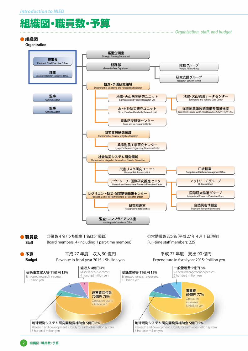
雑収入 4億円 4%Miscellaneous income:4 hundred million yen
一般管理費 5億円 6%General management expenses:5 hundred million yen
地球観測システム研究開発費補助金 5億円 5%Research and development subsidy for earth observation system:5 hundred million yen
受託業務等 11億円 12%Entrusted research expenses:1.1 billion yen
受託事業収入等 11億円 12%Entrusted research income:1.1 billion yen
地球観測システム研究開発費補助金 5億円 6%Research and development subsidy for earth observation system:5 hundred million yen
運営費交付金70億円 78%Operation grant:7 billion yen
Operation expenses:6.9 billion yen
事業費69億円 77%
◎役員4名(うち監事1名は非常勤) ◎常勤職員 225 名(平成 27 年4月1日現在)Board members: 4 (including 1 part-time member) Full-time staff members: 225
平成 27 年度 収入 90 億円Revenue in fiscal year 2015:9billion yen
平成 27 年度 支出 90 億円Expenditure in fiscal year 2015: 9billion yen
● 組織図Organization
● 職員数Staff
● 予算Budget
Introduction to NIED
2 組織図・職員数・予算
組織図・職員数・予算���������������������������������������� Organization, staff, and budget
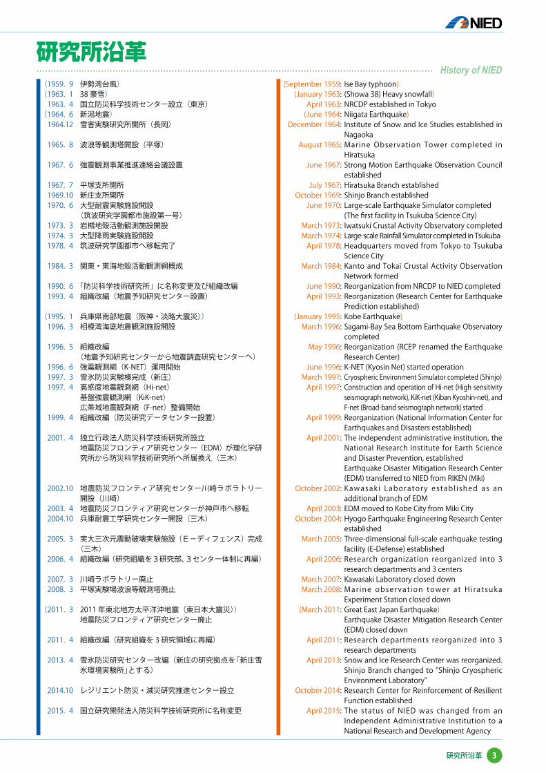
(1959. 9 伊勢湾台風)(1963. 1 38 豪雪)
1963. 4 国立防災科学技術センター設立(東京)(1964. 6 新潟地震)
1964.12 雪害実験研究所開所(長岡)
1965. 8 波浪等観測塔開設(平塚)
1967. 6 強震観測事業推進連絡会議設置
1967. 7 平塚支所開所 1969.10 新庄支所開所 1970. 6 大型耐震実験施設開設 (筑波研究学園都市施設第一号) 1973. 3 岩槻地殻活動観測施設開設 1974. 3 大型降雨実験施設開設 1978. 4 筑波研究学園都市へ移転完了
1984. 3 関東・東海地殻活動観測網概成
1990. 6 「防災科学技術研究所」に名称変更及び組織改編 1993. 4 組織改編(地震予知研究センター設置)
(1995. 1 兵庫県南部地震(阪神・淡路大震災)) 1996. 3 相模湾海底地震観測施設開設
1996. 5 組織改編 (地震予知研究センターから地震調査研究センターへ) 1996. 6 強震観測網(K-NET)運用開始 1997. 3 雪氷防災実験棟完成(新庄) 1997. 4 高感度地震観測網(Hi-net) 基盤強震観測網(KiK-net) 広帯域地震観測網(F-net)整備開始 1999. 4 組織改編(防災研究データセンター設置)
2001. 4 独立行政法人防災科学技術研究所設立 地震防災フロンティア研究センター(EDM)が理化学研
究所から防災科学技術研究所へ所属換え(三木)
2002.10 地震防災フロンティア研究センター川崎ラボラトリー開設(川崎)
2003. 4 地震防災フロンティア研究センターが神戸市へ移転 2004.10 兵庫耐震工学研究センター開設(三木)
2005. 3 実大三次元震動破壊実験施設(E-ディフェンス)完成(三木)
2006. 4 組織改編(研究組織を3研究部、3センター体制に再編)
2007. 3 川崎ラボラトリー廃止 2008. 3 平塚実験場波浪等観測塔廃止
(2011. 3 2011 年東北地方太平洋沖地震(東日本大震災)) 地震防災フロンティア研究センター廃止 2011. 4 組織改編(研究組織を 3 研究領域に再編)
2013. 4 雪氷防災研究センター改編(新庄の研究拠点を「新庄雪氷環境実験所」とする)
2014.10 レジリエント防災・減災研究推進センター設立
2015. 4 国立研究開発法人防災科学技術研究所に名称変更
(September 1959:(January 1963:
April 1963:(June 1964:
December 1964:
August 1965:
June 1967:
July 1967:October 1969:
June 1970:
March 1973:March 1974:
April 1978:
March 1984:
June 1990:April 1993:
(January 1995:March 1996:
May 1996:
June 1996:March 1997:
April 1997:
April 1999:
April 2001:
October 2002:
April 2003:October 2004:
March 2005:
April 2006:
March 2007:March 2008:
(March 2011:
April 2011:
April 2013:
October 2014:
April 2015:
Ise Bay typhoon)(Showa 38) Heavy snowfall)NRCDP established in TokyoNiigata Earthquake)Institute of Snow and Ice Studies established in NagaokaMarine Observation Tower completed in HiratsukaStrong Motion Earthquake Observation Council establishedHiratsuka Branch establishedShinjo Branch establishedLarge-scale Earthquake Simulator completed(The first facility in Tsukuba Science City)Iwatsuki Crustal Activity Observatory completed Large-scale Rainfall Simulator completed in TsukubaHeadquarters moved from Tokyo to Tsukuba Science CityKanto and Tokai Crustal Activity Observation Network formedReorganization from NRCDP to NIED completedReorganization (Research Center for Earthquake Prediction established)Kobe Earthquake)Sagami-Bay Sea Bottom Earthquake Observatory completedReorganization (RCEP renamed the Earthquake Research Center)K-NET (Kyosin Net) started operationCryospheric Environment Simulator completed (Shinjo)Construction and operation of Hi-net (High sensitivity seismograph network), KiK-net (Kiban Kyoshin-net), and F-net (Broad-band seismograph network) started Reorganization (National Information Center for Earthquakes and Disasters established)The independent administrative institution, the National Research Institute for Earth Science and Disaster Prevention, establishedEarthquake Disaster Mitigation Research Center (EDM) transferred to NIED from RIKEN (Miki)Kawasak i Laboratory establ i shed as an additional branch of EDMEDM moved to Kobe City from Miki CityHyogo Earthquake Engineering Research Center establishedThree-dimensional full-scale earthquake testing facility (E-Defense) establishedResearch organization reorganized into 3 research departments and 3 centersKawasaki Laboratory closed downMar ine observat ion tower at H i ratsuka Experiment Station closed downGreat East Japan Earthquake)Earthquake Disaster Mitigation Research Center (EDM) closed downResearch departments reorganized into 3 research departmentsSnow and Ice Research Center was reorganized. Shinjo Branch changed to "Shinjo Cryospheric Environment Laboratory"Research Center for Reinforcement of Resilient Function establishedThe status of NIED was changed from an Independent Administrative Institution to a National Research and Development Agency
3研究所沿革
研究所沿革����������������������������������������������� History of NIED

本所 Headquarters
研究拠点 Research centers
地震観測網 Seismograph networks
F-net Hi-net / KiK-net K-NET
火山観測網 Volcanic observation network
V-net
気象等観測施設 Meteorological observation facilities and others
MPレーダ MP radars
山地積雪気象観測点 Snow and weather observation network
南西諸島Nansei Shoto
雪氷防災研究センター 新庄雪 氷環境実験所(山形県新庄市)Shinjo Cryospheric Environment Labor atory, Snow and Ice Research Center(Shinjo City, Yamagata Prefecture)
雪氷防災研究センター(新潟県長岡市)Snow and Ice Research Center (Nagaoka City, Niigata Prefecture)
兵庫耐震工学研究センター(兵庫県三木市)Hyogo Earthquake Engineering Research Center(Miki City, Hyogo Prefecture)
Introduction to NIED
4 研究拠点と観測網等
研究拠点と観測網等����������������������������� Location of research centers and observation stations
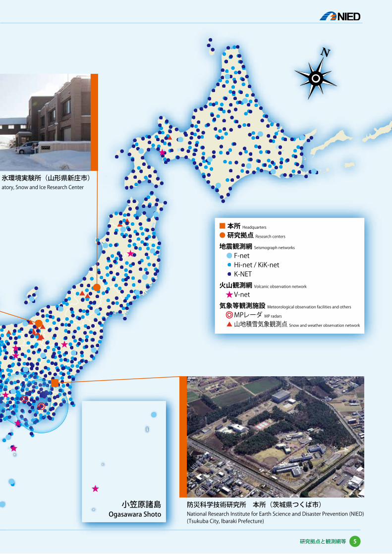
本所 Headquarters
研究拠点 Research centers
地震観測網 Seismograph networks
F-net Hi-net / KiK-net K-NET
火山観測網 Volcanic observation network
V-net
気象等観測施設 Meteorological observation facilities and others
MPレーダ MP radars
山地積雪気象観測点 Snow and weather observation network
小笠原諸島Ogasawara Shoto
雪氷防災研究センター 新庄雪 氷環境実験所(山形県新庄市)Shinjo Cryospheric Environment Labor atory, Snow and Ice Research Center(Shinjo City, Yamagata Prefecture)
防災科学技術研究所 本所(茨城県つくば市)National Research Institute for Earth Science and Disaster Prevention (NIED)(Tsukuba City, Ibaraki Prefecture)
5研究拠点と観測網等

地震観測網の安定的な運用並びに新たな火山観測網の構築を行う。そこから得られるデータを基に地殻活動モニタリングシステムの高度化を行う。
We maintain nationwide precise seismic observation networks and are developing a new volcanic observation network. Based on observed data, we have developed advanced methods for monitoring crustal activity in and around Japan.
● 地殻活動モニタリングシステムの高度化Improvement of the crustal activity monitoring system
これまで沈み込むプレート境界付近において深部低周波微動、スロースリップイベント、浅部超低周波地震などが発見されてきました。これらの活動を実時間で補足するなど、地殻活動モニタリングシステムを高度化することによって地殻の状態を迅速かつ的確に把握します。
We have discovered new geophysical phenomena, such as deep low-frequency tremors, slow slip events, and very-low-frequency earthquakes along the subduction plate boundary. The monitoring systems have been improved to detect these activities immediately and to clarify the physical state of the crust.
2011年東北地方太平洋沖地震の震源付近では、本震発生の数年前から地球潮汐と地震の発生タイミングの
間に強い相関関係が見られるようになり、本震発生後には相関関係は見られなくなりました。ひずみが十分にたまった巨大地震の発生直前には、地球潮汐のわずかな力が地震発生の「最後の一押し」として働くと考えられます。このような現象は 2004 年スマトラ島沖地震でも確認されています。
In the several years before the 2011 Tohoku earthquake, a strong correlation between earth tides and earthquakes was found in the region where the main shock rupture initiated. This correlation vanished after the Tohoku earthquake, suggesting tidal forces do trigger an earthquake on a fault that is critically stressed. Similar observation has been made for the 2004 Sumatra earthquake.
○ 浅部超低周波地震Shallow very-low-frequency earthquake
○ スローイベントの連動Synchronization of different types of slow event
隣接観測点では地震波形が似る性質を利用して、波が伝わる様子を常時監視する手法を開発しました。この手法によってゆっくり地震(超低周波地震)の検出率が向上し、従来より知られていた西南日本の浅部だけではなく、2003 年十勝沖地震の発生した領域でも発生していることが明らかになりました。
We have developed methods to detect very-low-frequency earthquakes (VLFEs) based on waveform correlation and grid moment tensor analysis. The results of these analyses show that the VLFEs occur not only in southwestern Japan but also in Tokachi-oki, northeastern Japan, in a region where an M8 earthquake occurred in 2003.
豊後水道において数年おきにスロースリップが発生(図 A 灰色部分、図 B 薄桃色矩形領域)していますが、その際にトラフよりの微動活動(図 A 赤線、図 B 赤点)、浅部超低周波地震(図 A 桃色線、図 B 桃色円)が同期して活発化することが発見されました。ことに浅部超低周波地震が同期することからスロースリップ域が従来考えられていた領域よりトラフ側に広がっている可能性が示唆されました。
Slow slip events have occurred every several years at the Bungo Channel (the gray bars in panel A and the pink rectangular area in panel B). At the same time, the activities of up-dip tremors (the red line in A and the red dots in B) and shallow very-low-frequency earthquakes (the pink line in A and the pink circles in B) were also detected. This suggests that the slow slip area may extend to the trough area.
● 東北地方太平洋沖地震に先行する地球潮汐の地震トリガー作用Tidal triggering of earthquakes preceding the 2011 Tohoku earthquake
プレート境界で発生している各種スローイベントVarious slow events found at the descending Philippine Sea Plate
A
B
6
Introduction to NIED
観測・予測研究領域
Department of M
onitoring and Forecasting Research
減災実験研究領域
Department of Disaster M
itigation Research
社会防災システム研究領域
Department of Integrated Research on Disaster Prevention
基盤的な高精度地震火山観測研究
基盤的な高精度地震火山観測研究���������� Research on earthquakes and volcanoes based on a fundamental precise monitoring network
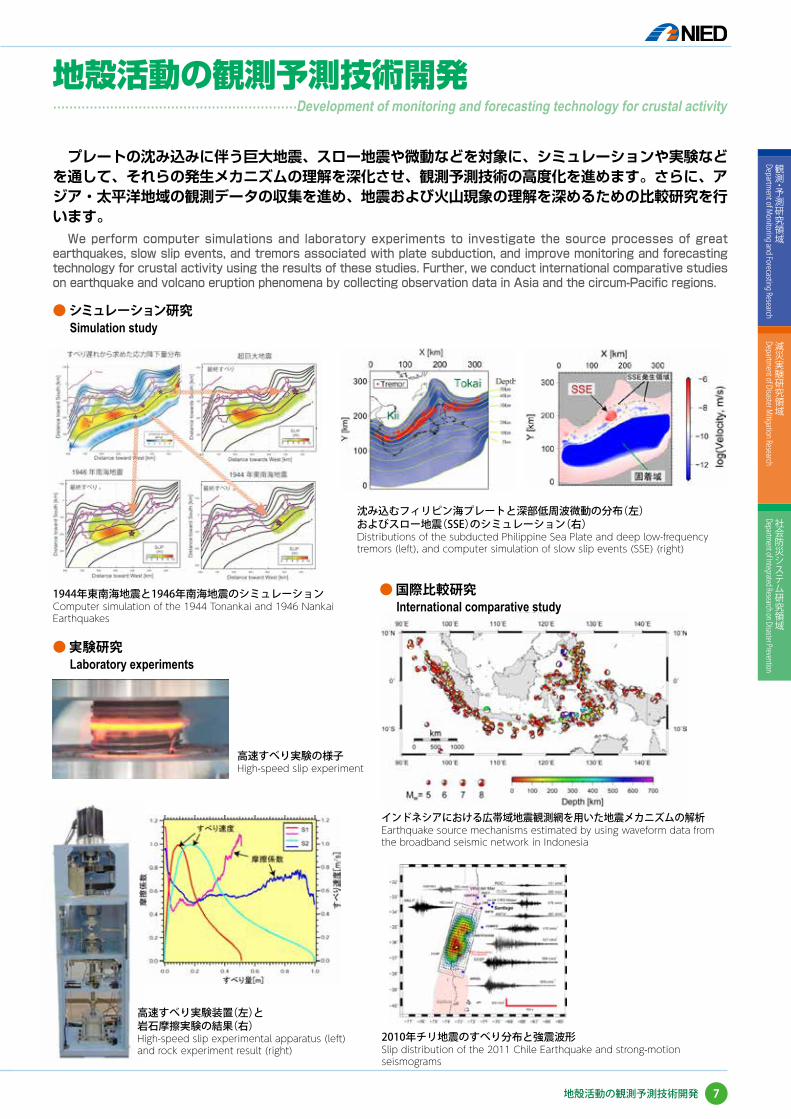
プレートの沈み込みに伴う巨大地震、スロー地震や微動などを対象に、シミュレーションや実験などを通して、それらの発生メカニズムの理解を深化させ、観測予測技術の高度化を進めます。さらに、アジア・太平洋地域の観測データの収集を進め、地震および火山現象の理解を深めるための比較研究を行います。
We perform computer simulations and laboratory experiments to investigate the source processes of great earthquakes, slow slip events, and tremors associated with plate subduction, and improve monitoring and forecasting technology for crustal activity using the results of these studies. Further, we conduct international comparative studies on earthquake and volcano eruption phenomena by collecting observation data in Asia and the circum-Pacific regions.
● シミュレーション研究Simulation study
● 実験研究Laboratory experiments
● 国際比較研究International comparative study
1944年東南海地震と1946年南海地震のシミュレーションComputer simulation of the 1944 Tonankai and 1946 Nankai Earthquakes
高速すべり実験の様子High-speed slip experiment
高速すべり実験装置(左)と岩石摩擦実験の結果(右)High-speed slip experimental apparatus (left) and rock experiment result (right)
沈み込むフィリピン海プレートと深部低周波微動の分布(左)およびスロー地震(SSE)のシミュレーション(右)Distributions of the subducted Philippine Sea Plate and deep low-frequency tremors (left), and computer simulation of slow slip events (SSE) (right)
インドネシアにおける広帯域地震観測網を用いた地震メカニズムの解析Earthquake source mechanisms estimated by using waveform data from the broadband seismic network in Indonesia
2010年チリ地震のすべり分布と強震波形Slip distribution of the 2011 Chile Earthquake and strong-motion seismograms
7
観測・予測研究領域
Department of M
onitoring and Forecasting Research
減災実験研究領域
Department of Disaster M
itigation Research
社会防災システム研究領域
Department of Integrated Research on Disaster Prevention
地殻活動の観測予測技術開発
��������������������Development of monitoring and forecasting technology for crustal activity地殻活動の観測予測技術開発
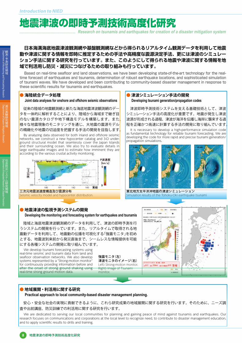
日本海溝海底地震津波観測網や基盤観測網などから得られるリアルタイム観測データを利用して地震動や津波に関する情報を即時に推定するための手法や高精度な震源決定手法、更には津波のシミュレーション手法に関する研究を行っています。また、このようにして得られる地震や津波に関する情報を地域で利活用し防災・減災につなげるための取り組みも行っています。
Based on real-time seafloor and land observations, we have been developing state-of-the-art technology for the real-time forecast of earthquakes and tsunamis, determination of robust earthquake locations, and sophisticated simulation of tsunami waves. We have developed and been contributing to community-based disaster management in response to these scientific results for tsunamis and earthquakes.
● 地域展開・利活用に関する研究Practical approach to local community-based disaster management planning.
安心・安全な社会の実現に貢献できるように、これら研究成果の地域展開に関する研究を行います。そのために、ニーズ調査や出前講座、防災訓練での利活用に関する研究を行います。
We are dedicated to serving our local communities for planning and gaining peace of mind against tsunamis and earthquakes. Our research focuses on communications and corporations at the local level to recognize need, to contribute to disaster management education, and to apply scientific results to drills and training.
● 地震津波の監視予測システムの開発Developing the monitoring and forecasting system for earthquakes and tsunamis
陸域と海底地震津波観測網のデータを利用して、津波の即時予測を行うシステムの開発を行っています。また、リアルタイムで取得される地震動データを利用して、地震動の伝播を可視化する「強震モニタ」を初めとする、地震波到来前から発災直後まで、シームレスな情報提供を可能にする各種システムの開発に取り組んでいます。
We develop tsunami forecasting systems using real-time seismic and tsunami data from land and seafloor observation networks. We also develop systems represented by a "Strong-motion monitor" for continuously providing information before and after the onset of strong ground shaking using real-time strong ground motion data.
強震モニタ(左)津波モニタのイメージ(右)Left) Strong-motion monitor. Right) Image of Tsunami monitor.
● 海陸統合データ処理Joint data analyses for onshore and offshore seismic observations
従来の陸域の地震観測網と新たな海底地震津波観測網のデータを一体的に解析することにより、陸域から海域まで継ぎ目のない震源カタログや地下構造モデルを構築します。また、様々な地震現象のモニタリングを通じ、大地震の震源モデルの精緻化や地震の切迫度を把握する手法の開発を目指します。
By analyzing data observed for both inland and offshore seismic networks, we construct a new hypocenter catalog and 3-D under-ground structural model that seamlessly cover the Japan Islands and their surrounding ocean. We also try to evaluate details in large earthquake images and to estimate how imminent they are according to the various crustal activity monitoring.
● 津波シミュレーション手法の開発Developing tsunami generation/propagation codes
津波即時予測技術システムを支える基礎技術として、津波シミュレーション手法の高度化が重要です。地震が発生し津波波源が形成される過程、津波が海洋を伝播し海岸に襲来する過程を正確かつ高速に計算する手法の開発に取り組んでいます。
It is necessary to develop a high-performance simulation code as fundamental technology for reliable tsunami forecasting. We are developing the code for more rapid and precise tsunami generation/propagation simulations.
三次元地震波速度構造及び震源分布Seismic velocity model and hypocenter distribution.
東北地方太平洋沖地震の津波シミュレーションSimulation results of the Tohoku-Oki earthquake tsunami
8
Introduction to NIED
観測・予測研究領域
Department of M
onitoring and Forecasting Research
減災実験研究領域
Department of Disaster M
itigation Research
社会防災システム研究領域
Department of Integrated Research on Disaster Prevention
地震津波の即時予測技術高度化研究
地震津波の即時予測技術高度化研究��������������� Research on tsunamis and earthquakes for creation of a disaster mitigation system

マグマの蓄積・移動から噴火・終息に至るまでの火山活動に関わる一連の評価・災害予測技術を開発研究します。噴火予測システムの高度化とリモートセンシング技術を用いて、マグマの蓄積や移動を捉えます。シミュレーションによって、噴火メカニズムを解明し、噴火に至った場合の災害を予測する技術を開発しています。
Our project seeks to develop systems to detect and observe magma accumulation and migration, to clarify the mechanism of volcanic eruption, and to predict volcanic hazards by numerical simulations and laboratory experiments.
● 噴火予測システムの高度化Eruption prediction system
基盤的火山観測網(V-net)で得られた地殻変動(GPS や傾斜計観測データ)や地震波形(広帯域地震計や高感度地震計観測データ)用い、マグマの蓄積や移動を自動的に検知し、変動源の位置や体積量を推定するシステムを高度化します。2011 年霧島山(新燃岳)の噴火では、これらのデータを利用してマグマの蓄積場所や噴火の推移を検出するのに成功しました。
Our goal is to develop an automatic, precise analysis system for magma accumulation and migration using crustal deformation data (GPS and tiltmeters) and seismic wave data (broadband and high-sensitivity seismographs) of the basic volcanic observation network (V-net). Using these observation data, we successfully detected the accumulation and migration of magma and eruption transitions.
2011年1月27日の霧島山(新燃岳)噴火Eruption of Kirishima-yama (Shinmoe-dake) on January 27, 2011
2011年1月26-27日の霧島山噴火に伴う傾斜変動Tilt change associated with the Kirishima-yama (Shinmoe-dake) eruption
GPSによって検出された霧島山火山活動に伴う地殻変動Crustal deformation associated with volcanic activity of Kirishima-yama detected by GPS
2011年1月26日霧島山噴火時に火山性地殻変動異常検知システムにより即時的に推定されたマグマ溜まりの場所Detected location of the magma reservoir at Kirishima-yama (Shinmoe-dake) by the automated system for ground deformation source estimation on January 26, 2011
2011年1月26-27日霧島山(新燃岳)噴火に伴う降灰分布図Isopleth map of the Kirishima-yama (Shinmoe-dake) eruption of January 26 and 27, 2011
9
観測・予測研究領域
Department of M
onitoring and Forecasting Research
減災実験研究領域
Department of Disaster M
itigation Research
社会防災システム研究領域
Department of Integrated Research on Disaster Prevention
火山活動の観測予測技術開発
������������������� Development of monitoring and forecasting technology for volcanic activity火山活動の観測予測技術開発
● 噴火メカニズムの解明と 噴火・災害予測シミュレーション技術開発
Numerical simulations of volcanic eruptions and disasters
● リモートセンシング技術による火山活動の把握Remote sensing of volcanoes
火山の熱的活動 Geothermal activity
火山活動に伴う地殻変動 Crustal deformation
噴火のメカニズムを理解して火山災害を効果的に軽減できるように、火山直下に蓄積したマグマが上昇・発泡して地表に流出するまでのさまざまな火山現象を、モデル化して数値シミュレーションを行っています。
We numerically simulated volcanic phenomena such as subsurface magma ascent and lava flow on the surface in order to understand the dynamics of volcanic eruptions and reduce the damage caused by them.
火山の活動状況を面的に把握するために、航空機搭載型ハイパースペクトルスキャナ(ARTS)や衛星搭載型合成開口レーダ(SAR)を用いた火山観測とその手法の開発を行っています。
We utilized an airborne hyperspectral scanner (ARTS) and a spaceborne synthetic aperture radar (SAR) to map changes resulting from volcanic activity.
静岡県東部地震(2011年3月15日)による富士山への影響評価に関する有限要素法シミュレーションFinite-element-method simulation for assessing the effect of the East Shizuoka Earthquake (March 15, 2011) on Mt. Fuji
リモートセンシングによる火山観測Volcano observation using remote sensing techniques
PALSAR/InSARにより検出された小笠原硫黄島の隆起分布Crustal deformation of Iwo-to detected by PALSAR/InSAR
2007/9/7-2006/10/30
2010/8/10-2006/10/30
ARTSで観測した阿蘇山の輝度温度画像と擬似カラー画像( 2010/11/20)ARTS brightness temperature images and false color image of Aso Volcano
富士山溶岩流のシミュレーションSimulated lava flow on Mt. Fuji
火道内におけるマグマ上昇流のシミュレーションSimulated magma ascent in a volcanic conduit
10
Introduction to NIED
観測・予測研究領域
Department of M
onitoring and Forecasting Research
減災実験研究領域
Department of Disaster M
itigation Research
社会防災システム研究領域
Department of Integrated Research on Disaster Prevention
火山活動の観測予測技術開発

日本全域にはりめぐらされた3種の地震計で、微動から強震動に至るさまざまな「揺れ」を正確に観測しています。また観測されたデータや処理結果は、ホームページを通じて公開され、地震調査研究に大いに役立てられています。
We accurately observe the earth’s shaking, from microseisms to strong motions, using three types of seismograph deployed throughout Japan. The collected seismic data and analyses are available to the public on the Internet.
● 強震観測網Strong-motion seismograph networks (K-NET and KiK-net)
K-NETは、全国約1000ヶ所に設置された、被害を及ぼすほど強い地震動を正確に捉える観測網です。また、Hi-net観測施設の地中と地表にも強震計が設置されており、KiK-netと呼ばれます。これらの強震データは、日本列島の地震被害リスク評価などに役立てられています。
K-NET is a network of strong-motion seismographs installed at approximately 1000 locations nationwide. K-NET is capable of recording strong and destructive seismic motions. One pair of strong-motion seismographs is also installed on and under the ground at each Hi-net observation site. These strong-motion seismographs collectively comprise KiK-net. Strong-motion data from both seismic networks are used to evaluate the risk of earthquake damage in the Japanese Islands.
K-NET強震計Strong-motion seismograph
K-NET観測施設Outlook of K-NET station
2011年東北地方太平洋沖地震における強震波形伝播Strong-motion wave propagation due to the Great East Japan Earthquake in 2011
孔井式H i-net 高感度地震計と観測井の構造Borehole-type Hi-net sensors and observation borehole
● 高感度地震観測網High-sensitivity seismograph network (Hi-net)
全国約800ヶ所に展開された高感度地震計で構成される観測網は、人体に感じないほど微弱な揺れも検知できます。観測データは24時間連続的にデータセンターに送られ、自動的震源決定処理により地震活動状況がモニタリングされています。また、リアルタイムで気象庁にも送られ、常時監視や2007年10月から一般国民への提供が開始された「緊急地震速報」にも利用されています。
Hi-net is an observation network composed of high-sensitivity seismographs deployed at approximately 800 locations nationwide. This network is capable of detecting seismic motions that are too weak to be felt by humans. The data are collected at the Data Center in Tsukuba and used for various seismic studies, including automatic hypocenter calculations. The data are also transmitted in real time to the Japan Meteorological Agency for use in the “Earthquake Early Warning” system.
日本列島を南から見た微小地震震源分布Distribution of microearthquakes viewed from the south of Japan
フィリピン海プレート沿いの地震Earthquakes along
the Philippine Sea plate
太平洋プレート沿いの地震Earthquakes along
the Pacific plate
11
観測・予測研究領域
Department of M
onitoring and Forecasting Research
減災実験研究領域
Department of Disaster M
itigation Research
社会防災システム研究領域
Department of Integrated Research on Disaster Prevention
地震・火山観測網
地震・火山観測網������������ Seismic and volcanic observation networks (Hi-net, F-net, K-NET, KiK-net, V-net and S-net)
● 広帯域地震観測網Broadband seismograph network (F-net)
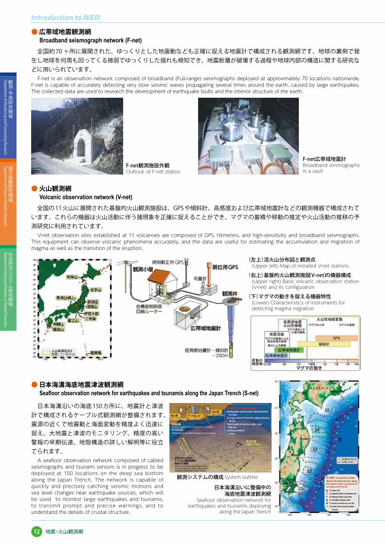
全国約 70 ヶ所に展開された、ゆっくりとした地震動なども正確に捉える地震計で構成される観測網です。地球の裏側で発生し地球を何周も回ってくる微弱でゆっくりした揺れも検知でき、地震断層が破壊する過程や地球内部の構造に関する研究などに用いられています。
F-net is an observation network composed of broadband (Full-range) seismographs deployed at approximately 70 locations nationwide. F-net is capable of accurately detecting very slow seismic waves propagating several times around the earth, caused by large earthquakes. The collected data are used to research the development of earthquake faults and the interior structure of the earth.
全国の 11 火山に展開された基盤的火山観測施設は、GPS や傾斜計、高感度および広帯域地震計などの観測機器で構成されています。これらの機器は火山活動に伴う諸現象を正確に捉えることができ、マグマの蓄積や移動の推定や火山活動の推移の予測研究に利用されています。
V-net observation sites established at 11 volcanoes are composed of GPS, tiltmeters, and high-sensitivity and broadband seismographs. This equipment can observe volcanic phenomena accurately, and the data are useful for estimating the accumulation and migration of magma as well as the transition of the eruption.
日本海溝沿いの海底 150 カ所に、地震計と津波計で構成されるケーブル式観測網が整備されます。震源の近くで地震動と海面変動を精度よく迅速に捉え、大地震と津波のモニタリング、精度の高い警報の早期伝達、地殻構造の詳しい解明等に役立てられます。
A seafloor observation network composed of cabled seismographs and tsunami sensors is in progress to be deployed at 150 locations on the deep sea bottom along the Japan Trench. The network is capable of quickly and precisely catching seismic motions and sea level changes near earthquake sources, which will be used to monitor large earthquakes and tsunamis, to transmit prompt and precise warnings, and to understand the details of crustal structure.
● 火山観測網Volcanic observation network (V-net)
● 日本海溝海底地震津波観測網Seafloor observation network for earthquakes and tsunamis along the Japan Trench (S-net)
F-net観測施設外観Outlook of F-net station
F-net広帯域地震計Broadband seismographs in a vault
(左上)活火山分布図と観測点(Upper left) Map of installed V-net stations
(右上)基盤的火山観測施設(V-net)の機器構成(Upper right) Basic volcanic observation station (V-net) and its configuration
(下)マグマの動きを捉える機器特性(Lower) Characteristics of instruments for detecting magma migration
日本海溝沿いに整備中の海底地震津波観測網
Seafloor observation network for earthquakes and tsunamis deploying
along the Japan Trench
観測システムの構成 System outline
12
Introduction to NIED
観測・予測研究領域
Department of M
onitoring and Forecasting Research
減災実験研究領域
Department of Disaster M
itigation Research
社会防災システム研究領域
Department of Integrated Research on Disaster Prevention
地震・火山観測網

ミリ波レーダ
XバンドMPレーダ
気候変動に伴い増加が懸念される極端気象によって複合的に発生する水害等を軽減するため、その発生メカニズムの解明と災害予測に関する研究開発を進めます。
We are studying the mechanism of water-related hazards that occur in complex ways. Our final goal is to develop a forecast system contributing to the mitigation of water-related disasters caused by extreme weather.
● 局地豪雨の早期予測技術の開発Development of forecasting techniques for localized heavy rainfall
防災科研で開発された X バンドマルチパラメータレーダ(MPレーダ)やミリ波レーダなど、様々な気象観測装置を用いた積乱雲の観測を行い、これらの観測データを利用した予測手法の開発を行っています。
We are carrying out observations and developing methods of predicting severe storms based on data from X-band multi-parameter (MP) radars, millimeter-wavelength radars, which have been developed in NIED, and other instruments.
積乱雲の発達過程に応じた観測の概念図Schematic diagram of observations of different development stages of a thunder storm
3次元地盤モデルによる斜面安定性の評価技術と斜面モニタリングを用いた評価技術の開発Development of a slope stability analysis using a three-dimensional subsurface model and a method of monitoring the slope condition
XバンドMPレーダによって観測された高度 1 km における降雨強度(色)と風(矢羽)の観測例Rainfall intensity (color shaded) and wind (barbs) at a 1-km height observed by X-band radars
大型降雨実験施設を用いた、斜面崩壊のメカニズム解明とモニタリングセンサー開発Study of landslide mechanisms and development of a slope-failure warning sensor using the large-scale rainfall simulator
● 豪雨と地震による複合土砂災害の危険度評価技術の開発Risk estimation of landslides caused by heavy rainfall and earthquake
地下地盤構造を反映した3次元地盤モデルを構築し、集中豪雨など降雨現象および地下水挙動に加えて地震動の影響も考慮できる土砂災害の危険度評価技術の開発を進めています。
We are developing a "three-dimensional subsurface model" that monitors the condition of ground water, for a risk estimation of landslides caused by heavy rainfall and earthquake.
13
観測・予測研究領域
Department of M
onitoring and Forecasting Research
減災実験研究領域
Department of Disaster M
itigation Research
社会防災システム研究領域
Department of Integrated Research on Disaster Prevention
都市圏における複合水災害の発生予測に関する研究
都市圏における複合水災害の発生予測に関する研究�������������������� Research on prediction of complex water-related disasters in urban areas
現 象 観測・モデル 研究成果 社会に役立つ成果
Phenomena Observation and modeling Results Social experiments
①東京23区浸水
リアルタイム予測
②都市河川の急激な水位上昇の
発生機構解明とその予測
東京23区浸水予測 水防活動支援(迅速な出動
態 勢、二 次 災害の防災)
[河川管理者の情報把握、住民への警報]
発生機構解明と予測モデル開発
機動的観測河川定点観測
● 沿岸災害の予測技術と危険度評価技術の開発Development of a technique for estimating and predicting coastal hazards
● 局地的豪雨による都市水害のリアルタイム予測手法の開発Development of techniques for forecasting urban floods
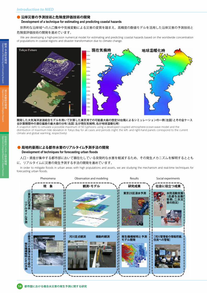
世界的な沿岸域への人口集中や気候変動による災害の変質を踏まえ、高精度の数値モデルを活用した沿岸災害の予測技術と危険度評価技術の開発を進めています。
We are developing a high-precision numerical model for estimating and predicting coastal hazards based on the worldwide concentration of populations in coastal regions and disaster transformation due to climate change.
人口・資産が集中する都市部において顕在化している突発的な水害を軽減するため、その発生メカニズムを解明するとともに、リアルタイムに災害の発生予測する手法の開発を進めています。
In order to mitigate floods in urban areas with high populations and assets, we are studying the mechanism and real-time techniques for forecasting urban floods.
開発した大気海洋波浪結合モデルを用いて計算した東京湾での可能最大級の想定50台風によるシミュレーションの一例(左図)とその全ケース全計算期間中の潮位偏差の最大値の分布(右図:左が現在気候時、右が地球温暖化時)A snapshot (left) to simulate a possible maximum of 50 typhoons using a developed coupled atmosphere-ocean-wave model and the distribution of maximum tide deviation in Tokyo Bay for all cases and periods (right: the left- and right-hand panels correspond to the current climate and global warming, respectively)
14
Introduction to NIED
観測・予測研究領域
Department of M
onitoring and Forecasting Research
減災実験研究領域
Department of Disaster M
itigation Research
社会防災システム研究領域
Department of Integrated Research on Disaster Prevention
都市圏における複合水災害の発生予測に関する研究

局地性の強い雪氷災害に対応するために、レーダー等による降雪の高精度観測手法、降雪種・湿雪対応の積雪構造モデル、これらを基礎とする雪崩・吹雪・着雪災害予測手法を開発するとともに、雪氷災害リアルタイムハザードマップの開発を行っています。
In order to mitigate the damage caused by snow disasters with spatial variability, we are developing an advanced technique for observing precipitation using meteorological radars as well as developing a snow cover model that includes wet snow metamorphism. Based on these studies, methods of forecasting snow avalanche, blowing snow, and snow accretion are being developed, which will be applied to the real-time hazard mapping of snow disasters.
● 降雪の観測と予測に関する研究Study on monitoring and prediction of snowfall
雪氷災害を軽減するためには、精度の高い降雪予測(いつ、どこに、どの様な雪がどれだけ降るか)が重要です。そのため、降雪粒子の成長モデルを開発し予測方法を改良しています。また、偏波機能を持つレーダーと積雪・気象観測ネットワークなど地上観測点による降積雪の監視システムを構築し、予測方法の検証を行っています。あられや雪片などの降雪粒子の種類の連続観測も行い、降雪粒子成長モデルの高度化を進めています。
Reliable prediction of snowfall is important for mitigation of damage arising from snow-related disasters. We are improving snowfall simulation with a detailed cloud model incorporating a snow particle growth algorithm. We conduct Multi-Phase Precipitation Radar, surface snow, and weather observations for validation of the simulation. Continuous observation of snow particle types is also carried out to improve the snow particle growth algorithm.
偏波機能を持つ“多相降水レーダー”Multi-Phase Precipitation Radar capable of obtaining various polarimetric parameters
積雪・気象観測ネットワークの守門大平観測点(標高:518m)Sumon-Oodaira station (518 m.a.s.l.) of the Snow and Weather Observation Network
レーダーで観測したある瞬間の降雪強度(左)と同じ時刻のモデルによる予測値(右)Snowfall intensity by radar observation (left) and its prediction at the corresponding time (right)
防風ネットを備えた降雪粒子観測施設Falling snow observatory surrounded by a wind-shielding net
15
観測・予測研究領域
Department of M
onitoring and Forecasting Research
減災実験研究領域
Department of Disaster M
itigation Research
社会防災システム研究領域
Department of Integrated Research on Disaster Prevention
高度降積雪情報に基づく雪氷災害軽減研究
高度降積雪情報に基づく雪氷災害軽減研究���������������� Research on advanced snow information and its application to disaster mitigation

雪崩発生
● 積雪変質の予測に関する研究Study on forecasting snow metamorphism
● 雪氷災害発生機構のモデル化とリアルタイムハザードマップの開発 Modeling the mechanism of snow-related hazards and developing real-time snow hazard maps
積雪深や密度、雪質などの積雪状態の情報は、雪氷災害の発生を予測するためには不可欠です。しかし、実際に観測によってそれらの情報を広範囲で得ることは困難です。そこで、数値モデル(積雪変質モデル)を用いて気象条件の変化に伴う積雪の変質を精度よく予測するための研究を行っています。特に融雪期の雪氷災害発生予測に欠かせない積雪内部での水の移動のモデル化に関する研究(観測・実験)を重点的に行っています。
Although snow conditions, such as snow depth, density, and snow type, are necessary for forecasting snow disasters, it is difficult to obtain their spatiotemporal variation observationally. We are developing a numerical model to predict changes in snow properties from meteorological data. In particular, we are focusing on the process of water transportation in the snow cover.
重大な事故の原因や円滑な交通の妨げとなる雪崩や吹雪、ライフラインに障害をもたらす着雪氷などの発生メカニズムを解明するため、室内実験や野外観測を行っています。それらをもとに、災害発生と降雪や積雪の状態、気温などの気象条件との関係を明らかにし、災害を予測するためのモデル開発を進めています。これらのモデルは雪氷災害リアルタイムハザードマップの作成に応用されます。
Snow avalanches and blowing snow cause serious accidents and prevent smooth traffic flow in snowy regions. Snow accretion sometimes leads to malfunction of life lines. The mechanisms of these phenomena, especially their dependency on snowfall, snow cover, and meteorological conditions, are being investigated by experiments and field observations. On the basis of the results, models to predict the potential hazards caused by these phenomena are being developed, and they are being applied to real-time snow hazard mapping.
積雪の内部構造の観測Observation of snow cover structure
積雪のしもざらめ化に伴うせん断強度変化の低温室実験Measurements of snow shear strength in the cold laboratory at various development stages of depth hoar
吹雪の発達過程や構造を調べるための風洞実験Wind-tunnel experiment to investigate the mechanism and structure of blowing snow
吹雪モデルによる視程の予測例An example of visibility forecasting using a blowing snow model (Niigata Pref.)
電線を用いた着雪実験Snow accretion experiment in the cold wind-tunnel
低温室における積雪内部の水の移動に関する実験Cold laboratory experiments on water movement in the snow cover
積雪変質モデルで得られた雪崩発生時の積雪安定度の時間変化Temporal change in the stability index obtained by a numerical snow cover model at snow avalanche release
積雪変質モデルを用いて計算した雪質と含水率の時間変化Simulation results of grain type and water content using a numerical snow cover model
積雪深を考慮した雪崩ハザードマップAvalanche hazard map considering snow depth variation
○ 雪崩の予測
○ 吹雪と視程障害の予測 ○ 着雪の予測
16
Introduction to NIED
観測・予測研究領域
Department of M
onitoring and Forecasting Research
減災実験研究領域
Department of Disaster M
itigation Research
社会防災システム研究領域
Department of Integrated Research on Disaster Prevention
高度降積雪情報に基づく雪氷災害軽減研究

E-ディフェンスを利用して、実物大もしくは大型の構造物試験体に地震動を作用させることにより、地震が発生した時に、構造物がどのように破壊するのかを解明します。また、得られた実験データは、土木建築構造物の耐震技術の確立・検証に活用されています。
Utilizing E-Defense, earthquake motions are input to test structures to investigate their failure processes and mechanisms during and after earthquakes. Based on data obtained from the tests, more advanced technologies are established and verified in order to mitigate earthquake damage to structures.
● 鉄筋コンクリート建物Reinforced concrete buildings
● 木造建物Wooden houses
最新の方式で設計された 2 体の試験体を用意しました。1 体は、従来の鉄筋コンクリート工法を、もう 1 体は、PC 圧着工法と呼ばれる、工場生産された部品を組み立ててワイヤーで部品同士を締め付けることで接合する工法を用いて建設した建物です。1995 年兵庫県南部地震の地震波を再現した実験を行ったところ、どちらの建物も粘り強さを発揮し、優れた耐震性能を保有していることが確認できました。
The test employed two test buildings: a reinforced concrete building designed based on the latest method and a pre-stressed concrete building constructed by assembling the components fabricated in plants with steel wires. The test buildings were excited with the 1995 Kobe Earthquake. As a result, it was verified that both buildings have good ductility and excellent seismic performance.
築30年の2階建て木造住宅2棟を震動台上に移築し、耐震補強を行ったものと無補強のものを同時に加振する比較実験を行い、倒壊過程の解明と耐震補強の有効性の検証を行いました。本実験により、1995 年兵庫県南部地震規模の地震に対しても、適切な補強を行うことで、古い木造住宅の倒壊を防げることが明らかとなりました。
Two 30-year-old two-story wooden houses were disassembled and reassembled on an E-Defense shaking table. One of the houses was reinforced, and the other was not. The two houses were placed on the shaking table and tested simultaneously in order to clarify collapse process of the wooden houses and to verify the effects of the seismic reinforcement method. In conclusion, fatal collapse of old wooden houses is avoidable even in 1995 Kobe Earthquake by appropriate reinforcement.
PC圧着工法の工事の様子:工場生産の部品を運び込み、クレーンで吊り、組立てるConstruction of the pre-stressed concrete test building: Pre-cast building elements were assembled at the site
在来工法による鉄筋コンクリート造建物の工事の様子Construction of the conventional reinforced concrete test building
試験体の様子:2体の建物(高さ13.5m x 幅9m x 奥行16m)を同時に実験View of the test buildings: The two buildings (height: 13.5 m, width: 9 m, and depth: 16 m) were tested simultaneously
明石市より移築される住宅Houses moved from Akashi-City
震動台上に移築された住宅(左:無補強、右:補強有り)Reassembled houses on the shaking table (left: unreinforced, right: reinforced)
実験後の住宅(左:無補強、右:補強有り)Houses after the experiment (left: unreinforced, right: reinforced)
17
観測・予測研究領域
Department of M
onitoring and Forecasting Research
減災実験研究領域
Department of Disaster M
itigation Research
社会防災システム研究領域
Department of Integrated Research on Disaster Prevention
実大三次元震動破壊実験施設(E-ディフェンス)を活用した社会基盤研究
実大三次元震動破壊実験施設(E-ディフェンス)を活用した社会基盤研究������������������Earthquake engineering research utilizing the 3-D Full-Scale Earthquake Testing Facility (E-Defense)
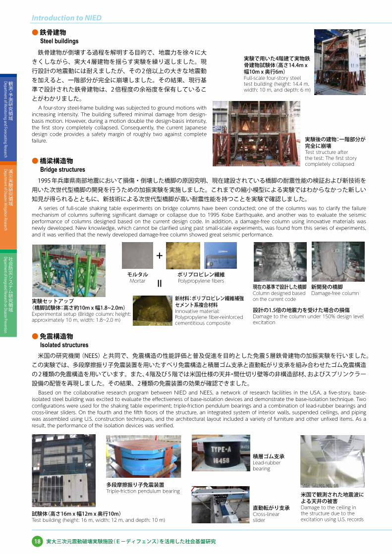
● 鉄骨建物Steel buildings
● 橋梁構造物Bridge structures
● 免震構造物Isolated structures
鉄骨建物が倒壊する過程を解明する目的で、地震力を徐々に大きくしながら、実大 4 層建物を揺らす実験を繰り返しました。現行設計の地震動には耐えましたが、その 2 倍以上の大きな地震動を加えると、一階部分が完全に崩壊しました。その結果、現行基準で設計された鉄骨建物は、2 倍程度の余裕度を保有していることがわかりました。
A four-story steel-frame building was subjected to ground motions with increasing intensity. The building suffered minimal damage from design-basis motion. However, during a motion double the design-basis intensity, the first story completely collapsed. Consequently, the current Japanese design code provides a safety margin of roughly two against complete failure.
1995 年兵庫県南部地震において損傷・倒壊した橋脚の原因究明、現在建設されている橋脚の耐震性能の検証および新技術を用いた次世代型橋脚の開発を行うための加振実験を実施しました。これまでの縮小模型による実験ではわからなかった新しい知見が得られるとともに、新技術による次世代型橋脚が高い耐震性能を持つことを実験で確認しました。
A series of full-scale shaking table experiments on bridge columns have been conducted; one of the columns was to clarify the failure mechanism of columns suffering significant damage or collapse due to 1995 Kobe Earthquake, and another was to evaluate the seismic performance of columns designed based on the current design code. In addition, a damage-free column using innovative materials was newly developed. New knowledge, which cannot be clarified using past small-scale experiments, was found from this series of experiments, and it was verified that the newly developed damage-free column showed great seismic performance.
米国の研究機関(NEES)と共同で、免震構造の性能評価と普及促進を目的とした免震 5 層鉄骨建物の加振実験を行いました。この実験では、多段摩擦振り子免震装置を用いたすべり免震構造と積層ゴム支承と直動転がり支承を組み合わせたゴム免震構造の 2 種類の免震構造を用いています。また、4 階及び 5 階では米国仕様の天井・間仕切り壁等の非構造部材、およびスプリンクラー設備の配管を再現しました。その結果、2 種類の免震装置の効果が確認できました。
Based on the collaborative research program between NIED and NEES, a network of research facilities in the USA, a five-story, base-isolated steel building was excited to evaluate the effectiveness of base-isolation devices and demonstrate the base-isolation technique. Two configurations were used for the shaking table experiment; triple-friction pendulum bearings and a combination of lead-rubber bearings and cross-linear sliders. On the fourth and the fifth floors of the structure, an integrated system of interior walls, suspended ceilings, and piping was assembled using U.S. construction techniques, and the architectural layout included a variety of furniture and other unfixed items. As a result, the performance of the isolation devices was verified.
実験で用いた4階建て実物鉄骨建物試験体(高さ14.4m x 幅10m x 奥行6m)Full-scale four-story steel test building (height: 14.4 m, width: 10 m, and depth: 6 m)
実験後の建物:一階部分が完全に崩壊Test structure after the test: The first story completely collapsed
実験セットアップ(橋脚試験体:高さ約10m x 幅1.8~2.0m)Experimental setup (Bridge column: height: approximately 10 m, width: 1.8~2.0 m)
モルタルMortar
試験体(高さ16m x 幅12m x 奥行10m)Test building (height: 16 m, width: 12 m, and depth: 10 m)
多段摩擦振り子免震装置Triple-friction pendulum bearing
積層ゴム支承Lead-rubber bearing
直動転がり支承Cross-linear slider
米国で観測された地震波による天井の被害Damage to the ceiling in the structure due to the excitation using U.S. records
ポリプロピレン繊維Polypropylene fibers
新材料:ポリプロピレン繊維補強セメント系複合材料Innovative material: Polypropylene fiber-reinforced cementitious composite
現在の基準で設計した橋脚Column designed based on the current code
新開発の橋脚Damage-free column
設計の1.5倍の地震力を受けた場合の損傷Damage to the column under 150% design level excitation
+
=
18
Introduction to NIED
観測・予測研究領域
Department of M
onitoring and Forecasting Research
減災実験研究領域
Department of Disaster M
itigation Research
社会防災システム研究領域
Department of Integrated Research on Disaster Prevention
実大三次元震動破壊実験施設(E-ディフェンス)を活用した社会基盤研究

19
観測・予測研究領域
Department of M
onitoring and Forecasting Research
減災実験研究領域
Department of Disaster M
itigation Research
社会防災システム研究領域
Department of Integrated Research on Disaster Prevention
災害リスク情報に基づく社会防災システム研究
自然災害を軽減するためには、個人や地域、国が、それぞれ自らの「防災」を計画・実行することが重要です。その根拠となる質の高いハザード・リスク情報を、地震災害をはじめとした各種災害に関して作成・公開し、その情報を活用する利便性の高いシステムを提供するため、ユーザーの意見を積極的に取り入れつつ、研究を推進しています。また、システムを利活用していく過程で得られた知見を活かし、さらに災害に強い社会づくりに取り組んでいます。
In order to mitigate the damage caused by natural disasters, it is very important to enable planning and execution for each subject, that is to say residents, organizations and governments. To achieve this objective, the project is developing a system that can provide reliable disaster risk information to each subject in such a way that they can recognize and manage disaster prevention measures as realistically as possible. First, we collect various data pertaining to different regulatory and research organizations associated with natural disasters. Then, we sort and clarify these data into a comprehensive database that can be easily understood and used by individual residents. The latest Web GIS technology will be utilized to disseminate comprehensive risk information widely and intelligibly to all stakeholders involved in disaster risk governance.
ハザード評価・ハザードマップ作成にはじまり、リスク評価、様々なアプリケーション開発、利活用の実証実験まで、社会全体の領域にわたって幅広く取り組んでいます。
In this project, we conduct hazard evaluation, elaboration of hazard map systems, risk assessment, applications development, and utilization of all these data and systems over society as a whole.
災害リスク情報に基づく社会防災システム研究���������������������������������������������� Research on a social disaster prevention system
災害リスク情報の
流通
20
Introduction to NIED
観測・予測研究領域
Department of M
onitoring and Forecasting Research
減災実験研究領域
Department of Disaster M
itigation Research
社会防災システム研究領域
Department of Integrated Research on Disaster Prevention
災害リスク情報に基づく社会防災システム研究
● 自然災害に対するハザード・リスク評価に関する研究Research on evaluation of hazard and risk of natural disasters
○ 地震ハザード・リスク情報ステーションSeismic hazard and risk information station
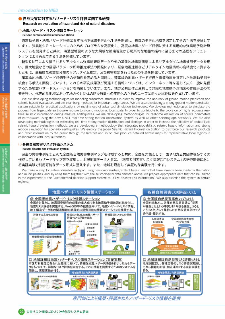
強震動予測・地震ハザード評価に資する地下構造モデル化手法を開発し、複数のモデル地域を選定してその手法を検証しています。強震動シミュレーションのためのプログラムを高度化し、高度な地震ハザード評価に資する実用的な強震動予測計算システムを開発すると共に、海溝型地震のような大規模な破壊現象から局所的な地盤の揺れに至るまでの過程をシミュレーションにより再現できる手法を開発しています。 新型 K-NET により得られるリアルタイム強震動観測データや他の基盤的地震観測網によるリアルタイム地震波形データを用い、巨大地震などの震源パラメータ即時推定手法の開発により、緊急地震速報などリアルタイム地震情報の高精度化に資するとともに、高精度な強震動分布のリアルタイム推定、及び被害推定を行うための手法を開発しています。 確率論的地震ハザード評価手法の信頼性を高めると同時に、確率論的地震ハザード評価と震源断層を特定した地震動予測を統合する手法を開発しています。これらの研究成果及び関連する情報については、インターネット等を通じて広く一般に発信するため地震ハザードステーションを構築しています。また、地方公共団体と連携して詳細な地震動予測地図の作成手法の開発を行い、代表的な地域において地方公共団体の防災行政への実用化のためのニーズに沿った試作版を作成しています。
We are developing methodologies for modeling subsurface structures in order to improve the accuracy of ground motion prediction and seismic hazard evaluation, and are examining methods for important target areas. We are also developing a strong ground motion prediction system suitable for practical applications by making use of advanced simulation techniques. We develop methodologies to simulate the process from large-scale earthquake rupture to ground motion at local scale. In order to contribute to the provision of highly accurate real-time seismic information during massive earthquakes, we are developing methodologies for real-time estimation of source parameters of earthquakes using the new K-NET real-time strong motion observation system as well as other seismograph networks. We are also developing methodologies for estimating real-time strong motion distribution and damage. In order to increase the reliability of probabilistic seismic hazard evaluation methods, we are developing a methodology that integrates probabilistic seismic hazard information and strong motion simulation for scenario earthquakes. We employ the Japan Seismic Hazard Information Station to distribute our research products and other information to the public through the Internet and so on. We produce detailed hazard maps for representative local regions in collaboration with local authorities.
○ 各種自然災害リスク評価システムNatural disaster risk evaluation system
過去の災害事例をまとめた全国版自然災害事例マップを作成すると共に、全国を対象として、国や地方公共団体等がすでに作成しているハザードマップ等を収集し、上記地震データと共に、「利用者別災害リスク情報活用システム」の研究開発における実証実験で利用可能なデータ形式に整えます。また、地域を限定して実証的な実験を行います。
We make a map for natural disasters in Japan using previous disasters, collect hazard maps that have already been made by the nation and municipalities, and, by using them together with the seismological data denoted above, we prepare appropriate data that can be utilized in the experiment of the “user-oriented decision support system to utilize disaster risk information.” We also examine the system in certain regions.

21
観測・予測研究領域
Department of M
onitoring and Forecasting Research
減災実験研究領域
Department of Disaster M
itigation Research
社会防災システム研究領域
Department of Integrated Research on Disaster Prevention
災害リスク情報に基づく社会防災システム研究
● 災害リスク情報の利活用に関する研究Research and development of utilization of disaster risk information
行政、研究機関等が作成した各種災害のハザードマップやリスク情報(被害想定、危険度マップ等)を分散相互運用環境で活用し、地域社会が自らリスクを評価し対策を検討・実施することを支援する手法と情報システムを開発しています。
We are developing methods and an information system in order to help regional communities evaluate natural disaster risks and implement countermeasures using hazard and risk information such as anticipated damage area maps and hazard maps, which are delivered through an interoperable environment of geo-spatial information.
○ 防災マップ作成システムMapping system for disaster prevention
ハザードマップ等を下敷きに地域固有の防災資源や危険箇所を統合し、議論を踏まえて防災マップを作成するための手法と情報システムの研究開発を行っています。
We developed a method and information system so that regional communities can make disaster prevention maps that integrate the knowledge of specialists and local people about dangerous areas through discussions or workshops.
○ 地域防災キットの開発Development of a local disaster prevention tool kit
地域内外の様々な情報の連携および流通、発信、コミュニケーションを促進する情報基盤として「e コミュニティ・プラットフォーム」の研究開発に取り組んでいます。これを基盤に、地域自ら防災マップや防災ラジオドラマ等の作成を支援するツールとして「地域防災キット」の研究開発を行っています。
We develop the web-based groupware “e-community platform” as an information basis for promoting the exchange and dispatch of information as well as communication. Based on this groupware, the “regional disaster prevention tool kit” was developed as a supporting tool for creating disaster prevention maps, radio dramas, and so on.
○ 地域発・防災ラジオドラマLocally made radio drama for disaster prevention
地域に将来起こりうる災害をシナリオ化したラジオドラマを、地域の多様な主体と協働で制作することを通じて、地域の防災力を高める手法の研究開発を行っています。
This is a method to enhance disaster prevention ability in local areas through the experience of making a disaster radio drama based on the scenario of possible disasters.
eコミマップで作った防災マップとワークショップの様子 ドラマ台本の執筆とドラマ収録風景

● 東日本大震災の災害アーカイブとその利活用に関する研究開発Research and development of Great East Japan Earthquake and Tsunami Disaster Archive and its Utilization and Application.
東日本大震災の経験や教訓を人類共通の財産として後世に伝承し、安全な社会づくりを行うために、官民協働で被災前・災害発生時・復興過程を記録します。記録したデータ及びアーカイブ活動は、被災地でのコミュニティ再生支援、産業・雇用の創出や、防災教育や防災政策・対策の見直しなどで活用いたします。
We archive pre, during, and post disaster processes through public-private partnership efforts to make safer future societies. The archive plays a role in passing on our experience and lessons learned from the Great East Japan Earthquake and Tsunami Disaster in 2011 to the next generation as our common property resources. We also utilize the archive for assisting communities’ recovery, creating industries and jobs, and re-examining education, policies, and countermeasures for disaster mitigation.
● 自治体向け災害対応システムに関する研究開発Research and development of crisis management cloud systems with public and private cooperation
各種災害に対する地方公共団体等の危機管理システムとして、分散相互運用環境により、官民の各機関からリアルタイムで災害情報を取得して各種情報を統合化して状況把握と事態の推移の見通しを把握した上で、災害対応を支援する情報システムを開発します。
We are developing an information system for natural disaster crisis management for municipalities. This information system helps to obtain real-time information through an interoperable environment of geo-spatial information. Integrating disaster information, the municipality can grasp current situations correctly and foresee future conditions.
22
Introduction to NIED
観測・予測研究領域
Department of M
onitoring and Forecasting Research
減災実験研究領域
Department of Disaster M
itigation Research
社会防災システム研究領域
Department of Integrated Research on Disaster Prevention
災害リスク情報に基づく社会防災システム研究
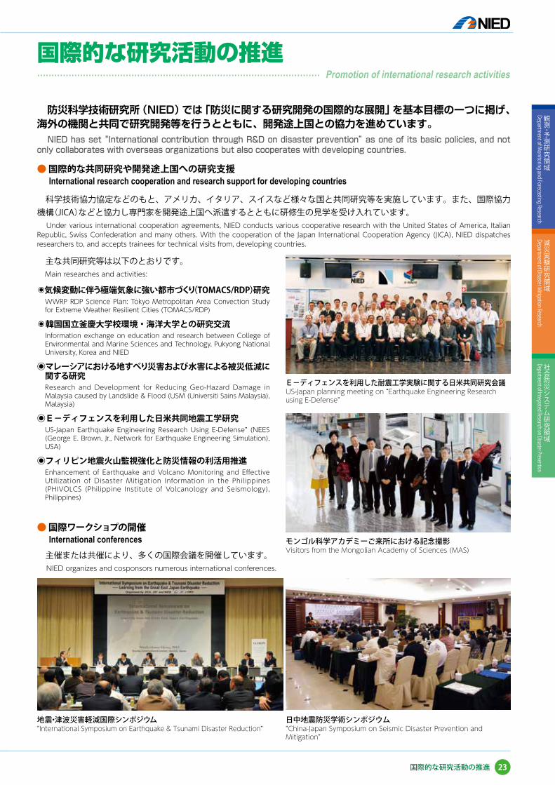
防災科学技術研究所(NIED)では「防災に関する研究開発の国際的な展開」を基本目標の一つに掲げ、海外の機関と共同で研究開発等を行うとともに、開発途上国との協力を進めています。
NIED has set “International contribution through R&D on disaster prevention” as one of its basic policies, and not only collaborates with overseas organizations but also cooperates with developing countries.
● 国際的な共同研究や開発途上国への研究支援 International research cooperation and research support for developing countries
● 国際ワークショプの開催International conferences
科学技術協力協定などのもと、アメリカ、イタリア、スイスなど様々な国と共同研究等を実施しています。また、国際協力機構(JICA)などと協力し専門家を開発途上国へ派遣するとともに研修生の見学を受け入れています。
Under various international cooperation agreements, NIED conducts various cooperative research with the United States of America, Italian Republic, Swiss Confederation and many others. With the cooperation of the Japan International Cooperation Agency (JICA), NIED dispatches researchers to, and accepts trainees for technical visits from, developing countries.
主催または共催により、多くの国際会議を開催しています。NIED organizes and cosponsors numerous international conferences.
モンゴル科学アカデミーご来所における記念撮影Visitors from the Mongolian Academy of Sciences (MAS)
日中地震防災学術シンポジウム“China-Japan Symposium on Seismic Disaster Prevention and Mitigation”
主な共同研究等は以下のとおりです。Main researches and activities:
◉気候変動に伴う極端気象に強い都市づくり(TOMACS/RDP)研究
WWRP RDP Science Plan: Tokyo Metropolitan Area Convection Study for Extreme Weather Resilient Cities (TOMACS/RDP)
◉韓国国立釜慶大学校環境・海洋大学との研究交流Information exchange on education and research between College of Environmental and Marine Sciences and Technology, Pukyong National University, Korea and NIED
◉マレーシアにおける地すべり災害および水害による被災低減に関する研究Research and Development for Reducing Geo-Hazard Damage in Malaysia caused by Landslide & Flood (USM (Universiti Sains Malaysia), Malaysia)
◉E-ディフェンスを利用した日米共同地震工学研究US-Japan Earthquake Engineering Research Using E-Defense” (NEES (George E. Brown, Jr., Network for Earthquake Engineering Simulation), USA)
◉フィリピン地震火山監視強化と防災情報の利活用推進 Enhancement of Earthquake and Volcano Monitoring and Effective Utilization of Disaster Mitigation Information in the Philippines (PHIVOLCS (Philippine Institute of Volcanology and Seismology), Philippines)
E-ディフェンスを利用した耐震工学実験に関する日米共同研究会議US-Japan planning meeting on “Earthquake Engineering Research using E-Defense”
地震・津波災害軽減国際シンポジウム“International Symposium on Earthquake & Tsunami Disaster Reduction”
23
観測・予測研究領域
Department of M
onitoring and Forecasting Research
減災実験研究領域
Department of Disaster M
itigation Research
社会防災システム研究領域
Department of Integrated Research on Disaster Prevention
国際的な研究活動の推進
国際的な研究活動の推進��������������������������������� Promotion of international research activities

● 国際的な地震ハザード・リスク評価に関する共同研究の本格化Development of international seismic hazard and risk assessment accelerated
フィリピンにおいて同国火山地震研究所および日本国内の大学等と共同で広帯域地震観測と震度観測、津波情報の高度化、GPS 観測と地質調査による地震発生ポテンシャル評価、タール火山とマヨン火山の観測・監視システムの構築を行っています。これらのリアルタイム地震火山情報の発信と簡易耐震診断ツール、東日本大震災のフィリピン人津波被災者インタビューなどの防災教育ツールの提供を通じてフィリピンの国・自治体・コミュ二ティーの防災力向上に貢献しています。
NIED, in collaboration with PHIVOLCS and Japanese universities, install real-time broadband and seismic intensity networks, conduct GPS measurement and geological survey to evaluate earthquake generation potential, install real-time monitoring systems of Taal and Mayon volcanoes. We provide the realtime earthquake and volcano information in timely manner, as well as educational tools such as simple seismic diagnosis of houses and interviews of Philippino victims by the 2011 Great East Japan Eartthquake, in order to contribute to disaster preparedness of the national, local governments, and communities of the Philippines.
東日本大震災の教訓を踏まえ、防災科研では、地震ハザード・リスク評価に関する共同研究を、アジア地域、特に中国、韓国、台湾等で進めています。アジア地域の地域特性を考慮した評価モデルの高度化が期待されています。
NIED accelerated the cooperative studies of seismic hazard and risk assessments (SHRA) with colleagues in China, Korea, Taiwan and the rest of Asia based on the lessons learnt from Tohoku M 9.0 earthquake. The advanced SHRA models with localizations will be expected in the future.
GEM(Global Earthquake Model Foundation)は、地震ハザード・リスク評価手法の開発や、関連する情報基盤の構築を目指した活動を推進している国際的な NPO 組織です。GEM からの要請をうけ、防災科研は運営委員会メンバーとして GEM に参画しました。日本において培われた地震ハザード・リスク評価に関する研究成果は、国際的な組織 GEM を通じて世界に向け発信されます。
GEM(Global Earthquake Model Foundation) is an international NPO of SHRA under the activities of OCED. As a representative of Japan, NIED proudly joined GEM since its SHRA’s methodologies and technologies were highly valuated. NIED delivers its experiences, lessons and knowledge to the world through GEM.
タール火山における観測機材の設置Installation of equipments at Taal volcano.
GEMに全面参画NIED joined GEM during 15WCEE (bottom).
● フィリピン地震火山監視強化と防災情報の利活用推進(地球規模課題対応国際科学技術協力)“Enhancement of Earthquake and Volcano Monitoring and Effective Utilization of Disaster Mitigation Information in the Philippines”(SATREPS)
フィリピン人被災者ビデオインタビューInterview of Philippino victims of Great East Japan Earthquake.
韓国のチェジュ島にて第二回日中韓交流会Second SHRA annual meeting was hosted in Jeju Korea 2012(top).
カタンドゥアネス島での地震計設置Installation of seismometer at Catanduanes Island
24
Introduction to NIED
観測・予測研究領域
Department of M
onitoring and Forecasting Research
減災実験研究領域
Department of Disaster M
itigation Research
社会防災システム研究領域
Department of Integrated Research on Disaster Prevention
国際的な研究活動の推進
● Web ページからの情報発信Providing information on NIED's website. http://www.bosai.go.jp
● 常設展示Exhibits
● 出版物Publications
研究所で得られた成果は、インターネット等を通じて広く公開されています。
Research outputs are widely open to the public on the Internet.
・観測データ Observation data地震・火山・気象・雪氷などの観測データ及び解析結果Observation data and analyzed results on earthquake, volcano, meteorological phenomenon, snow and ice.
・研究成果等データ一覧Data list of research results and others.
・防災科学技術研究所年報Annual Report of the National Research Institute for Earth Science and Disaster Prevention.
・twitter や YouTube による情報発信Providing information by twitter and Youtube.
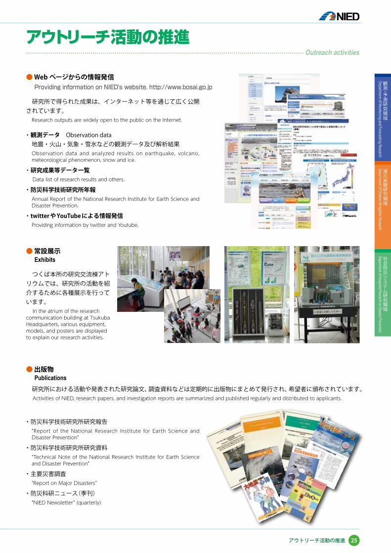
つくば本所の研究交流棟アトリウムでは、研究所の活動を紹介するために各種展示を行っています。
In the atrium of the research communication building at Tsukuba Headquarters, various equipment, models, and posters are displayed to explain our research activities.
研究所における活動や発表された研究論文、調査資料などは定期的に出版物にまとめて発行され、希望者に頒布されています。Activities of NIED, research papers, and investigation reports are summarized and published regularly and distributed to applicants.
・防災科学技術研究所研究報告“Report of the National Research Institute for Earth Science and Disaster Prevention”
・防災科学技術研究所研究資料“Technical Note of the National Research Institute for Earth Science and Disaster Prevention”
・主要災害調査“Report on Major Disasters”
・防災科研ニュース(季刊)“NIED Newsletter” (quarterly)
25
観測・予測研究領域
Department of M
onitoring and Forecasting Research
減災実験研究領域
Department of Disaster M
itigation Research
社会防災システム研究領域
Department of Integrated Research on Disaster Prevention
アウトリーチ活動の推進
アウトリーチ活動の推進���������������������������������������������� Outreach activities
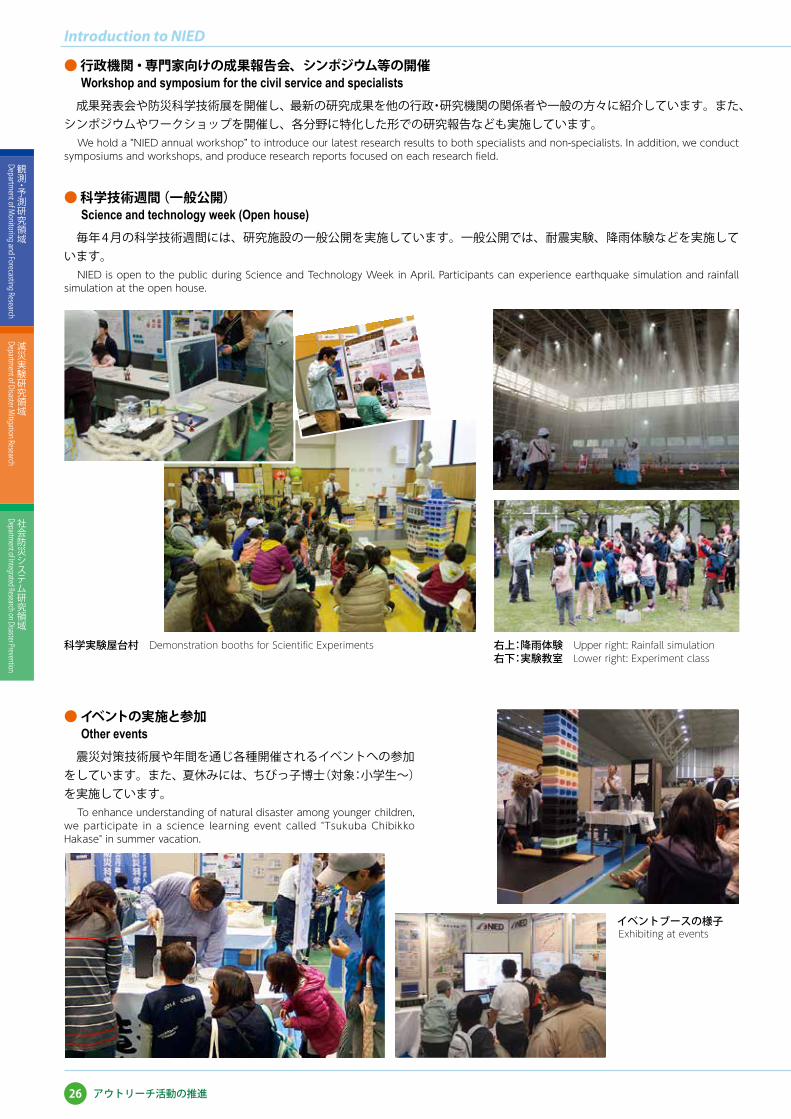
● 行政機関・専門家向けの成果報告会、シンポジウム等の開催Workshop and symposium for the civil service and specialists
● 科学技術週間(一般公開)Science and technology week (Open house)
● イベントの実施と参加Other events
成果発表会や防災科学技術展を開催し、最新の研究成果を他の行政・研究機関の関係者や一般の方々に紹介しています。また、シンポジウムやワークショップを開催し、各分野に特化した形での研究報告なども実施しています。
We hold a “NIED annual workshop” to introduce our latest research results to both specialists and non-specialists. In addition, we conduct symposiums and workshops, and produce research reports focused on each research field.
毎年 4 月の科学技術週間には、研究施設の一般公開を実施しています。一般公開では、耐震実験、降雨体験などを実施しています。
NIED is open to the public during Science and Technology Week in April. Participants can experience earthquake simulation and rainfall simulation at the open house.
科学実験屋台村 Demonstration booths for Scientific Experiments 右上:降雨体験 Upper right: Rainfall simulation右下:実験教室 Lower right: Experiment class
イベントブースの様子 Exhibiting at events
震災対策技術展や年間を通じ各種開催されるイベントへの参加をしています。また、夏休みには、ちびっ子博士(対象:小学生~)を実施しています。
To enhance understanding of natural disaster among younger children, we participate in a science learning event called "Tsukuba Chibikko Hakase" in summer vacation.
26
Introduction to NIED
観測・予測研究領域
Department of M
onitoring and Forecasting Research
減災実験研究領域
Department of Disaster M
itigation Research
社会防災システム研究領域
Department of Integrated Research on Disaster Prevention
アウトリーチ活動の推進
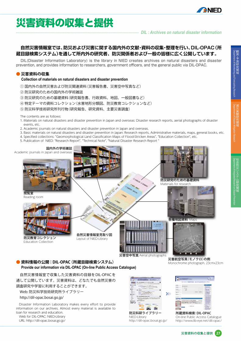
自然災害情報室では、防災および災害に関する国内外の文献・資料の収集・整理を行い、DIL-OPAC(所蔵目録検索システム)を通して所内外の研究者、防災関係者および一般の皆様に広く公開しています。
DIL(Disaster Information Laboratory) is the library in NIED creates archives on natural disasters and disaster prevention, and provides information to researchers, government officers, and the general public via DIL-OPAC.
● 災害資料の収集Collection of materials on natural disasters and disaster prevention
① 国内外の自然災害および防災関連資料(災害報告書、災害空中写真など)② 防災研究のための国内外の学術雑誌③ 防災研究のための基礎資料(研究報告書、行政資料、地図、一般図書など)④ 特定テーマの資料コレクション(水害地形分類図、防災教育コレクションなど)⑤ 防災科学技術研究所刊行物(研究報告、研究資料、主要災害調査)
The contents are as follows:1. Materials on natural disasters and disaster prevention in Japan and overseas: Disaster research reports, aerial photographs of disaster
events, etc.2. Academic journals on natural disasters and disaster prevention in Japan and overseas.3. Basic materials on natural disasters and disaster prevention in Japan: Research reports, Administrative materials, maps, general books, etc.4. Specified collections: “Geomorphological Land Classification Maps of Flood-Stricken Areas”, “Education Collection”, etc.5. Publication of NIED: “Research Report”, “Technical Note”, “Natural Disaster Research Report “
● 資料情報の公開:DIL-OPAC(所蔵目録検索システム)Provide our information via DIL-OPAC (On-line Public Access Catalogue)
自然災害情報室で収集した災害資料の目録を DIL-OPAC を通して公開しています。災害資料は、どなたでも自然災害の調査研究や学習に利用することができます。 Web: 防災科学技術研究所ライブラリー http://dil-opac.bosai.go.jp/ Disaster Information Laboratory makes every effort to provide information on our archives. Almost every material is available to loan for research and education. Web for DIL-OPAC: NIED-Library URL: http://dil-opac.bosai.go.jp/
所蔵資料検索:DIL-OPACOn-line Public Access Cataloguehttp://www.lib-eye.net/dil-opac/
27
観測・予測研究領域
Department of M
onitoring and Forecasting Research
減災実験研究領域
Department of Disaster M
itigation Research
社会防災システム研究領域
Department of Integrated Research on Disaster Prevention
災害資料の収集と提供
災害資料の収集と提供��������������������������������� DIL : Archives on natural disaster information
防災科研ライブラリーNIED-Libraryhttp://dil-opac.bosai.go.jp/
>>>
国内外の学術雑誌Academic journals in Japan and overseas
防災研究のための基礎資料Materials for research
各種地図資料 Maps
災害航空写真(モノクロ)の例Monochrome photograph, 23cmx23cm
災害空中写真 Aerial photographs
自然災害情報室見取り図Layout of NIED-Library防災教育コレクション
Education Collection
閲覧室Reading room
● 文部科学省からの委託研究Entrusted research projects from MEXT
● 文科省・社会システム改革と研究開発の一体的推進等による研究Funds for integrated promotion of social system reform and research and development
2002. 8 - 2007. 3 大都市大震災軽減化特別プロジェクト(通称「大大特」)(「リサーチレボリューション2002」の一環)Special Project for Earthquake Disaster Mitigation in Urban Areas (“Dai-Dai-Toku” Project)
Ⅰ 地震動(強い揺れ)の予測「大都市圏地殻構造調査研究」 Regional Characterization of the Crust in Metropolitan Areas for Prediction of Strong Ground Motion
Ⅱ 耐震性の飛躍的向上「震動台活用による耐震性向上研究」 Significant Improvement of Seismic Performance of Structures
Ⅲ 被害者救助等の災害対応戦略の最適化「災害対応戦略研究」 Advanced Disaster Management System
1.震災総合シミュレーションシステムの開発 Development of the Integrated Earthquake Simulation Systems
2.大都市特性を反映する先端的な災害シミュレーション技術の開発 Development of Frontier Simulation Technologies
Ⅳ 耐震研究の地震防災対策への反映「地震防災統合化研究」 Integration of Earthquake Disaster Mitigation Research Results
2002. 8 - 2007. 3 東アジア域の大気・陸域・海洋水循環変動に伴う災害予測に関する研究 (「人・自然・地球共生プロジェクト ~広域水循環予測及び対策技術の高度化~」の一環)
Prediction of Natural Disasters Caused by Variations in the Atmosphere-Land-Ocean Hydrological Circulation
2003. 4 - 2008. 3 高度即時的地震情報伝達網実用化プロジェクト(「経済活性化のための研究開発プロジェクト」の一環)Project for Realizing and Utilizing Advanced Real-time Earthquake Information
2007. 4 - 2012. 3 首都直下地震防災・減災特別プロジェクト Special Project for Earthquake Disaster Mitigation in the Metropolitan Area
Ⅰ 首都圏周辺でのプレート構造調査、震源断層モデル等の構築等 Characterization of Crust and Earthquake Faults under the Metropolitan Area
Ⅱ 都市施設の耐震性能評価・機能確保に関する研究 Evaluation of Seismic Performance and Capacity of Urban Structures
2008. 3 - 2013. 3 ひずみ集中帯の重点的調査観測・研究Multidisciplinary research project for high strain rate zone
2010. 4 -(2015. 3) 高解像度気候変動シナリオを用いた大都市圏の風水害脆弱性評価に基づく適応に関する研究Vulnerability and Adaptation to Climate Change in Water Hazard assessed using Regional Climate Scenarios in the Tokyo Region
2012. 4 - 2013. 3 長周期地震動予測地図作成等支援事業Long period strong-motion hazard mapping project
2013. 4 -(2015. 3) 長周期地震動ハザードマップ作成等支援事業Long period strong-motion hazard mapping project
2013. 4 -(2018. 3) 統合化地域防災実践支援 Webサービスの構築Establishment of Integrated Web Service for Assisting Local Disaster Management Practices
2013. 4 -(2018. 3) 北海道中標津町を対象とした吹雪発生予測システム活用と効果的な雪氷防災対策への支援Effective Utilization of a Blowing Snow Prediction System for Enhancement of Snow and Ice Disaster Mitigation in Nakashibetsu, Hokkaido
1999. 7 - 2004. 3 アジア・太平洋地域に適した地震・津波災害軽減技術の開発とその体系化に関する研究Development of Earthquake and Tsunami Disaster Mitigation Technologies and Their Integration for the Asia-Pacific Region (EqTAP)
2004. 7 - 2007. 3 危機管理対応情報共有技術による減災対策Disaster Mitigation Using the Crisis-Adaptive Information Sharing Platform and Technologies
2004.11 - 2005. 3 2004 年新潟県中越地震に関する緊急調査研究Urgent Investigation and Research for the 2004 Niigata-ken Chuetsu Earthquake
2005. 7 - 2006. 3 防災科学技術の国際連携への提言International Collaboration in Science and Technologies for Disaster Reduction
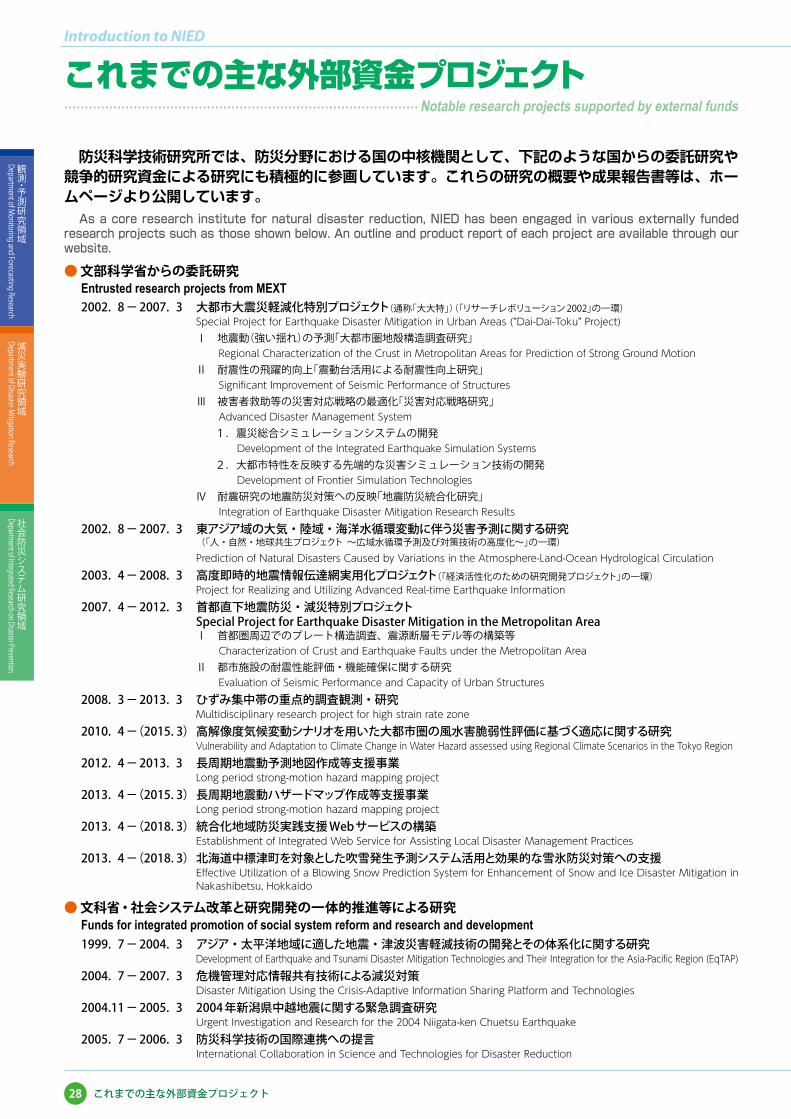
防災科学技術研究所では、防災分野における国の中核機関として、下記のような国からの委託研究や競争的研究資金による研究にも積極的に参画しています。これらの研究の概要や成果報告書等は、ホームページより公開しています。
As a core research institute for natural disaster reduction, NIED has been engaged in various externally funded research projects such as those shown below. An outline and product report of each project are available through our website.
28
Introduction to NIED
観測・予測研究領域
Department of M
onitoring and Forecasting Research
減災実験研究領域
Department of Disaster M
itigation Research
社会防災システム研究領域
Department of Integrated Research on Disaster Prevention
これまでの主な外部資金プロジェクト
これまでの主な外部資金プロジェクト����������������������������� Notable research projects supported by external funds
2006. 2 - 2006. 3 2005-06 冬期豪雪による雪害対策に関する緊急調査研究Urgent Investigation and Research for the 2005-06 Heavy Snowfall
2006. 7 - 2009. 3 アジア防災科学技術情報基盤の形成(DRH-Asia)Disaster Reduction Hyperbase – Asian Application
2006. 7 - 2011. 3 統合化地下構造データベースの構築 Development of Integrated Geophysical and Geological Information Database
2007. 5 - 2008. 3 2007 年能登半島地震に関する緊急調査研究Urgent Investigation and Research for the 2007 Noto Hanto Earthquake
2007. 8 - 2008. 3 2007 年新潟県中越沖地震に関する緊急調査研究Urgent Investigation and Research for the 2007 Niigata Chuetsu-Oki Earthquake
2009. 6 - 2014. 3 フィリピン地震火山監視強化と防災情報の利活用推進(地球規模課題対応国際科学技術協力事業)Enhancement of Earthquake and Volcano Monitoring and Effective Utilization of Disaster Mitigation Information in the Philippines (Science and Technology Research Partnership for Sustainable Development)
2010. 2 -(2015. 2) フィリピン地震火山監視強化と防災情報の利活用推進プロジェクト(地球規模課題対応国際科学技術協力事業)Enhancement of Earthquake and Volcano Monitoring and Effective Utilization of Disaster Mitigation Information in the Philippines Project (Science and Technology Research Partnership for Sustainable Development)
2010. 7 -(2015. 3) 気候変動に伴う極端気象に強い都市創りTokyo Metropolitan Area Convection Study for Extreme Weather Resilient Cities(TOMACS)
2010.12 - 2014. 3 次世代地震ハザードマップ作成のためのハザード評価手法の高度化に関する研究(戦略的国際科学技術協力推進事業(研究交流型))
A methodological study of Seismic Hazard Assessment for the Next Generation Map(A strategic international research cooperative program )
2011. 4 - 2014. 3 官民協働危機管理クラウドシステムCrisis management information systems in cloud with public and private cooperation
2011. 4 - 2013.11 カメルーン火口湖ガス災害防止の総合対策と人材育成(地球規模課題対応国際科学技術協力事業)Magmatic Fluid Supply into Lakes Nyos and Monoun, and Mitigation of Natural Disasters in Cameroon (Science and Technology Research Partnership for Sustainable Development)
2011. 8 -(2016. 3) マレーシアにおける地すべり災害および水害による被災低減に関する研究(地球規模課題対応国際科学技術協力事業)Research and Development for Reducing Geo-Hazard Damage in Malaysia caused by Landslide & Flood (Science and Technology Research Partnership for Sustainable Development)
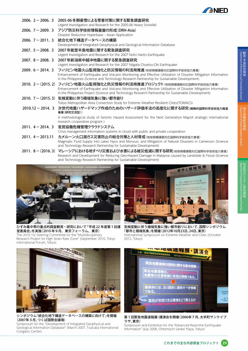
気候変動に伴う極端気象に強い都市創りにおいて、国際シンポジウム「都市と極端気象」を開催(2012年10月23日、24日、東京)International Symposium on Extreme Weather and Cities (October 2012, Tokyo)
第1回緊急地震速報展・講演会を開催(2006年7月、大手町サンケイプラザ、東京)Symposium and Exhibition for the “Advanced Real-time Earthquake Information” (July 2006, Ohtemachi Sankei Plaza, Tokyo)
シンポジウム「統合化地下構造データベースの構築に向けて」を開催(2007年3月、つくば国際会議場)Symposium for the “Development of Integrated Geophysical and Geological Information Database” (March 2007, Tsukuba International Congress Center)
ひずみ集中帯の重点的調査観測・研究において「平成 22 年度第1回運営委員会」を実施(2010 年9月、東京フォーラム、東京)The 2010 1st Steering Committee for the “Multidisciplinary Research Project for High Strain Rate Zone” (September 2010, Tokyo International Forum, Tokyo)
29
観測・予測研究領域
Department of M
onitoring and Forecasting Research
減災実験研究領域
Department of Disaster M
itigation Research
社会防災システム研究領域
Department of Integrated Research on Disaster Prevention
これまでの主な外部資金プロジェクト
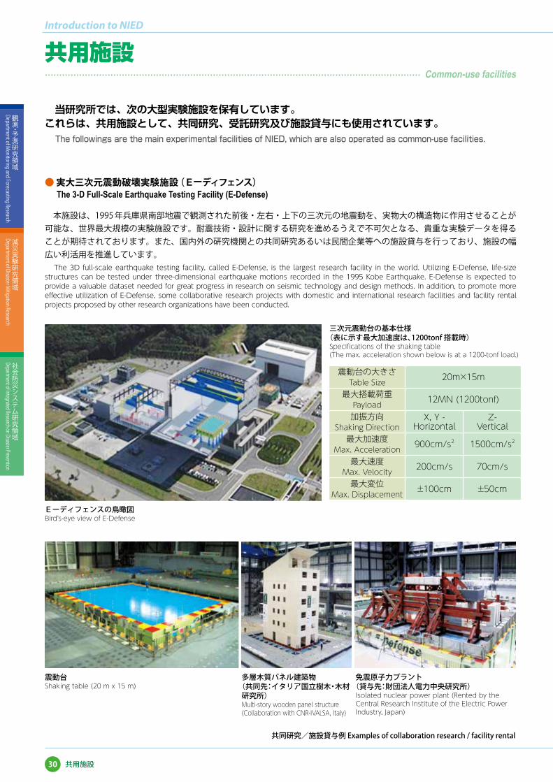
三次元震動台の基本仕様(表に示す最大加速度は、1200tonf 搭載時)Specifications of the shaking table (The max. acceleration shown below is at a 1200-tonf load.)
震動台Shaking table (20 m x 15 m)
多層木質パネル建築物(共同先:イタリア国立樹木・ 木材
研究所)Multi-story wooden panel structure (Collaboration with CNR-IVALSA, Italy)
免震原子力プラント(貸与先:財団法人電力中央研究所)Isolated nuclear power plant (Rented by the Central Research Institute of the Electric Power Industry, Japan)
当研究所では、次の大型実験施設を保有しています。これらは、共用施設として、共同研究、受託研究及び施設貸与にも使用されています。
The followings are the main experimental facilities of NIED, which are also operated as common-use facilities.
本施設は、1995 年兵庫県南部地震で観測された前後・左右・上下の三次元の地震動を、実物大の構造物に作用させることが可能な、世界最大規模の実験施設です。耐震技術・設計に関する研究を進めるうえで不可欠となる、貴重な実験データを得ることが期待されております。また、国内外の研究機関との共同研究あるいは民間企業等への施設貸与を行っており、施設の幅広い利活用を推進しています。
The 3D full-scale earthquake testing facility, called E-Defense, is the largest research facility in the world. Utilizing E-Defense, life-size structures can be tested under three-dimensional earthquake motions recorded in the 1995 Kobe Earthquake. E-Defense is expected to provide a valuable dataset needed for great progress in research on seismic technology and design methods. In addition, to promote more effective utilization of E-Defense, some collaborative research projects with domestic and international research facilities and facility rental projects proposed by other research organizations have been conducted.
震動台の大きさTable Size
20m×15m
最大搭載荷重Payload
12MN (1200tonf)
加振方向Shaking Direction
X, Y -Horizontal
Z-Vertical
最大加速度Max. Acceleration
900cm/s2 1500cm/s2
最大速度Max. Velocity
200cm/s 70cm/s
最大変位Max. Displacement
±100cm ±50cm
● 実大三次元震動破壊実験施設(Eーディフェンス)The 3-D Full-Scale Earthquake Testing Facility (E-Defense)
Eーディフェンスの鳥瞰図Bird’s-eye view of E-Defense
30
Introduction to NIED
観測・予測研究領域
Department of M
onitoring and Forecasting Research
減災実験研究領域
Department of Disaster M
itigation Research
社会防災システム研究領域
Department of Integrated Research on Disaster Prevention
共用施設
共用施設�������������������������������������������� Common-use facilities
共同研究/施設貸与例 Examples of collaboration research / facility rental

● 大型耐震実験施設Large-scale Earthquake Simulator
● 大型降雨実験施設Large-scale Rainfall Simulator
● 雪氷防災実験棟Cryospheric Environment Simulator
世界最大の規模・能力を有する散水装置で、毎時 15~300mm の雨を降らせることができます。この施設を使って、山崩れ、土石流、土壌侵食の解明などの研究を行っています。
This facility has the world's largest rainfall area and sprinkler capacity, and can produce rainfall intensities between 15 and 300 mm/hr. The facility is used to conduct research into landslides, debris flow, soil erosion, etc.
天然に近い結晶形の雪を降らせる装置や風洞装置などを備えた大型低温室において、雪氷に関する基礎研究や、雪氷災害の発生機構とその対策に関する研究を行っています。
Basic and applied studies related to snow disasters as well as snow science are conducted using a large cold room with a snowfall machine, wind tunnel, and so on.
五重塔の振動実験 (1/5スケール)Shaking test of a five-story pagoda (scale: 1/5)
大型降雨実験施設全景Full view of the Large-scale Rainfall simulator
雪氷防災実験棟全景Overall view of the Cryospheric Environment Simulator
鉄道信号機の着雪対策に関する実験Experiment of countermeasures against snow accretion on railway signals
建物周囲の雪の吹き溜まり形成に関する風洞実験Wind-tunnel experiment on the formation of snowdrifts around buildings
大規模な模型斜面に散水して、山崩れ現象を再現(実験中)Reproducing a landslide by sprinkling water on a large model slope (during experiment)
崩壊した斜面(実験後)Collapsed model slope (after experiment)
鉄筋コンクリート建物の振動破壊実験(1/3スケール)Shaking test of a reinforced concrete building (scale: 1/3)
1970 年に筑波研究学園都市施設第 1 号として開設されました。サイズ 14.5m×15m の大型テーブルを利用して、大規模な耐震実験を実施することができます。現在でも、テーブルサイズはE-ディフェンスについで世界第 2 位の大きさです。
This facility was established in 1970, as the first research facility in Tsukuba Science City. The size of the shaking table is 14.5 m × 15 m, and it is the second-largest scale in the world. This facility enables large-scale earthquake-proof experiments.
31
観測・予測研究領域
Department of M
onitoring and Forecasting Research
減災実験研究領域
Department of Disaster M
itigation Research
社会防災システム研究領域
Department of Integrated Research on Disaster Prevention
共用施設
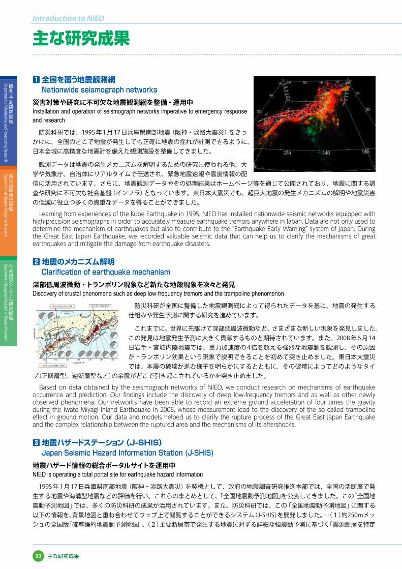
1 全国を覆う地震観測網Nationwide seismograph networks
災害対策や研究に不可欠な地震観測網を整備・運用中 Installation and operation of seismograph networks imperative to emergency response and research
防災科研では、1995 年 1 月 17 日兵庫県南部地震(阪神・淡路大震災)をきっかけに、全国のどこで地震が発生しても正確に地震の揺れが計測できるように、日本全域に高精度な地震計を備えた観測施設を整備してきました。
観測データは地震の発生メカニズムを解明するための研究に使われる他、大学や気象庁、自治体にリアルタイムで伝送され、緊急地震速報や震度情報の配信に活用されています。さらに、地震観測データやその処理結果はホームページ等を通じて公開されており、地震に関する調査や研究に不可欠な社会基盤(インフラ)となっています。東日本大震災でも、超巨大地震の発生メカニズムの解明や地震災害の低減に役立つ多くの貴重なデータを得ることができました。
Learning from experiences of the Kobe Earthquake in 1995, NIED has installed nationwide seismic networks equipped with high-precision seismographs in order to accurately measure earthquake tremors anywhere in Japan. Data are not only used to determine the mechanism of earthquakes but also to contribute to the “Earthquake Early Warning” system of Japan. During the Great East Japan Earthquake, we recorded valuable seismic data that can help us to clarify the mechanisms of great earthquakes and mitigate the damage from earthquake disasters.
2 地震のメカニズム解明Clarification of earthquake mechanism
深部低周波微動・トランポリン現象など新たな地殻現象を次々と発見 Discovery of crustal phenomena such as deep low-frequency tremors and the trampoline phenomenon
防災科研が全国に整備した地震観測網によって得られたデータを基に、地震の発生する仕組みや発生予測に関する研究を進めています。
これまでに、世界に先駆けて深部低周波微動など、さまざまな新しい現象を発見しました。この発見は地震発生予測に大きく貢献するものと期待されています。また、2008 年 6 月 14日岩手・宮城内陸地震では、重力加速度の 4 倍を超える強烈な地震動を観測し、その原因がトランポリン効果という現象で説明できることを初めて突き止めました。東日本大震災では、本震の破壊が進む様子を明らかにするとともに、その破壊によってどのようなタイ
プ(正断層型、逆断層型など)の余震がどこで引き起こされているかを突き止めました。
Based on data obtained by the seismograph networks of NIED, we conduct research on mechanisms of earthquake occurrence and prediction. Our findings include the discovery of deep low-frequency tremors and as well as other newly observed phenomena. Our networks have been able to record an extreme ground acceleration of four times the gravity during the Iwate Miyagi Inland Earthquake in 2008, whose measurement lead to the discovery of the so called trampoline effect in ground motion. Our data and models helped us to clarify the rupture process of the Great East Japan Earthquake and the complex relationship between the ruptured area and the mechanisms of its aftershocks.
3 地震ハザードステーション(J-SHIS)Japan Seismic Hazard Information Station (J-SHIS)
地震ハザード情報の総合ポータルサイトを運用中 NIED is operating a total portal site for earthquake hazard information
1995 年 1 月 17 日兵庫県南部地震(阪神・淡路大震災)を契機として、政府の地震調査研究推進本部では、全国の活断層で発生する地震や海溝型地震などの評価を行い、これらのまとめとして、「全国地震動予測地図」を公表してきました。この「全国地震動予測地図」では、多くの防災科研の成果が活用されています。また、防災科研では、この「全国地震動予測地図」に関する以下の情報を、背景地図と重ね合わせてウェブ上で閲覧することができるシステム(J-SHIS)を開発しました。…(1)約250mメッシュの全国版「確率論的地震動予測地図」、(2)主要断層帯で発生する地震に対する詳細な強震動予測に基づく「震源断層を特定
32
Introduction to NIED
観測・予測研究領域
Department of M
onitoring and Forecasting Research
減災実験研究領域
Department of Disaster M
itigation Research
社会防災システム研究領域
Department of Integrated Research on Disaster Prevention
�������������������������������������������������������������������������������������������������������� Major research results of NIED
主な研究成果
主な研究成果
した地震動予測地図(想定地震地図)」、(3)以上の計算に用いた表層地盤増幅率や深部地盤モデル等
J-SHIS は、地震ハザード情報の総合ポータルサイトとも言えるものであり、防災訓練や地域の防災計画の検討など、さまざまなシーンで利用されています。なお、これまで J-SHIS では津波に関する情報は扱っていませんでしたが、津波ハザードも加えた総合ポータルサイトを構築することは今後の重要な課題です。
Considering the effect of the Kobe Earthquake, the headquarters of Earthquake Research Promotion announced the “National Seismic Hazard Maps of Japan” based on evaluation of earthquakes occurring at active faults and plate boundaries. NIED has created a website called the “Japan Seismic Hazard Information Station,” known as J-SHIS. J-SHIS includes a 250-m-mesh probabilistic seismic hazard map, seismic hazard maps targeting certain hypocenter faults, as well as site amplification factors and subsurface structure data used to elaborate the map.
J-SHIS is a total portal site of earthquake hazard information and we are pursuing the construction of a new version that includes tsunami hazard information as well.
4 緊急地震速報への貢献
Contribution to the “Earthquake Early Warning” system画期的な即時震源決定手法で緊急地震速報の実用化に大きく貢献An epoch-making real-time hypocenter determination technique contributed largely to realization of the “Earthquake Early Warning” system
防災科研は、「着未着法」という地震の震源を地震観測データから直ちに検出する画期的な手法を開発しました。この成果は、気象庁と共同で開発した緊急地震速報システムにも活用されています。緊急地震速報は、2007 年 10 月 1 日から提供が開始され、大きな揺れが到達する前に地震の発生を知らせることによって、さまざまな防災対応をとることが可能になりました。なお、緊急地震速報には、防災科研の高感度地震観測網 Hi-net(約 800 点)のデータも利用されています。
東日本大震災やその後の余震でも、気象庁から多くの緊急地震速報が発報されましたが、その精度向上や巨大地震への対応は今後の課題として残されており、防災科研でも継続して研究を続けていきます。
NIED has developed an epoch-making technique that detects the hypocenter of an earthquake immediately from observed data. This technique is applied to the “Earthquake Early Warning” system co-developed by JMA and NIED. In addition, the high-sensitivity seismograph network (Hi-net) is utilized for its system. Our goal is to enhance its precision in order to be well prepared for forthcoming mega earthquakes. 5 実大三次元震動破壊実験施設(Eーディフェンス)
Three-Dimensional Full-Scale Earthquake Testing Facility(E-Defense)実物大の構造物の破壊実験で地震防災に大きく貢献する成果を次々と創出 Producing remarkable outcomes that contribute to the earthquake disaster mitigation by conducting experiments on full-scale structures
1995 年 1 月 17 日兵庫県南部地震(阪神・淡路大震災)を契機として、防災科研は各種の建築・土木構造物の耐震設計法や耐震補強工法の妥当性の検証を、
「小さな模型でなく実物大の大きさで」「実際の地震と同じ三次元方向の揺れで」「破壊に至るまで」行うことを目的に、E-ディフェンスを計画・整備してきました。
2005 年の完成後、E-ディフェンスでは各種の実験が実施され、木造建物、鉄筋コンクリート構造物、鉄骨建物、地盤基礎構造などの破壊データの取得、耐震補強効果の検証、学会指針改定や解析技術の高度化へのデータ提供、耐震改修促進への貢献、防災教育に関する資料提供等、多くの成果を上げています。東日本大震災では、継続時間の非常に長い地震波が観測されました。そのよう
33
観測・予測研究領域
Department of M
onitoring and Forecasting Research
減災実験研究領域
Department of Disaster M
itigation Research
社会防災システム研究領域
Department of Integrated Research on Disaster Prevention
�������������������������������������������������������������������������������������������������������� Major research results of NIED
主な研究成果

な継続時間の長さが構造物に与える影響の解明も、今後の課題として取り組んでいく必要があると考えています。
With the Kobe Earthquake as a turning point, NIED has constructed E-Defense aiming to verify earthquake-resistant design methods and reinforcement methods for building structures by testing full-scale structures with three-dimensional motions until their collapse. After the completion of E-Defense, various experiments on wooden buildings, reinforced concrete buildings, steel-frame buildings, and foundation structures have been conducted and we were able to obtain their collapse data, verify earthquake-resistant countermeasures, contribute to promotion of earthquake-resistant repair, and also provide documents for education. We think it is essential to clarify the influence of long-term motions of buildings that were observed during the Great East Japan Earthquake. 6 Xバンド・マルチパラメータレーダ
X Band Multi-Parameter Radarゲリラ豪雨を迎え撃つ新兵器が実用化段階に New apparatus against torrential rainfall is in the practical stage
高度に発達した交通網や通信網を有し、数百万の人が生活する大都市は、局地的な豪雨(いわゆる「ゲリラ豪雨」)に対して脆弱といえます。アスファルト舗装の道路や密集したコンクリート建物のために、局地的な豪雨が降ると雨水が一気に下水道へ流れ込みます。排水処理機能がこれに追いつかない場合には雨水が下水道からあふれ出し、道路や鉄道の冠水、繁華街や地下街での浸水による被害が発生します。
防災科研では、このような局地的な豪雨の監視と予測技術を確立するために、X バンド MPレーダを用いた研究開発を行ってきました。2008 年 8 月に東京都豊島区雑司が谷で豪雨災害が生じた際、MPレーダによって、従来レーダでは困難だった局地的な豪雨を捉えることに成功しました。現在、この成果を活用して、国土交通省水管理・国土保全局により、MPレーダネットワークが全国の主要都市圏等に合計 38 基配備、運用されています。
Metropolitan areas where there are highly developed transportation and communication networks are vulnerable to localized torrential rainfall. Because of their asphalt pavements and dense concrete buildings, rainfall will stream directly into sewers, making the drains overflow and leading to inundation of roads, railroads, downtown areas, and underground facilities. NIED has conducted research and development in order to monitor and establish forecast technology for localized torrential rainfall using an X Band Multi-Parameter Radar. Making use of its outcome, 38 MP radars have been installed and operated in urban areas by the Ministry of Land, Infrastructure, Transport and Tourism. 7 雪氷災害発生予測システム
Snow disaster forecasting system安全で快適な雪国の生活を支援する予測システムを試験運用中 The snow disaster forecasting system, which supports safe and comfortable life in snowy areas, is under experimental use
防災科研では、雪崩、地吹雪、道路の雪氷状態などを予測する「雪氷災害発生予測システム」を開発しており、2006 年冬より、雪国の国、県、市の機関などと連携して、予測システムの改良のための試験運用を始めています。
2010 年の冬に吹雪による大規模な交通障害が発生した新潟市では、吹雪時の視程予測情報を道路管理に利用しています。我が国の自然災害による犠牲者のうち雪氷災害によるものは、大規模地震を除くと風水害によるものに匹敵します(防災白書 2010 年版)。また、戦後 2 番目の被害をもたらした「平成 18 年豪雪」では、交通事故死者も含めると雪による犠牲者は 276 名にものぼりました(防災科研調査)。このような災害を防止するため、防災科研では雪氷災害
発生予測手法の高精度化に取り組んでいます。
NIED has developed a snow disaster forecasting system to predict snow avalanche, blowing snow, and road snow condition. Since 2006, the forecasting system has been used experimentally for its validation and improvement in cooperation with public organizations in snowy prefectures and cities. Niigata City, where a large traffic jam took place owing to blowing snow in the winter of 2010, applies forecast of low visibility due to blowing snow to road traffic management. In Japan, the
34
Introduction to NIED
観測・予測研究領域
Department of M
onitoring and Forecasting Research
減災実験研究領域
Department of Disaster M
itigation Research
社会防災システム研究領域
Department of Integrated Research on Disaster Prevention
主な研究成果
�������������������������������������������������������������������������������������������������������� Major research results of NIED主な研究成果

number of fatalities due to snow and ice disasters ranks with that due to storm and flood disasters except in the years with huge earthquakes. In the winter of 2006, fatalities caused by snow including traffic accidents on snowy roads reached 276, which is the second-worst record of snow disaster in the past 65 years. NIED is undertaking research to improve the accuracy and availability of snow disaster forecasting for mitigation. 8 e コミュニティ・プラットフォーム
e-community platform地域社会を支援する参加型のコミュニティ情報基盤 Web システム Community-involved information-based web system that supports local society
これからの地域社会は、さまざまな団体やグループが協働して、地域を自治または経営していくことが求められます。そのためには、さまざまな団体やグループが持つ情報や技術などを活用しながら、地域の諸問題を解決するためのコミュニケーションが必要不可欠です。災害時の対応の検討や日頃の防災活動においてもコミュニケーションが欠かせません。防災科研では、これらを支えるインターネット上の情報基盤として「e コミュニティ・プラットフォーム」(通称eコミ)を開発しています。
e コミは、グループウェアと地図(e コミマップ)で構成されており、東日本大震災の復旧・復興支援にも貢献しています。また地域社会のコミュニティ情報基盤としてはもちろん、自治体向けの災害対応システム基盤としても活用ができます。
In future local society, it is definitely required for parties or groups to cooperate with each other and to manage regions by themselves. To realize this goal, it is essential to utilize useful information and skills possessed by groups of people to communicate in order to solve various issues in their regions.
Communication is the key to disaster management and daily disaster prevention activities. NIED has developed the “e-community platform,” e-comi for short, as a supportive information-based web system. It consists of groupware and an e-comi map, which also contributes to recovery and the renovation of areas damaged by the Great East Japan Earthquake. Moreover, e-comi can be utilized as disaster response system infrastructures for local governments as well as an information-based platform for local societies.
9 火山活動の観測と予測研究Observation and forecast research for volcanic activity
2011 年霧島山(新燃岳)噴火におけるマグマの蓄積位置や噴出量を把握Estimating magma accumulation points and erupted magma volume during the 2011 Kirishima-yama (Shinmoe-dake) eruption
防災科研では、火山活動の観測と予測研究のために、GPS や傾斜計、高感度および広帯域地震計等を備えた観測施設を 10 カ所の活火山において整備してきました。さらに、リモートセンシングを用いた広域地殻変動の検出や熱・ガス分布の測定、数値シミュレーションによる噴火発生機構の解明等を実施してきました。
2011 年霧島山(新燃岳)の噴火では、これらの観測データを用いて、マグマの蓄積位置や噴出量を把握することができました。また、緊急調査研究として、噴火推移や噴火現象の観測研究、火山灰等の拡散予測研究を実施しました。得られた結果は、火山噴火予知連絡会において、新燃岳の火山活動評価に活用されました。今後は、国内外の火山における活動把握に参考となる知見を得ることを目指して、研究を進めていきます。
NIED has established volcanic observation sites with GPS, tiltmeters, and high-sensitivity and broadband seismographs in order to measure the magmatic phenomena of 10 volcanoes. We have also used remote sensing to detect broader crustal deformation and measured volcanic heat and gas distribution, and we have also simulated the eruption mechanism. In the 2011 eruption of Kirishima-yama (Shinmoe-dake), we were able to detect the accumulation point and estimate the volume of erupted magma. As part of an urgent investigation, we conducted research on monitoring eruptions and their phenomena and on predicting volcanic ash diffusion. The result was utilized to evaluate the volcanic activity of Kirishima-yama (Shinmoe-dake) at the Coordinating Committee for the Prediction of Volcanic Eruptions. We seek to acquire new knowledge that can be used to evaluate volcanic activity inside and outside Japan.
35
観測・予測研究領域
Department of M
onitoring and Forecasting Research
減災実験研究領域
Department of Disaster M
itigation Research
社会防災システム研究領域
Department of Integrated Research on Disaster Prevention
主な研究成果
�������������������������������������������������������������������������������������������������������� Major research results of NIED
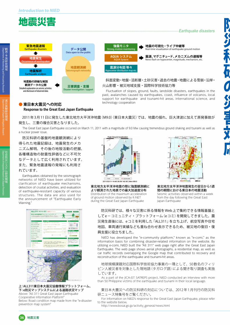
緊急地震速報Earthquake disasters データ公開
Data open to the public
地震観測網Seismograph networks
災害調査・支援Disaster investigation / support
地震発生Occurrence of earthquakes
地震解析Earthquake analysis
地震動の詳細な解説観測データの公開
Detailed explanation on seismic activities and disclosure of observed data
強震モニタStrong-motion monitoring
地震の可視化・ライブ中継等Real-time visualization of earthquake ground motion
震源、マグニチュード、メカニズムの速報等News flash on hypocenter, magnitude, mechanism, etc.
震源分布図 等々Hypocenter distribution map etc.
AQUA システムAQUA System
斜面変動・地盤・活断層・土砂災害・過去の地震・地震による雪崩・沿岸・火山影響・被災地域支援・国際科学技術協力等
Fluctuation of slopes, ground, faults, landslide disasters, earthquakes in the past, avalanches caused by earthquakes, coast, influence of volcanos, local support for earthquake and tsunami-hit areas, international science, and technology cooperation
東日本大震災への防災科研の対応については、2012 年 1 月刊行の防災科研ニュース特集号をご覧ください。
For information on NIED’s response to the Great East Japan Earthquake, please refer to the website below.
http://www.bosai.go.jp/activity_general/news.html
上:ALL311東日本大震災協働情報プラットフォーム、下:e防災マップシステムによる道路状況マップ Above: “All 311 Great East Japan Earthquake Cooperative Information Platform” Below: Road condition map made from the “e-disaster prevention map system”
地球規模課題対応国際科学技術協力事業の一環として、50 数名のフィリピン人被災者を対象とした現地語(タガログ語)による聞き取り調査も実施しています。
As a part of the JICA-JST SATREPS project, NIED conducted an interview with more than 50 Philippine victims of the earthquake and tsunami in their local language.
防災科研では、様々な災害に係る情報を Web 上で集約できる情報基盤として e- コミュニティ・プラットフォーム(e コミ)を開発してきました。震災発生直後には、e コミを利用した「ALL311」を立ち上げ、航空写真や住宅地図、車両通行実績なども重ね合わせ表示できるため、被災地の復旧・復興支援に役立ちました。
NIED has developed the “e-community platform,” known as “e-comi,” as the information basis for combining disaster-related information on the website. By utilizing e-comi, NIED built the “All 311” web page right after the Great East Japan Earthquake. The web page shows aerial photographs, a residential map, as well as car traffic records overlapping the Google map that contributed to recovery and reconstruction of the earthquake and tsunami-hit areas.
東北地方太平洋沖地震発生の翌日から1週間の期間における東日本の地震活動Seismic activities observed within a week from the day following the Great East Japan Earthquake
東北地方太平洋沖地震の際に強震観測網により観測された地表での最大加速度分布Distribution of the maximum acceleration of ground motion observed by K-NET during the Great East Japan Earthquake
防災科研の基盤的地震観測網により得られた地震記録は、地震発生のメカニズム解明、その後の地殻活動の把握、各種構造物の耐震性評価などに不可欠なデータとして広く利用されています。また、緊急地震速報の発報にも利用されています。
Earthquakes obtained by the seismograph networks of NIED have been utilized for clarification of earthquake mechanisms, detection of crustal activities, and evaluation of earthquake-resistant capacity of various structures. The data are also used for the announcement of “Earthquake Early Warning.”
2011 年 3 月 11 日に発生した東北地方大平洋沖地震(M9.0)(東日本大震災)では、地震の揺れ、巨大津波に加えて原発事故が発生し、三重の複合災害となりました。
The Great East Japan Earthquake occurred on March 11, 2011 with a magnitude of 9.0 Mw causing tremendous ground shaking and tsunami as well as a nuclear power issue.
● 東日本大震災への対応Response to the Great East Japan Earthquake
防災科研の災害対応
36
Introduction to NIED
観測・予測研究領域
Department of M
onitoring and Forecasting Research
減災実験研究領域
Department of Disaster M
itigation Research
社会防災システム研究領域
Department of Integrated Research on Disaster Prevention
地震災害���������������������������������������������Earthquake disasters
地震災害

災害調査Disaster investigation
国土交通省 X バンド MPレーダ雨量情報Precipitation information using
MLIT X-Band Multi-Parameter Radar情報公開(情報提供)
Information disclosure
監視システムへの貢献Contribution to the warning system
気象・土砂災害発生Occurrence of meteorological and landslide disasters
X-NET の運用Operation of X-NET
解析Analysis
現地調査・聞き取り調査等Field work and hearing investigation
山 地 積 雪気象観測網
Snow and WeatherObservation Network
データ公開Data open to the public
雪崩等の災害発生Occurrence of snow disasters
国、自治体への災害予測情報提供の試験運用
Experimental use withpublic organizations
雪氷災害発生予測システム
Snow DisasterForecasting System
現地調査Field investigation
発生要因の解明と安全対策の助言等Clarification of the cause and
advice on safety measures, etc.
データ公開Providing observation data
on the website
火山観測網Volcano Observation
Network
V-net
火山噴火Volcanic eruption
監視・観測Monitoring and observation
災害調査Disaster investigation
ポータルサイトPortal site
火山噴火予知連絡会Coordinating Committee for
Prediction of Volcanic Eruptions
大学・観測研究の支援
Support for researches of universities
防災科研では、雪氷災害発生予測システムを開発し、積雪地域の国、県、市の機関などと連携して試験運用を行っています。また、雪氷災害の防止に向けて、山地積雪観測網を活用し情報公開を行っています。さらに、平成 26 年(2014 年)に関東甲信地方で発生した大雪の場合のように、災害発生時には専門家派遣要請に対応し、雪崩等の危険性判定と対策などを提言しています。
NIED has developed a snow disaster forecasting system, which has been used experimentally in cooperation with public organizations in snowy areas. NIED also operates the Snow and Weather Observation Network and provides data on the website to prevent snow disasters. Once a snow disaster occurs, such as the case of the snow damages in the winter of 2014, NIED supports risk evaluation following disasters and gives advice on safety measures.
広い範囲で記録的な大雨になった台風 12 号により、死者・行方不明者、住家被害等々甚大な災害がもたらされました。この災害に対し防災科研では、MPレーダ等による解析をはじめ、現地調査等を行っています。
Typhoon Talas, which caused torrential rainfall in a wide area, turned into tremendous disaster with many people killed or missing, as well as great damage to residences. Considering the influence of this disaster, NIED has analyzed the data of MP radars and conducted field investigation.
火山噴火災害の軽減に資するため、次のような対応を行いました。①火山活動連続観測網(VIVA ver.2)による観測データの公開②平成 23 年霧島山新燃岳噴火に関する緊急調査研究の実施③霧島山(新燃岳)情報ポータルサイトの開設
In order to reduce volcanic eruption hazards, NIED 1) provided observation data on the website VIVA2, 2) conducted urgent research on the 2011 Shinmoe-dake eruption, and 3) established a portal site on the web.
2011 年 1 月に始まった霧島山(新燃岳)噴火は、火山灰の放出・拡散による航空機の欠航や農作物への被害、空振による建物被害などのさまざまな災害をもたらしました。
The eruption of Kirishima-yama Shinmoe-dake, which began in January 2011, caused various problems such as flight cancellations and crop damage by dispersion of volcanic ash, as well as damage to buildings by infrasonic waves.
● 霧島山(新燃岳) Kirishima-yama Shinmoe-dake
● 2011 年台風 12 号 2011 Typhoon Talas
降雪・積雪データの公開Website showing snowfall and snow cover data
火山噴火予知研究のデータベースDatabase for volcanic eruption prediction studies
台風12号のWebサイトWebsite for Typhoon Talas
新燃岳噴火時の観測データ公開のWebサイトWebsite for observation data during the Shinmoe-dake eruption
平成26年の関東甲信地方の大雪災害における対策の助言Advising on counter measures at the disasters due to heavy snowfall in the 2014 winter
防災科研の災害対応
37
観測・予測研究領域
Department of M
onitoring and Forecasting Research
減災実験研究領域
Department of Disaster M
itigation Research
社会防災システム研究領域
Department of Integrated Research on Disaster Prevention
火山災害
雪氷災害
気象・土砂災害
���������������������������������������������� Volcanic disasters
��������������������������������������������Snow and ice disasters
������������������������������������ Meteorological and landslide disasters
火山災害 気象・土砂災害 雪氷災害
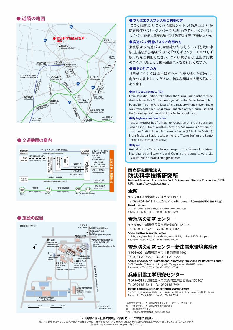
● 筑波大学 University of Tsukuba
● 防災科学技術研究所 NIED
つくば駅Tsukuba Sta.
土浦駅Tsuchiura Sta.
荒川沖駅Arakawaoki Sta.
ひたち野うしく駅Hitachinoushiku Sta.
至上野to Ueno
至水戸to Mito
研究学園駅Kenkyū-gakuen Sta.
万博記念公園駅Bampaku-kinenkōen Sta.
みどりの駅Midorino Sta.
みらい平駅 Miraidaira Sta.
谷田部I.C. Yatabe I.C.
つくば牛久I.C. Tsukuba-Ushiku I.C.
牛久阿見I.C.Ushiku-Ami I.C.
つくば中央I.C. Tsukuba-chuo I.C.
桜土浦 I.C.Sakuratsuchiura I.C.
土浦北 I.C.Tsuchiurakita I.C.
つくばJCT Tsukuba JCT
408
408
354
6
125
常磐自動車道
JOBAN EXPRESSWAY
圏央
道
KEN-O EXPRESSWAY
Tsukuba Express
つくばエクスプレス
Science-Odori
サイエンス大通り
Nishi-Odori
西大通り
Higashi-Odori
東大通り
● つくばセンター Tsukuba Center
Ushiku - Gakuen sen
牛久学園線
JR Joban Line
JR常磐線 国立研究開発法人
防災科学技術研究所要覧
Introductionto NIED
国立研究開発法人防災科学技術研究所National Research Institute for Earth Science and Disaster Prevention (NIED)URL : http : //www.bosai.go.jp
本所〒305-0006 茨城県つくば市天王台 3-1Tel.029-851-1611 Fax.029-851-3246 E-mail : [email protected], Tennodai, Tsukuba-shi, Ibaraki-ken, 305-0006 Japan Phone +81-29-851-1611 Fax +81-29-851-3246
雪氷防災研究センター〒940-0821 新潟県長岡市栖吉町前山 187-16 Tel.0258-35-7520 Fax.0258-35-0020Snow and Ice Research Center 187-16, Maeyama, Suyoshi-machi Nagaoka-shi, Niigata-ken, 940-0821, Japan Phone +81-258-35-7520 Fax +81-258-35-0020
雪氷防災研究センター新庄雪氷環境実験所〒996-0091 山形県新庄市十日町高壇 1400 Tel.0233-22-7550 Fax.0233-22-7554Shinjo Cryospheric Environment Laboratory, Snow and Ice Research Center 1400, Takadan, Toka-machi, Shinjo-shi, Yamagata-ken, 996-0091, Japan Phone +81-233-22-7550 Fax +81-233-22-7554
兵庫耐震工学研究センター〒673-0515 兵庫県三木市志染町三津田西亀屋 1501-21Tel.0794-85-8211 Fax.0794-85-7994Hyogo Earthquake Engineering Research Center 1501-21, Nishikameya, Mitsuda, Shijimi-cho, Miki-shi, Hyogo-ken, 673-0515, Japan Phone +81-794-85-8211 Fax +81-794-85-7994
敷地面積274,011m2
防災科学技術研究所前(花畑、防災科技研)
P研究交流棟
守衛所・正門
研究本館Main Research
Building
第1地震調査研究棟
第2地震調査研究棟
防災研究データセンター棟
学園東大通り
大型耐震実験施設
↓つくばセンター
大型降雨実験施設
0 100 m 200 m 300 m
N
Large-scale Rainfall Simulator
Large-ScaleEarthquake Simulator
SecondEarthquake Research Building
First EarthquakeResearch Building
Main Entrance
Research Communication
Building
アウトリーチ棟Outreach Building
National DisastersInformation Center
Bus stop(Bosai Kagakugijutsu Kenkyu-sho)
防災科学技術研究所前(花畑、防災科技研)
Bus stop(Bosai Kagakugijutsu Kenkyu-sho)
Gakuen Higashi-O
dori
to Tsukuba Center
↑筑波山to Mt. Tsukuba
● 施設の配置
● 近隣の略図
秋葉原駅Akihabara Sta.
つくば駅Tsukuba Sta.
東京駅 Tokyo Sta.
上野駅 Ueno Sta.
Hitachinoushiku Sta.
ひたち野うしく駅
Arakawaoki Sta.
荒川沖駅
Tsuchiura Sta.
土浦駅
テクノパーク大穂行防災科技研 下車筑波山口行花畑 下車
タクシー約12分Taxi (about 12min.)
一般道約25分about 25min.
一般道約20分about 20min.
東京 三郷 I.C.
谷田部 I.C.
桜土浦 I.C.
Tsukuba Center
つくばセンター
バス約25分
つくばエクスプレス約45分(快速)
J R常磐線約60分~70分
高速バス約65分
首都高 常磐自動車道
バス約25分バス約25分
バス約20分つくバス約15分
Bus (about 15~20min.)
防災科学技術研究所
Tokyo Misato I.C. Yatabe I.C. Sakuratsuchiura I.C.
Bus (about 25min.)
Shuto Expressway Joban Expressway
JR Joban Line (about 60~70min.)
Tsukuba Express (about 45min.)
Joban Highway Bus (about 65min.)
to Techno park Oho
● 交通機関の案内
企画製作:アウトリーチ・国際研究推進センター アウトリーチグループ監 修:アウトリーチ・国際研究推進検討委員会印 刷:株式会社イセブグリーン調達法適合用紙使用(2015.6.30 5000)
● つくばエクスプレスをご利用の方TX つくば駅より、つくバス北部シャトル「筑波山口」行か関東鉄道バス「テクノパーク大穂」行をご利用ください。つくバス「花畑」、関東鉄道バス「防災科技研」下車徒歩 5 分。
● 高速バス / 路線バスをご利用の方東京駅より高速バス、常磐線ひたち野うしく駅、荒川沖駅、土浦駅から路線バスにて「つくばセンター(TX つくば駅)」行をご利用ください。つくば駅からは、上記に記載のつくバスもしくは関東鉄道バスをご利用ください。
● 車をご利用の方谷田部 IC もしくは 桜土浦 IC を出て、東大通りを筑波山に向かって北上してください。防災科研は東大通り沿いにあります。
● By Tsukuba Express (TX)From Tsukuba Station, take either the “Tsuku Bus” northern route shuttle bound for “Tsukubasan-guchi” or the Kanto Tetsudo bus bound for “Techno Park Sakura.” It is an approximately five-minute walk from both the “Hanabatake” bus stop of the “Tsuku Bus” and the “Bosai-kagiken” bus stop of the Kanto Tetsudo bus.
● By highway bus / route bus Take an express bus from JR Tokyo Station or a route bus from Joban Line Hitachinoushiku Station, Arakawaoki Station, or Tsuchiura Station bound for Tsukuba Center (TX Tsukuba Station). From Tsukuba Station, take either the “Tsuku Bus” or the Kanto Tetsudo bus mentioned above.
● By carGet off at the Yatabe Interchange or the Sakura Tsuchiura Interchange and take Higashi-Odori northbound toward Mt. Tsukuba. NIED is located on Higashi-Odori.
Earthquake
Disasters
Volcanic
Disasters
Meteorological
andLandslide
Disasters
Snow and Ice
DisastersResilient
Society
to Disasters
National Research Institute for Earth Science and Disaster Prevention
スーパーコンピュータ棟SupercomputerBuilding
~「災害に強い社会の実現」に向けて ~ ご寄附のお願い防災科学技術研究所では、企業や個人の皆様方から広く寄附を受け入れて、研究所の運営や研究活動の充実発展のために使用させていただいております。
詳細は http://www.bosai.go.jp をご覧ください。