congreso internacional geomática andina 2012 4 y 5 de junio, … · - universidad politécnica de...
TRANSCRIPT
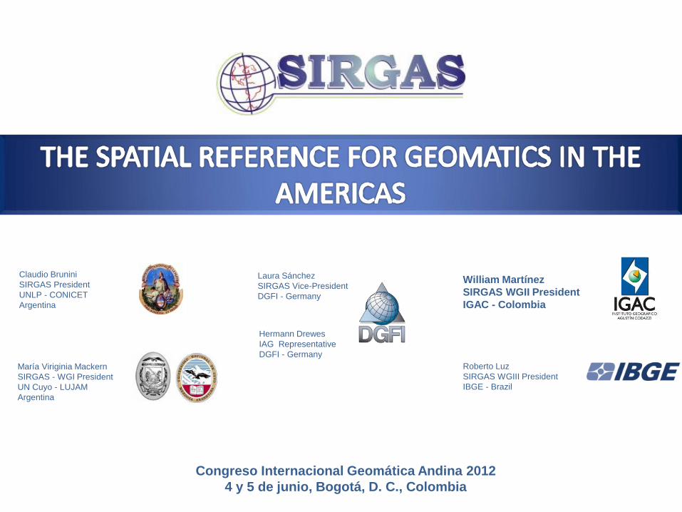
Claudio Brunini
SIRGAS President
UNLP - CONICET
Argentina
Roberto Luz
SIRGAS WGIII President
IBGE - Brazil
Hermann Drewes
IAG Representative
DGFI - Germany
María Viriginia Mackern
SIRGAS - WGI President
UN Cuyo - LUJAM
Argentina
Laura Sánchez
SIRGAS Vice-President
DGFI - Germany
William Martínez
SIRGAS WGII President
IGAC - Colombia
Congreso Internacional Geomática Andina 2012
4 y 5 de junio, Bogotá, D. C., Colombia

Congreso Internacional Geomática Andina 2012. 4 de junio, Bogotá, D. C., Colombia 2
DEFINITION
• SIRGAS as a reference system is defined as identical with the International Terrestrial Reference System (ITRS)
• SIRGAS as a reference frame is a regional densification of the International Terrestrial reference Frame (ITRF)
(a) The International Terrestrial Reference System (ITRS) (a) The International Terrestrial Reference Frame (ITRF) visualized as a distributed
set of ground control stations (represented by red points)
http://www.kartografie.nl
SIRGAS stands for Geocentric Reference System for the Americas
IAG Sub Commission 1.3b: Reference Frames / Regional Reference Frames / South and Central America
Working Group of the PAIGH Cartography Commission

Congreso Internacional Geomática Andina 2012. 4 de junio, Bogotá, D. C., Colombia 3
GEODESY
The science of accurately
measure and understand three fundamental properties of Earth: its geometric shape, its orientation in space, and its gravity field; and the changes of these properties with time (Precise
Geodetic Infrastructure: National Requirements for a Shared Resource. NAP, 2010)
The science for measuring changes in the Earth System
Reference frames
Earth rotation
Gravity field
Geokinematics
Congreso Internacional Geomática Andina 2012. 4 de junio, Bogotá, D. C., Colombia
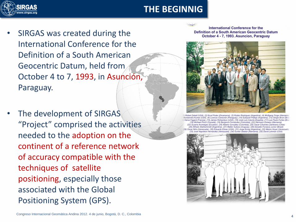
• SIRGAS was created during the International Conference for the Definition of a South American Geocentric Datum, held from October 4 to 7, 1993, in Asunción, Paraguay.
• The development of SIRGAS “Project” comprised the activities needed to the adoption on the continent of a reference network of accuracy compatible with the techniques of satellite positioning, especially those associated with the Global Positioning System (GPS).
4
THE BEGINNIG
Congreso Internacional Geomática Andina 2012. 4 de junio, Bogotá, D. C., Colombia
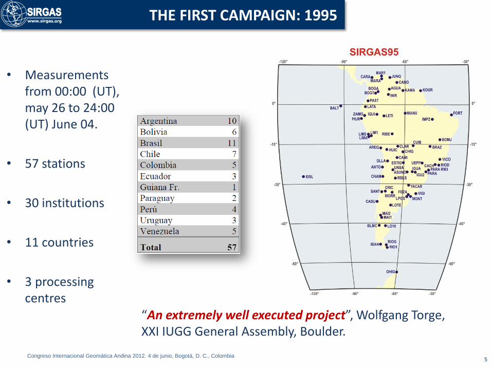
• Measurements from 00:00 (UT), may 26 to 24:00 (UT) June 04.
• 57 stations
• 30 institutions
• 11 countries
• 3 processing centres
5
THE FIRST CAMPAIGN: 1995
“An extremely well executed project”, Wolfgang Torge, XXI IUGG General Assembly, Boulder.
Congreso Internacional Geomática Andina 2012. 4 de junio, Bogotá, D. C., Colombia
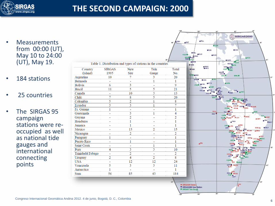
• Measurements from 00:00 (UT), May 10 to 24:00 (UT), May 19.
• 184 stations
• 25 countries
• The SIRGAS 95 campaign stations were re-occupied as well as national tide gauges and international connecting points
6
THE SECOND CAMPAIGN: 2000
Congreso Internacional Geomática Andina 2012. 4 de junio, Bogotá, D. C., Colombia 7
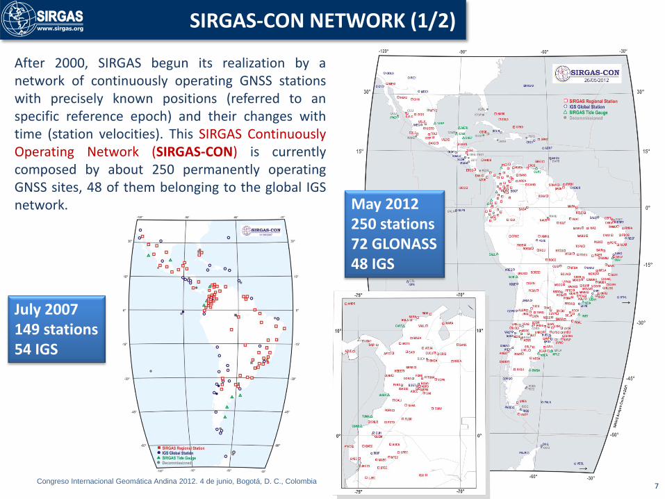
SIRGAS-CON NETWORK (1/2)
After 2000, SIRGAS begun its realization by a network of continuously operating GNSS stations with precisely known positions (referred to an specific reference epoch) and their changes with time (station velocities). This SIRGAS Continuously Operating Network (SIRGAS-CON) is currently composed by about 250 permanently operating GNSS sites, 48 of them belonging to the global IGS network.
July 2007 149 stations 54 IGS
May 2012 250 stations 72 GLONASS 48 IGS

Congreso Internacional Geomática Andina 2012. 4 de junio, Bogotá, D. C., Colombia
• National reference frames in Latin America are part of SIRGAS-CON.
• The core network (SIRGAS-CON-C) is the primary densification of ITRF in Latin America.
• Densification sub-networks (SIRGAS-CON-D) provide accessibility to the reference frame at local levels.
• Today, there are three SIRGAS-CON-D sub-networks, but in the future, there shall be given so many SIRGAS-CON-D sub-networks as countries in the region.
8
SIRGAS-CON NETWORK (2/2)

Congreso Internacional Geomática Andina 2012. 4 de junio, Bogotá, D. C., Colombia 9
STRUCTURE
1993 – 1997
1997 -2011
2011…
Congreso Internacional Geomática Andina 2012. 4 de junio, Bogotá, D. C., Colombia 10
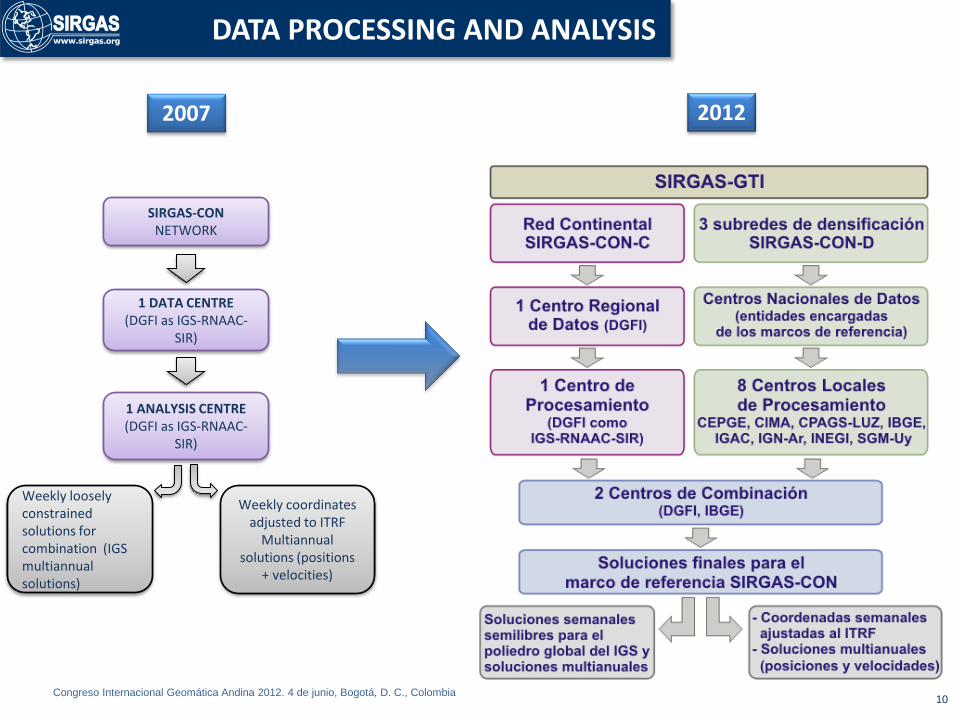
DATA PROCESSING AND ANALYSIS
SIRGAS-CON NETWORK
1 DATA CENTRE (DGFI as IGS-RNAAC-
SIR)
1 ANALYSIS CENTRE (DGFI as IGS-RNAAC-
SIR)
Weekly loosely constrained solutions for combination (IGS multiannual solutions)
Weekly coordinates adjusted to ITRF
Multiannual solutions (positions
+ velocities)
2007 2012
Congreso Internacional Geomática Andina 2012. 4 de junio, Bogotá, D. C., Colombia 11
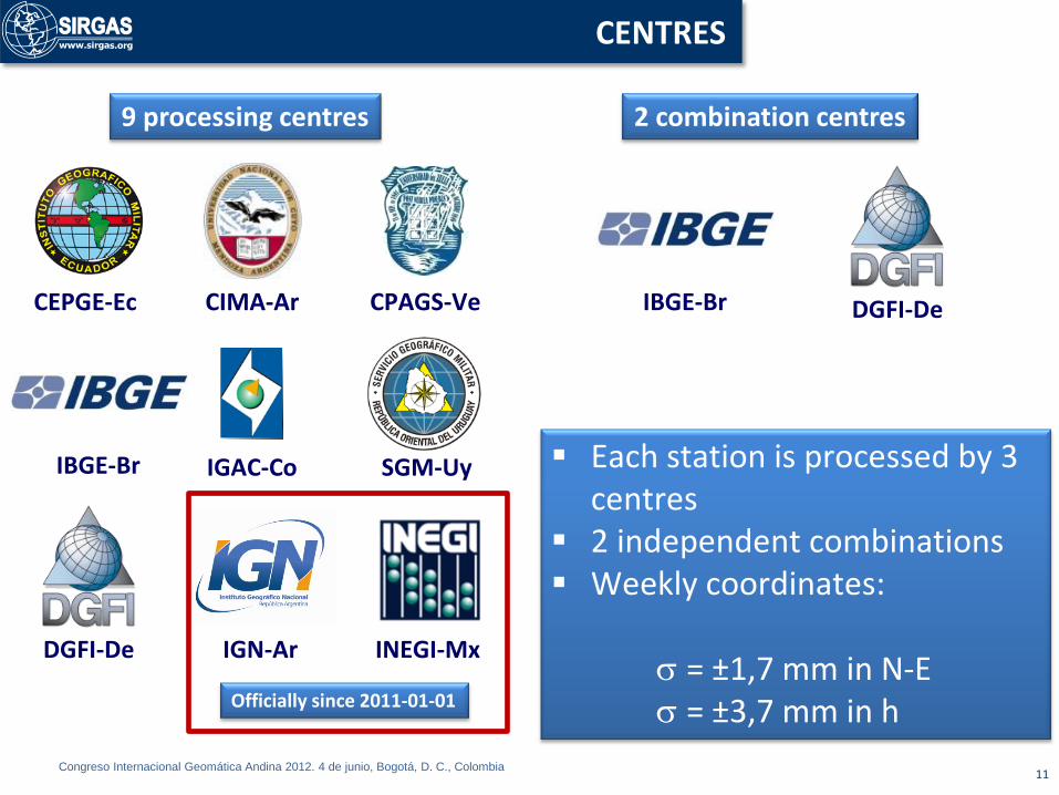
CENTRES
CEPGE-Ec CIMA-Ar CPAGS-Ve
IBGE-Br IGAC-Co SGM-Uy
DGFI-De IGN-Ar INEGI-Mx
Each station is processed by 3 centres
2 independent combinations Weekly coordinates: = ±1,7 mm in N-E = ±3,7 mm in h
IBGE-Br DGFI-De
Officially since 2011-01-01
9 processing centres 2 combination centres
Congreso Internacional Geomática Andina 2012. 4 de junio, Bogotá, D. C., Colombia 12
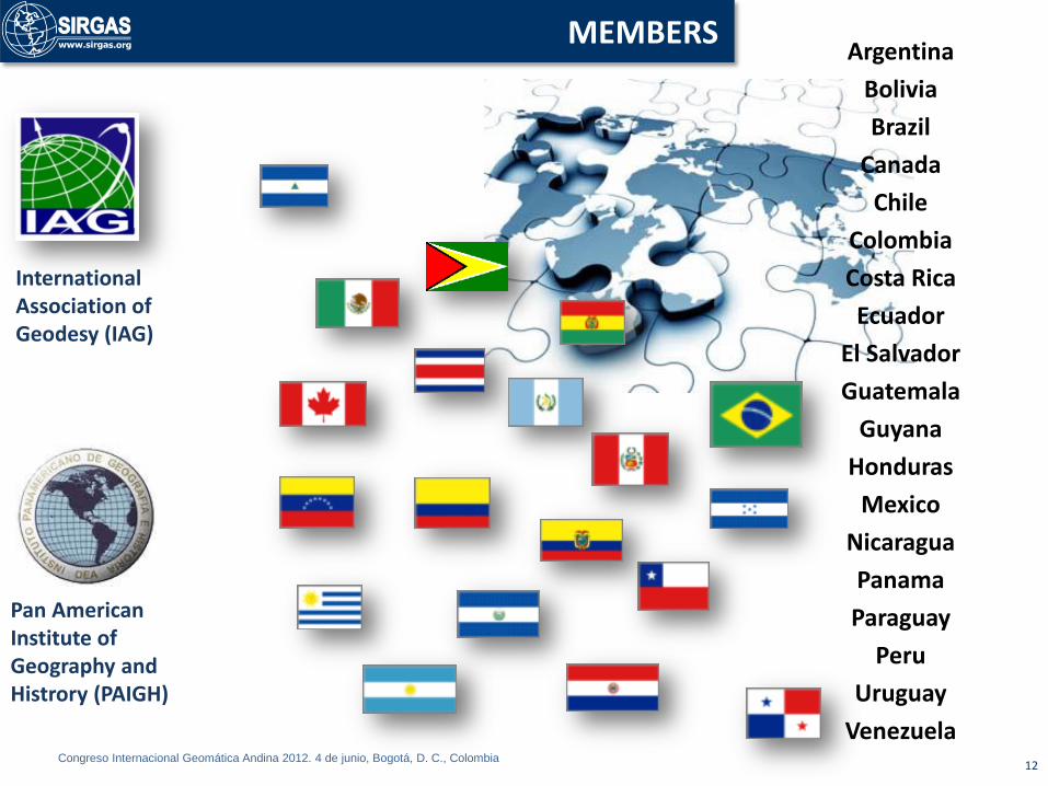
MEMBERS Argentina
Bolivia
Brazil
Canada
Chile
Colombia
Costa Rica
Ecuador
El Salvador
Guatemala
Guyana
Honduras
Mexico
Nicaragua
Panama
Paraguay
Peru
Uruguay
Venezuela
Pan American Institute of Geography and Histrory (PAIGH)
International Association of Geodesy (IAG)
Congreso Internacional Geomática Andina 2012. 4 de junio, Bogotá, D. C., Colombia 13
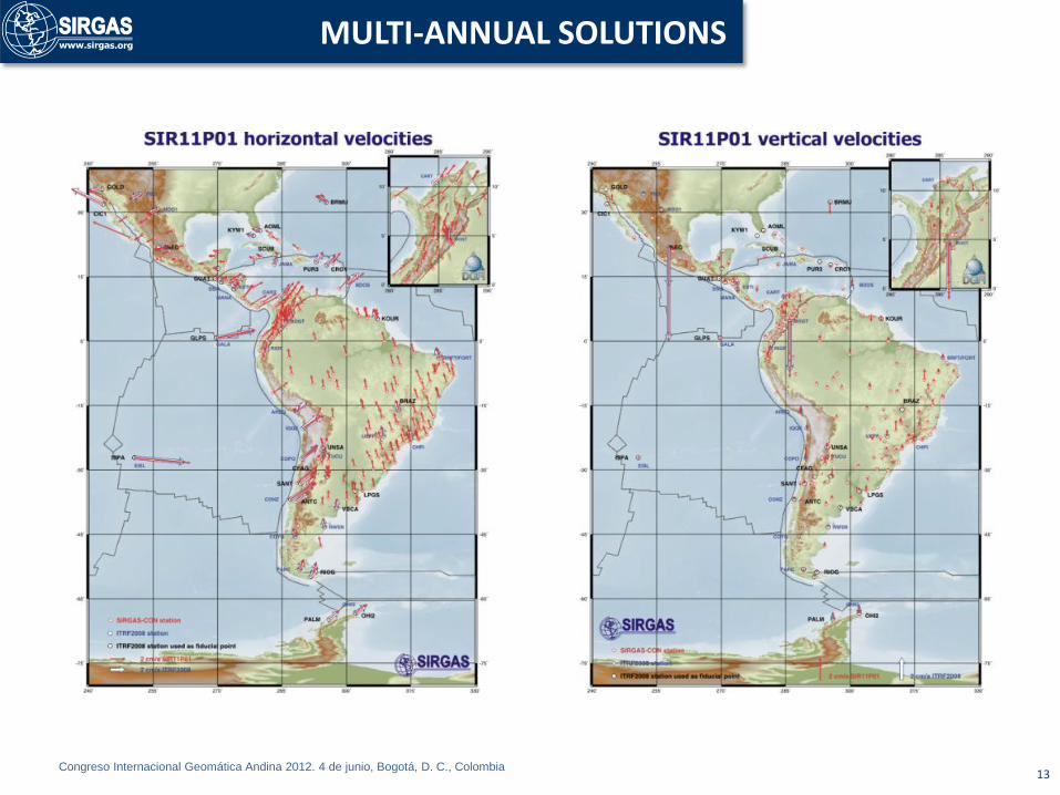
MULTI-ANNUAL SOLUTIONS

Congreso Internacional Geomática Andina 2012. 4 de junio, Bogotá, D. C., Colombia 14
VELOCITY MODELS
2003
Drewes, H. and O. Heidbach (2009).

Congreso Internacional Geomática Andina 2012. 4 de junio, Bogotá, D. C., Colombia 15
VERTICAL DATUM
In preparation
July 2007 July 2011
The new SIRGAS vertical reference system is based on a geometrical component that corresponds to ellipsoidal heights referred to the SIRGAS datum, and a physical component that is given in terms of geopotential quantities (W0 as a reference level and geopotential numbers as primary coordinates). Its realization should: i) Refer to a unified global reference level W0, ii) Be given by proper physical heights (derived from spirit levelling in combination with gravity reductions), and iii) Be associated to a specific reference epoch, i.e. it should consider the coordinate and referential changes with time.
The respective reference surface (geoid or quasi-geoid) shall be determined in a common analysis over the whole continent.

Congreso Internacional Geomática Andina 2012. 4 de junio, Bogotá, D. C., Colombia 16
ATMOSPHERIC RESEARCH
Evolution of the ionospheric model: 3-D representation of TEC and 4D of EC. Applications for the projects: • Augmentation Solution for the Caribbean, Central and South America (SACCSA) for ICAO. • Low Ionosphere Sensor network; • International Reference Ionosphere.
“Contribution to the Study of the Global Climatic Change and the Meteorological Prediction and the Space Weather: Argentina, Brazil, Colombia, Ecuador, Mexico, Venezuela and Uruguay” under the guidance of Virginia Mackern (approved PAIGH in 2010)

Congreso Internacional Geomática Andina 2012. 4 de junio, Bogotá, D. C., Colombia 17
REAL TIME
• Increasing number of stations that generate observations and corrections in real Time: installation of new casters and sharing of experiences that demonstrate the potential of the method, specially in Brazil, Uruguay, Argentina and Venezuela.
• At the beginning of 2011, the project “Evaluation of potential applications of NTRIP in SIRGAS” was presented to PAIGH with the participation of Uruguay, Argentina and Venezuela.
Congreso Internacional Geomática Andina 2012. 4 de junio, Bogotá, D. C., Colombia
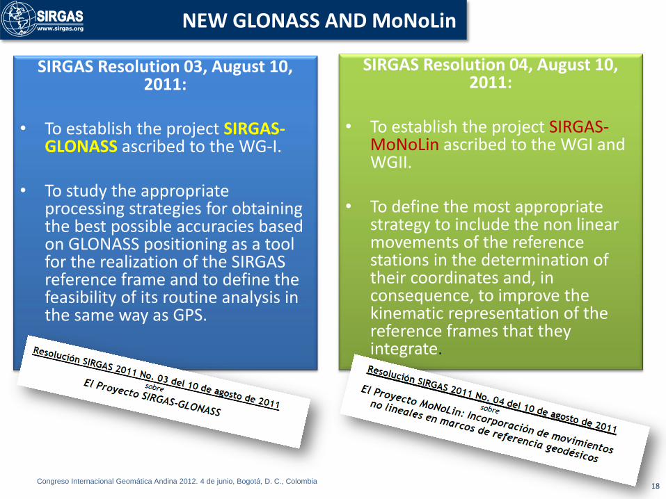
SIRGAS Resolution 03, August 10, 2011:
• To establish the project SIRGAS-
GLONASS ascribed to the WG-I.
• To study the appropriate processing strategies for obtaining the best possible accuracies based on GLONASS positioning as a tool for the realization of the SIRGAS reference frame and to define the feasibility of its routine analysis in the same way as GPS.
18
NEW GLONASS AND MoNoLin
SIRGAS Resolution 04, August 10, 2011:
• To establish the project SIRGAS-
MoNoLin ascribed to the WGI and WGII.
• To define the most appropriate strategy to include the non linear movements of the reference stations in the determination of their coordinates and, in consequence, to improve the kinematic representation of the reference frames that they integrate.

Congreso Internacional Geomática Andina 2012. 4 de junio, Bogotá, D. C., Colombia 19
CAPACITY BUILDING
• Specialized courses for the establishment of the SIRGAS analysis centres
- Instituto Geográfico Militar de Ecuador, December 2008 and February 2011.CEPGE-IGM
- Servicio Geográfico Militar del Uruguay, March 2009
• SIRGAS Schools on Reference Systems
- First: Bogotá, July 2009, IGAC, 120 participants, 12 countries.
- Second: Lima, November 2010, IGN, 122 participants, 13 countries.
- Third: Heredia, August 2011, ETCG, 116 participants, 18 countries
• SIRGAS Chapter in Advanced Course of Satellite Positioning: AECID
- Universidad Politécnica de Madrid, November 2009
- Montevideo , May 2010
- Universidad Politécnica de Madrid, November 2010
Congreso Internacional Geomática Andina 2012. 4 de junio, Bogotá, D. C., Colombia 20
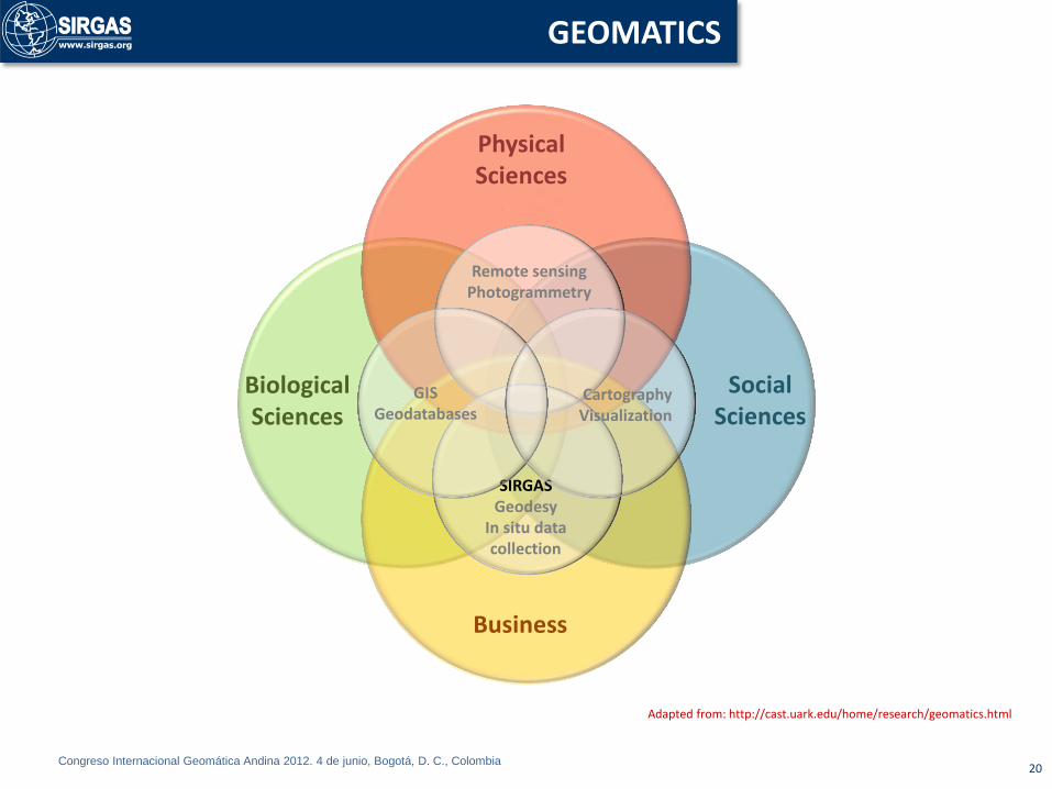
GEOMATICS
Social Sciences
Physical Sciences
Biological Sciences
Business
Remote sensing Photogrammetry
Adapted from: http://cast.uark.edu/home/research/geomatics.html
SIRGAS Geodesy
In situ data collection
GIS Geodatabases
Cartography Visualization
Congreso Internacional Geomática Andina 2012. 4 de junio, Bogotá, D. C., Colombia 21
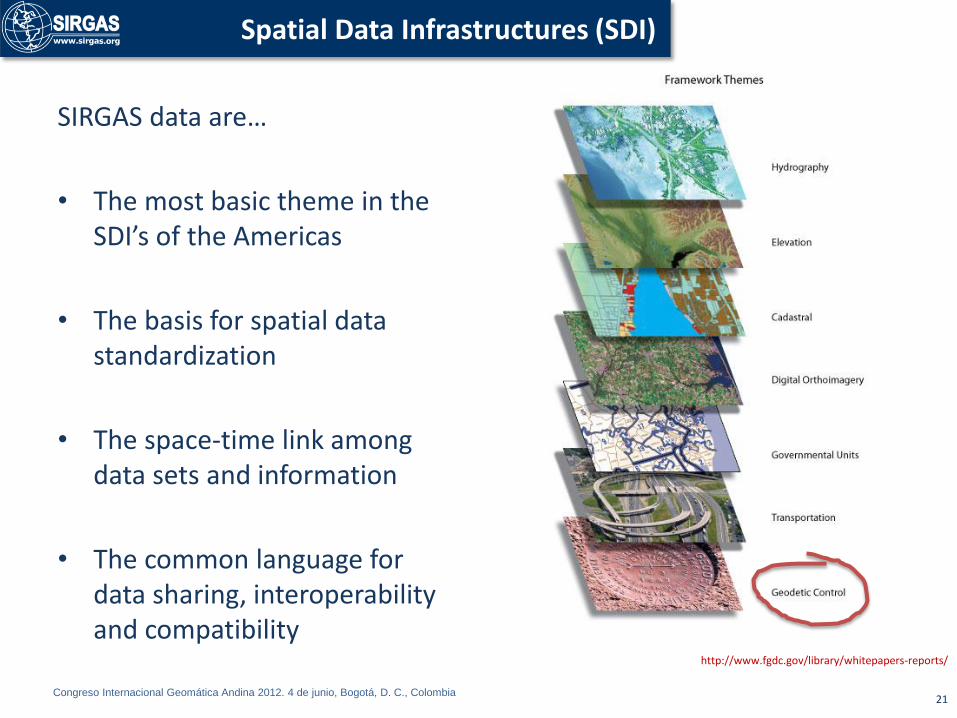
Spatial Data Infrastructures (SDI)
http://www.fgdc.gov/library/whitepapers-reports/
SIRGAS data are…
• The most basic theme in the SDI’s of the Americas
• The basis for spatial data standardization
• The space-time link among data sets and information
• The common language for data sharing, interoperability and compatibility

Congreso Internacional Geomática Andina 2012. 4 de junio, Bogotá, D. C., Colombia
• As the contribution of geodetic science and techniques to the family of Earth sciences by sharing data, providing services and generating information that combined with those provided by different sources lead to a better comprehension of Earth.
EARTH SCIENCE

Congreso Internacional Geomática Andina 2012. 4 de junio, Bogotá, D. C., Colombia
• Working on a SIRGAS basis, implies the use of the ITRF
• World Geodetic System WGS84 was adjusted to ITRF and, nowadays they are equivalent.
• The practical use of SIRGAS involves a referencing to the International Terrestrial Reference Frame (ITRF).
• SIRGAS, ITRF and WGS84 are equivalent
23
IN THE PRACTICE: DEFINITIONS
http://www.dgfi.badw.de/index.php?id=2

Congreso Internacional Geomática Andina 2012. 4 de junio, Bogotá, D. C., Colombia
Country Name Datum Reference epoch
Argentina POSGAR ITRF2005 2006,6
Bolivia MARGEN SIRGAS95 1995,4
Brazil SIRGAS2000 SIRGAS2000 2000,4
Chile SIRGAS-CHILE SIRGAS2000 2002
Colombia MAGNA-SIRGAS SIRGAS95 1995,4
Costa Rica CR05 ITRF2000 2005,8
Ecuador RED BÁSICA SIRGAS95 1995,4
El Salvador SIRGAS ES-2007 SIRGAS-ES2007 2007,8
French Guyana RGFG ITRF93 1995
Mexico RGNA ITRF92 1988
Panama ITRF2000 2000
Peru PERU96 SIRGAS95 1995,4
Uruguay SIRGAS-ROU-98 SIRGAS95 1995,4
Venezuela SIRGAS-REGVEN SIRGAS95 1995,4
24
• At present, member countries are implementing strategies to adopt the last version: ITRF08. GPS broadcasted information is compatible with it.
Congreso Internacional Geomática Andina 2012. 4 de junio, Bogotá, D. C., Colombia
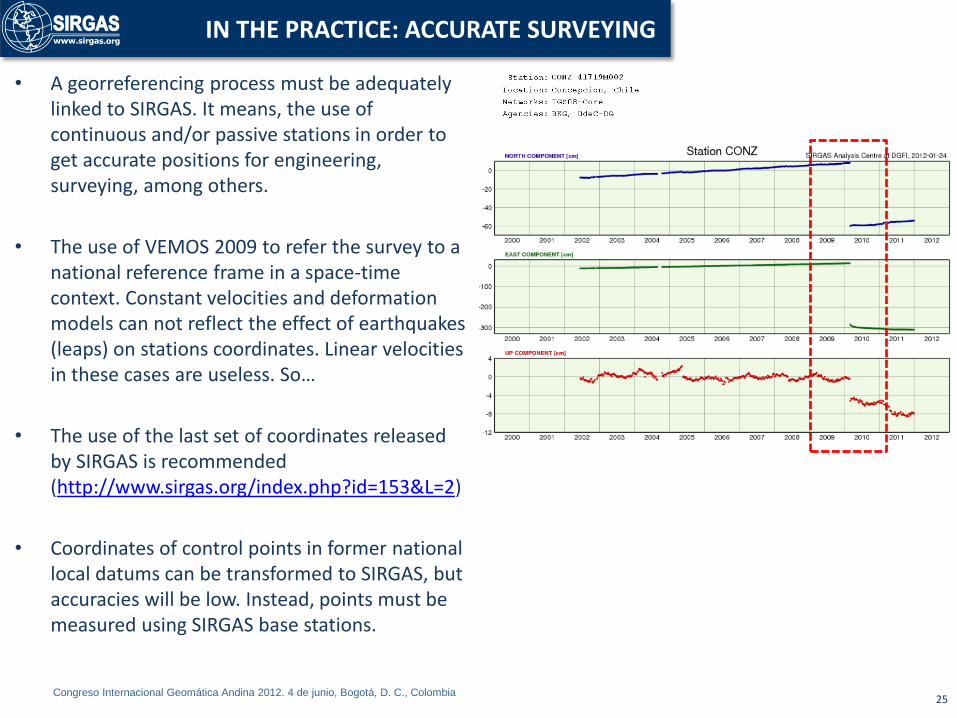
• A georreferencing process must be adequately linked to SIRGAS. It means, the use of continuous and/or passive stations in order to get accurate positions for engineering, surveying, among others.
• The use of VEMOS 2009 to refer the survey to a national reference frame in a space-time context. Constant velocities and deformation models can not reflect the effect of earthquakes (leaps) on stations coordinates. Linear velocities in these cases are useless. So…
• The use of the last set of coordinates released by SIRGAS is recommended (http://www.sirgas.org/index.php?id=153&L=2)
• Coordinates of control points in former national local datums can be transformed to SIRGAS, but accuracies will be low. Instead, points must be measured using SIRGAS base stations.
25
IN THE PRACTICE: ACCURATE SURVEYING

Congreso Internacional Geomática Andina 2012. 4 de junio, Bogotá, D. C., Colombia
• Satellite imagery is normally referred to ITRF (WGS84). In consequence, it is recommended that local ground control be made linked to SIRGAS.
• Maps elaborated using a former national datum should be transformed to SIRGAS. The inverse process decreases the accuracy and quality of results. SIRGAS countries have computed national transformation parameters. Even so, in the most of cases, global transformation parameters are valid for mapping purposes.
• GNSS measurements do not eliminate the electro-optical surveys. They are complementary processes: GNSS establishes the datum, and EDM´s gets detailed information, mainly in places where satellite signals are not available and/or no practical.
• Field measured positions, after a survey like traverses or GNSS accurate positioning have their own accuracies. They cannot be “mixed” with a cartographic product assuming full compatibility. Usually, errors in a map are, by far, greater than those of control points.
• Plane (projected) coordinates of control points can be assumed with the same accuracy than original geocentric Cartesian or geographic coordinates. This is valid if the SIRGAS frame is used for both data sets. This process is called conversion; different than transformation, which implies a shift between reference frames.
• Natural features must be avoided as reference for parcel delimitations. Instead, SIRGAS coordinates are recommended. Even if they change with time, areas normally keep their dimension.
26
IN THE PRACTICE: MAPPING AND CADASTRE

Congreso Internacional Geomática Andina 2012. 4 de junio, Bogotá, D. C., Colombia
Thank you very much
27