oficina de estudios y politicas agrarias ......2 1999: panorama de la agricultura chilena / chilean...
TRANSCRIPT

1
OFICINA DE ESTUDIOS Y POLITICAS AGRARIAS
MINISTERIO DE AGRICULTURA
CHILEAN AGRICULTURE OVERVIEW 1999

2
1999: Panorama de la agricultura chilena / Chilean agriculture overview 1999
Publicación de la Oficina de Estudios y Políticas Agrarias -ODEPA-Ministerio de AgriculturaAgosto 1999
ISBN 956-7244-13-8Registro de Propiedad Intelectual Nº 110213
Director y Representante LegalCarlos Furche Guajardo
Informaciones en:Centro de Información Silvoagropecuaria -CIS-Valentín Letelier 1339 - Código Postal 6501070Fono: 696 3241 anexo 212 - Fax: 671 8809www.odepa.gob.cl
Diseño, Diagramación e ImpresiónCAUPOLICAN Servicios GráficosDieciocho 786 - Santiago - ChileFono: 671 6467; Fax: 671 6330www.caupolican.cl
3
DESCRIPCION GENERALGENERAL DESCRIPTION

46
Indice del capítulo: DESCRIPCION GENERAL
Algunos antecedentes demográficos ............................. 5
Breve reseña geográfica .................................................. 6
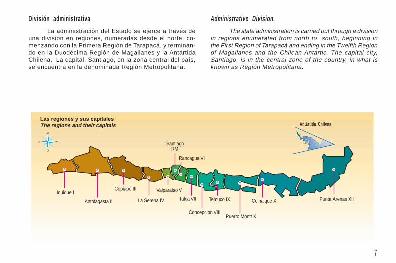
División administrativa ..................................................... 7
Climas ................................................................................ 8
Temperaturas y lluvias ................................................... 10
Las macrorregiones ......................................................... 11
Suelo agrícola ................................................................. 12
Cobertura censal ............................................................ 13
Explotaciones agropecuarias y forestales ................... 14
Uso del suelo .................................................................. 15
Tamaño de las explotaciones ........................................ 18
Condición jurídica de los productores ......................... 20
Tenencia ........................................................................... 21
GENERAL DESCRIPTION - Index
Some Demographic Data ................................................. 5
A Brief Geographical Description ................................... 6
Administrative Division ..................................................... 7
Climates ............................................................................. 8
Temperatures and Rainfalls ........................................... 10
The Macro-Regions ......................................................... 11
Agricultural Land ............................................................. 12
Census Cover .................................................................. 13
Agricultural and Forestry Farms ................................... 14
Land Use .......................................................................... 15
Size of Farms ................................................................. 18
Legal Status of Producers ............................................. 20
Estate Holding ................................................................. 21

5
0
10
20
30
40
50
60
%
Algunos antecedentes demográficosLas estadísticas demográficas del país muestran
un país de crecimiento demográfico moderado (aproxima-damente 1,5% anual), con una tasa de nacimientos del19,3 ‰ y una tasa de mortalidad del 5,5 ‰ (1996). Laestructura de la distribución de la población por sexo ygrupos de edad muestra un país relativamente joven, conun buen equilibrio entre los diferentes segmentos.
La esperanza de vida al nacer es de 75,21 años parael período 1995-2000.
Porcentaje rural 14,8%Rural percentage: 14.8%
Participación mujeres 50,5%Percentage of women: 50.5%
Participación hombres 49,5%Percentage of men: 49.5%
Fuente: Elaborado por ODEPA con información del INE.Source: Developed by ODEPA; based on INE data.
Some Demographic DataThe national statistics show the country is experiencing
a moderate demographic growth -approximately 1.5% peryear- with a 19.3‰ birth rate and a 5.5‰ death rate (1996).The structure of the population distribution by sex and groupsof age reveals a relatively young nation with a fair balanceamong its different segments.
In the 1995-2000 period the life expectancy at birthis 75.21 years.

6
Breve reseña geográficaChile continental, ubicado en el extremo sur-occi-
dental de América, presenta una geografía extraordinaria:con más de 4.200 km de largo, muy angosto, con un anchomáximo de 375 km y uno mínimo de unos 90 km, conformauna estrecha lengua de tierra custodiada en todo su largopor dos grandes cordilleras: de los Andes y de la Costa.Esta doble espina dorsal acuna la llamada Depresión In-termedia. Pese a que en distintas regiones estas caracte-rísticas del terreno se alteran, vuelven a reaparecer poste-riormente, hasta perderse en el mar en el sur del país.
Al Este, laCordillera de losAndes, con cum-bres muy altas(cercanas a los7.000 m), forma ellímite natural conArgentina y Boli-via; en tanto que,al Oeste, las altu-ras de la Cordillerade la Costa sonmenores —un máximo de 3.000 m en el norte— y van dis-minuyendo a medida que se avanza al sur. En las zonasdel Norte Chico y Central existen, además, los llamadosValles Transversales, que van de la Cordillera de Los An-des a la de La Costa. Estas particularidades hacen que elterreno plano sea escaso en relación al total: aproximada-mente un 20% de sus 756.000 km2.
A brief geographical description.Continental Chile, placed along the southwestern end
of America, shows extraordinary geographical features: itconstitutes a narrow strip of land whose length stretchesover 4,200 km while its width oscillates from a maximum of375 km to a minimum of only 90 km. This extension of landis sheltered by two great mountain ranges, the Cordillerade los Andes and the Cordillera de la Costa. In turn, thisdouble spine houses the so called Intermediate Depression.Although these physical features change in some regions,they appear again until they vanish in the southern sea.
To the east,the high mountainpeaks of the Andes(around 7,000m)represent the natu-ral boundary with Ar-gentina and Bolivia.Meanwhile, to thewest, the heights ofthe Cordillera de laCosta are lower -witha maximum of
3,000m in the north- decreasing gradually southwards. Inthe natural regions called Little North and Central Zone thereexist what is known as transversal valleys, which go downfrom the Andes to the Cordillera de la Costa. These peculiaritiesmake plain lands scarce in comparison with the total areaof the country, that is, approximately, 29% out of the total756,000 km2.
7
Iquique I
Antofagasta II
Copiapó III
La Serena IV
Valparaíso V
Santiago RM
Rancagua VI
Talca VII
Concepción VIII
Temuco IX
Puerto Montt X
Coihaique XI Punta Arenas XII
N S
EO
División administrativaLa administración del Estado se ejerce a través de
una división en regiones, numeradas desde el norte, co-menzando con la Primera Región de Tarapacá, y terminan-do en la Duodécima Región de Magallanes y la AntártidaChilena. La capital, Santiago, en la zona central del país,se encuentra en la denominada Región Metropolitana.
Administrative Division.The state administration is carried out through a division
in regions enumerated from north to south, beginning inthe First Region of Tarapacá and ending in the Twelfth Regionof Magallanes and the Chilean Antartic. The capital city,Santiago, is in the central zone of the country, in what isknown as Región Metropolitana.
Las regiones y sus capitalesThe regions and their capitals Antártida Chilena

8
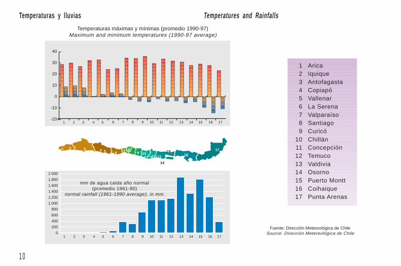
ClimasLa extrema longitud del país, sumada a otras carac-
terísticas como son las barreras naturales que forman lascordilleras y las corrientes marinas subtropicales en el nor-te y polares desde el sur, tienen como resultado una grandiversidad de climas en el territorio, los que se expresan nosolamente en sentido latitudinal sino que también en su perfiltransversal. Los climas del país van desde los de tipo des-értico en el norte, con precipitación promedio de menos de1 mm/año, a los templados lluviosos fríos en el extremo sur,con lugares cuyas lluvias superan los 5.000 mm/año. Estopermite una gran variedad de formas de vida animal y vege-tal, que son la base del diversificado desarrollo agrícola yforestal del país.
ClimatesAs a result of the unusual length of the country, in
addition to other features such as the natural barriers formedby the mountain ranges and the subtropical oceanic currentsin the north, as well as the polar ones coming from the south,there is a great diversity of climates along the territory whichmake themselves evident not only in the latitudinal but alsoin the longitudinal direction. The country climates range fromthe arid ones in the north, with average rainfalls less than1mm per year, to the mildly cold rainy ones in the southend, with areas in which the average rainfalls exceed 5,000mmper year. All this makes possible the existence of a greatvariety of animal and vegetal life forms, that, in turn, constitutethe basis of the diversified agricultural and forestry developmentof the nation.

9
N S
EO
Tropical lluvioso
Desértico normal
Desértico frío
Desértico connublados abundantes
Desértico cálidonublados abundantes
Semiárido templadocon lluvias invernales
Semiárido connublados abundantes
Semiárido frío conlluvias invernales
Templado cálido conlluvias invernales y grannubosidad
Templado cálido conlluvias invernales
Templado cálido con lluviasinvernales y gran humedadatmosférica
Templado frío con lluviasinvernales
Templado cálido lluviosocon influencia mediterránea
Templado frío lluviosocon influenciamediterránea
Tundra
Templado frío lluviososin estación seca
Templado cálido lluviososin estación seca
Tundra por efecto de altura
Tundra por efecto de alturacon precipitación estival
Tundra por efecto de alturacon escasa o nula precipitación
Polar por efecto de altura
Polar
Tundra due to altitude
Polar
Polar due to altitude
Tundra due to altitude withscarce or no rainfalls
Tundra due to altitude withsummer rainfalls
Mildly cold rainywith inlandinfluence
Tundra
Mildly cold rainywithout dry season
Mildly warm rainywithout dry season
Mildly warm with winterrains and high atmospherichumidity
Mildly cold with winterrains
Mildly warm rainy withinland influence
Cloudy semiarid
Temperate semiaridwith winter rains
Mildly warm withwinter rains and greatcloudiness
Rainy tropical
Arid, normal
Arid, cold
Arid, cloudy
Arid, warm andcloudy
Cold semiarid withwinter rains
Mildly warm with winterrains
Antártida Chilena
1 0
-20
-10
0
10
20
30
40
6 7 8 9 10 11 12 13 14 15 16 17
1 2 3 4 5 6 7 89 10
11 12 13
14
1516
17
1 2 3 4 5 6 7 8 9 10 11 12 13 14 15 16 17
1 2 3 4 5
0
200
400
600
800
1.000
1.200
1.400
1.600
1.800
2.000
Temperaturas y lluvias Temperatures and Rainfalls
Temperaturas máximas y mínimas (promedio 1990-97)Maximum and minimum temperatures (1990-97 average)
Fuente: Dirección Meteorológica de ChileSource: Dirección Metereológica de Chile
1 Arica2 Iquique3 Antofagasta4 Copiapó5 Vallenar6 La Serena7 Valparaíso8 Santiago9 Curicó
10 Chillán11 Concepción12 Temuco13 Valdivia14 Osorno15 Puerto Montt16 Coihaique17 Punta Arenas
mm de agua caida año normal(promedio 1961-90)
normal rainfall (1961-1990 average), in mm.
1 1
Norte GrandeHortofruticultura,Ganadería de Camélidos
CentroHortofruticultura,Vitivinicultura,Cultivos Anuales
Sur FronteraCereales,Ganadería: Crianza-Engorda,Actividad Forestal
Extremo SurGanadería Ovina y BovinaActividad Forestal
Norte ChicoHortofruticultura,Actividad Pisquera,Ganadería Caprina
Centro SurCultivos Anuales,Vitivinicultura,Actividad Forestal
Sur: Zona de Los LagosGanadería Bovina: Lechería,Actividad Forestal
N S
EO
Little NorthHorticulturePisco productionGoat raising
Central SouthAnnual cropsViniculture andWine productionForestry
Great NorthHorticulture,Camelid raising
CenterHorticultureViniculture andWine productionAnnual crops
South: The FrontierCerealsLivestock: raising and fatteningForestry
Extreme SouthSheep and cattleForestry
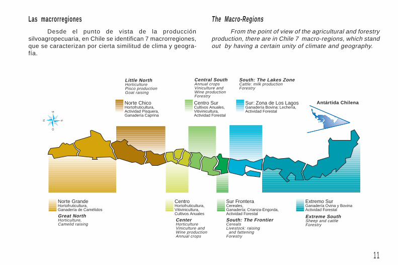
Las macrorregionesDesde el punto de vista de la producción
silvoagropecuaria, en Chile se identifican 7 macrorregiones,que se caracterizan por cierta similitud de clima y geogra-fía.
From the point of view of the agricultural and forestryproduction, there are in Chile 7 macro-regions, which standout by having a certain unity of climate and geography.
South: The Lakes ZoneCattle: milk productionForestry
The Macro-Regions
Antártida Chilena

1 2
Esquema de terrenos con potencial silvoagropecuarioDiagram of land with agricultural and forestry potential
50,4
25.2Agriculture
Agricultural Land.
5,1 CultivablesTillable8,5
GanaderaLivestock
11,6ForestalForestry
1,8
1,3 2
RiegoIrrigated soil
Suelo agrícolaDe los 75,6 millones de hectáreas de Chile conti-
nental, sólo aproximadamente un tercio tiene potencialsilvoagropecuario. Esta superficie se subdivide del modosiguiente:
8,5 millones de hectáreas: aptitud ganadera
11,6 millones de hectáreas: aptitud forestal
5,1 millones de hectáreas: arables o cultivables(1,8 con riego y 1,3 potencialmente regables;2 de secano).
SecanoDryland
Potencialmente regablesIrrigation possibilities
Out of the 75.6 million hectares of continental Chile,approximately one third has aptitude for agriculture and forestry.This area is divided as follows:
8.5 million hectares: livestock raising aptitude.
11.6 million hectares: forestry potential.
5.1 million hectares: tillable land (1.8 of irrigatedsoil; 1.3 of soil with irrigation possibilities; and,2.0 of dryland)
Total con potencial cultivable,5,1 millones de hectáreas.
Total tillable land:5.1 million hectares
Total con potencialsilvoagropecuario,
25,2 millones de hectáreas.Total land with agricultural
and forestry potential:25.2 million hectares
Total Chile Continental,75,6 millones de hectáreas.
Total area of continental Chile:75.6 million hectares
1 3
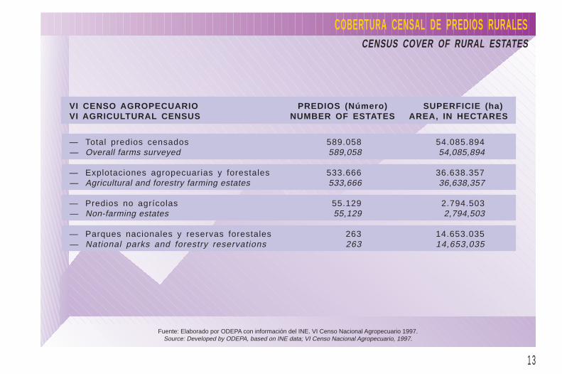
COBERTURA CENSAL DE PREDIOS RURALESCENSUS COVER OF RURAL ESTATES
Fuente: Elaborado por ODEPA con información del INE. VI Censo Nacional Agropecuario 1997.Source: Developed by ODEPA, based on INE data; VI Censo Nacional Agropecuario, 1997.
VI CENSO AGROPECUARIO PREDIOS (Número) SUPERFICIE (ha)VI AGRICULTURAL CENSUS NUMBER OF ESTATES AREA, IN HECTARES
— Total predios censados 589.058 54.085.894— Overall farms surveyed 589,058 54,085,894
— Explotaciones agropecuarias y forestales 533.666 36.638.357— Agricultural and forestry farming estates 533,666 36,638,357
— Predios no agrícolas 55.129 2.794.503— Non-farming estates 55,129 2,794,503
— Parques nacionales y reservas forestales 263 14.653.035— National parks and forestry reservations 263 14,653,035

1 4
0
10.000
20.000
30.000
40.000
50.000
60.000
70.000
XIIXIXIXVIIIVIIVIR.M.VIVIIIIIIREGIONES
EXPLOTACIONES AGROPECUARIAS Y FORESTALES / UnidadesAGRICULTURAL AND FORESTRY FARMS / UNITS
Nº ExplotacionesAgropecuarias
Number of agriculturalfarms
ExplotacionesFarming Estates
Fuente: Elaborado por ODEPA con información del INE. VI Censo Nacional Agropecuario 1997.Source: Developed by ODEPA, based on INE data; VI Censo Nacional Agropecuario, 1997.
Nº ExplotacionesForestales
Number of forestryfarms

1 5
0
500.000
1.000.000
1.500.000
2.000.000
2.500.000
3.000.000
3500.000
4.000.000
REGIONESXIIXIXIXVIIIVIIVIR.M.VIVIIIIII
SuperficieAgropecuarias
Area ofagricultural farms
SuperficieSurface
EXPLOTACIONES AGROPECUARIAS Y FORESTALES / SuperficieAGRICULTURAL AND FORESTRY FARMS / AREA
Fuente: Elaborado por ODEPA con información del INE. VI Censo Nacional Agropecuario 1997.Source: Developed by ODEPA, based on INE data; VI Censo Nacional Agropecuario, 1997.
SuperficieForestales
Area offorestry farms

1 6
2.500.000
0
500.000
1.000.000
1.500.000
2.000.000
REGIONESXIIXIXIXVIIIVIIVIR.M.VIVIIIIII
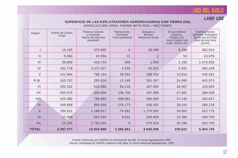
USO DEL SUELOLAND USE
Superficie de las Explotaciones Agropecuarias con Tierra / HectáreasArea of Agricultural Farms with Soil / hectares
Fuente: Elaborado por ODEPA con información del INE. VI Censo Nacional Agropecuario 1997.Source: Developed by ODEPA, based on INE data; VI Censo Nacional Agropecuario, 1997.
Praderas Naturalesy MejoradasNatural and developedgrasslands
Estériles, Aridos(arenales, pedregales)Barren and arid fields(sand pits and stonyground)
De uso indirecto(caminos, canales, etc.)Area of indirect use(roads, ditches, etc.)
Bosques y MontesWoods and Scrubs
Plantaciones ForestalesForest plantations
Suelos de CultivoCrops area
1 7
I 13.425 475.885 0 19.599 5.188 382.910
II 5.056 24.550 71 2 53 10.979
III 29.800 418.733 590 1.059 1.182 1.579.936
IV 191.718 3.072.357 4.233 44.031 3.331 565.428
V 141.964 788.164 38.264 168.336 10.815 245.431
R.M. 163.707 283.824 13.140 281.357 24.990 443.573
VI 262.152 533.880 66.218 287.584 18.367 118.904
VII 355.076 925.066 106.700 447.985 27.981 368.538
VIII 425.489 788.883 508.081 584.690 37.140 282.627
IX 409.688 965.658 276.173 506.491 29.191 180.129
X 269.811 1.196.817 74.281 1.175.592 34.602 312.775
XI 17.096 691.940 8.811 546.854 12.384 269.765
XII 12.296 2.759.203 0 579.626 30.396 543.745
TOTAL 2.297.277 12.924.959 1.096.561 4.643.206 235.621 5.304.740
USO DEL SUELOLAND USE
SUPERFICIE DE LAS EXPLOTACIONES AGROPECUARIAS CON TIERRA (HA)AGRICULTURE AREA: FARMS WITH SOIL / HECTARES
Región Suelos de CultivoCrops
Praderas naturalesy mejoradas
Natural and improvedgrasslands
Plantacionesforestales
Forest plantations
Bosques yMontes
Woods and Scrubs
De uso indirecto(Caminos,
Canales, etc)Area of indirect use
(roads, ditches, etc.)
Estériles Aridos(Arenales, Pedregales)Barren and arid fields(sand pits and stony
ground)
Fuente: Elaborado por ODEPA con información del INE. VI Censo Agropecuario 1997.Source: Developed by ODEPA, based on INE data; VI Censo Nacional Agropecuario, 1997.
1 8
0
10.000
20.000
30.000
40.000
50.000
60.000
70.000
80.000
90.000
100.000
> 1 ha 1 < 5 ha 5 < 10 ha 10 < 20 ha 20 < 50 ha 50 < 100 ha 100 < 500 ha 500 < 2.000 ha ≥ 2.000 ha
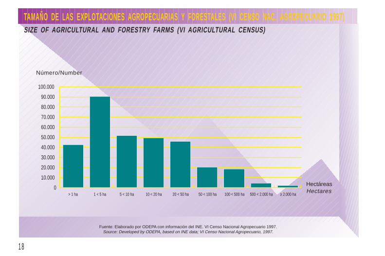
TAMAÑO DE LAS EXPLOTACIONES AGROPECUARIAS Y FORESTALES (VI CENSO NAC. AGROPECUARIO 1997)SIZE OF AGRICULTURAL AND FORESTRY FARMS (VI AGRICULTURAL CENSUS)
Fuente: Elaborado por ODEPA con información del INE. VI Censo Nacional Agropecuario 1997.Source: Developed by ODEPA, based on INE data; VI Censo Nacional Agropecuario, 1997.
Número/Number
HectáreasHectares

1 9
0
5.000.000
10.000.000
15.000.000
20.000.000
25.000.000
> 1 ha 1 < 5 ha 5 < 10 ha 10 < 20 ha 20 < 50 ha 50 < 100 ha 100 < 500 ha 500 < 2.000 ha ≥ 2.000 ha
TAMAÑO DE LAS EXPLOTACIONES AGROPECUARIAS Y FORESTALES (VI CENSO NAC. AGROPECUARIO 1997)SIZE OF AGRICULTURAL AND FORESTRY FARMS (VI AGRICULTURAL CENSUS)
Fuente: Elaborado por ODEPA con información del INE. VI Censo Nacional Agropecuario 1997.Source: Developed by ODEPA, based on INE data; VI Censo Nacional Agropecuario, 1997.
HectáreasHectares
Superficie/Area

2 0
CONDICION JURIDICA DE LOS PRODUCTORES(AS)LEGAL STATUS OF PRODUCERS
Fuente: Elaborado por ODEPA con información del INE. VI Censo Nacional Agropecuario 1997.Source: Developed by ODEPA, based on INE data; VI Censo Nacional Agropecuario, 1997.
NOTAS: (1) No se consultó en la XI RegiónNOTES: (1) Question not inquired in the XI Region.
(2) Ordenes religiosas, escuelas técnicas. Incluye sociedades anónimas y de responsabilidad limitada en las regiones I, XI y XII.(2) Religious orders, technical schools. Includes corporations and limited partnerships in the I, XI and XII Regions.
NUMERO SUPERFICIE (ha)NUMBER AREA (HECTARES)
Personas naturales 308.006 16.541.089Natural Persons
Productor(a) individual 282.204 13.020.124Independent producer
Sucesiones o sociedades de hecho (1) 25.802 3.520.965Hereditary or de facto partnerships (1)
Personas jurídicas 8.486 9.961.275Legal entities
Sector público (instituciones fiscales y municipales) 717 1.904.041Public sector (Fiscal agencies and municipal institutions)
Sociedades anónimas y de responsabil idad limitada 6.655 5.118.134Corporations and limited partnerships
Otras sociedades con contrato legal (2) 838 1.164.011Other partnerships existing as legal entities (2)
Comunidades indígenas y agrícolas (históricas) 276 1.775.089Native and agriculture (historical) communities
2 1
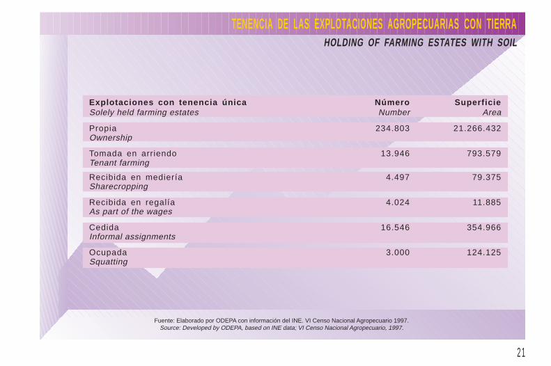
TENENCIA DE LAS EXPLOTACIONES AGROPECUARIAS CON TIERRAHOLDING OF FARMING ESTATES WITH SOIL
Fuente: Elaborado por ODEPA con información del INE. VI Censo Nacional Agropecuario 1997.Source: Developed by ODEPA, based on INE data; VI Censo Nacional Agropecuario, 1997.
Explotaciones con tenencia única Número SuperficieSolely held farming estates Number Area
Propia 234.803 21.266.432Ownership
Tomada en arriendo 13.946 793.579Tenant farming
Recibida en mediería 4.497 79.375Sharecropping
Recibida en regalía 4.024 11.885As part of the wages
Cedida 16.546 354.966Informal assignments
Ocupada 3.000 124.125Squatting