intercepción de lluvia en bosques de montaña en la cuenca del … … · ·...
TRANSCRIPT
Artículo / Article
Intercepción de lluvia en bosques de montaña en la cuenca del río Texcoco, México
Rainfall interception in mountain forests in the Texcoco river basin, Mexico
Eulogio Flores Ayala1, Vidal Guerra De la Cruz2, Gerardo H. Terrazas González3,Fernando Carrillo Anzures1, Fabián Islas Gutiérrez1, Miguel Acosta Mireles1, Enrique Buendía Rodríguez1
Resumen
El proceso de intercepción de lluvia por la masa arbórea, como componente del ciclo hidrológico en áreas forestales, está determinado, entre otras causas, por las condiciones climáticas, orográficas y por las características de la vegetación. Se presentan resultados de un programa de investigación que tiene como objetivo medir las cantidades de lluvia que interceptan tres comunidades forestales, en la cuenca hidrológico-forestal Río Texcoco. Se establecieron tres módulos de investigación con una superficie de 1.0 ha, en bosques de alta montaña ubicados en un intervalo altitudinal de 2 850 a 3 650 msnm. En cada una, se realizaron mediciones dendrométricas: como diámetro normal, altura total y de fuste limpio, de cada árbol a partir de 7.5 cm de diámetro normal. Durante los periodos de lluvia de los años 2009, 2010 y 2011, se realizaron mediciones de precipitación, y se determinaron las cantidades de precipitación y su distribución por periodo de lluvias. Para las mediciones de precipitación total, se emplearon dos pluviómetros ubicados fuera los módulos. La intercepción se midió con 75 pluviómetros de lectura directa distribuidos aleatoriamente bajo el dosel. La precipitación-intercepción se registraron por evento de lluvia. Las cantidades interceptadas por las copas de los árboles se expresaron como porcentajes, para cada uno de los grupos estudiados: oyamel (26.1 %), encino (21.7 %) y pino (19.2 %). Se generaron los modelos estadísticos de la relación: precipitación total (mm) - lluvia interceptada (%), para cada grupo.
Palabras clave: Ciclo hidrológico, cuenca hidrológica-forestal, intercepción de lluvia, modelos, Pinus, Quercus, Abies.
Abstract
The process of interception of rainfall by tree mass, as a component of the hydrological cycle in forest areas, is determined, among other causes, by the climatic conditions, orographic and by the characteristics of the vegetation. Here are presented the results of a research program that aims to measure the amount of rainfall that three forest communities intercept in the forest -hydrological basin of Texcoco river. Three research modules with an area of 1.0 ha were established in high mountain forests located in an altitudinal range of 2 850 to 3 650 m. In each one, dendrometric measurements were made: normal diameter, total height and clean stem of each tree from 7.5 cm of normal diameter. During the rainy periods of 2009, 2010 and 2011, precipitation measurements were made, and the precipitation amounts and their distribution were determined by rainy season. For the measurements of total precipitation, two rain pluviometers located outside the modules were used. The interception was measured with 75 direct reading pluviometers distributed at random under the canopy. Precipitation-interception were recorded by rainfall event. The amounts intercepted by tree crowns were expressed as percentages for each of the studied groups: fir (26.1 %), oak (21.7 %) and pine (19.2 %). The statistical models of the relationship were generated: total precipitation (mm) - intercepted rain (%), for each group.
Key words: Hydrologic cyicle, forest -hydrological basin, rainfall interception, models, Pinus, Quercus, Abies.
Fecha de recepción/Reception date: 2 de febrero de 2016; Fecha de aceptación/Acceptance date: 8 de julio de 2016.1 Campo Experimental Valle de México. INIFAP. CIR-Centro. INIFAP. México. Correo-e: [email protected] Sitio Experimental Tlaxcala, CIR-Centro. INIFAP. México3 Académico de la Universidad Autónoma Chapingo. México.
Revista Mexicana de Ciencias ForestalesVol. 7 (37): 65-76

Revista Mexicana de Ciencias Forestales Vol. 7 (37) : 65-76
66
Introduction
Hydrology in forest ecosystems is made up of complex processes in which biotic and abiotic factors interact. Although the interception of rainfall by vegetation is not the main factor in hydrological estimates, it does allow identifying that changes in tree cover affect the hydrological balance of a tree area, since it alters the soil moisture content and surface runoff (Sadeghi et al., 2015).
The canopy regulates the flow following precipitation before reaching the forest floor, because it modifies the trajectory of the fall of the drops dividing it into: direct rain, interfoliar rain and rain of fustal runoff. In the interception process, it is recognized that forest vegetation participates in the spatial distribution of rainfall. Includes its different strata, and once it reaches the forest floor has patterns of temporality; in such a way that it constitutes a process of great complexity, by the structural elements of the forest and its interaction with the environment (Kittredge, 1948).
Eventhough forests have no major influence on precipitation, their participation can not be considered insignificant, particularly when accounting for the amount and distribution of rainfall on the forest floor (Kittredge, 1948). This is one of the main reasons why several studies of forest ecology have been aimed at generating relationships between the composition and spatial variability of the forest structure with the interception of rainfall (Flores et al., 2011).
Precipitation in forest ecosystems is divided into direct precipitation (PD), fustal runoff (F) and loss of interception (I), classification that is important in studies of forest hydrology (Marín et al., 2000; Lida et al., 2005).
Net precipitation (PN) is the amount of rain that reaches the forest floor through direct precipitation (PD) and fustal runoff (EF) (Manfroi et al. 2004; Levia and Herwitz 2005; André et
al., 2008). PD refers to the rain that reaches the forest floor, passing between treetops or dripping. EF corresponds to the fraction of the rain that reaches the forest floor, sliding through the branches and branches of the trees, is caused by the precipitation intercepted by the canopy components (Staelens et al., 2008). Finally, rain interception (I) is the part of the precipitation retained by the canopy of canopies that does not reach the forest floor by evaporation (Taghi et al., 2013). It is calculated indirectly by the difference of the gross precipitation (PB) measured over the canopy or in a nearby area, and the sum of PD and EF (Aussenac, 1981):
I = PB – (PD + EF)
According to Sadeghi et al. (2015), rainfall interception can account for 10-25 % of total rainfall (PB) in deciduous forests,
Introducción
La hidrología en ecosistemas forestales está conformada por complejos procesos en los que interactúan factores bióticos y abióticos. Aun cuando la intercepción de la lluvia por la vegetación no es el principal factor en las estimaciones hidrológicas, sí permite identificar que las modificaciones en la cobertura arbórea afectan el balance hidrológico de un área arbolada, ya que altera el contenido de humedad del suelo y la escorrentía superficial del terreno (Sadeghi et al. 2015).
El dosel de copas regula el flujo que sigue la precipitación antes de llegar al piso forestal, debido a que modifica la trayectoria de la caída de las gotas dividiéndola en: lluvia directa, lluvia interfoliar y lluvia de escurrimiento fustal. En el proceso de intercepción, se reconoce que la vegetación forestal participa en la distribución espacial de la lluvia; incluye sus distintos estratos, y una vez que llega al piso forestal presenta patrones de temporalidad; de tal manera que constituye un proceso de gran complejidad, por los elementos estructurales del bosque y su interacción con el ambiente (Kittredge, 1948).
A pesar de que los bosques no tienen influencia, de manera preponderante, en la precipitación, su participación no se puede considerar como insignificante, en particular, cuando se contabiliza la cantidad y la distribución de la lluvia que llega al piso forestal (Kittredge, 1948). Esta es una de las razones principales por la que diversos estudios de ecología forestal, se han dirigido a generar relaciones entre la composición y variabilidad espacial de la estructura de los bosques, con la intercepción de la lluvia (Flores et al., 2011).
Las precipitaciones en ecosistemas forestales se dividen en precipitación directa (PD), escurrimiento fustal (EF) y pérdida de intercepción (I); clasificación que es importante en los estudios de hidrología forestal (Marín et al. 2000; Lida et al. 2005).
La precipitación neta (PN) es la cantidad de lluvia que llega al suelo del bosque a través de precipitación directa (PD) y el escurrimiento fustal (EF) (Manfroi et al. 2004; Levia y Herwitz 2005; André et al. 2008). La PD se refiere a la lluvia que llega al piso del bosque, pasando entre las copas de los árboles o por goteo. El EF corresponde a la fracción de la lluvia que llega al piso del bosque, deslizándose por los fustes y ramas de los árboles, es ocasionada por la precipitación interceptada por los componentes del dosel de copas (Staelens et al.
2008). Finalmente, la intercepción de lluvia (I) es la parte de la precipitación retenida por el dosel de copas que no alcanza el piso del bosque, por la evaporación (Taghi et al. 2013). La I se calcula de forma indirecta, por la diferencia de la medición de la precipitación bruta (PB), medida por encima del dosel o en un área cercana, y la suma de PD y EF (Aussenac, 1981):
I = PB – (PD + EF)

Flores et al., Intercepción de lluvia en bosques de...
67
De acuerdo con Sadeghi et. al. (2015), la intercepción de lluvia puede representar de 10 a 25 % de la precipitación total (PB) en bosques deciduos, y hasta 40 % en bosques perenes. Aussenac (1981), registra una relación de las cantidades de intercepción para distintas especies de Abies, Picea, Pinus,
Pseudotsuga, Fagus y Quercus. Lo anterior, se infiere que la densidad o niveles de cobertura de los bosques tendrán un impacto en el proceso de intercepción, ya que inciden en el contenido de humedad del suelo y la escorrentía superficial del terreno.
La intercepción de lluvia y su posterior evaporación afecta al rendimiento hídrico de las cuencas hidrográficas, su estudio es complejo y puede ser muy variable. A gran escala, los factores climáticos, como la velocidad y la exposición del viento, la intensidad de la lluvia, y la incidencia de niebla determinan la pérdida de interceptación. A escala reducida, un control importante de la pérdida de interceptación es la densidad y composición de la vegetación que definen la capacidad de la copa para almacenar, temporalmente, el agua. Otros factores también participan como la exposición de la copa, la rugosidad del dosel y la forma en que penetra el agua de lluvia en este (Fleischbein, 2005; Siegert, 2014).
Los diversos componentes del proceso de intercepción de las lluvias se han medido y modelado para muchos tipos de vegetación, con especial énfasis en los rodales forestales. No obstante, resulta conveniente reconocer la importancia de los modelos de intercepción de lluvias para predecir los efectos de los cambios en la cobertura vegetal sobre los recursos hídricos (Muzylo, 2009), además de permitir la extrapolación de los resultados de las mediciones, tanto en el espacio como en el tiempo, proporcionan información referente a los mecanismos del proceso de intercepción por la vegetación arbórea y de los atributos que controlan dichos procesos (David et al., 2005; Návar et. al., 2008).
En este contexto se plantea determinar la cantidad del agua de lluvia retenida por el dosel de copas por el proceso de intercepción de lluvia, y generar los modelos respectivos en tres tipos de bosque de alta montaña de la cuenca del río Texcoco, México.
Materiales y Métodos
En el año 2009, se inició en el Campo Experimental Valle de México una línea de investigación orientada al estudio de la intercepción del agua de lluvia por vegetación arbórea, en el ámbito de la hidrología forestal en la cuenca del río Texcoco, que junto con los ríos Coatepec, Santa Mónica, San Bernardino, Chapingo, Coxcacoaco, Xalapango y Papalotla forman parte de la cuenca hidrológica Texcoco, en el Estado de México (Semarnat, 2015).
and up to 40 % in perennial forests. Aussenac (1981) records a relation of intercept quantities for different species of Abies,
Picea, Pinus, Pseudotsuga, Fagus and Quercus. From the above, it is inferred that the density or levels of forest cover will have an impact on the interception process, as they affect the soil moisture content and surface runoff of the land.
The interception of rainfall and its subsequent evaporation affects the water yield of watersheds, their study is complex and can be very variable. On a large scale, weather factors such as wind speed and exposure, rainfall intensity, and fog incidence determine the loss of interception. At a small scale, an important control of the interception loss is the density and composition of the vegetation that define the capacity of the crown to temporarily store water. Other factors are also involved, such as crown exposure, canopy roughness, and rainwater penetration (Fleischbein, 2005; Siegert, 2014).
The various components of the rainfall interception process have been measured and modeled for many types of vegetation, with particular emphasis on forest stands. However, it is important to recognize the importance of rainfall interception models to predict the effects of changes in plant cover on water resources (Muzylo, 2009), in addition to allow the extrapolation of results of measurements, both in space and time, providing information that refers to the mechanisms involved in the interception process by the tree vegetation and of the attributes that control such processes (David et al., 2005; Návar et al., 2008).
In this context, it is proposed to determine the amount of rainwater retained by the canopy through the rain interception process, and to generate the respective models in three types of high mountain forest in the Texcoco river basin, Mexico.
Materials and Methods
In 2009, a research line was initiated in the Campo Experimental
Valle de México de INIFAP (Valle de México Experimental Station from INIFAP) to study the interception of rainwater by arboreal vegetation in the area of forest hydrology in the Texcoco river basin. Coatepec, Santa Mónica, San Bernardino, Chapingo,
Coxcacoaco, Xalapango and Papalotla rivers are part of the Texcoco hydrological basin in the State of Mexico (Semarnat, 2015).
Revista Mexicana de Ciencias Forestales Vol. 7 (37) : 65-76
68
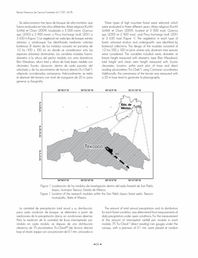
Se seleccionaron tres tipos de bosque de alta montaña, que fueron evaluados en tres años diferentes: Abies religiosa (Kunth) Schltdl. et Cham. (2009), localizado a 3 000 msnm; Quercus
spp. (2010) a 2 900 msnm, y Pinus hartwegii Lindl. (2011) a 3 650 m (Figura 1). La vegetación en cada tipo de bosque, estrato arbóreo y sotobosque fue identificada mediante colectas botánicas. El diseño de los módulos consistió en parcelas de 1.0 ha (100 x 100 m), en donde se consideraron solo las especies arbóreas dominantes. Las variables incluidas fueron: diámetro a la altura del pecho medida con cinta diamétrica Ben Meadows, altura total y altura de fuste limpio medida con clinómetro Suunto; ubicación, dentro de cada parcela, del arbolado y de los pluviómetros de lectura directa (Tru-Chek®), utilizando coordenadas cartesianas. Adicionalmente, se midió el desnivel del terreno con nivel de manguera de 20 m, para generar su fisiografía.
Three types of high mountain forest were selected, which were evaluated in three different years: Abies religiosa (Kunth) Schltdl. et Cham. (2009), located at 3 000 masl; Quercus
spp. (2010) at 2 900 masl., and Pinus hartwegii Lindl. (2011) at 3 650 masl (Figure 1). The vegetation in each type of forest, arboreal stratum and undergrowth, was identified by botanical collections. The design of the modules consisted of 1.0 ha (100 x 100 m) plots where only dominant tree species were considered. The variables included were: diameter at breast height measured with diametric tape (Ben Meadows), total height and clean stem height measured with Suunto clinometer; location, within each plot, of trees and direct reading pluviometers (Tru-Chek®), using Cartesian coordinates. Additionally, the unevenness of the terrain was measured with a 20 m hose level to generate its physiography.
Figura 1. Localización de los módulos de investigación dentro del ejido forestal de San Pablo Ixayoc, municipio Texcoco, Estado de México.
Figure 1. Location of the research modules within the San Pablo Ixayoc forest ejido, Texcoco
municipality, State of Mexico.
La cantidad de precipitación total anual y su distribución, para cada condición de bosque, se determinó a partir de mediciones de la precipitación diaria, en condiciones abiertas. Para la medición de la cantidad de lluvia interceptada, por módulo en cada módulo, se dispuso de una distribución aleatoria de 75 pluviómetros Tru-Check® (de lectura directa) bajo el dosel, equipo con una precisión de 0.1 mm, colocados a
The amount of total annual precipitation and its distribution for each forest condition, was determined from measurements of daily precipitation under open conditions. For the measurement of the amount of intercepted rainfall per module in each module, 75 Tru-Check® (direct reading) rain gauges under the canopy, with a precision of 0.1 mm, were placed at random
Flores et al., Intercepción de lluvia en bosques de...
69
una altura de 0.9 m sobre el nivel del piso para evitar el efecto de salpicado (Prasad, 2016).
El procedimiento para expresar la cantidad de lluvia interceptada fue mediante la diferencia entre la precipitación total medida en condiciones abiertas y el promedio general del volumen del agua de los colectores bajo el dosel de la vegetación, por cada evento de lluvia (Xiao et al., 2000; Sadeghi et al., 2015).
El estudio inició en el año 2009, en la parcela de oyamel, continuó en 2010, con encino y concluyó en 2011, con pino. Lo anterior permitió generar valores de intercepción por especie y evento de precipitación y anual. No se cuantificó el escurrimiento fustal.
Con base en la dispersión de puntos se analizó la relación de la precipitación total contra el porcentaje de intercepción. Con el fin de correlacionar estadísticamente los valores de precipitación y de intercepción para cada módulo, de manera independiente se ajustaron, mediante análisis de regresión, modelos no lineales de tipo logarítmico y exponencial (Hosseini et al., 2012; Sadegi et al., 2015).
Los criterios de selección de los mejores modelos ajustados incluyeron el coeficiente de determinación y significancia de los parámetros de regresión. El análisis estadístico se realizó en el programa SAS (SAS, 2007).
Resultados
Precipitación Media Anual
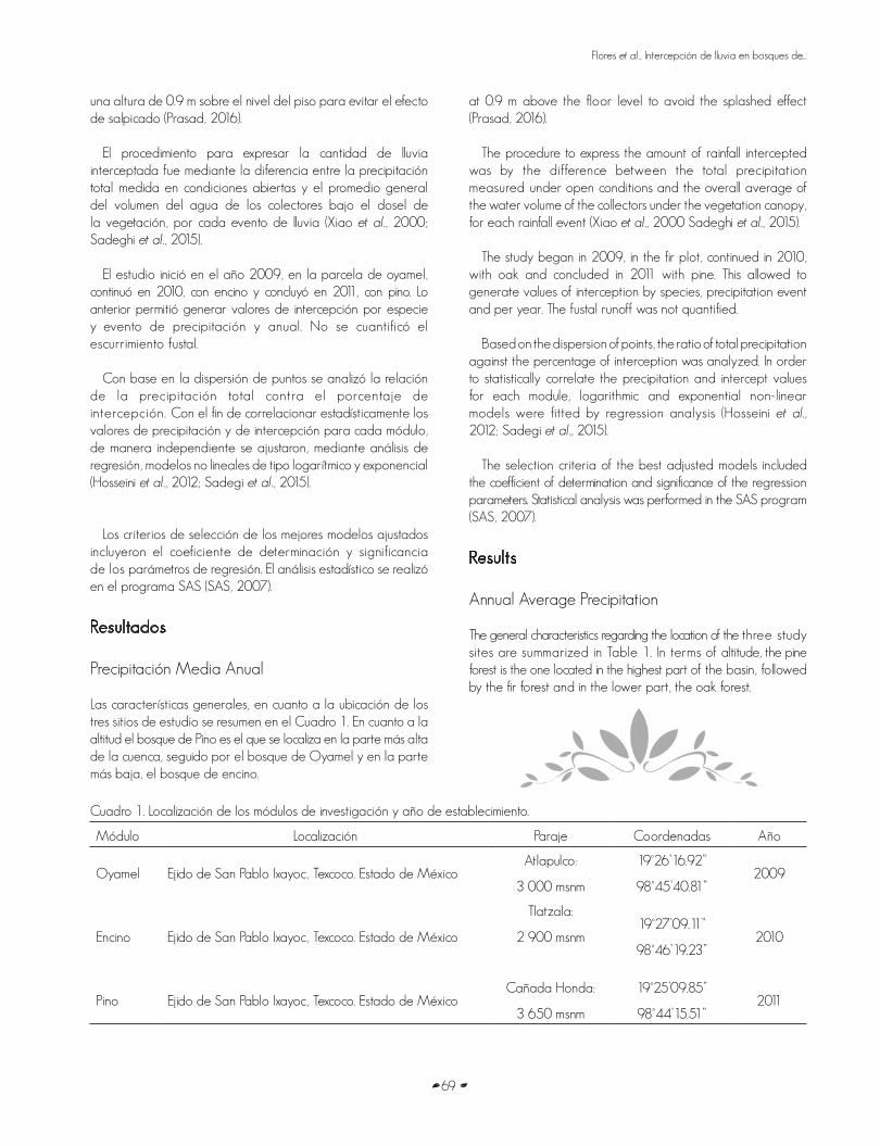
Las características generales, en cuanto a la ubicación de los tres sitios de estudio se resumen en el Cuadro 1. En cuanto a la altitud el bosque de Pino es el que se localiza en la parte más alta de la cuenca, seguido por el bosque de Oyamel y en la parte más baja, el bosque de encino.
Cuadro 1. Localización de los módulos de investigación y año de establecimiento.
Módulo Localización Paraje Coordenadas Año
Oyamel Ejido de San Pablo Ixayoc, Texcoco. Estado de MéxicoAtlapulco:
3 000 msnm
19°26’16.92”
98°45’40.81”2009
Encino Ejido de San Pablo Ixayoc, Texcoco. Estado de México
Tlatzala:
2 900 msnm19°27’09.11”
98°46’19.23”2010
Pino Ejido de San Pablo Ixayoc, Texcoco. Estado de MéxicoCañada Honda:
3 650 msnm
19°25’09.85”
98°44’15.51”2011
at 0.9 m above the floor level to avoid the splashed effect (Prasad, 2016).
The procedure to express the amount of rainfall intercepted was by the difference between the total precipitation measured under open conditions and the overall average of the water volume of the collectors under the vegetation canopy, for each rainfall event (Xiao et al., 2000 Sadeghi et al., 2015).
The study began in 2009, in the fir plot, continued in 2010, with oak and concluded in 2011 with pine. This allowed to generate values of interception by species, precipitation event and per year. The fustal runoff was not quantified.
Based on the dispersion of points, the ratio of total precipitation against the percentage of interception was analyzed. In order to statistically correlate the precipitation and intercept values for each module, logarithmic and exponential non-linear models were fitted by regression analysis (Hosseini et al., 2012; Sadegi et al., 2015).
The selection criteria of the best adjusted models included the coefficient of determination and significance of the regression parameters. Statistical analysis was performed in the SAS program (SAS, 2007).
Results
Annual Average Precipitation
The general characteristics regarding the location of the three study sites are summarized in Table 1. In terms of altitude, the pine forest is the one located in the highest part of the basin, followed by the fir forest and in the lower part, the oak forest.
Revista Mexicana de Ciencias Forestales Vol. 7 (37) : 65-76
70
Table 1. Location of research modules and year of establishment.
Module Location Place Coordinates Year
Fir Ejido de San Pablo Ixayoc, Texcoco. State of MexicoAtlapulco:
3 000 masl
19°26’16.92”
98°45’40.81”2009
Oak Ejido de San Pablo Ixayoc, Texcoco. State of MexicoTlatzala:
2 900 masl19°27’09.11”
98°46’19.23”2010
Pine Ejido de San Pablo Ixayoc, Texcoco. State of MexicoCañada Honda:
3 650 masl
19°25’09.85”
98°44’15.51”2011
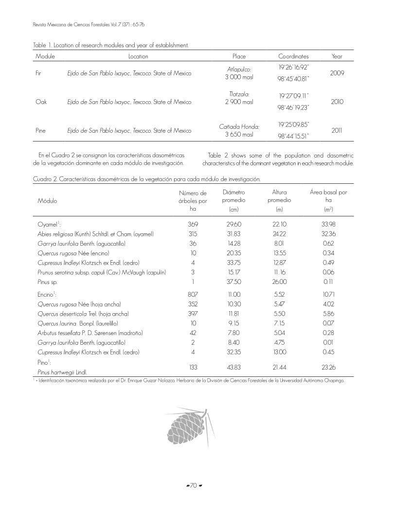
En el Cuadro 2 se consignan las características dasométricas de la vegetación dominante en cada módulo de investigación.
Cuadro 2. Características dasométricas de la vegetación para cada módulo de investigación.
MóduloNúmero de árboles por
ha
Diámetro promedio
(cm)
Altura promedio
(m)
Área basal por ha
(m2)
Oyamel1:
Abies religiosa (Kunth) Schltdl. et Cham. (oyamel)
Garrya laurifolia Benth. (aguacatillo)
Quercus rugosa Née (encino)
Cupressus lindleyi Klotzsch ex Endl. (cedro)
Prunus serotina subsp. capuli (Cav.) McVaugh (capulín)
Pinus sp.
369
315
36
10
4
3
1
29.60
31.83
14.28
20.35
33.75
15.17
37.50
22.10
24.22
8.01
13.55
12.87
11.16
26.00
33.98
32.36
0.62
0.34
0.49
0.06
0.11
Encino1:
Quercus rugosa Née (hoja ancha)
Quercus deserticola Trel. (hoja ancha)
Quercus laurina Bonpl. (laurelillo)
Arbutus tessellata P. D. Sørensen (madroño)
Garrya laurifolia Benth. (aguacatillo)
Cupressus lindleyi Klotzsch ex Endl. (cedro)
807
352
397
10
42
2
4
11.00
10.30
11.81
9.15
7.80
8.40
32.35
5.52
5.47
5.50
7.15
5.04
4.75
13.00
10.71
4.02
5.86
0.07
0.28
0.01
0.45
Pino1:
Pinus hartwegii Lindl. 133 43.83 21.44 23.26
1 = Identificación taxonómica realizada por el Dr. Enrique Guizar Nolazco. Herbario de la División de Ciencias Forestales de la Universidad Autónoma Chapingo.
Table 2 shows some of the population and dasometric characteristics of the dominant vegetation in each research module.

Flores et al., Intercepción de lluvia en bosques de...
71
For Pinus, Abies and Quercus, 72, 74 and 63 precipitation events were measured, respectively. Results indicate that for the Pinus hartwegii forest, a cumulative annual rainfall of 680.20 mm, in the Abies religiosa forest, 707.70 mm and for the Quercus spp. Forest, 503.00 mm (Table 3). The intervals of variation per event were 0.2-23.5 mm for Pinus, 0.2-33 mm for Abies and 0.2-38 mm for Quercus. Pinus and Abies recorded atypical data, the first of 82 mm and the second of 62 mm.
Measures of rainfall interception
The measurement of rainfall amounts during the interception process, the number of records of rainfall events varied in quantity, since only the significant ones were included for the evaluation years in the study area.
The calculation procedure consisted in measuring the amount of rainfall intercepted from the difference between the total precipitation measured under open conditions and the general average obtained from the volume of the water collected by the collectors under the canopy for each rain event, expressed as a percentage of total precipitation.
I = PT - P
BD
Table 2. Dominant vegetation of each research module.
ModuleNumber of trees
per ha
Average diameter
(cm)
Average height
(m)
Basal area by ha(m2)
Fir1:
Abies religiosa (Kunth) Schltdl. et Cham. (fir)
Garrya laurifolia Benth. (aguacatillo)
Quercus rugosa Née (oak)
Cupressus lindleyi Klotzsch ex Endl. (cedar)
Prunus serotina subsp. capuli (Cav.) McVaugh (capulín)
Pinus sp.
369
315
36
10
4
3
1
29.60
31.83
14.28
20.35
33.75
15.17
37.50
22.10
24.22
8.01
13.55
12.87
11.16
26.00
33.98
32.36
0.62
0.34
0.49
0.06
0.11
Oak1:
Quercus rugosa Née (broad-leaved)
Quercus deserticola Trel. (broad-leaved)
Quercus laurina Bonpl. (laurelillo)
Arbutus tessellata P. D. Sørensen (arbutus)
Garrya laurifolia Benth. (aguacatillo)
Cupressus lindleyi Klotzsch ex Endl. (cedar)
807
352
397
10
42
2
4
11.00
10.30
11.81
9.15
7.80
8.40
32.35
5.52
5.47
5.50
7.15
5.04
4.75
13.00
10.71
4.02
5.86
0.07
0.28
0.01
0.45
Pine1:
Pinus hartwegii Lindl.133 43.83 21.44 23.26
1 = Taxonomic identification performed by Dr. Enrique Guizar Nolazco from the. Herbario of the División de Ciencias Forestales of the Universidad Autónoma Chapingo.
Para el caso de Pinus, Abies y Quercus, se midieron 72, 74 y 63 eventos de precipitación, respectivamente. Los resultados indican que para el bosque de Pinus hartwegii, se presentó una precipitación acumulada anual de 680.20 mm, en el bosque de Abies religiosa de 707.70 mm y para el bosque de Quercus spp de 503.00 mm (Cuadro 3). Los intervalos de variación por evento fueron para Pinus de 0.2-23.5 mm, para Abies de 0.2–33 mm y para Quercus de 0.2–38 mm. Pinus y Abies, registraron datos atípicos, el primero de 82 mm y el segundo de 62 mm.
Medidas de Intercepción de lluvia
La medición de las cantidades de lluvia durante el proceso de intercepción, el número de registros de los eventos de lluvia variaron en cantidad, ya que solo se incluyeron los significativos para los años de evaluación en la zona de estudio.
El procedimiento de cálculo consistió en medir la cantidad de lluvia interceptada, a partir de la diferencia entre la precipitación total, medida en condiciones abiertas, y el promedio general obtenido del volumen del agua de los colectores localizados bajo el dosel por cada evento de lluvia, expresada como porcentaje de la precipitación total.
I = PT - P
BD
Revista Mexicana de Ciencias Forestales Vol. 7 (37) : 65-76
72
Donde:I = Cantidad de lluvia interceptadaP
T = Cantidad de precipitación total medida en áreas
aledañas sin vegetaciónP
BD = Cantidad de precipitación medida bajo dosel
Los resultados se resumen en el Cuadro 3.
Where:I = Amount of intercepte rainfallP
T = Amount of total rainfal measured in neighboring
areas to vegetation P
BD = Amount of rainfal measured under the canopy
Results are summarized in Table 3.
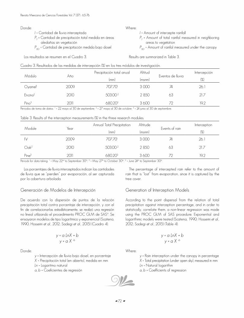
Cuadro 3. Resultados de las medidas de intercepción (%) en los tres módulos de investigación.
Módulo AñoPrecipitación total anual
(mm)
Altitud
(msnm)Eventos de lluvia
Intercepción
(%)
Oyamel1 2009 707.701 3 000 74 26.1
Encino2 2010 503.00 2 2 850 63 21.7
Pino3 2011 680.203 3 600 72 19.2Periodos de toma de datos: 1 = 22 mayo al 30 de septiembre; 2 = 27 mayo al 30 de octubre: 3 = 24 junio al 30 de septiembre.
Table 3. Results of the interception measurements (%) in the three research modules.
Module YearAnnual Total Precipitation
(mm)
Altitude
(msnm)Events of rain
Interception
(%)
Fir1 2009 707.701 3 000 74 26.1
Oak2 2010 503.00 2 2 850 63 21.7
Pine3 2011 680.203 3 600 72 19.2Periods for data taking: 1 = May 22nd to September 30th; 2 = May 27th to October 30th; 3 = June 24th to September 30th.
Los porcentajes de lluvia interceptados indican las cantidades de lluvia que se “pierden” por evaporación, al ser capturada por la cobertura arbolada.
Generación de Modelos de Intercepción
De acuerdo con la dispersión de puntos de la relación precipitación total contra porcentaje de intercepción, y con el fin de correlacionarlas estadísticamente, se realizó una regresión no lineal utilizando el procedimiento PROC GLM de SAS®. Se ensayaron modelos de tipo logarítmico y exponencial (Scatena, 1990; Hosseini et al., 2012; Sadegi et al., 2015) (Cuadro 4):
y = a LnX + b
y = a X -b
Donde: y = Intercepción de lluvia bajo dosel, en porcentajeX = Precipitación total (en abierto), medida en mmLn = Logaritmo naturala, b = Coeficientes de regresión
The percentage of intercepted rain refer to the amount of rain that is “lost” from evaporation, since it is captured by the tree cover.
Generation of Interception Models
According to the point dispersal from the relation of total precipitation against interception percentage, and in order to statistically, correlate them, a non-linear regression was made using the PROC GLM of SAS procedure. Exponential and logarithmic models were tested (Scatena, 1990; Hosseini et al., 2012; Sadegi et al., 2015) (Table 4):
y = a LnX + b
y = a X -b
Where: y = Rain interception under the canopy in percentage X = Total precipitation (under open sky), measured in mmLn = Natural logarithm a, b = Coefficients of regression
Flores et al., Intercepción de lluvia en bosques de...
73
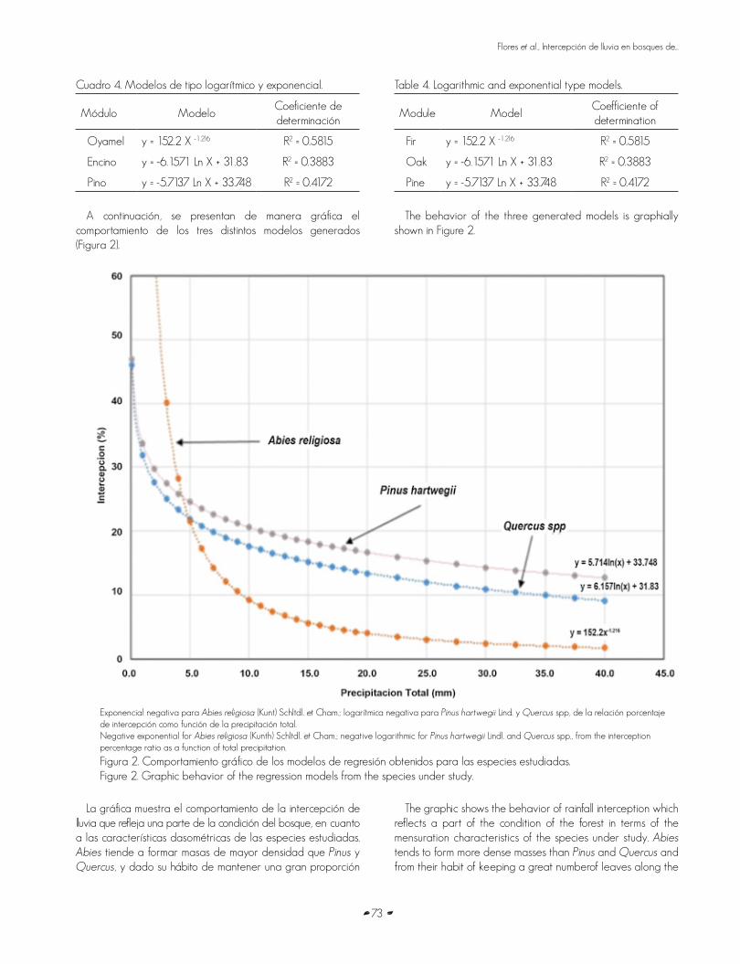
Cuadro 4. Modelos de tipo logarítmico y exponencial.
Módulo ModeloCoeficiente de determinación
Oyamel y = 152.2 X -1.216 R2 = 0.5815
Encino y = -6.1571 Ln X + 31.83 R2 = 0.3883
Pino y = -5.7137 Ln X + 33.748 R2 = 0.4172
A continuación, se presentan de manera gráfica el comportamiento de los tres distintos modelos generados (Figura 2).
Table 4. Logarithmic and exponential type models.
Module ModelCoefficiente of determination
Fir y = 152.2 X -1.216 R2 = 0.5815
Oak y = -6.1571 Ln X + 31.83 R2 = 0.3883
Pine y = -5.7137 Ln X + 33.748 R2 = 0.4172
The behavior of the three generated models is graphially
shown in Figure 2.
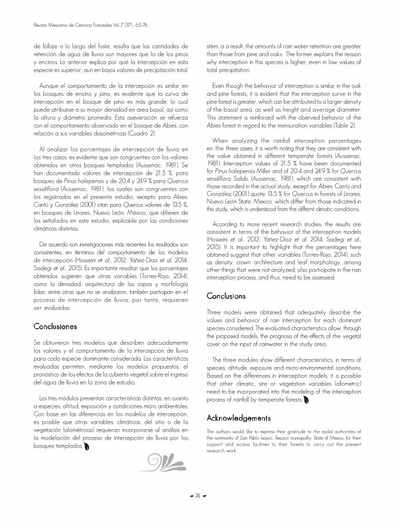
Exponencial negativa para Abies religiosa (Kunt) Schltdl. et Cham.; logarítmica negativa para Pinus hartwegii Lind. y Quercus spp, de la relación porcentaje de intercepción como función de la precipitación total.Negative exponential for Abies religiosa (Kunth) Schltdl. et Cham.; negative logarithmic for Pinus hartwegii Lindl. and Quercus spp., from the interception percentage ratio as a function of total precipitation.
Figura 2. Comportamiento gráfico de los modelos de regresión obtenidos para las especies estudiadas. Figure 2. Graphic behavior of the regression models from the species under study.
La gráfica muestra el comportamiento de la intercepción de lluvia que refleja una parte de la condición del bosque, en cuanto a las características dasométricas de las especies estudiadas. Abies tiende a formar masas de mayor densidad que Pinus y Quercus, y dado su hábito de mantener una gran proporción
The graphic shows the behavior of rainfall interception which reflects a part of the condition of the forest in terms of the mensuration characteristics of the species under study. Abies
tends to form more dense masses than Pinus and Quercus and from their habit of keeping a great numberof leaves along the
Revista Mexicana de Ciencias Forestales Vol. 7 (37) : 65-76
74
de follaje a lo largo del fuste, resulta que las cantidades de retención de agua de lluvia son mayores que la de los pinos y encinos. Lo anterior explica por qué la intercepción en esta especie es superior, aun en bajos valores de precipitación total.
Aunque el comportamiento de la intercepción es similar en los bosques de encino y pino, es evidente que la curva de intercepción en el bosque de pino es más grande, lo cual puede atribuirse a su mayor densidad en área basal, así como la altura y diámetro promedio. Esta aseveración se refuerza con el comportamiento observado en el bosque de Abies, con relación a sus variables dasométricas (Cuadro 2).
Al analizar los porcentajes de intercepción de lluvia en los tres casos, es evidente que son congruentes con los valores obtenidos en otros bosques templados (Aussenac, 1981). Se han documentado valores de intercepción de 21.5 %, para bosques de Pinus halepensis y de 20.4 y 24.9 % para Quercus
sessiliflora (Aussenac, 1981), los cuales son congruentes con los registrados en el presente estudio, excepto para Abies. Cantú y González (2001) citan para Quercus valores de 13.5 %, en bosques de Linares, Nuevo León, México, que difieren de los señalados en este estudio, explicable por las condiciones climáticas distintas.
De acuerdo con investigaciones más recientes los resultados son consistentes, en términos del comportamiento de los modelos de intercepción (Hosseini et al., 2012; Yáñez-Díaz et al. 2014; Sadegi et al., 2015). Es importante resaltar que los porcentajes obtenidos sugieren que otras variables (Torres-Rojo, 2014), como la densidad, arquitectura de las copas y morfología foliar, entre otras que no se analizaron, también participan en el proceso de intercepción de lluvia; por tanto, requieren ser evaluadas.
Conclusiones
Se obtuvieron tres modelos que describen adecuadamente los valores y el comportamiento de la intercepción de lluvia para cada especie dominante considerada. Las características evaluadas permiten, mediante los modelos propuestos, el pronóstico de los efectos de la cubierta vegetal sobre el ingreso del agua de lluvia en la zona de estudio.
Los tres módulos presentan características distintas, en cuanto a especies, altitud, exposición y condiciones micro ambientales. Con base en las diferencias en los modelos de intercepción, es posible que otras variables, climáticas, del sitio o de la vegetación (alométricas) requieran incorporarse al análisis en la modelación del proceso de intercepción de lluvia por los bosques templados.
stem, a a result, the amounts of rain water retention are greater than those from pine and oaks. The former explains the reason why interception in this species is higher, even in low values of total precipitation.
Even though the behavior of interception is similar in the oak and pine forests, it is evident that the interception curve in the pine forest is greater, which can be attributed to a larger density of the basal area, as well as height and average diameter. This statement is reinforced with the oberved behavior of the Abies forest in regard to the mensuration variables (Table 2).
When analyzing the rainfall interception percentages en the three cases, it is worth noting that they are consistent with the value obtained in different temperate forests (Aussenac, 1981). Interception values of 21.5 % have been documented for Pinus halepensis Miller and of 20.4 and 24.9 % for Quercus
sessiliflora Salisb. (Aussenac, 1981), which are consistent with those recorded in the actual study, except for Abies. Cantú and González (2001) quote 13.5 % for Quercus in forests of Linares,
Nuevo León State, Mexico, which differ from those indicated in this study, which is understood from the differnt climatic conditions.
According to more recent research studies, the results are consistent in terms of the behavior of the interception models (Hosseini et al., 2012; Yáñez-Díaz et al. 2014; Sadegi et al., 2015). It is important to highlight that the percentages here obtained suggest that other variables (Torres-Rojo, 2014), such as density, crown architecture and leaf morphology, among other things that were not analyzed, also participate in the rain interception process, and thus, need to be assessed.
Conclusions
Three models were obtained that adequately describe the values and behavior of rain interception for each dominant species considered. The evaluated characteristics allow, through the proposed models, the prognosis of the effects of the vegetal cover on the input of rainwater in the study area.
The three modules show different characteristics, in terms of species, altitude, exposure and micro-environmental conditions. Based on the differences in interception models, it is possible that other climatic, site or vegetation variables (allometric) need to be incorporated into the modeling of the interception process of rainfall by temperate forests.
Acknowledgements
The authors would like to express their gratitude to the ejidal authorities of the community of San Pablo Ixayoc, Texcoco municipality, State of Mexico, for their support and access facilities to their forests to carry out the present research work.
Flores et al., Intercepción de lluvia en bosques de...
75
Agradecimientos
Los autores desean hacer patente su agradecimiento a las autoridades ejidales de la comunidad de San Pablo Ixayoc, municipio de Texcoco, Estado de México por su apoyo y las facilidades de acceso a sus bosques, para la realización del presente trabajo de investigación.
Conflicto de intereses
Los autores declaran no tener conflicto de intereses.
Contribuciones por autor
Eulogio Flores Ayala: planeación y diseño de la investigación, supervisión de trabajo de campo, toma de datos en campo, análisis de la aplicación de los resultados y redacción del documento; Vidal Guerra De la Cruz: apoyo de la investigación, análisis de los datos de campo, redacción, estructura y presentación de los resultados dentro del documento; Gerardo H. Terrazas González: análisis estadístico y ajuste de los modelos generados; Fernando Carrillo Anzures: Toma de datos en campo, evaluación de la aplicabilidad de la información obtenida en campo e interpretación silvícola; Fabián Islas Gutiérrez: evaluación de la aplicabilidad de la información obtenida en campo y revisión en el ajuste de las ecuaciones; Miguel Acosta Mireles: toma de datos de campo, apoyo de la investigación, análisis de los datos de campo, interpretación del ajuste de los modelos generados, redacción, estructura y presentación de los resultados dentro del documento; Enrique Buendía Rodríguez: revisión y depuración de datos de campo y presentación de los resultados dentro del documento.
Referencias
André F., J Mathieu. and Q. Ponette. 2008. Effects of biological and meteorological factors on stemflow chemistry within a temperate mixed Oak-beech stand. Science of the Total Environment 393(1):72-83.
Aussenac, G. 1981. L’interception des précipitations par les peuplements forestiers. La Houille Blanche (7-8):531-536.
Cantú S., I. and H. González R. 2001. Interception loss, throughfall and stemflow chemistry in pine and oak forests in northeastern Mexico. Tree Physiology 21:1009-1013.
David, J., F. Valente and J. Gash. 2005. Evaporation of intercepted rainfall. In: Anderson, M. (ed.). Encyclopedia of Hydrological Sciences. John Wiley and Sons. West Sussex, England. pp. 627–634.
Fleischbein, K., W. Wilcke, R. Goller, J. Boy, C. Valarezo, W. Zech and K. Knoblich. 2005. Rainfall interception in a lower montane forest in Ecuador: effects of canopy properties. Hydrological Processes 19(7):1355-1371.
Flores, A. E., F. Becerra, L., E. Buendía, R., F. Carrillo A. y M. Acosta M. 2011. Intercepción de lluvia por vegetación forestal. Estado actual de la investigación en México e Hidalgo. Aportes para el desarrollo del estado de Hidalgo. In: Colegio del Estado de Hidalgo (comp.). Vol.1 Agua y Medio Ambiente. Ed. Miguel Ángel Porrúa. México, D.F., México. pp. 151-166.
Hosseini, G. B., S. M., P. Attarod, V. Bayramzadeh, M. T. Ahmadi and A. Radmehr. 2012. Throughfall, stemflow, and rainfall interception in a natural pure forest of chestnut-leaved Oak (Quercus castaneifolia C.A. Mey.) in the Caspian Forest of Iran. Annals of Forest Research 55(2):197-206.
Kittredge, J. 1948. Forest influences. The effects of woody vegetation on climate, water, and soil, with applications to the conservation of water and the control of floods and erosion. Dover Publications, Inc. New York, NY, USA. 349 p.
Levia, D. F. and S. R. Herwitz. 2005. Interspecific variation of bark water storage capacity of three deciduous tree species in relation to stemflow yield and solute flux to forest soils. Catena 64: 117-137.
Conflict of interests
The authors declare no conflict of interests
Contributions by author
Eulogio Flores Ayala: design and planning of the research, supervision of field work, data taking at the field, analysis of the application of results and writing of the document; Vidal Guerra De la Cruz: research support, field data analysis, structuring, presentation and writing of results in the document; Gerardo H. Terrazas González: statistical analysis and fitting of the generated models; Fernando Carrillo Anzures: field data taking, assessment of the aplicability of the information taken in the field and forestry interpretation; Fabián Islas Gutiérrez: assessment of the aplicability of the information taken in the field and review of the fit of the equations; Miguel Acosta Mireles: data taking at the field, research support, field data analysis, interpretation of the fit to the generated models, structuring, presentation and writing of results in the document; Enrique Buendía Rodríguez: field data review and depuration and presentation of results in the document.
End of the English version
Lida, S., T. Tanaka and M. Sugita. 2005. Change of interception process due to the succession from Japanese red pine to evergreen oak. Journal of Hydrology 315: 154–166.
Manfroi O, K. Koichiro, T. Nobuaki, S. Masakazu, M. Nakagawa, T. Nakashizuka and L. Chong. 2004. The stemflow of trees in a Bornean lowland tropical forest. Hydrological Processes 18 (13): 2455-2474.
Marin, T. C., W. Bouten and J. Sevink 2000. Gross rainfall and its partitioning into throughfall, stemflow and evaporation of intercepted water in four forest ecosystems in western Amazonia. Journal of Hydrology 237:40-57.
Návar Ch., J. J., J. Méndez G. y H. González R. 2008. Intercepción de la lluvia en especies de leguminosas del nordeste de México. Terra Latinoamericana 26 (1):61-68.
Prasad G., C., L. Adrian Bruijnzeel, M. W. Lubczynski, M. Ravelona, B. W. Zwartendijk and H. J. (Ilja) van Meerveld. 2016. Measurement and modelling of rainfall interception by two differently aged secondary forests in upland Eastern Madagascar. Journal of Hydrology. doi: http://dx.doi.org/10.1016/j.jhydrol.2016.10.032.
Sadeghi S. M. M., P. Attarod and T. G. Pypker. 2015. Differences in rainfall interception during the growing and non-growing seasons in a Fraxinus rotundifolia Mill. plantation located in a semiarid climate. Journal of Agricultural Science and Technology 17 (1):145-156.
Statistical Analysis System Institute (SAS). 2007. The SAS System for Windows ver. 9.1.3. SAS Institute Inc. Cary, NC, USA.
Scatena, F. N. 1990. Watershed scale rainfall interception on two forested watersheds in the Luquillo mountains of Puerto Rico. Journal of Hydrology 113 (1990): 89-102.
Siegert, C. M. and D. F. Levia 2014. Seasonal and meteorological effects on differential stemflow funneling ratios for two deciduous tree species. Journal of Hydrology 519: 446–454.

Revista Mexicana de Ciencias Forestales Vol. 7 (37) : 65-76
76
Staelens J., A. D. Schrijver, K. Verheyen and N. E. C. Verhoest. 2008. Rainfall partitioning into throughfall, stemflow, and interception within a single beech (Fagus sylvatica L.) canopy: influence of foliation, rain event characteristics, and meteorology. Hydrological Processes 22 (1): 33-45.
Taghi A. M., P. Attarod and V. Bayramzadeh. 2013. The role of rainfall size in canopy interception loss: An observational study in a typical beech forest. Middle-East Journal of Scientific Research 3(7): 876-882.
Torres-Rojo, J. M. 2014. Exploring volume growth-density of mixed multiaged stands in northern Mexico. Agrociencia 48 (4): 447–461.
Yáñez-Díaz, M. I., I. Cantú-Silva, H. González-Rodríguez y J. I. Uvalle-Sauceda. 2014. Redistribución de la precipitación en tres especies arbustivas nativas y una plantación de eucalipto del noreste de México. Tecnología y Ciencias del Agua 5 (2):71-84.
Xiao, Q., E. G. McPherson, S. L. Ustin, M. E. Grismer and J. R. Simpson. 2000. Winter rainfall interception by two mature open-grown trees in Davis, California. Hydrological Processes 14(4): 763-784.