de la junta de andalucía y por el fondo social...
TRANSCRIPT
El camino ahora asciende hasta alcanzar un cruce el cual une nuestro recorrido con el Camino de Santiago hasta el fnal del mismo, en el albergue. Durante el ascenso, el municipio de Almogía se asoma por entre las montañas para ofrecernos una bonita panorámica del mismo desde el sur. A la izquierda dejamos una antigua era que hoy en día está prácticamente oculta. Desde este camino parte un sendero a la derecha, llamado la cuesta del Morro, que en continuo descenso nos llevará hasta el arroyo de los Carpinteros, en la parte más baja del pueblo. Entre la vegetación aparecen aladierno, bolina, altabaca, nevadilla, manzanilla amarga, manzanilla yesquera, algarrobos y encinas. Desde este tramo puede observarse al fondo del valle las ruinas del molino del Obispo, el tajo de la Rambla y el cerro Santi Petri, punto más elevado del municipio.
El fnal del recorrido lo realizaremos a través del casco urbano, partiendo desde la zona de la Rehoyada, donde están el colegio y el instituto, para subir el entramado de callejuelas que llevan hasta la plaza de la Constitución, donde encontramos el Ayuntamiento, y algo más arriba la Iglesia de la Asunción, la Ermita del Sagrado Corazón y la antigua herrería. El ascenso nos lleva hasta la Loma, donde la carretera nos llevará hacia la izquierda de nuevo hasta el albergue.
Este sendero nos lleva al inicio del carril que rodea el Cerro Bermejo por su ladera noreste y nos ofrece estupendas vistas al río Campanillas. Aparecen especies vegetales nuevas, como la bufalaga (Thymelaea hirsuta), y en zonas más húmedas la zarzamora (Rubus ulmifolius) y los juncos (Juncus sp.). En todo el recorrido es fácil la observación de diferentes especies de aves, abundando los fringílidos, cernícalos, túrdidos, perdices, etc. Un poco más adelante pasamos justo por encima de una antigua yesera, actualmente cerrada, la cual no se puede observar desde el propio carril.
Éste nos lleva de nuevo hasta la carretera, la cual cruzaremos para tomar hacia la izquierda la vereda de los Teodoros o el camino del Llano del Espinar, que casi en continuo descenso nos llevará hasta el cauce del arroyo El Espinar, que se alimenta de las aguas de las fuentes circundantes (Layún, Soltán, etc.) y riega los naranjos y otros frutales que abundan en la zona. Un frondoso olmo rodeado de cañaverales nos invita a tomar aire junto al arroyo, donde numerosas aves se acercan a refrescarse.
Al llegar a la perrera, en la siguiente bifurcación, tomamos el sendero que parte a la derecha, zona en la que abundan especies autóctonas como el palmito, el hinojo, las esparragueras, la retama, el lentisco, el acebuche, el marrubio o la jara blanca. También aparecen especies introducidas pero ya muy comunes en nuestros campos, como la chumbera o la pita, procedentes de América. Podremos observar los primeros algarrobos, y con suerte, cruzarnos con alguna cabra montés. Este tramo nos llevará de nuevo hasta la carretera, pasando cerca del depósito de agua municipal.
Una vez en la carretera, la tomamos con la máxima precaución hacia la izquierda, y en 100 metros llegaremos a uno de los miradores del pueblo, que nos abre una hermosa panorámica hacia el valle del río Campanillas, principal cauce que de forma tortuosa vertebra de norte a sur el término municipal. En los últimos días de primavera, las fores de las adelfas tiñen de rosa el cauce, que en épocas de abundantes lluvias lleva un gran caudal de agua. En el otro extremo del mirador parte un sendero paralelo a la carretera que nos lleva por un pequeño cerro desde el cual las vistas son más espectaculares aún si cabe. El Tajo de la Pela puede verse a la izquierda, sobrevolado por la colonia de cernícalos que año tras año crían en el mismo.
Esta ruta nos descubrirá el llamado Llano El Espinar, una zona agrícola cercana al municipio, que mezcla los cultivos de secano, principalmente de olivos y almendros, con un entramado de vegetación autóctona mediterránea, regada por las aguas del arroyo del mismo nombre “Arroyo El Espinar”. Su cómodo recorrido nos invita a conocer este entorno en un agradable paseo de 6,5 km sin desniveles excesivamente acusados.
El itinerario parte desde el albergue de Almogía. Desde aquí tomamos la carretera hacia la izquierda, y en pocos metros partirá un carril a la derecha, señalizado con las balizas del Camino de Santiago. Justo en la primera bifurcación, frente a la Venta Garrido, tomamos el carril hacia la derecha, avanzando por una pista ancha, rodeada de cultivos de almendros, olivos y alguna que otra higuera, y dejando a la izquierda un picadero para caballos.
This path leads to the beginning of the track that surrounds the Bermejo hill from its north-eastern face, from where great views over the Campanillas river can be enjoyed. Here, new plant species appear, such as fleshy-leaf thymelaea (Thymelaea hirsuta), and in the wetter areas, elmleaf blackberries (Rubus ulmifolius) and rushes (Juncus sp.). Different types of birds can easily be observed here, with an abundance of finches, kestrels, thrushes, partridges, etc. A little further ahead, the path passes by an old plaster factory, now closed, which cannot be seen from the track itself. Following this track brings you back to the road, which, crossed to the left, leads to the Vereda de Teodoro or the Llano del Espinar path. This runs down to the riverbed of El Espinar stream, which feeds on the waters from the surrounding sources (Layún, Soltan, etc.) and waters the orange and other fruit trees that are plentiful in this area. A leafy English elm (Ulmus minor) surrounded by giant reeds (Arundo donax) is the perfect spot to take in the fresh air along the creek, where many birds come to cool off.
The road now ascends to a junction where this tour coincides with the Camino de Santiago until the end of the route in the hostel. During the ascent, the town of Almogía peeks through the mountains offering a stunning panoramic view from the south. To the left, you pass by a former wheat threshing site that today is virtually hidden. From this track, a path to the right begins, called La Cuesta del Morro slope, which continuously declines to lead to the Carpinteros stream in the lowest part of the town. Amongst the vegetation, you can see Mediterranean buckthorns (Rhamnus alaternus), bolina shrubs (Genista umbellata), strong-smelling inula (Dittrichia viscosa), silvery whitlow-worts (Paronychia argentea), eternal flowers (Helichrysum stoechas), Mediterranean phagnalons (Phagnalon saxatile), carob trees (Ceratonia siliqua) and holm oaks (Quercus rotundifolia). From here, the valley floor with the Molino del Obispo mill, La Rambla cliff and the Santi Petri hill, the highest point of this local region, can be seen.
The end of the tour takes you through the streets of the town, starting from the Rehoyada area, where the school and the college are located. Climbing through the network of narrow streets leading to the Constitución square, you can see the town hall and, further on, La Asunción church, the Sagrado Corazón chapel and the old blacksmith. The ascent takes you to La Loma residential area, where the road leads to the left again, returning to the hostel.
ENGLISH VERSION
This route displays the Llano El Espinar, a flat agricultural area near the village. Here, a mix of crops can be found, mainly olive (Olea europaea) and almond trees (Prunus dulcis), amongst Mediterranean native vegetation, irrigated by the waters of El Espinar stream. It is a comfortable route that invites you to learn about this environment on an easy and nice 6.5-km walk.
The route starts at the Almogía hostel, from where you must take the road to the left. In a few metres a lane starts on the right, marked with the signs to the Camino de Santiago. Turning right at the first fork, opposite a house known as Venta Garrido (a former road-side rural restaurant), you must take the lane to the right, coming to a wide track surrounded by crops of almonds (Prunus dulcis), olives (Olea europaea) and some fig trees (Ficus carica) and passing a horse-riding paddock on the left.
Upon arrival at the local kennels, at the next fork, the path that starts on the right must be taken. This area is abundant with native species such as Mediterranean palm trees (Chamaerops humilis), fennel (Foeniculum vulgare), asparagus (Asparagus sp.), retama broom bushes (Retama sphaerocarpa), mastic trees (Pistacia lentiscus), wild olives (Olea europaea ssp. sylvestris), white horehound (Marrubium sp.) and white-leaved rockroses (Cistus albidus). Introduced but already very commonplace species from America also appear in these fields, such as Argentine pricklypears (Opuntia ficus-indica) and century plants (Agave americana). The first carob trees (Ceratonia siliqua) can be seen, and also hopefully some wild goats. This stretch leads back to the road, passing near to the town's water reservoir.
Once on the road, you must carefully continue to the left, and in 100 metres reaching one of the village viewpoints, which offers a beautiful panorama over the valley of the Campanillas river. This river winds around the village from north to south. In the last days of spring, the flowers of the oleanders (Nerium oleander) tint the water pink, and heavy rainfall can bring a high volume of water to the river. At the other end of the viewpoint, a parallel path to the road begins, which leads over a small hill from where the views are possibly even more spectacular than before. The La Pela cliff, which houses a colony of kestrels that breed there year after year, can be seen on the left.
RUTA 3: LLANO EL RUTA 3: LLANO EL ESPINAR ESPINAR
Descarga tu ruta aquí Descarga tu ruta aquí
Vistas del Tajo de la Rambla desde el sendero
Flor de jara blanca
Flor de esparraguera
Observación de aves junto a la Venta Garrido
Mirador a la entrada de Almogía
Flor de trébol estrellado
Elaborado por los trabajadores del Taller de Empleo Alfarnate – Alfarnatejo - Almogía, especialidad MONITOR DE SENDAS DE LA NATURALEZA, en Almogía.
TELÉFONOS DE INTERÉS TELÉFONOS DE INTERÉS- Centro de Salud951 298 932- Servicio de Transporte Interurbano www.ctmam.es- Guardia Civil 925 430 016- Ayuntamiento de Almogía 952 430 025
Financiado por la Consejería de Educación, Cultura y Deporte de la Junta de Andalucía y por el Fondo Social Europeo.
RUTA 3:RUTA 3:LLANO EL ESPINARLLANO EL ESPINAR
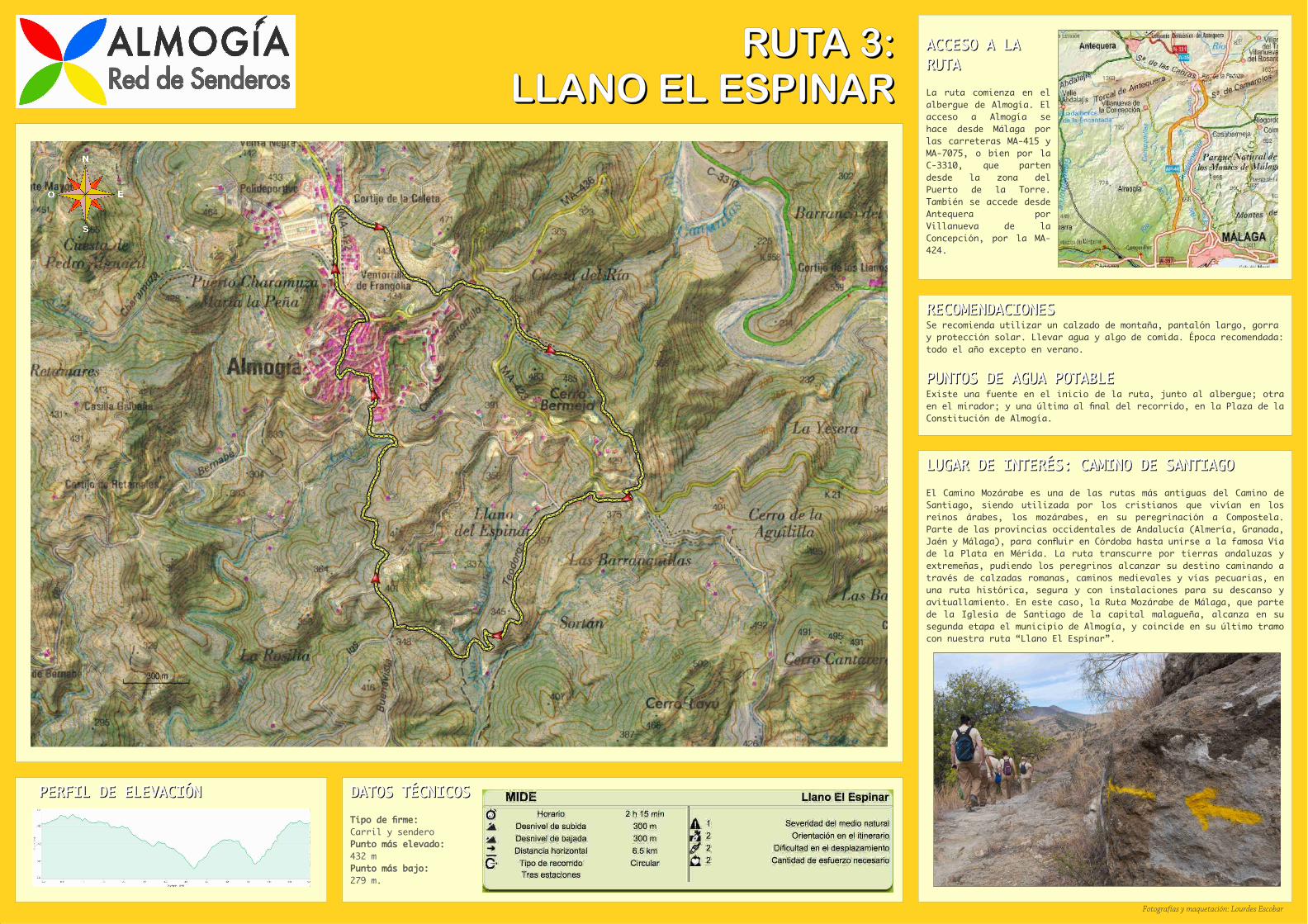
PERFIL DE ELEVACIÓNPERFIL DE ELEVACIÓN
ACCESO A LA ACCESO A LA RUTARUTA
La ruta comienza en el albergue de Almogía. El acceso a Almogía se hace desde Málaga por las carreteras MA-415 y MA-7075, o bien por la C-3310, que parten desde la zona del Puerto de la Torre. También se accede desde Antequera por Villanueva de la Concepción, por la MA-424.
DATOS TÉCNICOSDATOS TÉCNICOS
Tipo de frme: Carril y senderoPunto más elevado: 432 mPunto más bajo: 279 m.
RECOMENDACIONESRECOMENDACIONESSe recomienda utilizar un calzado de montaña, pantalón largo, gorra y protección solar. Llevar agua y algo de comida. Época recomendada: todo el año excepto en verano.
PUNTOS DE AGUA POTABLEPUNTOS DE AGUA POTABLEExiste una fuente en el inicio de la ruta, junto al albergue; otra en el mirador; y una última al fnal del recorrido, en la Plaza de la Constitución de Almogía.
LUGAR DE INTERÉS: CAMINO DE SANTIAGOLUGAR DE INTERÉS: CAMINO DE SANTIAGO
El Camino Mozárabe es una de las rutas más antiguas del Camino de Santiago, siendo utilizada por los cristianos que vivían en los reinos árabes, los mozárabes, en su peregrinación a Compostela. Parte de las provincias occidentales de Andalucía (Almería, Granada, Jaén y Málaga), para confuir en Córdoba hasta unirse a la famosa Vía de la Plata en Mérida. La ruta transcurre por tierras andaluzas y extremeñas, pudiendo los peregrinos alcanzar su destino caminando a través de calzadas romanas, caminos medievales y vías pecuarias, en una ruta histórica, segura y con instalaciones para su descanso y avituallamiento. En este caso, la Ruta Mozárabe de Málaga, que parte de la Iglesia de Santiago de la capital malagueña, alcanza en su segunda etapa el municipio de Almogía, y coincide en su último tramo con nuestra ruta “Llano El Espinar”.
Fotografías y maquetación: Lourdes Escobar